midatlanticweather
-
Posts
4,888 -
Joined
-
Last visited
Content Type
Profiles
Blogs
Forums
American Weather
Media Demo
Store
Gallery
Everything posted by midatlanticweather
-
This definitely has the skip factor miss for the area with Miller B.. Not liking the vibe or trends.
-

January Medium/Long Range Discussion
midatlanticweather replied to WinterWxLuvr's topic in Mid Atlantic
You know this is not a KU-level storm, so it is not going to go over well!! I love snow, but this is like getting cold cuts after so many had a huge feast. I will take it because I love snow, but I need the multiple-hour SN+ to be really happy! This is not the Ji-level event, and you know it! -
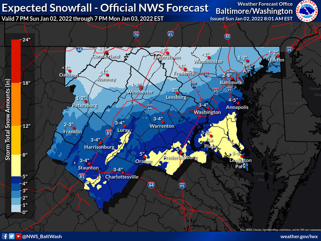
A little over 2 inches in Purcellville, but northern Loudoun has table scraps.
-
1.75 on the deck. About an inch on the grass. Roads just coated. Hate that encroaching dry line to the NW
-
Good seeing you here
-
38/32 - Precip is close!
-
41/34 in Purcellville.
-
Did anyone see this?
-
Does anyone other than a weenie use the hrrr for looking at snow forecasts this far out? Maybe at game time for discrete enhancements. I dunno.
-
47/38
-
2011 was my year of tragedy. Lost my brother in a freak accident in September and my dad in December. Death sucks... It is not going to be easy and firsts are freaking difficult. It does heal over time and the good memories will crowd out the pain over time. No candy coating any of it though. You will make it through. Definitely lean on your friends and family and let the process work it out.. But do face it as going through the process will help. It took me 3 months before a stupid emotional movie helped me weep and finally start healing. Hang in there. Praying for you. Reach out if you need to just let it out and have no one to share it with. Do not face it all alone.
-
Watches expanded
-
Forgive me if posted, but NWS has definitely increased thoughts.

-
My thinking is that the precip shield and not the north tick is what we see going forwards. Probably just enough to move watches/advisories one zone north and west. But this thing has done a ton on models the last 24 hours so I hope it Keeps it going a little longer so I can shovel!
-
Ya.. The cutoff line is consistent from what I see.. But at least it came around
-
Intense lines of rain and wind in Purcellville the last 20 minutes. Feels like summer time storminess!!!
-
January Medium/Long Range Discussion
midatlanticweather replied to WinterWxLuvr's topic in Mid Atlantic
As far as shifting, I do not think anymore that we see a huge shift, but still some north and west shift of the precip shield. I suspect that areas 30 to 40 miles north and west of what shows as the most snow, actually gets the most snow. But I do not think we see a sudden shift north and west.. Now, I hope I am wrong! Just does not have the look of a sudden climber! Yes, it will be a fringe for many! -
Those two storms on the Eastern Shore look interesting for sure. Wow! January 1st adn spring like stuff happening
-
January Medium/Long Range Discussion
midatlanticweather replied to WinterWxLuvr's topic in Mid Atlantic
Good night folks... Should have expected that -
January Medium/Long Range Discussion
midatlanticweather replied to WinterWxLuvr's topic in Mid Atlantic
That looked better! We need incremental improvements from now on to start believing. Of course, Dr NO has to at least say Maybe next! LOL -
A little light rain and 37.. No sleet or snow in it at all!
-
December 2021 Medium/Long Range Discussion Thread
midatlanticweather replied to North Balti Zen's topic in Mid Atlantic
As has been the challenge this year, whatever disturbance is coming through @ Christmas time on the GFS seems to be anemic on moisture so we do not see much of anything on this run. I mean, there is some ripple of energy/low pressure.. but moisture starved. I know we need to be watching the pattern, but it would be cool to see something come to fruition from these GFS mirages! Now, let's see if the pattern looks favorable and not this little wave. -
December 2021 Medium/Long Range Discussion Thread
midatlanticweather replied to North Balti Zen's topic in Mid Atlantic
A definite La Nina Trend here - DRY ->
-
December 2021 Medium/Long Range Discussion Thread
midatlanticweather replied to North Balti Zen's topic in Mid Atlantic
LOL. Not what I meant at all. Do not take t personally and I could give a rip if I am wrong or first. The whole trend of the season is to overplay and show a lot of moisture in fronts and systems far out, only to squash them, suppress them, or dry them out. I see that on this "threat" as well. The trend seems to go from a system that could do something to a low that has inconsequential impact on us except a ton of wind and cold dry air. That is a trend we will fight all year with La Nina. I hope I am wrong, but this is not a good look. There was a good looking slug of moisture from a low showing on maps a couple days ago.. Now it is a small system disconnected from northern stream support. If it can't get that interaction, the southern stream will win and it does not have much to give this year. But you can get upset because it looks like that is the trend.. Which was not new with this run, or not believe it. That is uo to you.. But do not think you know my intentions. I reacted to you.. I responded to your comments. Anyways... I hope I am way wrong and maybe this is more model chaos than a trend.. But I meant no one anger or being upset by my response.