midatlanticweather
-
Posts
4,915 -
Joined
-
Last visited
Content Type
Profiles
Blogs
Forums
American Weather
Media Demo
Store
Gallery
Everything posted by midatlanticweather
-

2026 Mid-Atlantic Severe Storm General Discussion
midatlanticweather replied to Kmlwx's topic in Mid Atlantic
Anyone have thoughts after 12z runs?- 961 replies
-
- 1
-

-
- severe
- thunderstorms
- (and 7 more)
-
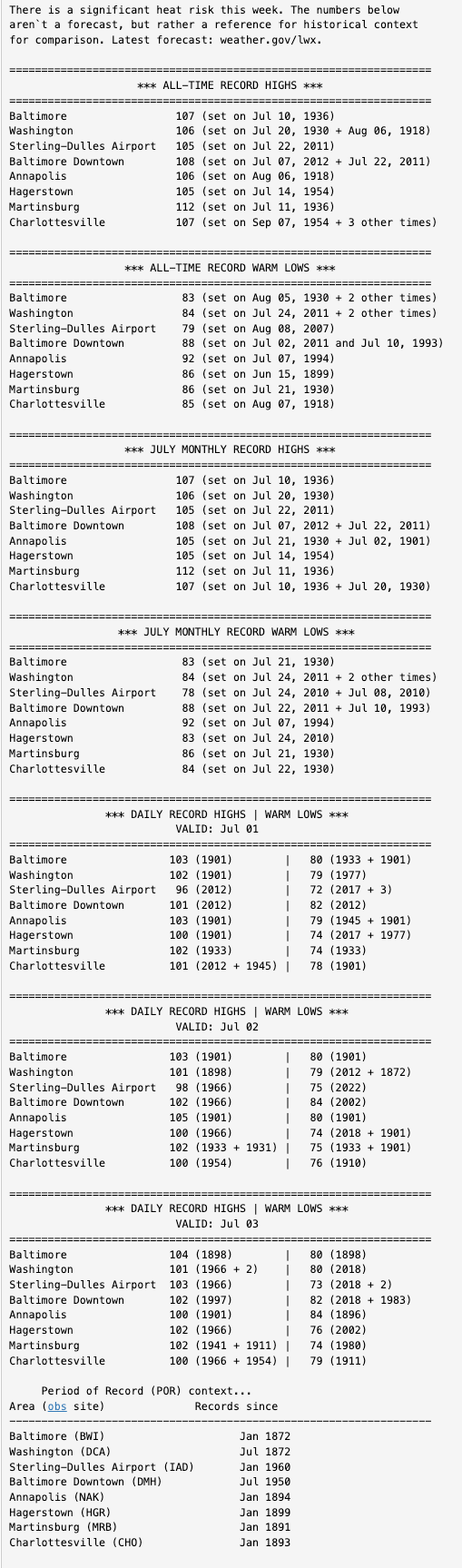
10:50 AM in Purcellville --> 89.9/79/106 --> It is thick outside - a wall of steamy madness!
-
Big Heat (and storms?) Week into July 4th Weekend
midatlanticweather replied to yoda's topic in Mid Atlantic
LWX Discussion had some good Climate Summary data
-
2026 Mid-Atlantic Severe Storm General Discussion
midatlanticweather replied to Kmlwx's topic in Mid Atlantic
https://x.com/bam_weather/status/2069093088639811884?s=20- 961 replies
-
- 1
-
-
- severe
- thunderstorms
- (and 7 more)
-
2026 Mid-Atlantic Severe Storm General Discussion
midatlanticweather replied to Kmlwx's topic in Mid Atlantic
Cell north of Culpepper looks interesting. -
2026 Mid-Atlantic Severe Storm General Discussion
midatlanticweather replied to Kmlwx's topic in Mid Atlantic
Mesoscale Discussion 1091 NWS Storm Prediction Center Norman OK 0202 PM CDT Thu Jun 11 2026 Areas affected...the Mid-Atlantic into southern New York and southwestern New England Concerning...Severe potential...Watch possible Valid 111902Z - 112100Z Probability of Watch Issuance...40 percent SUMMARY...Scattered thunderstorm development is expected this afternoon across the mid-Atlantic northward into southern New York and southwestern New England. Severe wind gusts and hail are possible with the strongest storms. DISCUSSION...Some deeper convective attempts are underway this afternoon across portions of the mid-Atlantic, particularly in southern New York as of 1900z. This development is occurring in a warm, unstable airmass with surface temperatures in the upper 80s and lower 90s F and MLCAPE values around 2000+ J/kg. The 18z ALB/Albany, NY sounding sampled the northern periphery of this airmass (along the CAPE gradient) with 0-6-km shear of 24 kts. This has supported some sporadic, more organized thunderstorm development recently. As the afternoon progresses, diurnal heating should support additional thunderstorm development across the region. Furthermore, a mid-level impulse in eastern OH -- influencing the ongoing convection in WW312 -- will continue moving eastward and should provide additional support for convective initiation and maturation. Bulk shear is expected to remain generally in the 15-25 kt range which, amidst forecast large MLCAPE around 2500-3000 J/kg, will promote strong updrafts capable of producing wind gusts and hail. Uncertainty remains as to how much convection will develop and coalesce/strengthen in the short term, but trends will continue to be monitored for possible watch issuance this afternoon. ..Flournoy/Gleason.. 06/11/2026 ...Please see www.spc.noaa.gov for graphic product... ATTN...WFO...OKX...ALY...PHI...BGM...AKQ...CTP...LWX... LAT...LON 39937855 42097738 42657579 42777436 42337326 41237290 40177310 37717495 37397648 37777765 38937842 39937855 MOST PROBABLE PEAK WIND GUST...55-70 MPH MOST PROBABLE PEAK HAIL SIZE...1.00-1.75 IN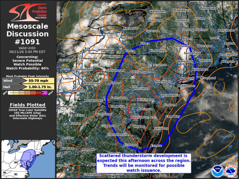
- 961 replies
-
- 1
-
-
- severe
- thunderstorms
- (and 7 more)
-
94 .. HI 108.. DP 78... Worst weather
-
Late May/June 2026 Medium/Long Range
midatlanticweather replied to JenkinsJinkies's topic in Mid Atlantic
Gfs wants to end the drought in the extended outlook. Tropical moisture could try.. I know it's way out and not right. -
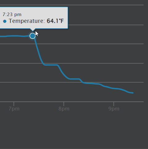
38.4 degrees for the low. No Frost but pretty cold
-
86.5 today was quite hot honestly. Not humid though. Watching the storms/rain progress slowly south.
-
Sleet and snow now in Purcellville. Mainly sleet Shall move to Discobs since it is not severe related from now on
- 1,093 replies
-
- 1
-
-
- severe
- thunderstorms
- (and 1 more)
-
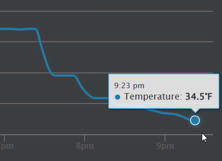
Down to 36 here in Purcellville. Windy and rainy
-
24.4 for a low. 25.5 currently
-
80 Degrees to Ripping Snow: March 12th
midatlanticweather replied to SnowenOutThere's topic in Mid Atlantic
Snow now and down to 36. -
80 Degrees to Ripping Snow: March 12th
midatlanticweather replied to SnowenOutThere's topic in Mid Atlantic
Basically, had a heavy shower that made things go to all sleet and even some slush balls, but as soon as it got lighter it went back to rain with some sleet and now just light rain with an occasional pinger. So, type of precip seems rate dependent which makes sense. Close to 38..was a bit cooler in the heavy precipitation -
80 Degrees to Ripping Snow: March 12th
midatlanticweather replied to SnowenOutThere's topic in Mid Atlantic
Rain mixing snow and sleet. 38.1 -
80 Degrees to Ripping Snow: March 12th
midatlanticweather replied to SnowenOutThere's topic in Mid Atlantic
41.9 here in Purcellville. Temp dropped 2 degrees the last 20 mins. It was 72 around 4am. Pretty dramatic changes -
80 Degrees to Ripping Snow: March 12th
midatlanticweather replied to SnowenOutThere's topic in Mid Atlantic
You must record it and share -
2026 Mid-Atlantic Severe Storm General Discussion
midatlanticweather replied to Kmlwx's topic in Mid Atlantic

-
2026 Mid-Atlantic Severe Storm General Discussion
midatlanticweather replied to Kmlwx's topic in Mid Atlantic
Spidy sense on that storm north of Luray. -
84.7 for a high. That is crazy. Ac was tested today
-
True! Just not ready for the heat!
-
81 in Purcellville! Hot and humid!