-
Posts
1,321 -
Joined
-
Last visited
Content Type
Profiles
Blogs
Forums
American Weather
Media Demo
Store
Gallery
Everything posted by Albedoman
-
March 12, 2022 Snow Discussion and Obs: Winter's Last Appearance?
Albedoman replied to Newman's topic in Philadelphia Region
You guys are hilarious. The snow is ripping, the yards and roads are caving, its trucking, a huge bag of wtf???? This clip best describes the current situation for you guys\\: -

March 12, 2022 Snow Discussion and Obs: Winter's Last Appearance?
Albedoman replied to Newman's topic in Philadelphia Region
to my fellow snow weenies LMAO . My sister in law just sent me this picture of whats coming our way a few minutes ago-- She lives in Memphis Tn. They already have thundersnow and the visibilities are pretty low. Notice the stickage on their streets and trees and by the way , it was 64 degrees yesterday there. -

March 12, 2022 Snow Discussion and Obs: Winter's Last Appearance?
Albedoman replied to Newman's topic in Philadelphia Region
alot of weenies going to be suprised tomorrow south of the LV. It will stick and accumulate. No sun angle here this time as temps fall and whiteout conditions become a problem with the winds. Bt Tuesday afternoon it will all be gone. -

E PA/NJ/DE Spring 2022 OBS Thread
Albedoman replied to Hurricane Agnes's topic in Philadelphia Region
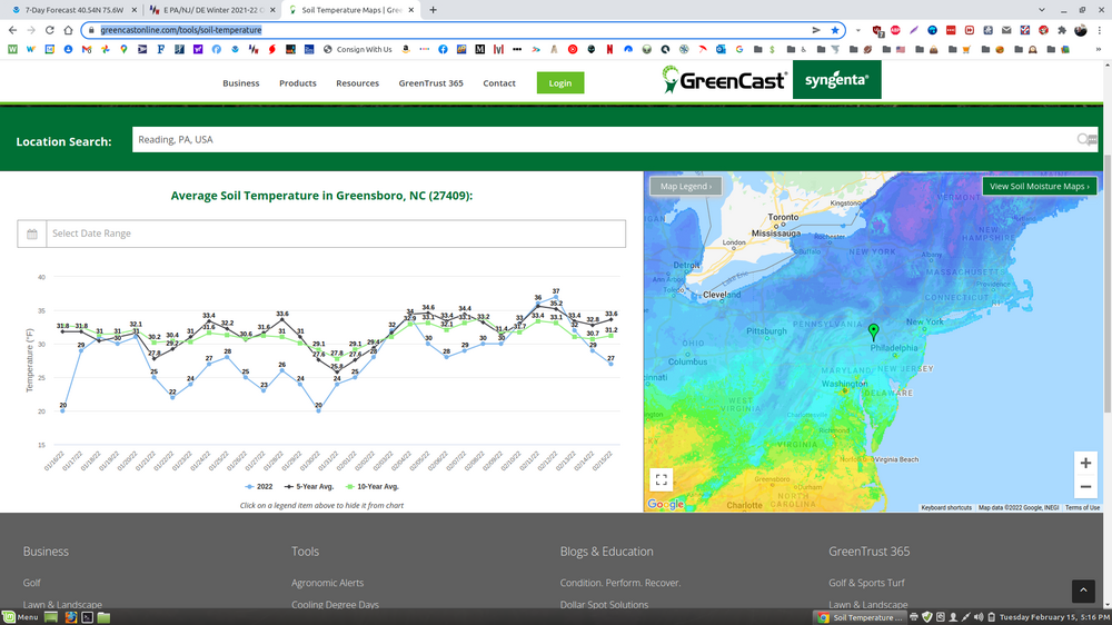
I know alot of you were ribbing the hell out of me about a drought. Well, this as in tonights paper and is why I am concerned: https://www.mcall.com/news/weather/mc-nws-us-expansive-drought-lehigh-valley-abnormally-dry-20220309-olkwcc5rtfcpjhck4nuozal6ai-story.html -

E PA/NJ/DE Spring 2022 OBS Thread
Albedoman replied to Hurricane Agnes's topic in Philadelphia Region
I say LV is the jackpot for tomorrows event. Would not be surprised if some areas hit six inches on the grass, especially near S Mtn and Blue Mts. At least half dollar size flakes will be nice to see -

E PA/NJ/DE Spring 2022 OBS Thread
Albedoman replied to Hurricane Agnes's topic in Philadelphia Region
wow, 73 + degrees today and the 0Z NAM is showing 4-6'' of snow for the LV on Wednesday. Wind gusts well over 45 mph. More freaking branches to pick up from the windiest last six months that I ever seen here. Not much rain however, less than .25 in. The predicted snow on Wednesday may help with some groundwater recharge for our area and keep the spring wildfires down as the ground is almost dry from tonight's northerly winds of 35 mph, even though it rained an hour ago. I also think a WWA may be issued for Wednesday. The snowfall rates appear to be pretty high and may actually accumulate on the road. 4 -6 inches of wet snow on the grass and 1-2 inches of white rain on the road appears to be reasonable expectation if the NAM/RGEM model is spot on. -

Feb 24-25th Event -- Generators for some, pre-emerg for others
Albedoman replied to JTA66's topic in Philadelphia Region
thanks anyway for the explanation -

Feb 24-25th Event -- Generators for some, pre-emerg for others
Albedoman replied to JTA66's topic in Philadelphia Region
thanks Mike. But the key here is the term "zones". Zones should be based on physical topographical delinations, not just by county lines or interstate highways. Since the late 80's - early 1990's the NWS started going from the airport offices and went to a regional based approached. I was one of the naysayers back then stated that regionalization of the NWS loses a much needed local perspective of topographical weather issues and places much more emphasis on computer modelogy and not the physical geography characteristics of the ridge and valley region of eastern PA, especially the LV. I really also do not like the idea of a county Emergency Manager setting the storm criteria as the they have no control of the federal and state highway system, PADOT does. Rt 22, Rt 309, Rt 100, Rt 33 and I-78 are the lifeline for the entire trucking industry and the LV residents in PA and I believe PADOT should have a say so at the table too. Cyrious, does each of the zones in Eastern PA being defined by physical geography or just political boundaries? How are these zones formed and what is the basis of each of these zones when assigning criteria for warnings and watches? That has never been really explained to me if you have the time? Again, Thank you for issuing the winter storm watch for Lehigh County by the way. -

Feb 24-25th Event -- Generators for some, pre-emerg for others
Albedoman replied to JTA66's topic in Philadelphia Region
the main problem , the criteria does not at all match the physical geography of PA, especially for the Lehigh and Northampton Counties. Weather is greatly dependent on physical geography, not the placement of interstates locations. Furthermore, It appears the Fall line is not in agreement with all criteria shown above. The warning criteria should have been set by the physical geographical feature of the Blue Mountains and not the Fall line since many of the specifications concerning satisfying the criteria of winter warnings and watches are very elevation driven and dependent too. Also, many readers of the discussion do not even know where the exact location of the Fall line actually is when mentioned in the discussion. My main gripe is that the winter storm watch/warning criteria for five inches is way too high for the LV which is the fastest growing area of state and as we are no longer rural. Four inches should be the level as that is when the municipal snow plows usually drop the blade and plow as well. The winter weather criteria should have been simply set at the Blue Mts. For the non- believers try going through the Lehigh Tunnel after a usual winter storm event - Snow heaven on the north side, brown grass on the Lehigh/Northampton county south side. Based on this weather pattern we are in, Mt Holly needs to revisit the criteria this summer and change it to a realistic determination, especially for elevation driven winter storm events. Consistency must be utilized if you are going to have a productive warning system in place. Right now, utilizing point forecasts as their driver seat is not working well in these type of weather forecast especially when frozen precip is ingested into the models that are fluctuating as much as they are today, its better to err and issue a winter storm watch. Using confidence levels is not forecasting IMHO, its simple gambling and utilizing computerized weather forecasts which are becoming the rule rather than based on true empirical science data, including physical geography. -

Feb 24-25th Event -- Generators for some, pre-emerg for others
Albedoman replied to JTA66's topic in Philadelphia Region
I absolutely disagree with todays MT Holly discussion. Again, with almost a million people in the Lehigh Valley metro area and the most heavily traveled truck corridor in the northeast, why are they being so laissez faire? When did weather forecasting become a non- physical geographical science? No where is the LV mentioned as having a even a potential significant ice accretions, yet the lower Delaware Valley and NJ is mentioned in the discussion as getting less than .1 of in of ice? You know , there are people who live north of the fall line and we are no longer in hicksville. Why is the LV split in half with a winter storm watch when the entire LV is covered by hills and mountains with many of the highest elevations along South Mountains in Lehigh County? I am so tired of the forecast discussions leaving out the LV region but being thrown in as an afterthought. Its time for a change guys as there are more people in the LV than in some states, We are geographically pinned by the Appalachian Mts on one side and South Mountains on the other side and the valley base elevations are hundreds of feet higher than even lower than Bucks County. PLease, Please, Stop talking about interstates as dividing lines for the types of precip but start talking about the mountain ranges. Man made - Interstates are being substituted for physical geography features. Stop dumbing it down. When you mention north of I-78, I-78 lies between two mountain ranges plus the interstate lies at the bottom of the Valley. If you are going to separate regions for precip amounts, please use South Mountains/Blue Mts or even the fall line as you basis for determining precip types, not 1-78. When in doubt , err on the cautionary side when issuing watches/warnings and list the entire Valley as a watch/warning. In otherwards, it physically does not snow and ice five inches in Bethlehem but not in Allentown since both cities border each other by one simple street. Do you even know that Lehigh University lies directly on top of South Mountain but both counties go through Lehigh University? Did you know that Salisbury Township in Lehigh County lies directly on top of South Mountain as well as Upper Saucon Township in Lehigh County? Did you guys know that huge PPL transmission lines cross the S Mountain and there are major electric substations located on this mountain range and that if the ice accretion on these facilities is severe, the power will go out for residents as far south as Telford PA? Its time for a visit out of the MT Holly office in NJ to see the physical geography of the LV when forecasting weather and not behind a computer screen looking up confidence levels. SHORT TERM /THURSDAY THROUGH FRIDAY NIGHT/... Really no significant changes to the forecast for the Thursday and Friday storm system as model agreement and consistency remain fairly strong. With this, we were able to issue a Winter Storm Watch for the northern parts of our forecast area where warning-level total snowfall is possible. This watch is in effect from 7 pm Thursday through 6 pm Friday. For other portions of the area, there is growing confidence for impactful freezing rain, but opted to refrain from issuing a watch for these areas with more advisory-level conditions likely. Will continue to message these concerns through the HWO and social media. Low pressure will track out of the Tennessee Valley and up the western side of the Appalachians into the headwaters of the Ohio over western Pennsylvania. With high pressure to our north over Ontario and Quebec, the warm front ahead of the system will remain mostly shunted to our south, though warm air will nudge northward as the front finally lifts through the Delmarva Peninsula Friday and a new coastal low forms over our area. The new 06Z run of the NAM has become a little more progressive and shifted north a touch with the storm, favoring the western parent low a little longer and spawning the new low over southern New Jersey rather than a little offshore. This slight shift kept enough uncertainty to not issue a watch any further south at this time. Continued to favor a Canadian and NAM blend for the low-level temperatures through this period to capture the CAD. QPF amounts remain steady so snowfall and ice amounts haven`t changed much with this new forecast cycle. With the slight northward shift, am thinking there may be a little more freezing rain rather than sleet over much of southeastern PA and central NJ. Other guidance sounding slam the higher terrain where the watch has been issued with heavy sleet Friday morning and early afternoon. Am not quite as confident in how far the freezing rain line will stall over our northern portions of the CWA, but think this may be around the I-80 corridor. A good thud of snow is likely to start the event as a weak vort max moves east along and north of the warm front. There may be a little lull before precip fills back in as the surface low moves closer from the west early Thursday night. Total snowfall amounts range from a few tenths of an inch over the urban corridor to 4-6 inches in the Poconos and Sussex County, NJ. Ice amounts still remain from one to two tenths of an inch across much of southeastern PA and into central New Jersey. These amounts area little lower over the Poconos and Sussex County, NJ with sleet and snow holding on a little longer in these places. Total liquid precipitation amounts range from a half to one inch south of Philadelphia to one to one and a quarter inches north of the city over the Lehigh Valley and into northern New Jersey. Travel will be impacted from the combination of wintry precip, especially Friday morning. Cannot rule out power outages and minor tree damage, but the system looks progressive enough that ice totals aren`t quite high enough for Ice Storm Warnings and those significant threats. && -

Feb 24-25th Event -- Generators for some, pre-emerg for others
Albedoman replied to JTA66's topic in Philadelphia Region
-
-
talking to my USGS buddies about the 10th St stream gauge in Allentown for the Little Lehigh. My flood thresholds were exceeded on Sunday and I emailed them to please check it out. This is what they found below . This is a first for me in my 32+ years here in the LV. All I can say it been really cold the last few days and if the snow pack was more pronounced , many areas would have been way below zero this morning. The recent" overachiever /over performer" snow event to the snow weenies was indeed dramatic for even in the locals in the Lehigh Valley. I went to Germansville/New Tripoli in northern Lehigh County this morning and there was barely a covering/dusting on the ground. 20 miles away at my house 4+ inches are still on the ground. Talk about localized snow banding. The site 01451500 was visited yesterday afternoon. While water temperatures remain above freezing, the air temperatures have dropped low enough to cause water within the orifice pipe to freeze and constrict air flow through the line. This constriction is pressurizing the line which results in erroneously high gage heights. This was first seen starting the night of Feb 5 and into Feb 6, but the cause for the erroneous gage heights was not known as the condition cleared itself and everything looked normal by the next scheduled visit on Feb 9. We expect the ice in the pipe to soon melt as daytime highs are forecast to reach 50F and nighttime lows will stay above freezing. Once able, measures will be taken to prevent such occurrences in the future.
-
yep. Realistically, both will contribute but as water sources become less efficient and ground water tables fall, fuel costs to transport rise dramatically as nearby water immediate well sources go off line as well as increased pumping costs for each well. It is not cheap to run the pumps deeper. Self imposed restrictions water withdrawal limits set by the company and as set by DRBC/PADEP permitting requirements for specific water withdrawals for each well will help contribute to the increase cost of production. You may want to ask Voyager as I believe he operates water tankers for a living.
-

2/13 Light/Moderate Snowfall Nowcasting & Observations
Albedoman replied to Northof78's topic in New York City Metro
blame the models on this one. It seems the models have forgotten about the LV this year and the effect of physical geography. -
No way. The snow falling now should be almost gone by Thursday and mostly by evaporation. However, a 2-3 inch long duration steady rainfall event would be real nice in early March as a drought buster when the soils are not frozen to the depth they are at right now and that would kill any chances of a drought. Just do not see this in this progressive pattern right now. This snow will be history by 9am as fast as this precip is moving.
-

2/13 Light/Moderate Snowfall Nowcasting & Observations
Albedoman replied to Northof78's topic in New York City Metro
I verify here in Macungie with death band over me. Hitting 5 in and still puking snow. NWS should issue a winter storm warning. Tree limbs really getting plastered. -
well, here it comes from the media- Its an "OVERPERFORMER" . Not one weather model predicted this type of lifting right now over us. Definite now cast event. we just got plain lucky with the location of death band in the LV. Well over 4 inches now approaching 5 inches and coming down at 1-2 in per hour. By 6am, should be well over 6 inches if this keeps up. Winter storm warning maybe issued? Its the most snow on the limbs that I have seen in over a year. real plasterer for sure.
-

Central PA - Winter 2021/2022
Albedoman replied to Bubbler86's topic in Upstate New York/Pennsylvania
4.2 inches in Macungie right now still puking snow. Best snow all winter. Nice snowman making snow- wet fluffy snow sticking to everything except the treated roads -

2/13 Light/Moderate Snowfall Nowcasting & Observations
Albedoman replied to Northof78's topic in New York City Metro
I am quite surprised. I have well over 3 inches of snow on the picnic table here in Macungie and on the grass right now, much less on the pavements. The best snowfall rates all year with fluffy half dollar size dendrites falling heavily. If this death band keeps going, we will have met winter storm requirements in the next few hours. Again, its about dam time it snows here this year instead of at the shore. -
I am quite surprised. I have well over 3 inches of snow on the picnic table here in Macungie and on the grass right now, much less on the pavements. The best snowfall rates all year with fluffy half dollar size dendrites falling heavily. If this death band keeps going, we will have met winter storm requirements in the next few hours. Again, its about dam time it snows here this year instead of at the shore.
-
yep, and salt water intrusion into the Delaware Bay becomes an issue as well. C'mon man. But really, the only one that will be laughing will be Nestle and Niagara as they raise the living hell out of the price for bottled water as they impose self restricted withdrawals from their water sources. Over 75% of the bottled water sold in our area comes from the water bottlers in the LV, including any Samuel Adams beer, Ocean Spray products and coke products


