HeadInTheClouds
-
Posts
1,691 -
Joined
-
Last visited
Content Type
Profiles
Blogs
Forums
American Weather
Media Demo
Store
Gallery
Everything posted by HeadInTheClouds
-

12/15 - 12/16 Coastal/Winter Storm & Observations
HeadInTheClouds replied to Northof78's topic in New York City Metro
33 and light rain now. -
12/15 - 12/16 Coastal/Winter Storm & Observations
HeadInTheClouds replied to Northof78's topic in New York City Metro
32 and light snow just started. -
12/15 - 12/16 Coastal/Winter Storm & Observations
HeadInTheClouds replied to Northof78's topic in New York City Metro
Hanging tough at 32 and overcast. -
12/15 - 12/16 Coastal/Winter Storm & Observations
HeadInTheClouds replied to Northof78's topic in New York City Metro
28 and cloudy. It's going to be interesting to see what happens here. I'm right on the Hudson in central Dutchess county about 10 miles north of Poughkeepsie and could get anywhere from near nothing to 6 inches or more if thermals are cold enough. -
12/15 - 12/16 Coastal/Winter Storm & Observations
HeadInTheClouds replied to Northof78's topic in New York City Metro
Yup. CMC/RGEM have been very consistent with downsloping/shadowing. American models not so much. It's a huge difference with only 24 hours before game time. -
12/15 - 12/16 Coastal/Winter Storm & Observations
HeadInTheClouds replied to Northof78's topic in New York City Metro
Big difference between GFS and CMC especially in HV..thumb.png.765f443bf647c69397310e24a199c98e.png)
.thumb.png.fcc3149cd495ac8f9e89fa3f7363c33e.png)
-
12/15 - 12/16 Coastal/Winter Storm & Observations
HeadInTheClouds replied to Northof78's topic in New York City Metro
00Z RGEM - a lot less and nearly nothing east of Hudson and it has been consistent with this..thumb.png.793689c2b74e8447397a63f57385cbe3.png)
-
12/15 - 12/16 Coastal/Winter Storm & Observations
HeadInTheClouds replied to Northof78's topic in New York City Metro
I think a lot will be determined by precip intensity at lower elevations. If it's heavy it could snow and when it is moderate or light it will rain. I still think Nam numbers are overdone at lower elevations. It will be interesting to see how things turn out. -
12/15 - 12/16 Coastal/Winter Storm & Observations
HeadInTheClouds replied to Northof78's topic in New York City Metro
Dacks just got named.thumb.png.96c0210e998a69ed732d5280ca8143b2.png)
-
12/15 - 12/16 Coastal/Winter Storm & Observations
HeadInTheClouds replied to Northof78's topic in New York City Metro
18z GFS won't back down with colder solution and higher snow amounts..thumb.png.3729a04ab6ec3dba9cfff6ca724ac8a1.png)
-
12/15 - 12/16 Coastal/Winter Storm & Observations
HeadInTheClouds replied to Northof78's topic in New York City Metro
Winter Storm Watch up in Orange county, obviously higher amounts expected in NW section and higher elevations. -
12/15 - 12/16 Coastal/Winter Storm & Observations
HeadInTheClouds replied to Northof78's topic in New York City Metro
Yeah, NWS Albany was talking about downsloping and shadowing in the valleys. I'll be happy with 2 inches before changeover. -
12/15 - 12/16 Coastal/Winter Storm & Observations
HeadInTheClouds replied to Northof78's topic in New York City Metro
12z Euro at 10:1. Kuchera map is not available on free Pivotal Weather so cut these amounts in half for our area..thumb.png.fad453d7fa54b3f6356dbac7fc6cfccf.png)
-
12/15 - 12/16 Coastal/Winter Storm & Observations
HeadInTheClouds replied to Northof78's topic in New York City Metro
.thumb.png.50119deb6f0f69b0dcc8e94aa917741e.png)
-
12/15 - 12/16 Coastal/Winter Storm & Observations
HeadInTheClouds replied to Northof78's topic in New York City Metro
GFS is on it's own little island of misfit toys. It is still colder and hasn't backed down on totals at 12z but I'm not buying it. I think we see no more than an inch or 2. -
12/15 - 12/16 Coastal/Winter Storm & Observations
HeadInTheClouds replied to Northof78's topic in New York City Metro
It's going to be very difficult to accumulate east of Hudson in the valley. I'm surprised Poughkeepsie is even that much..thumb.jpg.726106c4d46efdf89be95fdddbe33a4b.jpg)
-
12/15 - 12/16 Coastal/Winter Storm & Observations
HeadInTheClouds replied to Northof78's topic in New York City Metro
GFS says I'll see you and raise you 48 hours before start time..thumb.png.0e625589e28de45afc8c740e318ba19e.png)
-
12/15 - 12/16 Coastal/Winter Storm & Observations
HeadInTheClouds replied to Northof78's topic in New York City Metro
It's actually worse east of the Hudson..thumb.png.9ad84879cd6ce51e81466493d217ee91.png)
-
12/15 - 12/16 Coastal/Winter Storm & Observations
HeadInTheClouds replied to Northof78's topic in New York City Metro
.thumb.png.e1b55fe33fbdb24521fa75e130977937.png)
-
It does, plus clear skies and calm wind. Got down to 10 last night and right now 19.
-
12/15 - 12/16 Coastal/Winter Storm & Observations
HeadInTheClouds replied to Northof78's topic in New York City Metro
18z GFS still a colder solution..thumb.png.4eba9b88d0fab4777cee15c8bbe4fec9.png)
-
12/15 - 12/16 Coastal/Winter Storm & Observations
HeadInTheClouds replied to Northof78's topic in New York City Metro
It is colder which would have an impact on NW Jersey. I'm all for colder solutions. -
12/15 - 12/16 Coastal/Winter Storm & Observations
HeadInTheClouds replied to Northof78's topic in New York City Metro
18z Nam slightly warmer but still shows decent front end dump over interior but you need to be 50 miles N and W..thumb.png.c5835597ab3ad1425131049e121f3e3a.png)
.thumb.png.9c821d8140b69b80462cdd14713643be.png)
-
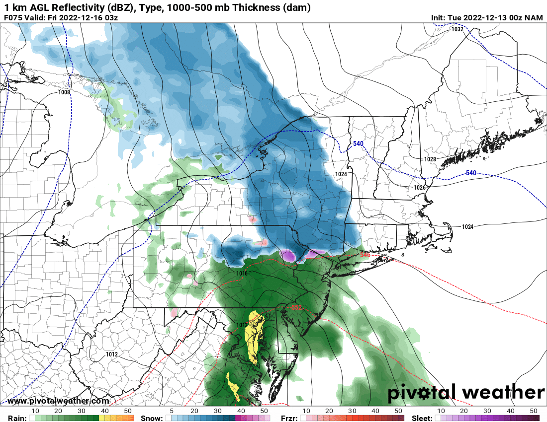
12/15 - 12/16 Coastal/Winter Storm & Observations
HeadInTheClouds replied to Northof78's topic in New York City Metro
Nam is a tad warmer but does have a front end dump N and W.
-
12/15 - 12/16 Coastal/Winter Storm & Observations
HeadInTheClouds replied to Northof78's topic in New York City Metro
It didn't look that different to me and it gives snow to places N and W.
.png.20b932e81abf90eb29171ee0f8f08e32.png)
.png.345a99499d79bcd2810638590e5fc032.png)

.png.4bdd18ca2d7e040e5c6948736c08a4fc.png)
.png.6ce0781ba6faa1b95dadd72a49bba73b.png)

.png.e281aaf3300463e55a18c6869cc86c5f.png)

.png.90da2c81b55eb7342bd941cf92b1a9a0.png)
.png.52cf96ca6d6f52ff751112e7e000e168.png)
.jpg.6033a3e4c894a0bc2fe8c8dede9568fd.jpg)
.png.5e35e55bd9c17b2de1834f72150a8f36.png)
.png.ed80851718158c7af1c9a42558837ee0.png)
.png.d9fe09b0cc9613081d59719d267db1eb.png)
.png.d01b5cdb50c6764bd42a2260a72b905a.png)
.png.f11e4c7ec0bfe75106904e71d590cabf.png)
.png.f4fc0d7ee3fc8c7d8fa75ac11da00ab1.png)