HeadInTheClouds
-
Posts
1,691 -
Joined
-
Last visited
Content Type
Profiles
Blogs
Forums
American Weather
Media Demo
Store
Gallery
Everything posted by HeadInTheClouds
-
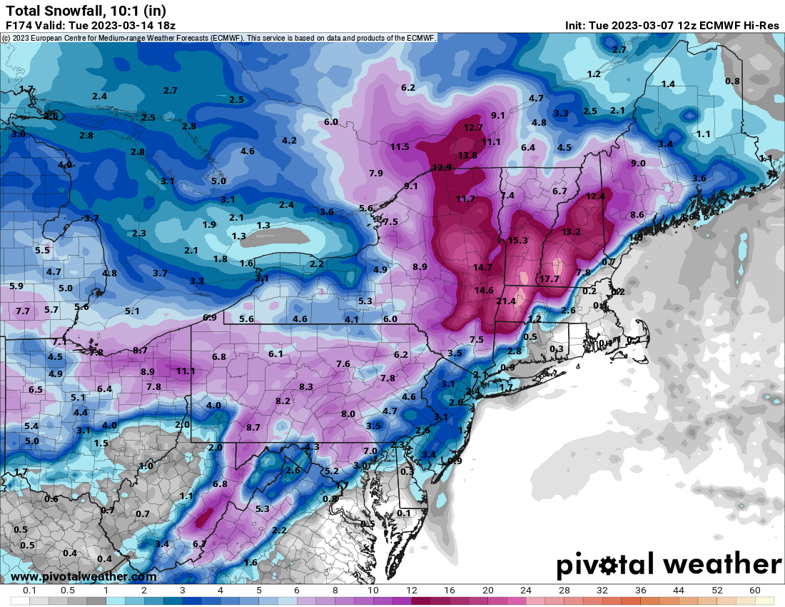
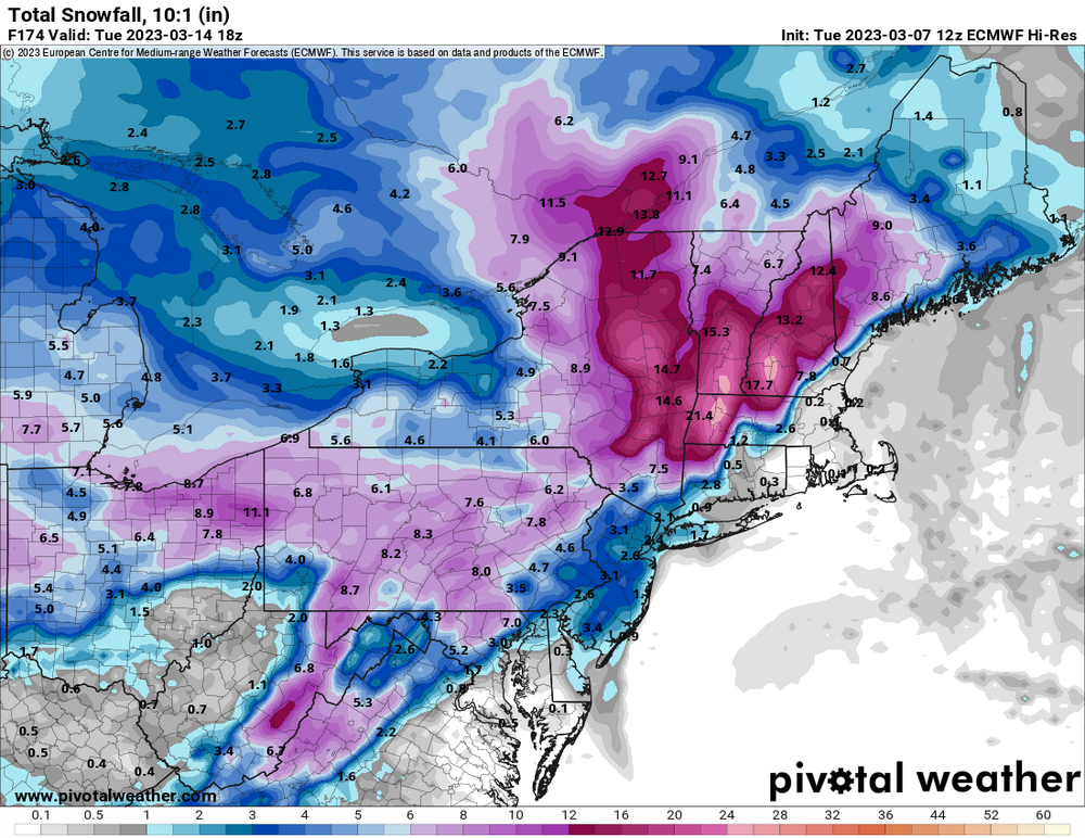
Can't be using 10:1 ratio maps in a marginal thermal event.
.thumb.png.c59215123e7cb299d06394cd68ededd3.png)
.thumb.png.faf170d0059472fbf93ab429cfceadc4.png)
-
18z Vs 12z is considerably more in northern areas. .5 vs .3 by me.
-
The CMC also shows a deepening coastal.
-
Both CMC and Euro are similar in terms of 2nd wave which is a coastal. GFS on it's own right now.
-
Wave 1 looks like a 1-2 inch type event for most and that's only because most precip falls at night. Wave 2 still a ways out but CMC looks similar to 00z Euro. Dicey at coast but interior would do well. GFS not impressed but will probably correct.
-
Disappointing model runs tonight with respect to 2nd wave.
-
That's not including all of the second wave. You have to go out further for northern areas. It still likely won't be accurate at 10:1.
-
That is incorrect, especially north of the city. If that particular scenario were to verify most of the precip would fall at night when temps were close to 30(especially around 84) so it would accumulate.
-
The models are struggling right now. Every model run is a different adventure. I don't think we start to see better consistency until mid week.
-
That's a low bar.
-
It's a terrible model all the time.
-
33 with a light mix. Picked up 1.5 inches of snow/sleet cement mix overnight.
-
33 and a major sleetfest
-
Down to 33, moderate snow, sticking on colder surfaces.
-
38 and snowing
-
I wouldn't count on it. When a cutter scenario shows up on both the GFS and Euro it's a red flag. I don't care if it's a week away.
-
Welp, next weekend went to shit pretty quick.
-
That blocking means business. March could be epic North of I90 and central and Northern NE. I think areas south get some of the goods also including NYC metro.
-
Yes, I think they do. They just changed it back to 5-8 but still ridiculous. NWS Albany just went 1-2 from 2-4.
-
50 today. NWS forecast for 1-2 tomorrow night then mixing which is reasonable. Weather channel app has me 8-12 tomorrow night up from 5-8, lol. GFS does have me getting 11 but we know that will not verify.
-
Yeah, expecting 2-4 inch front end dump up here north of 84 before mixing. It could come down pretty hard for a few hours.
-
He also said winter was definitely over since December.
-
33 and still snowing pretty good but looks like it's almost over.
-
28, steady light snow, 6 inches
-
30 with moderate snow, 2.5 OTG.

.png.28834e454dad7ce0b58bb70a1a59feb6.png)
.png.d70387a433b816afce1a5a346fd567e8.png)