

HeadInTheClouds
-
Posts
1,691 -
Joined
-
Last visited
Content Type
Profiles
Blogs
Forums
American Weather
Media Demo
Store
Gallery
Everything posted by HeadInTheClouds
-
I have some left also. It looks like we get dry slotted and then when precip picks up again it quickly turns to rain. Still moderate snow here but not much longer.
-
34 and moderate snow, sticking on colder surfaces. Today has the same look as Monday when we picked up 1.5. I'm not sure we even get that much this time.
-
That would be funny and cruel at the same time. @MJO812would be on suicide watch.
-
It's a good model, better than Nam. I'm just saying it's not always right and has some bad moments.
-
32 with moderate snow. Coating on colder surfaces. The great Rgem had me not getting a flake until after 18z.
-
Schools closed again today. They were also closed on Monday when we got a whole 1.5 inches. Right now 33 and light snow just started.
-
Most other models give me (20 miles north of I84) between 1.5 and 3, not unreasonable. Nam does give me close to 4 which is probably too much.
-
Consistent doesn't always mean correct though. Cmc/Rgem have had their bad moments also. It gives me .5 inch and it has for days. It's wanted nothing to do with a front end dump all the way to Albany. The last time it showed that when other models showed differently it turned out to be correct.
-
It's very unimpressed with the front end snows but we will see if it is right. It has me getting .5 inch up here and every other model has 2-4.
-
33 and still some last gasp moderate snow. Just about 1.5 mainly on colder surfaces. 6.5 for the season.
-
33, moderate snow, 1 inch of wet snow so far
-
I get on them for cancelling school sometimes but I can kind of understand it with the timing today. It's coming down, expected to continue until mid afternoon, and roads can get slippery and the buses cover a large area. Back in my day I used to walk miles to school in the snow uphill both ways. They just don't make them like they used to.
-
33 with heavy snow. Schools were cancelled today.
-
33 with light/moderate snow. Sticking to colder surfaces.
-
37 with rain/snow mix. nasty out.
-
Nobody in NW NJ and mid hudson valley is seeing anywhere near those totals. Poughkeepsie area is maybe 1-2, Albany area is 3-6. Only places seeing 6+ are Catskills, Helderbergs, Berkshires and places well north.
-
Your elevation may help but I think most of Orange, Putnam, Dutchess crew see an inch, max 2. I think tonight is rain/snow mix and it depends on whether the period of snow on the backend tomorrow morning is legit.
-
Central Florida and NYC have had the same amount of snow this winter.
-
We need CPcantmeasuresnow on the case.
-
I mentioned Catskills because you said elevated far N and W. I don't consider Sussex and Putnam counties far NW from NYC. As far as where the storm will impact the most I agree with everything you said, especially about I-84 corridor Fishkill-Beacon area. Southern Dutchess county definitely could go either way. I think Poughkeepsie on north sees 1-2.
-
Elevated N and W expecting more than a little, Catskills expected to get 5-8. Valleys should also get some snow, anywhere from 1-2 in MHV to 3-6 up towards I90.
-
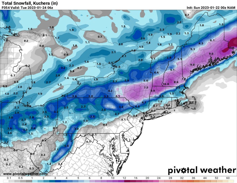
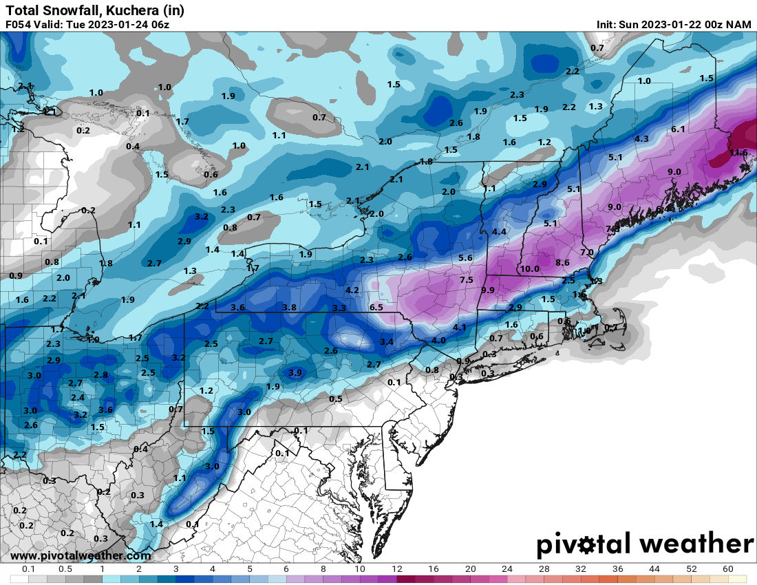
This is 10:1 which won't verify in this situation with marginal thermals. Best to use kuchera which would show lower ratios.
-
Nam and Rgem. A few inches for mid HV and pretty robust amounts around I90.
.thumb.png.b93c0d1fa1191a6abb05bfc4c3ea74f9.png)
-
Don't pat your self on the back just yet.
-
I would say it doesn't look good for NYC metro and coast for Sunday night/Monday. Hell, it's dicey for me north of 84 where it's looking like snow/rain.


.png.39bf6229b1639fdbb385d30cb5dea67a.png)