

BTRWx's Thanks Giving
-
Posts
3,209 -
Joined
-
Last visited
Content Type
Profiles
Blogs
Forums
American Weather
Media Demo
Store
Gallery
Posts posted by BTRWx's Thanks Giving
-
-
I'm kind of glad I didn't get an interview to work at WPC now. I will pray for those affected!
-
2 hours ago, Kmlwx said:
I'll shut up after this...but there's clearly trying times ahead and in progress for the science communities in all fields. But we as a forum do *not* have to let ourselves tear each other to pieces. We are all entitled to our opinions - and we should understand that you are very unlikely to change somebody's mind these days. All you will end up doing is wasting finger strength typing and getting your blood pressure up.
It's very clear to me that a certain percentage of this forum are just going to absolutely let the world "climate" these days just destroy them inside and out no matter what. We can be better than this and it's why the mods and management have asked us to steer clear of the "that" topic.
Above all - and even despite some of the frankly horrid post tones I've seen on here in the past day or two, we are better than this as a forum. Many of us have been here since the Eastern days and many of us even before that. I would like to hope that we are all still those same people who rang with giddy child-like energy when snow was pouring down outside our windows in the big dog storms.
I'll call some people out but all in good natured fun...but I remember @DDweatherman - taking a video of maybe pea sized hail or smaller and absolutely just losing his shit. I still chuckle about that video to this day (at least I think it was him!). @mappy - and I sort of came into our forum days around the same time so I'll always have that bonding point with her (my weenie tag era...). @Wxtrix may have her detractors over the years, but frankly my experience is that towards me, at least, she was never anything but welcoming and kind. Rich Hitchens (who was a member here) actually crossed paths with me when I asked for an interview for my high school paper - years before we figured out we were both posting here/and on Eastern....I miss that dude. Rich, Dave (for those that know Dave), and I had an inside joke from the conferences years ago that always gave us a chuckle. @Ian - while he was still posting here was a staple of the forum for years. For those of us that attended conferences, who can forget Wiz dressing up as Hannah Montana and doing the worm in front of the Marriott in Baltimore in front of a drunk wedding party. And good lord @yoda has been a rock in my weather world for years...I just can't get rid of that dude @Eskimo Joe has got to be the most endearing deb I've ever had the amazing misfortune of acquainting myself with (i say that in the most loving way lol). @H2O - how could I even write a single dig about that dude. @Maestrobjwa - We've clashed at times but you've never once told me to GTFO (you probably have wanted to countless times). And at this point - can't imagine this subforum without you! @Ji and @Stormchaserchuck1 - You both will probably hate being grouped together...but ya'll are the ones everyone loves to hate. @stormtracker - What the hell is there to say about you? You freaking made it so a bunch of weather nerds could hole up in a hotel MULTIPLE times in a row and get wasted and be totally obnoxious guests...you've started countless inside jokes, you've ruled with what I think is a ridiculously fair gavel....I mean hell...you never banned me even in the 2009-2011 period...and good lord you made it so that many of us could MEET IN THE FLESH....people like Paul f'ing Kocin (and many more). We were able to walk among some of our idols with your help....and some of those times literally felt like the cheesy scenes in a movie like Field of Dreams to me. And those aren't memories I will forget until my brain is mush.
I left a ton of people I am very fond of out of that little ode above (and know that it's only because it was haphazardly and quickly written as word vomit)...but my bottom line here is that you can disagree with me...but the friendships that we have forged as a forum should easily be able to make it through whatever we are going through as a forum, country, and world.The amount of vile messages being posted here is just really sad to see. Maybe I'm just too naive as a person and maybe I just see too much good in people - but even the folks that people love to hate on in here - I've generally found a way to "make it work with" - with maybe an exception or two.
We cannot let any of this F up what we have built here. It's not worth it to lose years of friendships. We've already lost members on here for health or age reasons...time flies too fast. Whether there's snow on the ground or not - it costs nothing for us to keep a little oasis of civility while the world seemingly burns around us. We can absolutely do this. But we all need to work together.
So I ask that even if you can't keep it up - we all at least TRY to think before we post. Maybe take the edge off your messages if you re-read them and you just need to make them a little less vile. It can't hurt to do a quick read through.
Weather has been formative to such big chunks of many of our lives...we'll get through this.
Thank you!
-
 1
1
-
-
19 minutes ago, pazzo83 said:
"i just want to get away from the politics on this board!!". YOU FUCKERS MADE IT POLITICAL.
The issue is the layoffs to NOAA aren't even political.
-
1 minute ago, Demeter said:
That’s better than I thought it would be.
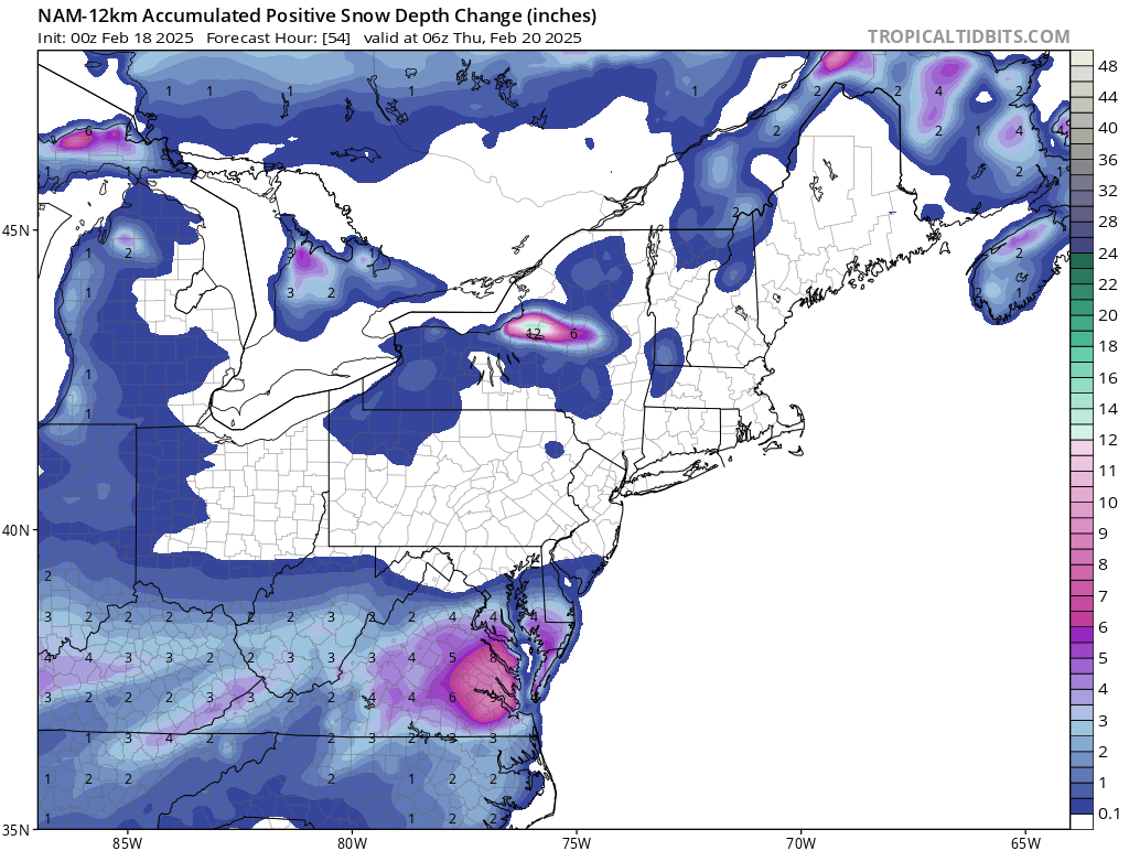
There was a little more after the map I shared. https://www.tropicaltidbits.com/analysis/models/?model=namconus®ion=neus&pkg=asnowd&runtime=2025021800&fh=63
-
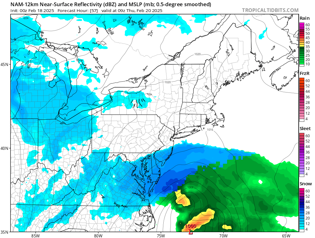
Why are people upset about this? https://www.tropicaltidbits.com/analysis/models/?model=namconus®ion=neus&pkg=ref_frzn&runtime=2025021800&fh=54


-
 2
2
-
 1
1
-
-
The NAM still has some accumulating snow inside the beltway.
-
1 minute ago, StormyClearweather said:
I think it takes a lot less for Buffalo to get a good snow than it does for us, so in that way, sure. But I think anything that's well outside the norm (such as a major snowfall is for us) has a lot more room for error, because so many things have to come together for it to happen, usually. All Buffalo needs is a cold front with a westerly wind over a non-iced lake, etc. etc.
My extended family lives north of Buffalo. The way they are squeezed between the two lakes, their forecasts bust often.
-
Last 4 runs

-
4
-
-
1 minute ago, stormtracker said:
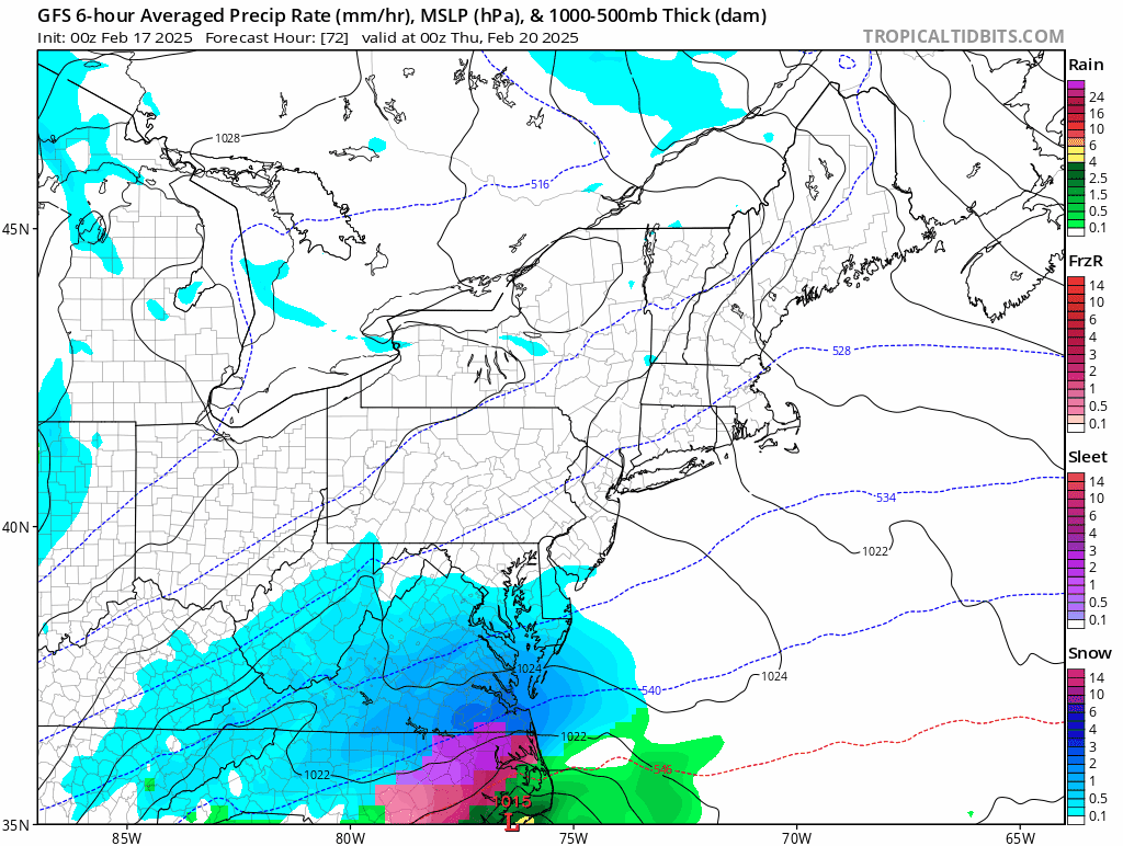
Yeah, nothing like the NAM. Of course
The low is east of NC instead of GA at hour 54.
-
1 minute ago, CAPE said:
Its amazing that the NWSFO never mention the ICON, let alone factor it in to their forecasts. Makes you wonder.
BTW there is a WSW up for OC. Heading down?
They are smart about it.
-
7 minutes ago, Conway7305 said:
Is there any chance this storm comes back NW or unlikely and keeps ticking SE?
Nobody knows.
-
Who is responsible for this thread?
-
 1
1
-
-
You will never be a meteorologist if you wish-cast the outcomes you want.
-
Stop ignoring bad outcomes!
-
 1
1
-
-
7 minutes ago, Weather Will said:
You don't want to see it.
Yes I do
-
Can someone please post the eps?
-
-
Any word on the eps?
-
5 minutes ago, baltosquid said:
12z GEFS for the first time in a bit makes a decided trend SE/drier.
Have a map?
-
3 minutes ago, Snowman. said:
If there's one model that I can trust to score a coup its the Euro. Not saying it's gonna happen, but you never know.
I am.
-
3 minutes ago, rjvanals said:
It's crazy we're ~100 hours out with such a wide range of outcomes
Nobody ever learns.
-
1
-
-
2 minutes ago, bncho said:
It may be the last FOLKS until December 2025. Enjoy it.

This is a very good place to be 4 days out! Forget the other models at this range!
-
I would argue that the euro op is better than the gefs at this range, and the gfs even less so.
-
Just now, NorthArlington101 said:
Kuchera is friendlier

That's great to see 4-5 days out with ensemble support!
March Medium/ Long Range
in Mid Atlantic
Posted
Didn't he say it wouldn't be cold this winter when it actually was?