cardinalland
-
Posts
516 -
Joined
-
Last visited
Content Type
Profiles
Blogs
Forums
American Weather
Media Demo
Store
Gallery
Everything posted by cardinalland
-
 been analyzing radar/models and i seem to be thankfully east of the line of fire in new haven… we’ll probably still end up with 2-3” rain though
 -
it also comes down to the rates and training. i remember our Ida flood really came out of a 3 hour stretch where it was raining buckets… if more spread out it might not be as bad
- 886 replies
-
- 1
-

-
- heavy rain
- flooding potential
- (and 2 more)
-
if the 12k nam is right i might have to buy a boat
-
Wake Me Up When September Ends..Obs/Diso
cardinalland replied to 40/70 Benchmark's topic in New England
should i be worried about flooding in new haven? models seem all over the place on the heaviest rain axis -
it seems like south central connecticut is a screw zone for this storm… would be sad if it was a snowstorm but we don’t really need more rain. Storm totals so far: 0.41” at KBDR bridgeport, 0.43” at KHVN new haven
-
an “impressive” 0.43” storm total so far at new haven airport
-
Wake Me Up When September Ends..Obs/Diso
cardinalland replied to 40/70 Benchmark's topic in New England
2021 was wild. peak leaf was mid-november in new haven -
this could have similar impacts to a nor’easter for much of eastern new england. i don’t expect to get more than a little fringe rain here in new haven though
-
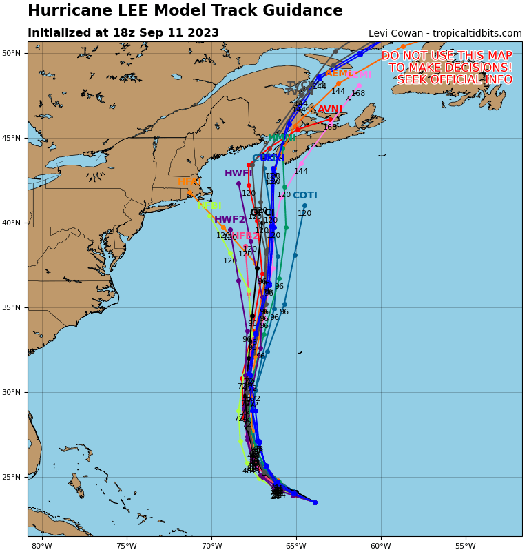
i think tropical tidbits goes a little farther and shows the HAFS-B / HFBI just south of nantucket at the end

-
a lot of these tracks in the GFS/GEFS remind me of Henri 2021 but stronger and more to the east. kind of an odd/rare track though
-
a significant contingent of 18z GEFS members have that west hook. the low pressure is at 39N 69W at hour 144
-
Wake Me Up When September Ends..Obs/Diso
cardinalland replied to 40/70 Benchmark's topic in New England
tired of not having AC 82/75 currently -
good on you for calling them out. the amount of outright wrong claims about this hurricane online/on social media are ridiculous… people saying “a category 5 is coming for nyc”… i’ve never seen it this bad
-
The 00z intensity was 155mph i wonder if they keep it at that or bring it to Cat 5
-
idk i heard it’s gonna hit miami new orleans and new york as well
-
i’m getting 1903 vagabond hurricane vibes from this one
-
an interesting complication is that a slower/more south storm may have more time to be pulled northeast by a trough, as opposed to a faster moving storm. the 18z GFS kind of shows how this could happen
-
einstein was wrong about quantum randomness but i wish i would’ve gotten the chance to speak with him as well
-
Newark hit 97, highest temperature there of the year so far
-
12z Euro: trough and ridge are both significantly west of 00z
-
this GFS run is also quite a bit slower, storm has already made landfall by that time in Canada on the last run
-
Euro/CMC OP have a very different evolution than GFS OP approaching hour 240. Euro/CMC OP have a stronger 2nd tropical disturbance off to the east and not much of a high south of Newfoundland, while the GFS has a strong high south of Newfoundland and no 2nd tropical disturbance. An out-to-sea solution seems more supported to me but I'm still keeping an eye on this one for east coast from NC to Newfoundland Edit: Also wanted to add that as usual things might become more clear once the storm has actually fully formed
-
lots of storms have been intensifying up to landfall recently and the northeast GOM is quite hot/above normal unfortunately
-
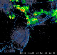
bonkers lightning on the UWS
-
lol