cardinalland
-
Posts
508 -
Joined
-
Last visited
Content Type
Profiles
Blogs
Forums
American Weather
Media Demo
Store
Gallery
Everything posted by cardinalland
-
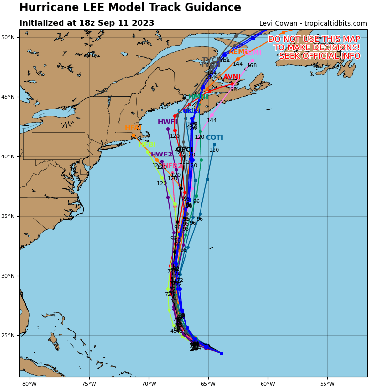
i think tropical tidbits goes a little farther and shows the HAFS-B / HFBI just south of nantucket at the end

-
a lot of these tracks in the GFS/GEFS remind me of Henri 2021 but stronger and more to the east. kind of an odd/rare track though
-
a significant contingent of 18z GEFS members have that west hook. the low pressure is at 39N 69W at hour 144
-

Wake Me Up When September Ends..Obs/Diso
cardinalland replied to 40/70 Benchmark's topic in New England
tired of not having AC 82/75 currently -
good on you for calling them out. the amount of outright wrong claims about this hurricane online/on social media are ridiculous… people saying “a category 5 is coming for nyc”… i’ve never seen it this bad
-
The 00z intensity was 155mph i wonder if they keep it at that or bring it to Cat 5
-
idk i heard it’s gonna hit miami new orleans and new york as well
-
i’m getting 1903 vagabond hurricane vibes from this one
-
an interesting complication is that a slower/more south storm may have more time to be pulled northeast by a trough, as opposed to a faster moving storm. the 18z GFS kind of shows how this could happen
-
einstein was wrong about quantum randomness but i wish i would’ve gotten the chance to speak with him as well
-
Newark hit 97, highest temperature there of the year so far
-
12z Euro: trough and ridge are both significantly west of 00z
-
this GFS run is also quite a bit slower, storm has already made landfall by that time in Canada on the last run
-
Euro/CMC OP have a very different evolution than GFS OP approaching hour 240. Euro/CMC OP have a stronger 2nd tropical disturbance off to the east and not much of a high south of Newfoundland, while the GFS has a strong high south of Newfoundland and no 2nd tropical disturbance. An out-to-sea solution seems more supported to me but I'm still keeping an eye on this one for east coast from NC to Newfoundland Edit: Also wanted to add that as usual things might become more clear once the storm has actually fully formed
-
lots of storms have been intensifying up to landfall recently and the northeast GOM is quite hot/above normal unfortunately
-
bonkers lightning on the UWS
-
lol
-
We’ll probably some 90s in the tri state area today or tomorrow. KBDL near hartford is forecast to hit 91 today
-
4.8” in new haven at 11am. flurries now
-
4.1” in new haven, still moderate snow
-
2.8” in New Haven. moderate snow
-
just hit 2” in new haven, snow has lightened up in the last 20 minutes. started at 9:30
-
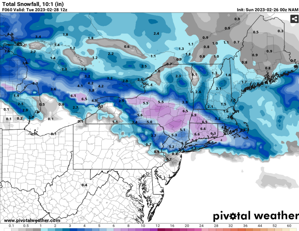
I feel like usually in close range NAM is a little north and GFS is a little south, regardless. and the reality is somewhere in the middle (at least in the past few years of storm tracking) this is completely anecdotal but it gives some idea of an upper and lower bound for me
-
Interesting gradient in NYC on the models - although in my experience from when I lived in NYC, that usually doesn't hold, and a changeover to rain around JFK is usually soon followed by a changeover to rain or at least sleet in Manhattan/Bronx
-
NAM at 63 hrs (rain-snow line has moved to Putnam county by this time). Totals will be lower due to mixing/low ratios near the coast