CheeselandSkies
-
Posts
3,369 -
Joined
-
Last visited
Content Type
Profiles
Blogs
Forums
American Weather
Media Demo
Store
Gallery
Everything posted by CheeselandSkies
-

4/25-4/28 Severe and Heavy Rain Threat
CheeselandSkies replied to Geoboy645's topic in Lakes/Ohio Valley
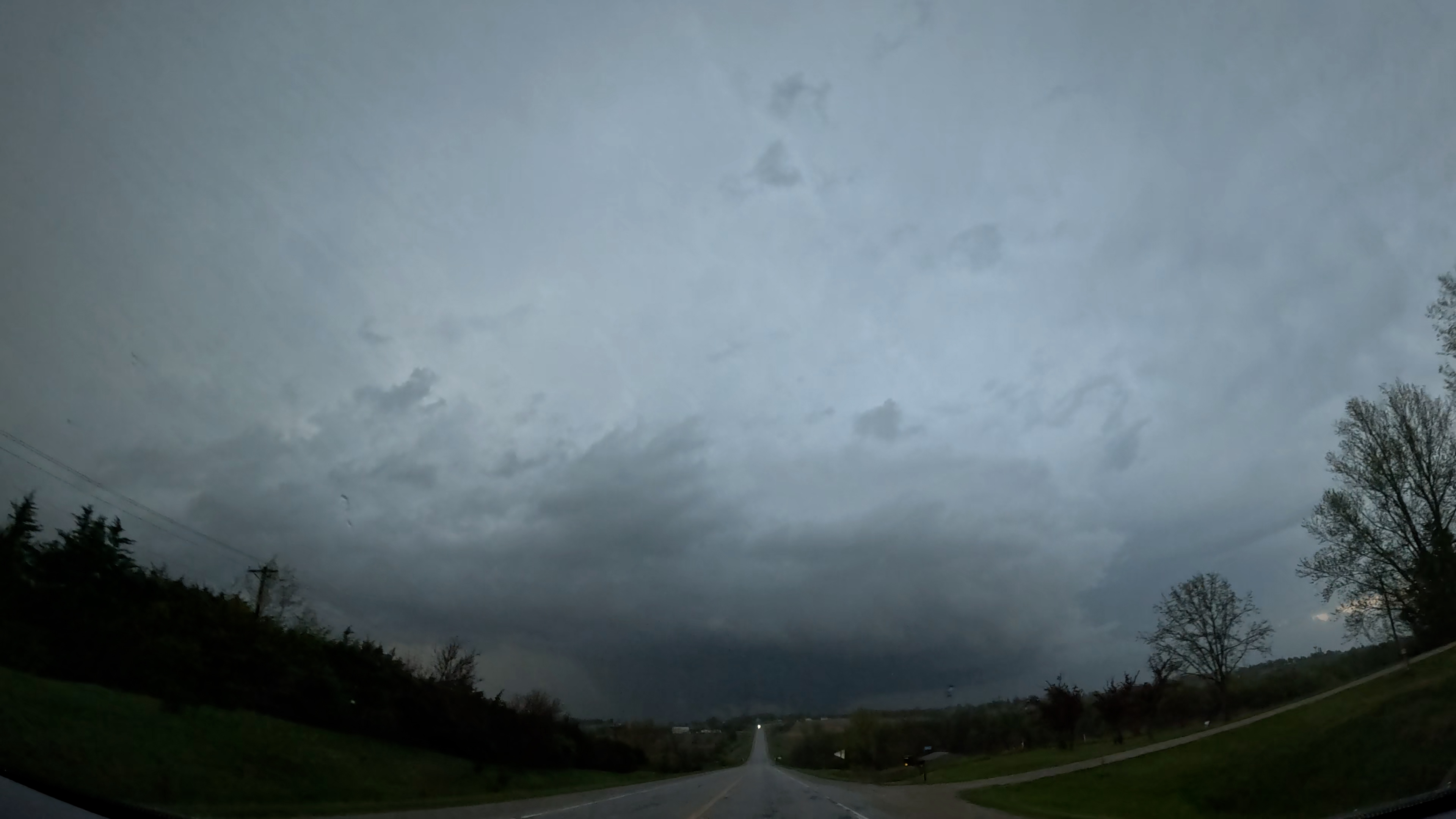
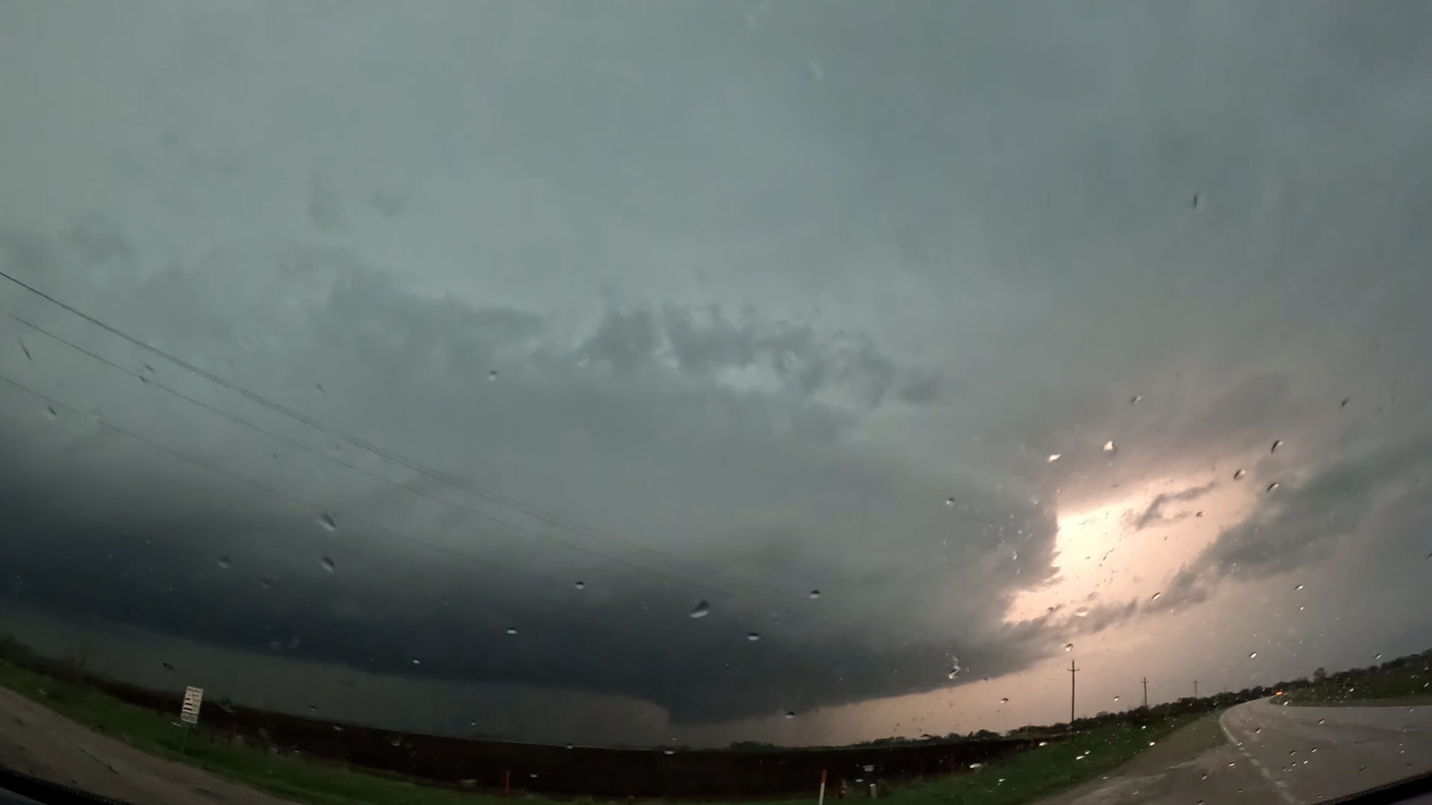
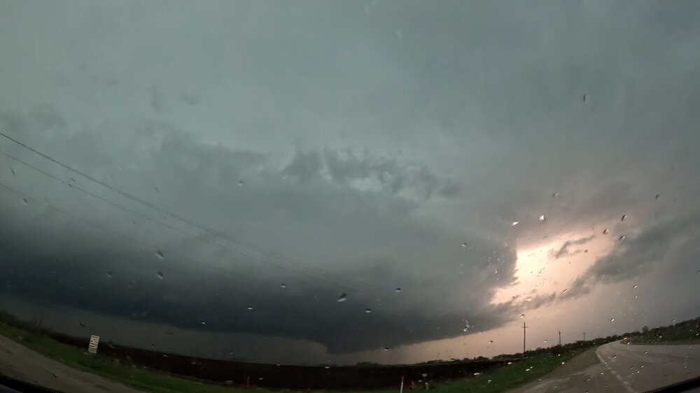
Great shots! I am still scratching my head as to how I managed to be in pretty much the same area at the same time and get jack squat for quality shots. I was on the storm that produced the initial Creston tornado when it first went tornado-warned southwest of Bedford, and observed this nice wall cloud just west of IA-148: Taking 148 north through Bedford, I had to drive practically underneath it to get to my next east option. It was here that road options quickly became an issue, as I became trapped in a maze of unpaved roads trying go as fast as possible without sliding off as the base outran me and started producing. With some white knuckle driving I managed to make it back to pavement and emerge onto US-169 just east of Shannon City, a little ahead of the longitude of the couplet according to RadarScope. Blasting north and cresting a hill near Arispe at 7:34 (per timestamp of cell phone pictures I took which did not turn out through the raindrop-spattered windshield), this was my view ahead. One of those lowerings under the base is surely the first Creston tornado, but which? Hindsight being 20/20 I should have taken a left instead of a right where 169 intersects US-34 and then I would have easily been able to see the second tornado. Instead I pursued the original cell to north of Lorimor and by the time I finally got a good view under the base, the tornado had lifted. Hills and trees to the southwest obscured my view of the base of the second cell; so noting that it was also tornado-warned with an intense couplet I viewed this more as something to avoid getting run over by rather than try to see. I followed the base of the original cell a little further to the northeast, IIRC it later produced additional tornadoes but I broke off due to darkness rapidly setting in. I went back to 169 and found a spot that looked to be clear of the path of any couplets to pull over and wait out the RFD with blinding rain and strong, but fortunately not too crazy winds to clear the highway before heading north to Winterset and then toward home.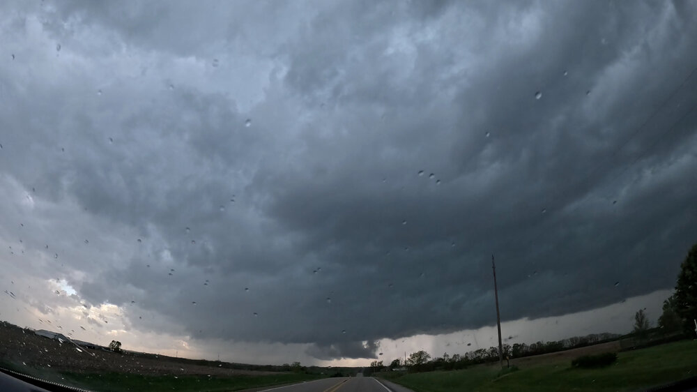

-
0Z has it as well, somewhat further NW and with a secondary EHI max near the Quad Cities.
-
2024 Short/Medium Range Severe Weather Discussion
CheeselandSkies replied to Chicago Storm's topic in Lakes/Ohio Valley
Euro and to a lesser extent GFS have the left exit region punching right into southern WI/northern IL at 0Z Wednesday, but GFS has already put the front through with the best moisture shunted south/east. If the GFS's slightly too fast bias holds here, that could give those areas higher potential at the expense of IN/OH. Of course, my backyard bias is at play here since I'll be back home next week, but also back at work. Sent from my Pixel 8 using Tapatalk -
4/25-4/28 Severe and Heavy Rain Threat
CheeselandSkies replied to Geoboy645's topic in Lakes/Ohio Valley
I pulled up GR Level 3 about 6:30 and saw what appeared to be a bona fide supercell taking shape near Monticello tracking east. I grabbed my cameras and loaded them into the car; right as I was doing so is when the tornado warning went out. I had redemption for bungling yesterday's southwest Iowa chase on my mind. Not to be as by the time I got to where I would have had a view of the updraft base, the storm had essentially ceased to exist. Currently getting some nice boomers back at the house in Madison. -
Severe Weather 4-25 through 4-28-24
CheeselandSkies replied to cheese007's topic in Central/Western States
I think a little of both. However, to my point below; each potential threat recently has had some obvious limiting factors apparent in the model data within a few days out (moisture depth, wave timing, etc). I was under the impression that we were actually currently moving out of El Nino toward neutral and then La Nina (hence also the universally very high-end forecasts for the Atlantic hurricane season)? *** The models showing a big, amplified trough with moisture is one thing; however, details matter. Most of the prior setups this year have had significant caveats become apparent within the 3-5 day range. However the amateur social media hypelords either didn't know or didn't care to point them out. @andyhb is right, this one is not downtrending to any degree that I'm seeing. If anything; each subsequent model run is only reinforcing the idea that the ceiling is quite high and something significant could happen each day starting tomorrow through Sunday. Now, will it? Not necessarily, but confidence it's higher than it's been in quite some time IMO. -
2024 Short/Medium Range Severe Weather Discussion
CheeselandSkies replied to Chicago Storm's topic in Lakes/Ohio Valley
Couple of 1" hail reports in western Lower MI; nothing came of this elsewhere. -
2024 Short/Medium Range Severe Weather Discussion
CheeselandSkies replied to Chicago Storm's topic in Lakes/Ohio Valley
Sneaky marginal risk over SE WI/NE IL/NW IN/W lower MI today. Sent from my Pixel 8 using Tapatalk -
April 16-17 Severe Weather Event
CheeselandSkies replied to nwohweather's topic in Lakes/Ohio Valley
That tornado wasn't photogenic for very long but you sure made the most of it! -
April 2024 General Discussion
CheeselandSkies replied to PositiveEPOEnjoyer's topic in Lakes/Ohio Valley
Apparently record low (24) set at Dubuque today. Didn't think we were in any kind of noteworthy cold pattern for doing that. -
April 16-17 Severe Weather Event
CheeselandSkies replied to nwohweather's topic in Lakes/Ohio Valley
Our @hlcater got some of the better footage I've seen of the tornado of the day (at least duration/impact-wise) which tracked from Houghton-Mediapolis, IA. Me, I was on the storm minutes beforehand but didn't think it looked about to produce and jumped on the southern storm, which was also tornado-warned at the time, and chased it across the river to near Little York, IL but it never did much of interest. Wall cloud looking west on 140th St., south of Houghton or near Mt. Hamill: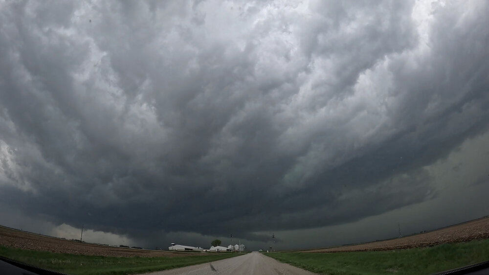
-
2024 Short/Medium Range Severe Weather Discussion
CheeselandSkies replied to Chicago Storm's topic in Lakes/Ohio Valley
Pretty sharp dry slot pushing into SW IA/NW MO. Not a lot of lingering cirrus behind the first round. HRRR back on board with firing a second round after dropping it for a run here or there (notably the 0Z yesterday evening). -
2024 Short/Medium Range Severe Weather Discussion
CheeselandSkies replied to Chicago Storm's topic in Lakes/Ohio Valley
True. -
2024 Short/Medium Range Severe Weather Discussion
CheeselandSkies replied to Chicago Storm's topic in Lakes/Ohio Valley
And of course, 0Z HRRR now cap busts SE IA despite a pretty sexy parameter space. I don't necessarily buy it given how much forcing ought to be present, but not exactly what I was hoping to see. -
2024 Short/Medium Range Severe Weather Discussion
CheeselandSkies replied to Chicago Storm's topic in Lakes/Ohio Valley
Yeah, picture is becoming *a bit* clearer. Pretty much all 18Z CAMs agree on robust supercell development in a solid parameter space, most in the far SE IA vicinity (3KM NAM a little further west). Looks like it's going to be another drive to Mt. Pleasant, IA and evaluate kind of day, need to be more decisive than I was on 4/4/23. Getting my cameras charged... -
2024 Short/Medium Range Severe Weather Discussion
CheeselandSkies replied to Chicago Storm's topic in Lakes/Ohio Valley
Tomorrow certainly going to be very interesting...ought to be at least a couple strongsomewhere near the IA/IL/MO intersection. As to exactly where in that vicinity at this point... Picking a target on 3/31 last year was easy (except the morning of when the HRRR started to make western IL look really good; but fortunately I came to my senses). This is giving me unpleasant vibes of 4/4 when I sat in Mt. Pleasant just long enough to miss both the Pleasantville and Table Grove/Lewistown storms. Ended up going for the latter but was stuck on the wrong side as it coalesced and went tornado-warned, so I just threw in the towel and started driving for home. A chaser I've been acquainted with for a long time and long held in high regard was in a similar situation (probably only about 10-15 minutes ahead of me out of Mt. Pleasant), tried to core-punch to get a view, and ended up having a very bad time of it so I'm glad I didn't do that. -
2024 Short/Medium Range Severe Weather Discussion
CheeselandSkies replied to Chicago Storm's topic in Lakes/Ohio Valley
Hey, I kind of am. I grew up on '90s TWC tornado docs with tons of footage from 4/26/91 since it was THE recent major outbreak of record at the time (as well as one of the first, along with 3/13/90, to take place in the camcorder era with a lot of home tornado video, although still nothing like now when everyone's phone can record 1080p or 4K video). I like to armchair chase a good Plains outbreak if I'm not able to chase it myself. I stay the **** off social media, though. It's long been a wretched hive of scum and villainy and it's only getting worse. 4/26/91 was also considered a major coup for the comparatively primitive NWP of the time; but I now believe it could just as easily have gone the way this one has. It was just "luck" from a forecasting standpoint that a lot of meteorologists called for a major outbreak based on what they saw several days in advance, and it verified. -
2024 Short/Medium Range Severe Weather Discussion
CheeselandSkies replied to Chicago Storm's topic in Lakes/Ohio Valley
The forecast surface pattern for Tuesday afternoon/evening looks pretty darn near ideal for a significant mid-to-upper MS Valley severe weather outbreak (much as it was on 3/31 last year) and I'm seeing many NAM forecast soundings with large 3CAPE values and strong low-level shear; however there are some caveats. - Most of those NAM soundings also have very wonky wind profiles above 700mb, with sharp backing to due southerly at 500mb followed by veering again but weakening at 300mb. - 18Z GFS wipes out instability across IA/IL with a huge amount of ongoing convection throughout the day. This is likely overdone; but still a legitimate potential fly in the ointment. -
2024 Short/Medium Range Severe Weather Discussion
CheeselandSkies replied to Chicago Storm's topic in Lakes/Ohio Valley
IMO, the hype for 4/2 was the stupidest thing I've ever seen in the era of social media weather "forecasting." There was nowhere near the model consistency or agreement on a high-end tornado outbreak; and the trough geometry was totally different than either of the two Super Outbreaks and most of the other known top-tier violent outbreaks. SPC may have inadvertently fueled it by outlining the 15% hatched -driven moderate risk. There are some forecasters there who seem to tailor their outlooks to the "worst-case scenario" rather than the most likely. I disagree with this, but if they feel that's the best way to fulfill their mission to protect lives and property, that's fine. -
2024 Short/Medium Range Severe Weather Discussion
CheeselandSkies replied to Chicago Storm's topic in Lakes/Ohio Valley
From the 13Z outlook. Doesn't sound like the kind of wording that should accompany an Enhanced/10% contour. -
April 2024 General Discussion
CheeselandSkies replied to PositiveEPOEnjoyer's topic in Lakes/Ohio Valley
Decent rain here going to work on those snow piles; should see an explosion of greenery within a few days. -
April 8 Great American Eclipse forecast
CheeselandSkies replied to DLMKA's topic in Lakes/Ohio Valley
Eclipse forecast seems to have improved for my area. Now looking at "mostly sunny" according to MKX. -
I mean, it only goes 24 hours out so you wouldn't have the 10 days of hype. I will say, the simulated reflectivity for the late evening Alabama supercells (that produced Guin, Tanner 1+2, Jasper and Redstone Arsenal) looks somewhat less impressive than I would have expected. Around 02Z-03Z when those storms would have been peaking, it just looks like strung out line segments in the northwest corner of the state, not monster supercells producing some of the most violent tornadoes of what stood as the most prolific tornado outbreak on record for 37 years.
-
Shows how the 500mb setup for this outbreak was completely different than the one for Tuesday of this week and why the Super Outbreak comparisons to that were silly. To really get those high-end outbreaks you need to see those very wide E-W, neutral to moderately negatively tilted troughs with a broad area of SW-WSW (not SSW) 500mb flow in the exit region spreading out into the warm sector.
-
Spring/Summer '24 Banter and Complaint Thread
CheeselandSkies replied to IWXwx's topic in Lakes/Ohio Valley
Was bored so threw this together using my storm footage across the years over the music video to Van Halen's "Humans Being" from the Twister soundtrack. -
4/2-4/3 Significant Late-Season Snowstorm (WI/MI)
CheeselandSkies replied to Geoboy645's topic in Lakes/Ohio Valley
God that April sucked. And coming just 4 years after 2014 which similarly had a much BA pattern locked in for the first 6-8 weeks or so of "spring," I was really afraid that was the new normal.