Silver Meteor
-
Posts
241 -
Joined
-
Last visited
Content Type
Profiles
Blogs
Forums
American Weather
Media Demo
Store
Gallery
Everything posted by Silver Meteor
-
The most snowfall ever recorded in a single winter in Maryland was during the winter of 2009–10, when 262.5 inches of snow fell at Keysers Ridge.
-
January 30th- Feb 1st ULL and coastal storm obs
Silver Meteor replied to JoshM's topic in Southeastern States
Storm chaser in Greenville, NC: -
January 30th- Feb 1st ULL and coastal storm obs
Silver Meteor replied to JoshM's topic in Southeastern States
Here in Greenville, NC I suspect we're going to beat the all-time record of 13" set in 1896. -
The “I bring the mojo” Jan 30-Feb 1 potential winter storm
Silver Meteor replied to lilj4425's topic in Southeastern States
Greenville, NC blizzard-like conditions here at 11pm. Snow & blowing snow with at least a foot on the ground. Couldn't open the front door of my apartment building because it was blocked by a drift. Quite insane over here. -
The “I bring the mojo” Jan 30-Feb 1 potential winter storm
Silver Meteor replied to lilj4425's topic in Southeastern States
YouTube storm chaser in Greenville, NC -
January 30th- Feb 1st ULL and coastal storm obs
Silver Meteor replied to JoshM's topic in Southeastern States
OMG such a nightmare! I feel so sorry for you folks, truly I do. -
The “I bring the mojo” Jan 30-Feb 1 potential winter storm
Silver Meteor replied to lilj4425's topic in Southeastern States
For Eastern NC that looks great. Problem is ... I DON'T BELIEVE IT. -
The “I bring the mojo” Jan 30-Feb 1 potential winter storm
Silver Meteor replied to lilj4425's topic in Southeastern States
Greenville, NC was consistently a "jackpot" area with even the NWS forecasting 8-12" ... now what, 2 or 3 inches? Total fail by the coastal Low (unless it tracks WEST all day.) Good grief. -
The “I bring the mojo” Jan 30-Feb 1 potential winter storm
Silver Meteor replied to lilj4425's topic in Southeastern States
I've seen 50 years of nor'easters on the Mid-Atlantic coast ... this thing is a f'kn joke. Low is not coming up from the south (Miller A) it's just forming offshore the Carolina coast (near 200 miles out initially and is only now reforming closer but not close enough) with a miserable QPF shield. Watched it all on the Ventusky website and knew those of us relying on the coastal were going to underperform. NWS has already reduced the snow totals for Greenville, NC by 3" and may not be done yet. UGH. https://www.ventusky.com/wind-speed-map/10m-above-ground#p=33.81;-76.82;6&w=0xIAb9A9A -
The “I bring the mojo” Jan 30-Feb 1 potential winter storm
Silver Meteor replied to lilj4425's topic in Southeastern States
Would have much preferred a Miller A storm moving up along the coast. For a coastal Low hitting Arctic air this is a joke. -
January 30th- Feb 1st ULL and coastal storm obs
Silver Meteor replied to JoshM's topic in Southeastern States
THAT'S OLD. Use the time settings at the bottom of the screen. (Low is well offshore. Too far for my liking.) https://www.ventusky.com/wind-gusts-map/1-hour#p=33.20;-79.78;6&w=0xIAb9A9A -
The “I bring the mojo” Jan 30-Feb 1 potential winter storm
Silver Meteor replied to lilj4425's topic in Southeastern States
The weak Low moving near the S.C. you refer to has since stretched out and is now in the process of reforming notably farther offshore, probably where it was supposed to form. Notice the tropical feed here at 2:30am. https://www.ventusky.com/wind-speed-map/10m-above-ground#p=31.8;-76.5;5&w=0xIAb9A9A -
The “I bring the mojo” Jan 30-Feb 1 potential winter storm
Silver Meteor replied to lilj4425's topic in Southeastern States
Yep... https://www.ventusky.com/?p=30.61;-80.05;6&l=gust&w=0xIAb9A9A -
The “I bring the mojo” Jan 30-Feb 1 potential winter storm
Silver Meteor replied to lilj4425's topic in Southeastern States
Here you can see the vortex forming east of Savannah. Doesn't look all that far out to sea. https://www.ventusky.com/wind-gusts-map/1-hour#p=32.38;-78.00;6&w=0xIAb9A9A -
The “I bring the mojo” Jan 30-Feb 1 potential winter storm
Silver Meteor replied to lilj4425's topic in Southeastern States
GFS for Thursday, Feb 5th.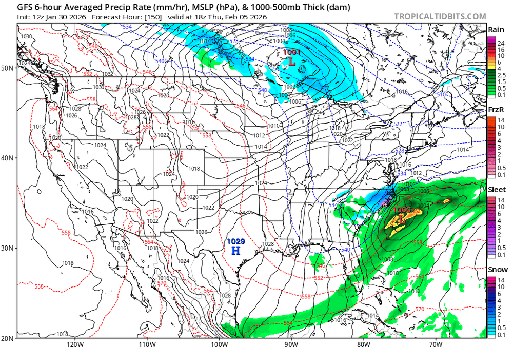
-
The “I bring the mojo” Jan 30-Feb 1 potential winter storm
Silver Meteor replied to lilj4425's topic in Southeastern States
Would appreciate anyone posting that image so I can save it (and share it with my friends up north.) -
The “I bring the mojo” Jan 30-Feb 1 potential winter storm
Silver Meteor replied to lilj4425's topic in Southeastern States
I'd laugh but being in Pitt County (Greenville) that's too close for comfort at this stage of the game. -
The “I bring the mojo” Jan 30-Feb 1 potential winter storm
Silver Meteor replied to lilj4425's topic in Southeastern States
Twenty three years in Eastern N.C. (am a central Md. native,) and have yet to break the 4" barrier with snow. Either I've cursed the places I've lived in here (ILM/PGV) or it's awfully damned hard to get a decent snow in Eastern, N.C. BTW, what's the blue hand palm in your profile image? It seems to be popping up here and there lately and I've no clue what it is. -
The “I bring the mojo” Jan 30-Feb 1 potential winter storm
Silver Meteor replied to lilj4425's topic in Southeastern States
Look at your own profile ... zero hint as to where you're located. Those who don't show their city and state are irritating. Worse yet at those who show only their zip code as if we're all supposed to know? Narcissists much? -
The “I bring the mojo” Jan 30-Feb 1 potential winter storm
Silver Meteor replied to lilj4425's topic in Southeastern States
GFS also shows an all time record snowfall for the Cape Fear area. -
The “I bring the mojo” Jan 30-Feb 1 potential winter storm
Silver Meteor replied to lilj4425's topic in Southeastern States
Greenville, NC keeps flipping from 3" to 12+" from model to model and run to run. This needs to stop because I'm becoming bipolar. -
The “I bring the mojo” Jan 30-Feb 1 potential winter storm
Silver Meteor replied to lilj4425's topic in Southeastern States
Wilmington and Myrtle ... what a hoot! -
The “I bring the mojo” Jan 30-Feb 1 potential winter storm
Silver Meteor replied to lilj4425's topic in Southeastern States
This is not the first time I've seen that modeled gap between Raleigh and the Coast. Greenville less snow than anyone? What the hell is going on! -
The “I bring the mojo” Jan 30-Feb 1 potential winter storm
Silver Meteor replied to lilj4425's topic in Southeastern States
Now we're talk'n. Oh Canada! -
The “I bring the mojo” Jan 30-Feb 1 potential winter storm
Silver Meteor replied to lilj4425's topic in Southeastern States
7.8" for Greenville? You gotta be kidding me. These are some weird totals for a coastal storm.