Paleocene
-
Posts
2,050 -
Joined
-
Last visited
Content Type
Profiles
Blogs
Forums
American Weather
Media Demo
Store
Gallery
Everything posted by Paleocene
-
Yep, my house is oriented facing north, and my front yard still has snow. Shady parts of the backyard too - at least a few inches. We lost a lot of snowcover yesterday around the neighborhood, but I'm looking at possibly 25+ days of snow on the ground in at least a few spots. Some kind of recent record, for sure
-
I bet a small portion of my winnings from the eagles-comms matchup on the bills. Big mistake. Chiefs don't lose in the playoffs, and certainly not to the Bills. Disappointing - as an eagles fan, I'm deeply sorry to everyone who has to watch us play the Chiefs again. Boring! Wish it were birds vs bills. Battle of the most degenerate fanbases. 4 out of the last 6 super bowls == eagles or niners versus chiefs!!!
-

January Medium/Long Range: Chasing more snow to close out the month
Paleocene replied to mappy's topic in Mid Atlantic
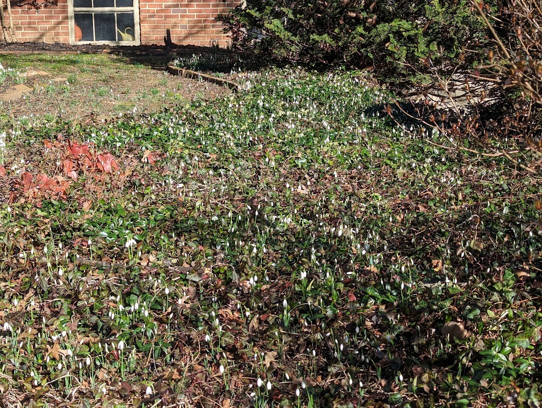
Alright. I'm on the hunt. Nothing beats the power of the UHI. I will find a snowdrop by 10 days from now and post it here by or before 2/6/25 -
January Medium/Long Range: Chasing more snow to close out the month
Paleocene replied to mappy's topic in Mid Atlantic
Here's a pic of a small field of snowdrops in my neighbor's yard in zip code 20910 (downtown Silver Spring and surrounding nhoods). Date Stamp: 2/4/24. I have another pic of crocuses from 2/2/23. Barring very cold conditions in the next 7-10 days, I will be able to find a bunch of flowers like these in my nhood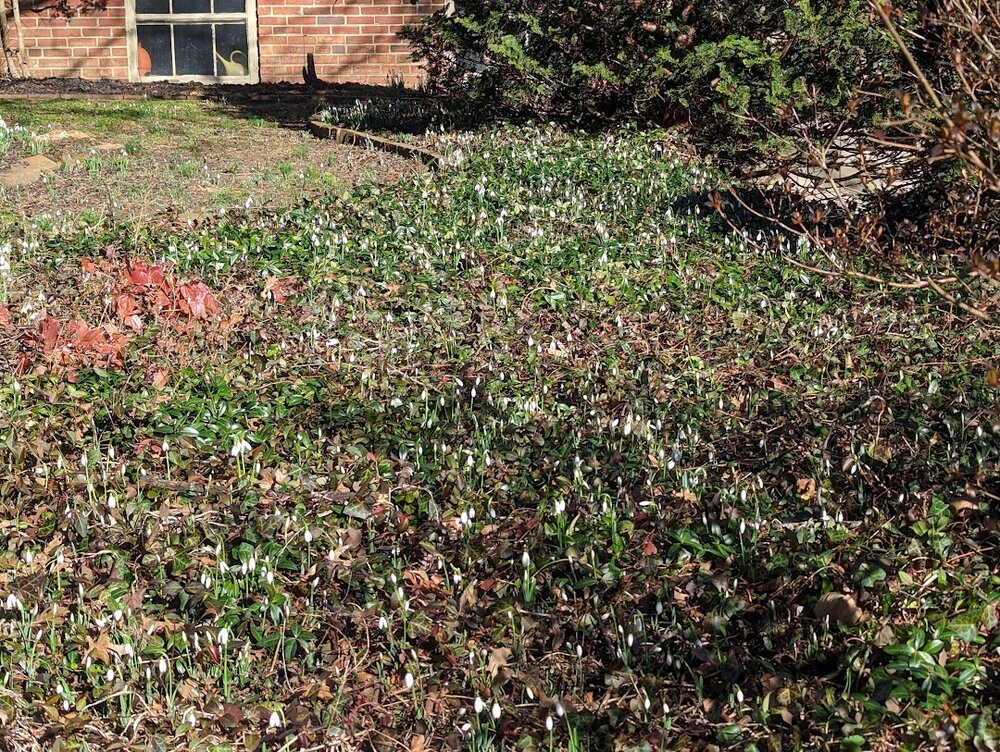
-
January Medium/Long Range: Chasing more snow to close out the month
Paleocene replied to mappy's topic in Mid Atlantic
Yeah, that's a fair point. Wonder if any red-taggers know. I imagine the degree of departure is related to the probability in some way -
January Medium/Long Range: Chasing more snow to close out the month
Paleocene replied to mappy's topic in Mid Atlantic
CPC nailed our cold snap, so no reason to not trust them. Break out the shorts, get ready for crocuses and snowdrops here in the UHI -
All in good fun, I'm just a lifelong psycho eagles fan, all family from Philly. Awesome to see the NFC east duking it out for the NFC title. Daniels is legit.
-
Dan Quinn can't wait control his scrub defense, GO BIRDS
-
Obviously the Potomac River next to the airport has the same microclimate as Annapolis next to the bay.
-
January Medium/Long Range: Chasing more snow to close out the month
Paleocene replied to mappy's topic in Mid Atlantic
-
January Medium/Long Range: Chasing more snow to close out the month
Paleocene replied to mappy's topic in Mid Atlantic
LOL is this banter or long range? Entire page about the eagles - commies game -
January Medium/Long Range: Chasing more snow to close out the month
Paleocene replied to mappy's topic in Mid Atlantic
https://en.wikipedia.org/wiki/January_1998_North_American_ice_storm I was in PA at the time, and we had school cancelled because the ice was predicted to hit PA too. It didn't. My brother and I stayed inside and played Goldeneye N64 with our friends -
I drove back to DC from PA on Monday, on 15/270. There was a steep fall-off once one got south of Frederick headed toward Rockville.
-
January Medium/Long Range: Chasing more snow to close out the month
Paleocene replied to mappy's topic in Mid Atlantic
Sign me up for the apocalyptic ice storm. -
January Medium/Long Range: Chasing more snow to close out the month
Paleocene replied to mappy's topic in Mid Atlantic
Thanks for the reminder that I was in Takoma Park at that time. -
Same in moco.
-
I remember getting 40+ inch NAMings in the 72 hour leadup to that storm
-
In the annals of terrible management of schools, this just in from Montgomery County Schools MD. They had previously (tues evening) called a two hour delay for Thursday, in advance. Now, they have cancelled that. Good News! Thanks to better-than-expected road conditions and the outstanding efforts of MCPS staff to treat and clear ice from our school sites, we’re excited to announce that Montgomery County Public Schools will operate on a Code Green schedule with normal operations on Thursday, Jan. 23, 2025. Please exercise caution in your travels and dress appropriately for the cold temperatures. Important Note: All MCPS school-sponsored activities, including athletics and community use of schools, will also proceed as scheduled this evening, Wednesday, Jan. 22, 2025. While this reversal of our decision may cause some confusion, this is truly an MCPS Moment of Joy, as we look forward to returning to the energy and excitement of full-time teaching and learning!
-
Sucks to be in this area. Not often the snowcover looks like this from GOES16
-
I know there are lots of OBX appreciators on this subforum -- lots of good cams from everyone's favorite spots here: https://www.surfchex.com/cams/hatteras-web-cam/ Dunes are snow covered! https://islandfreepress.org/hatteras-island-features/hatteras-and-ocracoke-island-winter-storm-of-2025-in-photos-part-1/
-
Montgomery County Public Schools in MD just pre-emptively called a two hour delay for tomorrow and Thursday.
-
SN+ on bourbon street. https://www.earthcam.com/usa/louisiana/neworleans/bourbonstreet/?cam=bourbonstreet
-
Snowcover, on the beach, in Galveston TX. https://www.galveston.com/webcams/surfvideocam/ Pretty cool!
-
January Medium/Long Range: A snowy January ahead?
Paleocene replied to mappy's topic in Mid Atlantic
Gfs spit out record snowfall for Jacksonville FL... Cool -
1/19 - The Roulette Wheel 29 Black Storm - OBS
Paleocene replied to DDweatherman's topic in Mid Atlantic
Great storm up in Harrisburg. Probably 6" of fluffy big dendrites. Light, not accumulating stuff all morning til mid afternoon. Snowed hard from about 2pm-6pm. Excellent deform band stuff. Back to the snow hole tomorrow