Wintersnow888
-
Posts
172 -
Joined
-
Last visited
Content Type
Profiles
Blogs
Forums
American Weather
Media Demo
Store
Gallery
Everything posted by Wintersnow888
-
Spring/Summer 2022 Medium/Long Range Forecast Discussion.
Wintersnow888 replied to John1122's topic in Tennessee Valley
I agree on being ok with highs in 60s. My grandfather always talked about the little winters here on the plateau, dogwood first I think,and woolen britches winter and whippoorwill winter and I think blackberry winter is around the end of May when blackberries are in bloom. Someone else in the thread may have mentioned this already -
Leading edge just came through
-
Spring/Summer 2022 Medium/Long Range Forecast Discussion.
Wintersnow888 replied to John1122's topic in Tennessee Valley
Any chance they're wrong and we might get more? Probably the last snow anyway... -
Rain coming down hard and we have gotten some pretty strong cracks of lightning and thunder, should be heading everyone else's way east of me
-
Thinking the gust front just came through, but it wasn't very strong, dogs are freaking out though
-
Never cleared out here in Cumberland, sky has noticably gotten darker in last 2o minutes and cloud layer lowering.... starting to hear thunder
-
March 11th-13th Winter Weather Event. Winter's last gasp?
Wintersnow888 replied to Windspeed's topic in Tennessee Valley
Noticed the NWS has lowered our temp highs for the next few days. They had 60s and have now posted high 40s because of snow. Anyone else notice it in their areas? -
March 11th-13th Winter Weather Event. Winter's last gasp?
Wintersnow888 replied to Windspeed's topic in Tennessee Valley
Wind has definitely been a factor all night, final band very gusty. It's knocked the snow out of a lot of the trees onto the ground .Glad to see more members get snow this time as well -
March 11th-13th Winter Weather Event. Winter's last gasp?
Wintersnow888 replied to Windspeed's topic in Tennessee Valley
Was just outside, and had the same thought. Very similar to snows we had in Missouri -
March 11th-13th Winter Weather Event. Winter's last gasp?
Wintersnow888 replied to Windspeed's topic in Tennessee Valley
Gonna keep it and look at it in August when it's about 90 degrees
-
March 11th-13th Winter Weather Event. Winter's last gasp?
Wintersnow888 replied to Windspeed's topic in Tennessee Valley
Ground is white down to 29 gonna try to get a picture -
March 11th-13th Winter Weather Event. Winter's last gasp?
Wintersnow888 replied to Windspeed's topic in Tennessee Valley
Wind has really picked up and down to 31 -
March 11th-13th Winter Weather Event. Winter's last gasp?
Wintersnow888 replied to Windspeed's topic in Tennessee Valley
Interesting....had several customers tell me they heard on local radio ( the TV met report) that areas in Cumberland county were getting 10 Inches ...I listened on way from town but didn't hear it ....oh well don't know what to make of that !?! -
March 11th-13th Winter Weather Event. Winter's last gasp?
Wintersnow888 replied to Windspeed's topic in Tennessee Valley
Just got home from work and it changed from rain to sleet as I drove from Crossville -
Yes I tried to take a picture but was unsuccessful.... Nice surprise and hope it is a good omen for tomorrow!!
-
Have often wondered that myself.....I live in my grandparents' house that I inherited, and it sits on my great-grandparents' land ( the old house is long gone), but often heard stories growing up about the big snows and how there wouldn't be any snow in town sometimes , or just a dusting. BTW, I live in the Mayland area just below your arrow. My Papaw always said that it was the elevation , since we are several hundred feet higher ....but it seems that something else is at play since as Shocker0 said , the differences even around here are noticable
-
Nothing on radar
-
Got a dusting overnight, just started snowing again here a half hour ago almost an inch what a surprise
-
Same here in Cumberland county..... seems to be frozen a couple inches down here
-
This is from Morristown Discussion: At least one more day of very warm temperatures is expected on Friday as warm air is advected into the area ahead of an approaching front over the weekend. Friday still looks to be the warmest day of the next week with temperatures in the Valley reaching around 60 across much of the area. Front is expected to make it`s way into the eastern Tennessee Valley during the day on Saturday and slowly move eastward through the day and into Sunday morning. Models are still trying to figure out 2 main aspects of this system. The synoptic forcing that will help propel the system, and the moisture in the atmosphere as it moves through the southeast U.S. Better forcing will be likely develop to our south and east as this system swings through and most models want to develop/strengthen the surface low when it`s closer to the Atlantic coast. Past few runs of ensemble models are hinting at an increase in moisture availability, and in response QPF amounts have increased in the forecast. This is still however the lowest confidence aspect of the forecast with several models keeping PWAT values fairly low, around 0.25 inches while others are a bit more optimistic on moisture return with PWATs closer to 0.50 inches. In response have increased PoP chances in southwest VA closer to some of the better synoptic forcing along the front, and have slightly bumped up QPF amounts over the weekend. This all really comes into play as temperatures overnight drop below freezing and we possibly transition to a wintry mix of precipitation early Sunday. Ensemble models are mostly still fairly light on snowfall totals with the highest amounts in the mountains and southwest VA... Still a bit early to get into specifics of the amounts as models will undoubtedly change once again overnight... But with very warm temperatures and sunny skies the rest of this week and just ahead of the front, expect a lot of melting of snow once it hits the ground, so hopefully impacts from any snow will be minimal. Chance for a quick second round of light wintry weather on Monday, but models have bounced around a lot with how to handle a quick shortwave on Monday... So confidence is pretty low in this actually occurring, but will include mentionable PoPs in southwest VA on Monday. Next week surface and mid level ridging builds in fairly quickly and we`ll see above normal temperatures by Tuesday. ABM &&
-
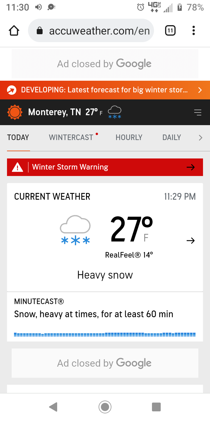
Temperature has dropped to 24.7 and it's sleeting mixed with snow...I don't see anything on radar, does anyone else
- 99 replies
-
- 1
-

-
- ice
- freezing rain
- (and 1 more)
-
Have had steady freezing drizzle and a few flakes.....at 29 currently but not expecting much of a rise today. School cancelled for Cumberland county not sure of other counties
- 99 replies
-
- 1
-
-
- ice
- freezing rain
- (and 1 more)
-
Temperature is down to 33 already, very quickly dropping from my previous reading, steady light to moderate rain
- 99 replies
-
- 2
-
-
- ice
- freezing rain
- (and 1 more)
-
Yeah we never got to our forecast high either, they had us at 55 and the highest I saw was between 50 and 51
-
Heavy rain starting here after a several hour lull, temperature is 49, ugh ....way too warm. Hoping the cold air gets here more quickly than forecast. Any hope for that out there?