

Wintersnow888
-
Posts
172 -
Joined
-
Last visited
Content Type
Profiles
Blogs
Forums
American Weather
Media Demo
Store
Gallery
Everything posted by Wintersnow888
-
Yep, I remember that storm , it was great !!! Had to drive to Chattanooga right afterwards, and I remember being one of the few cars on the interstate, and didn't see one snowplow the whole way.......I'm hoping that everyone scores this time , especially the ones in the forum that got little or nothing last time
-
Agreed. You and I are much higher elevation-wise than downtown Crossville.,. Have gotten 8 inches before and driven to town where they had maybe an inch and a half
-
32 degreesSleeting here
-
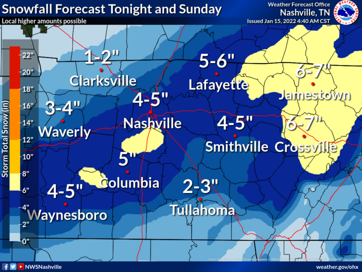
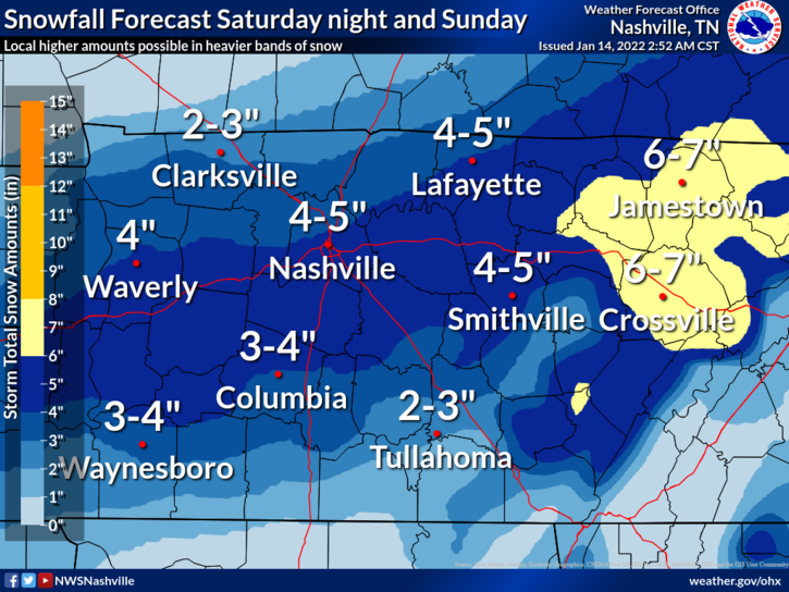
Looks like the area of 6-7 has been expanded since last night from Nashville NWS
-
Saturday Night Rain and snow, becoming all snow after 1am. Low around 32. East wind 10 to 15 mph, with gusts as high as 20 mph. Chance of precipitation is 80%. New snow accumulation of 1 to 3 inches possible. Sunday Snow. High near 36. Northeast wind 10 to 15 mph becoming northwest in the afternoon. Winds could gust as high as 20 mph. Chance of precipitation is 90%. From NWS.... Just thought it was notable that the Sunday part doesn't give a number....it just says Snow ....
-
UPDATE... FOR 06Z AVIATION DISCUSSION. && .DISCUSSION... Cool and cloudy at update time. Pretty quiet out there. We`ll take it because the next couple of days are going to be hectic. I`m not going to go into a bunch of in-depth analysis here, mainly because the 00Z model suite hasn`t come in yet. I`ll leave that to the overnight crew. What I will say is that several places in Middle TN look like they`re going to get more snow than they bargained for Saturday night and Sunday. Yes, models are all over the place as far as positioning where the heaviest snow is going to fall, but if there`s anything they agree on, someone (or a large swath of someones) is gonna get hammered. Of note, the 00Z HRRR has finally started to show heavy snow accumulation. I mention this, because arguably, the HRRR did the best with the last two snow events across the mid-state. That said, I have also seen evidence of forecast soundings showing strong Omega signs in the dendritic growth layer across a good swath of I-40 and south. How`s that for scientific? Basically, it means heavy snow for a period of time. All of this is leading to potentially 4-8 inches of snow across a good portion of the area and I wouldn`t be surprised to see a couple of spots see more and even a few spots (probably our far northwest counties) see something closer to an inch. I think the bottom line is: be prepared. Many places are going to get a bunch of snow and everyone knows how even an inch of snow can cripple TN when it comes to travel and traffic. Be prepared for major travel impacts by late Sunday morning, lasting through the night and probably even worse Monday morning in the aftermath as temperatures in the morning should bottom out in the 20s, freezing over anything liquid on the roads. Afternoon temperatures Monday will try to inch towards 40 but I`m seeing a lot of clouds Monday, so the sun may not be out to help melt anything on area roadways. Hopefully by Tuesday, we can start getting things back towards normal. && .AV
-
Looks like the valley gets something on the latest from Nashville NWS can't tell exactly how much.....
-
Haha no kidding
-
Weather channel forecast for me has 3-5 inches of snow Saturday night and 5-8 inches on Sunday...wish I could believe it
-
Just wondering why the Nws seems to have an above normal bias in their 6 -10 day outlook? Or is it just me? I remember they did the same last winter right before we had a long stretch of below normal days. I know the TV Mets usually ( not always- had a fair minded one in St Louis who didn't) say "Unfortunately, it's going to be cold and snowy the next few days," but they are talking to an audience of people who mostly prefer warm weather.....but I expect the NWS to be unbiased. Am I wrong? Sorry I should have put this in the Banter thread
-
That happens alot for us up here on the plateau, I've had it snow for several hours with nothing on radar. Nothing heavy just a steady light snow. I think your explanation fits , or maybe the orographic flow wrings out the moisture from the air perhaps, since I've noticed it on the back side of storms mostly
-
So right now I've got about 5 1/2 - 6 inches. This time I put out a board because I couldn't get an good reading last storm. But it really hasn't stopped coming down,just slowed and is now very small flakes , almost graupel. Nothing on radar over me right now in NW Cumberland co
-
I had same issues but one of the forum members told me that if you take a screenshot of your photo then try to upload it it reduces the file size considerably. I've gotten good results with it, good luck
-
Same thing happened here with the temperature right before it started heavier snow - hope that happens there !
-
Yep , really has picked up, road mostly covered.... amazing how the temperature dropped when it started snowing, I know the science but it's cool to see it in action
-
No more virga , snowing now and sticking. Hope everyone scores on this one......!!
-
Temp dropping again also from it's high of 27
-
Ditto
-
Radar shows precip over me but nothing reaching the ground yet, temperature has risen a bit to 27
-
DISCUSSION... Latest surface obs show Arctic air continues to filter into Middle Tennessee from the north this morning, with current temperatures in the upper 20s to low 30s and dewpoints way down in the 10s and 20s. Radar imagery already shows widespread precipitation developing across eastern AR, west TN, and northern MS, and this activity will continue to spread northeast into the forecast area early this morning. Increasing lift ahead of an approaching powerful 110+kt jet streak, along with a surface low tracking from central LA across MS/AL/GA and into the Carolinas through the day, will promote increasing intensity of the incoming precipitation as it moves across Middle Tennessee this morning and early afternoon. All precip is anticipated to quickly exit the area by late afternoon and early evening. Forecast soundings from all the latest available models and CAMs continue to show that profiles for areas roughly along and north of the I-40 corridor will remain well below freezing throughout the troposphere, with all snow anticipated for this event. Dry air in the low levels initially will require saturation for precipitation to reach the surface this morning, but guidance indicates this will happen fairly quickly due to the intensity of the large scale lift. Once saturation occurs, snow could fall fairly heavily at times and allow for rapid accumulation due to surface temperatures being near or below freezing. Several CAMs are notably going gangbusters with snow amounts, but these totals do not match the QPF shown by most models, and may not account for the initially dry low levels. Went with a more reasonable 3 to 5 inches for much of the area, although 6 to 7 inch amounts are possible in some locations. These totals are close to the 50th percentile of all model guidance, and also in line with WPCs latest forecasts. Notably, these snow amounts are above the 00Z ECMWF but below the latest GFS
-
When did they change it to a WSW ? Just curious. Temperature is down to 24 here between Crossville and Monterey ( closer to Monterey actually) , so I guess we won't be getting much rain, if any !
-
So when I read the text on the WWA for my area , upper cumberland , it said 2- 4 with locally higher amounts of 5- 6 inches. And it said they may change to a WSW ..... I tried to copy it over here but failed, must be doing something wrong. Maybe someone with better skills could do it haha. Anyway, hope we don't get any rain with this one
-
Yes It did the sleet snow mix for about 25 minutes and then flipped to snow ... Good luck!
-
Once the sleet started here in Cumberland it didn't last long, snow filled in fast Hope you all get the same in the valley!
-
I tried to copy it here but failed ☹️

