Wintersnow888
-
Posts
172 -
Joined
-
Last visited
Content Type
Profiles
Blogs
Forums
American Weather
Media Demo
Store
Gallery
Everything posted by Wintersnow888
-
Fall/Winter Banter - Football, Basketball, Snowball?
Wintersnow888 replied to John1122's topic in Tennessee Valley
This is the forecast for where I used to live in St Louis county before I moved to Tennessee .... would love to take a road trip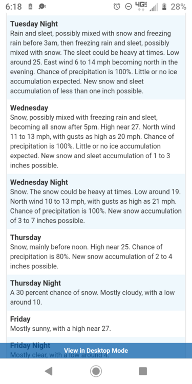
-
January 28th-29th Clippers/NW Flow Obs/Last Minute Forecasts.
Wintersnow888 replied to John1122's topic in Tennessee Valley
Mine did the same thing last night. The lowest I got was 15 at 11:30 . I have friends across 70n who measured 13.7, which is close to your reading . My grandfather used to tell me that this was one of the coldest spots in the area, so I guess he was right. He was the county agent for Cumberland and was interested in weather also , I got the bug from him for sure -
January 28th-29th Clippers/NW Flow Obs/Last Minute Forecasts.
Wintersnow888 replied to John1122's topic in Tennessee Valley
Made it but had to detour once around a closed road due to multiple car accident....... Basically unable to see road because covered with two or three inches of packed snow. Still coming down at home and temperature at 21 -
January 28th-29th Clippers/NW Flow Obs/Last Minute Forecasts.
Wintersnow888 replied to John1122's topic in Tennessee Valley
That's where I live....... trying to get home haha -
January 28th-29th Clippers/NW Flow Obs/Last Minute Forecasts.
Wintersnow888 replied to John1122's topic in Tennessee Valley
Already over the forecast amount by a factor of 3 haha -
January 28th-29th Clippers/NW Flow Obs/Last Minute Forecasts.
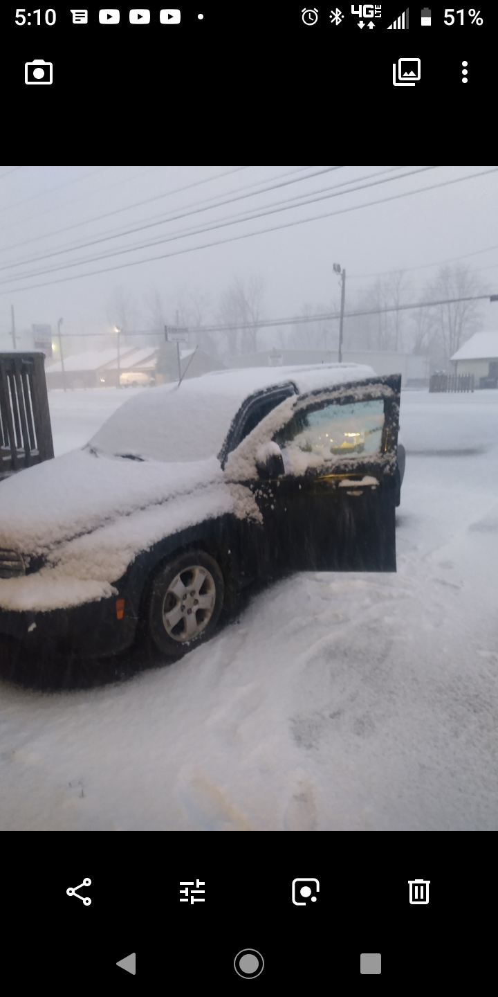
Wintersnow888 replied to John1122's topic in Tennessee Valley
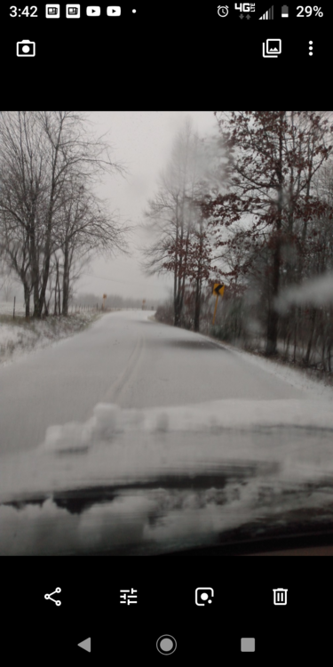
Here's my car
-
January 28th-29th Clippers/NW Flow Obs/Last Minute Forecasts.
Wintersnow888 replied to John1122's topic in Tennessee Valley
-
January 28th-29th Clippers/NW Flow Obs/Last Minute Forecasts.
Wintersnow888 replied to John1122's topic in Tennessee Valley
Scratch that, I already have almost 2inches, must be under a heavy rate band , visibility is down to about 1/2 mile -
January 28th-29th Clippers/NW Flow Obs/Last Minute Forecasts.
Wintersnow888 replied to John1122's topic in Tennessee Valley
Just started pouring snow big flakes, just in the last half hour or 45 minutes, ground and road already covered with an inch quickly -
January 28th-29th Clippers/NW Flow Obs/Last Minute Forecasts.
Wintersnow888 replied to John1122's topic in Tennessee Valley
Cumberland county just let kids out of school at 1:00 for incoming snow they said....At the moment just flurries , as it has been doing all morning -
Well Cumberland county is letting kids out of school at 1:00.....just heard Because of incoming snow storm my message said
-
I drove down to town and it's amazing how much more we got than they did in Crossville proper....that extra elevation and being far enough NW really helps us out here. Wondering if being closer to the edge of the plateau helps also?
-
Are you getting any accumulation yet ? Hope so
-
Hope it does last until then ....... or longer!!
- 167 replies
-
- 2
-

-
- frost
- cold front
- (and 4 more)
-
It's 31 here an sleet mixed with snow , pretty heavy and sticking in the places that don't have puddles!!
- 167 replies
-
- 2
-
-
- frost
- cold front
- (and 4 more)
-
Yep I can confirm that report, looks like a couple of inches have come down already, flakes aren't as big as yesterday though
-
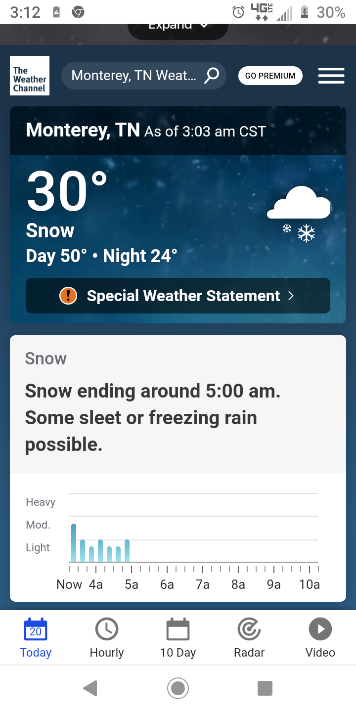
DISCUSSION... `Twas the night before MLK Day and all through Middle TN Not a creature was stirring Except for the snow that`s still falling on the Cumberland Plateau. Admittedly, it has lightened up a bit, but I think a good portion of the Upper Cumberland is probably going to see another 1-3 inches before the snow machines shut down for the night. Even then, up to another inch will be possible tomorrow morning as quick-moving clipper swings into the region around sunrise tomorrow. In fact, even though the west half the mid-state has cleared out, this clipper will bring more clouds after midnight. Here`s the downside: the cloudy skies tomorrow are going to hamper the snow melt and road improvement. So, with temperatures expected to fall into the mid-20s tonight and a lack of sunshine for most tomorrow, look for travel to be poor in many areas until late Tuesday morning. I`m going to throw an SPS out for patchy black ice for tomorrow morning`s commute, as well. Today`s snowfall winner looks to be Hohenwald with 9 inches and a report in Fentress near Clarkrange a close second with 8.75 inches. We`re still putting reports together and you can expect a map at some point tomorrow morning. &&
-
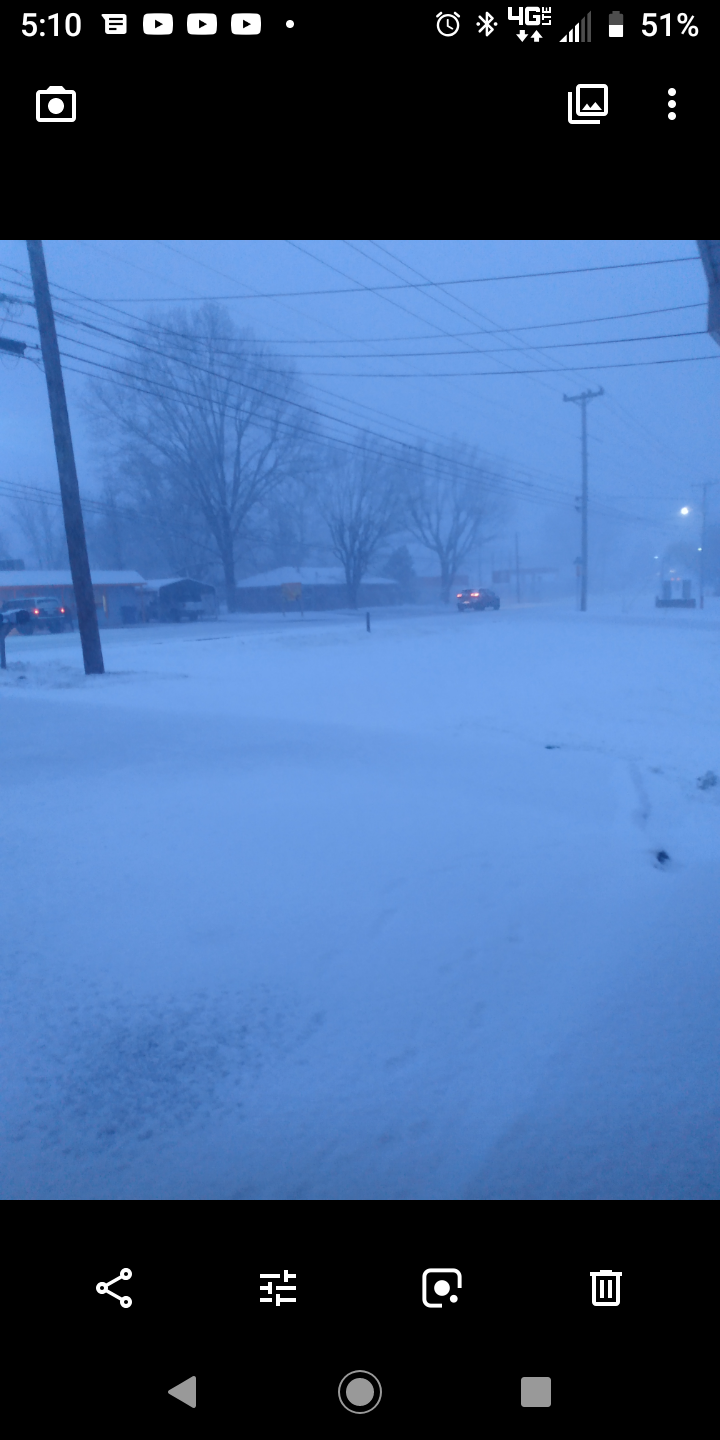
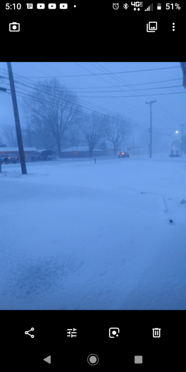
Here's my road
-
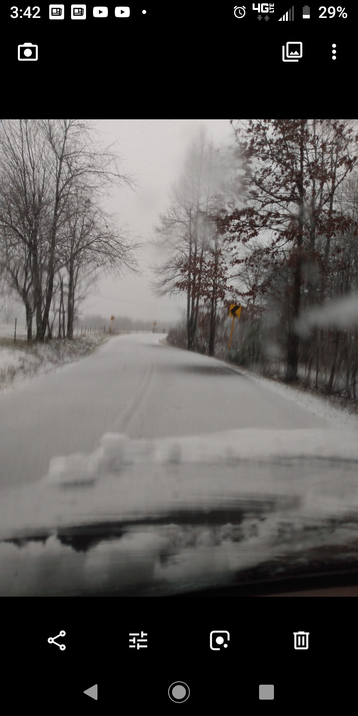
Almost all snow now after 2 8nches of wet sleet. Rates picking up
-
The 500 mb trough passage is expected to occur across southern portions of mid state region as morning hours progress and then during afternoon hours across Cumberland Plateau. This due to current surface and upper level lows progression northeastward out of southern MS River Valley Region but remain south of mid state region until they approach southern portions of Cumberland Plateau Region as afternoon hours progress. There is also no guarantee that enhanced snow bands might develop further north than expected either. Careful monitoring of temperature trends along with noting development of mircoscale features such as localized areas for enhanced up right convection development will need to be monitored through the evening hours tonight. Area road conditions are likely to deterioate as day progresses, even across most traveled mid state roadways. Thus only plan to travel if absolutely necessary, especially across Cumberland Plateau Region. It is not totally out of the question that some of the higher elevations across Upper Cumberland Region locally could get a foot of snowfall accumulation, making travel nearly impossible. Also play a role across mainly eastern portions of mid state region will be development of a strong low level atmospheric pressure gradient which could result in wind gust 30 to around 35 mph at times especially across Cumberland Plateau Region.
-
Switching back and forth from sleet to snow but the temperature continues to fall - dropping from 30 to 29 right now maybe because wind has really picked up the last four
-
Dropped to 30 degrees now ,have some sleet mixing in but road and everything is covered
-
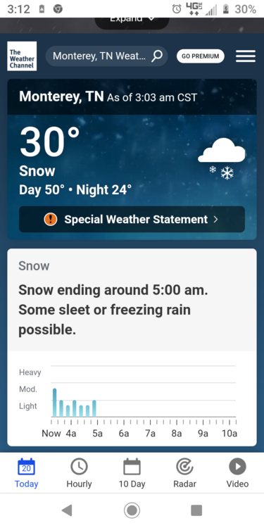
Radar over me looks like snow but still only rain , temp has dropped to 31 however
-
32 degrees and very cold rain, but nothing frozen yet
-
National Weather Service Nashville TN 542 PM CST Sat Jan 15 2022 .UPDATE... FOR 00Z AVIATION DISCUSSION. && .DISCUSSION... To put it mildly, a very complex winter weather system is moving our way. Upper level low is currently located over the Red River just west of the Arklatex. This feature will continue to deepen and intensify through Monday as it tracks across central Al and central MS before it takes a more northeastward turn. The associated surface low is located well to the east of the upper level feature but this displacement should decrease with time. Orientation of the surface low does reveal some n-s inverted troughing which does support warmer air in the lower levels. This trend continues through a big portion of tonight across our area. This leads me to believe that the the snowfall we are going to get across the mid state will hinge largely on the approach and passage of the 500 mb trough. At that point, the airmass will sufficiently cool down to support all snow. As we look toward the west we can already see this happening across Ar. Its in the 40s with rain over eastern AR and in the upper 20s to lower 30s across the west where the impacts from the approaching upper low are now felt. With the above said, our upcoming snow amounts will trend down slightly except across the Plateau. With the added elevation that the plateau brings, the warm layer in the first few thousand feet will much more shallow. Furthermore, the upper low and associated trough will be tilting more negatively as the deformation zone reaches that area. It is for this reason, the Plateau snow amount forecast will be on the impressive side with 5-10" expected. Furthermore, CSI parameters are in play to where a brief period of thunder snow cannot be ruled out. This would of course enhance snow fall amounts for that area even more. With decision time at hand, the trickiest part of this forecast is forecasting the amounts west of the Plateau. Hrrr and the Euro continue to show potentially higher snow band totals. The changeover to snow occurs quickly with heavy snowfall rates of 2 inches per hour. GFS...NAM and NBM solutions are much less aggressive with totals. So. have decided to go with a winter storm warning for all of the mid state except the far northwest which is where an advisory will be issued. Expected snow totals are as follows...5 to 10 inches along the Cumberland plateau...2 to 5 inches for the remainder of the mid state excluding the far northwest...1 to 3 inches in our far northwest. The advisory will begin at 6PM this evening with snow mixing in with the rain shortly thereafter. For the warning area, the warning will begin at midnight with the west to east transition of rain to a rain and snow mix overnight. Note that the Plateau will likely begin to changeover sooner given the reasons mentioned prior. The passage of the 500 MB upper trough axis will occur between 12Z and 18Z. It is at this time when the coldest air will move in and the precip will be mostly snow. Hourly rates could be rather impressive especially along the Plateau where the axis will begin to negatively tilt. The snow will taper off Sunday evening and along the Plateau at that time. Moving on, we do see another weak little system for Monday that could bring some additional snow flurry activity to eastern areas. But no additional accumulation is expected. In the extended forecast...a mid week arctic cold front is expected to move through. Surface energy will develop along the boundary and bring some shower activity to the area. Could see some snowfall on the back edge but nothing to be too concerned about at this point. Looking cold behind the boundary. A clipper system could bring some light snow to our area on Friday. Amounts look light. For your extended temps, 40s for Tues and Wed then c older late in the week. Its looking like 15 to 20 for lows and highs in the 30s Sorry it's so long but it was interesting