

Newman
-
Posts
2,500 -
Joined
-
Last visited
Content Type
Profiles
Blogs
Forums
American Weather
Media Demo
Store
Gallery
Everything posted by Newman
-
^That time for the gif I posted, yes you could argue it's already after the initial thump which it is. But we have that 2nd vort swinging through now on guidance and it would sure be nice for the mid-levels to still be cold enough when that happens to snow an additional inch or two on that passage. That second vort attempts to wrap up and bring in some cold air on the backside, but there's so much energy crashing into the west coast reducing any chance for amplification. It's a New England special, and an interior one at that
-
-
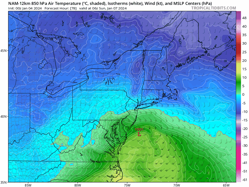
12z NAM is a touch warmer unfortunately compared to 6z. Still a nice 6 hour thump for the LHV
-
I knew this thing would trend north, but honestly not THIS much. Definitely have to temper expectations. I still think it'll move back south a bit, but really only benefitting places like the LHV. I guess we'll see, congrats New England
-
Euro just went way NW
-
Ukmet definitely cut back for max totals west of 95, QPF a bit less. General 6-10" swath. DC would be marginal
-
Over the years living in PA, I slowly became a HECS chaser to be honest, especially after Jan 2016 and Jan/Feb 2021. Storms like the one coming up wouldn't typically excite me. But it's been a long time coming and my pops loves snow and wants this one badly. I'm excited for y'all, I'm flying back literally Saturday morning so I'll be missing it
-
If you've been doing this long enough, you know the Canadian always always always has an overamped bias and puts down more QPF than feasible (in most cases). The 12z CMC is a shallacking for those NW of 95, but the 12+ totals seem suspect. The storm is literally in and out in 10-12 hours. Yes, I've seen quick moving thump and dump storms consistently average 1 inch hour rates for the duration of the storm. Can't remember which events, but I've seen it during my times in PA. If the Canadian were to come to fruition, I'd imagine there would be some 10" lollis NW of 95. But this isn't a slow moving transfer storm. Again, if you're NW of 95 I'd be expecting a solid accumulating wet snowfall. Those furthest NW and into central PA will have the jack
-
The entire evolution of this storm has obviously changed since just a few days ago, everyone can see that. It'll be a quick thump of snow for 6-8 hours probably Saturday night. I think that bodes for max amounts around 6-8", unless we see a change as we get closer. Still sticking with my first call that the lollipop max is northern Berks up through the Poconos for our CWA. Not a trivial forecast, climo basically
-
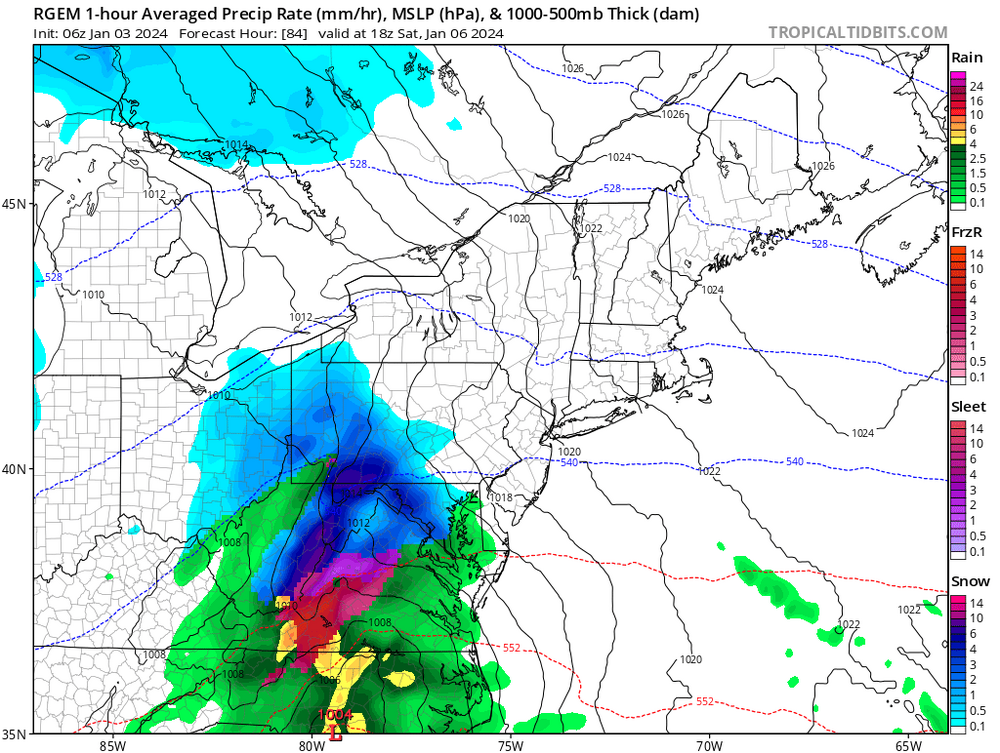
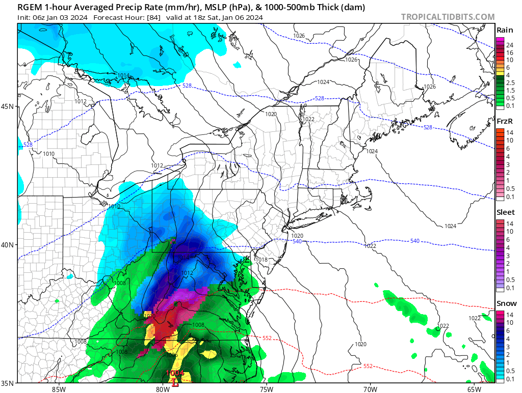
6z RGEM at the end of its runtime, sticking close to its global counterpart. The NAM... just don't look at it unless you want disappointment

-
These are the amounts apart of the ULL pass through behind the main "system". Many get 2-6", then we snow through the next day adding on another 2-4
.thumb.png.05ed89264ff115b607ebd7f267643b38.png)
-
Canadian with probably the best hit yet those along and NW of 95
-
The 12z GEFS just shifted significantly further north with a much lower snowfall mean for the entire area
-

Two Mdt to high impact events NYC subforum; wknd Jan 6-7 Incl OBS, and mid week Jan 9-10 (incl OBS). Total water equiv by 00z/11 general 2", possibly 6" includes snow-ice mainly interior. RVR flood potential increases Jan 10 and beyond. Damaging wind.
Newman replied to wdrag's topic in New York City Metro
Big time changes on the GEFS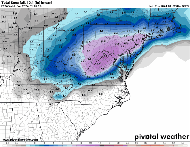
- 3,610 replies
-
- 4
-

-
- snow
- heavy rain
- (and 5 more)
-
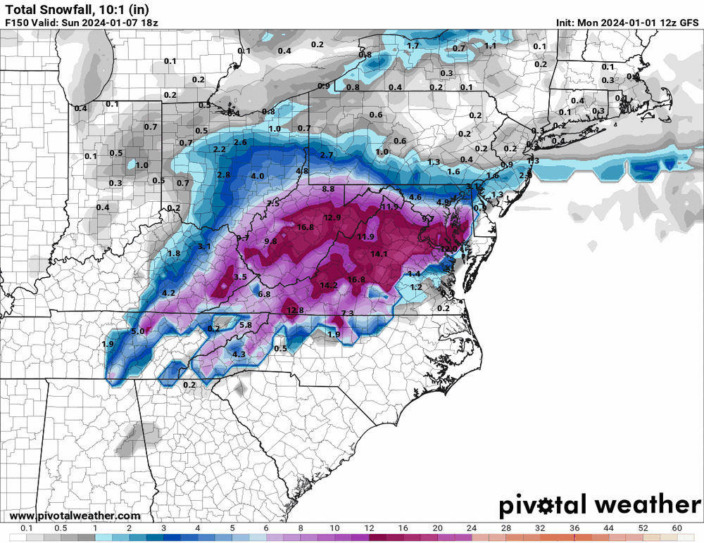
The GFS coming in with it's most north and warm run yet. And as I suspected, it's weaker as well. The 12z CMC coming in south from it's previous runs though, almost lining up with the GFS
-
I'm heading back west on Saturday morning, just in time to miss the first big east coast snow in 2 years... Helped my dad pull the snowblower out and gas it up yesterday. Berks and the LHV usually does well in these types of storms, in fact even though we're still days away I wouldn't be surprised if they "jackpot" with heavier totals. All speculation as of now. One thing I've noticed just glancing at the models is there seems to be a cap on totals with this. A relatively quickly moving system so despite being a STJ brewed storm, there won't be much time to precipitate absurd amounts. 12-15" max type of storm, which is still great especially after the past few winters. GFS has obviously been trending much further north with Confluence in SE Canada retreating further north. Euro is better, CMC worse. Seems like a classic EC storm progression leading up! If I had to take a crack at where the heaviest band sets up, I'd say Northern Berks up through Lehigh, Schuylkill, Carbon, Monroe... That general area. I do believe amplification and a warmer solution is much more probable compared to getting a whiff south
-
E PA/NJ/DE Winter 2023-2024 OBS/Discussion
Newman replied to The Iceman's topic in Philadelphia Region
Yep heading back to Wyoming after the New Year! It's been a good time back in PA, but I'm ready to be back in WY with a lot less people and more snow lol -
E PA/NJ/DE Winter 2023-2024 OBS/Discussion
Newman replied to The Iceman's topic in Philadelphia Region
The roads are absolutely horrible around Reading and Allentown, lots of ponding and flooding going on -
Mountain West Discussion- cool season '23-24
Newman replied to mayjawintastawm's topic in Central/Western States
KLAR got down to -12° it looks like, quite the cold pool that settled into the valley overnight with added benefit from some of the snow around -
Mountain West Discussion- cool season '23-24
Newman replied to mayjawintastawm's topic in Central/Western States
Laramie regional AP broke daily record highs for 4 straight days this week 12/18-12/21 with an outside shot at 5 straight tomorrow -
One of my buddies in Leesburg sent me a pic at 4am with what looked like only a dusting. I'm not familiar with the VA/MD topography too much, but that's pretty wild that only a short ways to his east many saw 1.5-2". Even west in Round Hill, VA has a report of 1.5. Anyone else in Leesburg can confirm?
-
E PA/NJ/DE Winter 2023-2024 OBS/Discussion
Newman replied to The Iceman's topic in Philadelphia Region
Dad sent me a photo of the snow in Fleetwood, about 1" on the measuring board, 1.5" on cars/deck -
E PA/NJ/DE Winter 2023-2024 OBS/Discussion
Newman replied to The Iceman's topic in Philadelphia Region
NAM is actually pretty impressive for the storm Monday regarding the *possible* snow on the backside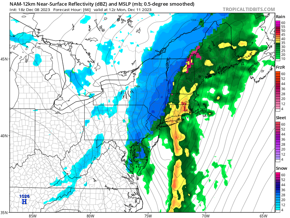
-
Mountain West Discussion- cool season '23-24
Newman replied to mayjawintastawm's topic in Central/Western States
Currently got some snow falling and stickage in Laramie, NWS forecasting 1-2" here through the evening -
Mountain West Discussion- cool season '23-24
Newman replied to mayjawintastawm's topic in Central/Western States
I'm flying back to Denver tomorrow morning and will be in at 8am, I'm hoping 287 back to Laramie isn't closed. It looks like I-80 between Cheyenne and Laramie is currently closed


.png.935c519d7076feb1fa60aa32573002c9.png)


