Newman
-
Posts
2,485 -
Joined
-
Last visited
Content Type
Profiles
Blogs
Forums
American Weather
Media Demo
Store
Gallery
Everything posted by Newman
-

Saturday night/Sunday 12/13-12/14 Jawn
Newman replied to Ralph Wiggum's topic in Philadelphia Region
Temp is down to 32° in Fleetwood with moderate snow according to my folk, looking forward to the pics from everyone. It will be my first ever winter not seeing snow now that I live and work in Florida so I will live vicariously through you all, enjoy this one! -
Saturday night/Sunday 12/13-12/14 Jawn
Newman replied to Ralph Wiggum's topic in Philadelphia Region
I'm surprised Mount Holly didn't mention "localized 6 inches" for the WSW. I also thought they might follow what State College did with Lancaster and York counties and put Berks, Lehigh, Northampton under 2-5 inches. Would love to read their latest AFD to see if they're just playing it safe or if they don't trust some of the latest short term guidance from the HREF, HRRR, and RRFS. It's also kinda splitting hairs I know -
Saturday night/Sunday 12/13-12/14 Jawn
Newman replied to Ralph Wiggum's topic in Philadelphia Region
HRRR has a band with 1"+ rates set up over Lancaster -> Lehigh from about midnight through 4am. Whoever ends up under that 850-700mb fronto band for an extended period of time will easily grab 4-6" -
Saturday night/Sunday 12/13-12/14 Jawn
Newman replied to Ralph Wiggum's topic in Philadelphia Region
Close to go time I know, but 6z EPS bumped up QPF as well. Upper-levels ticking more favorably, hopefully the ticks continue right up to storm onset. Philly EPS mean is 4" and probability of snowfall exceeding 4" is now 53%. -
Saturday night/Sunday 12/13-12/14 Jawn
Newman replied to Ralph Wiggum's topic in Philadelphia Region
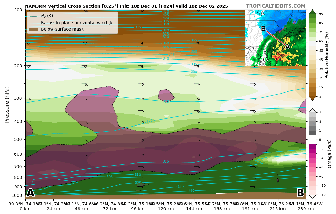
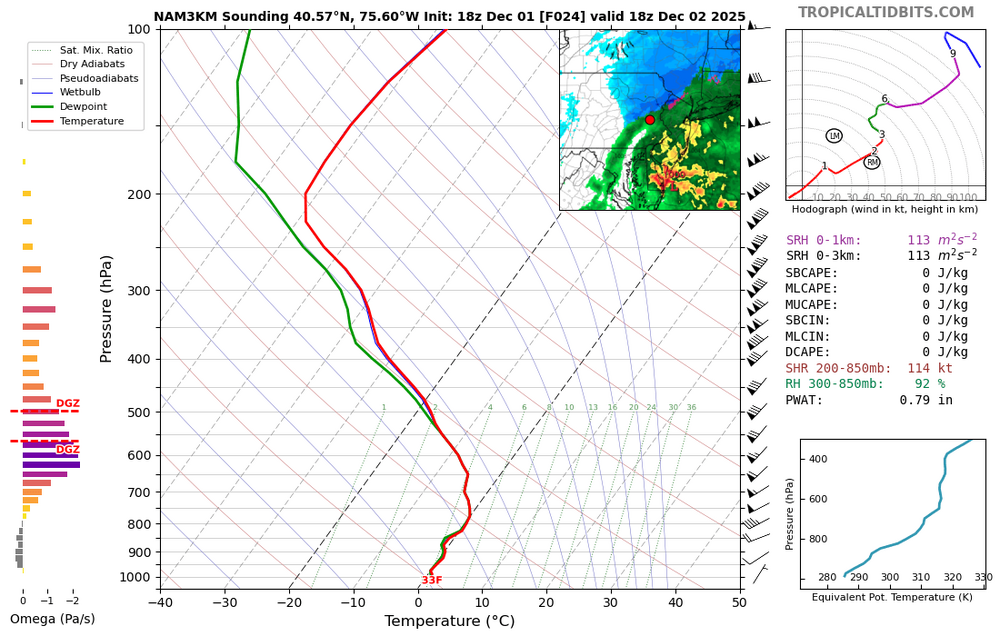
1am sounding for Allentown off the 3k, wow! Plenty of ascent right in the DGZ. The 10pm - 3am timeframe will probably be when the LHV gets the best rates before everything shunts southeast. Snow might be done by sunrise tomorrow morning.thumb.png.15039e680f80f47d90cace2746488a16.png)
-
Saturday night/Sunday 12/13-12/14 Jawn
Newman replied to Ralph Wiggum's topic in Philadelphia Region
6z Euro is quite a bit more wet for the Lehigh Valley. Solid 2-4", many of the mesos are also bringing WWA amounts north. Should be a solid event for the area. -
Saturday night/Sunday 12/13-12/14 Jawn
Newman replied to Ralph Wiggum's topic in Philadelphia Region
12Z Euro shifted a bit back SE after the northwest bump at 6Z. It digs the TPV just a bit further south over the Great Lakes which keeps the heights a smidge more suppressed. But largely it's been super steady. 1-2" across the Lehigh Valley and 2-4" I-95 corridor sounds like a good bet. -
Saturday night/Sunday 12/13-12/14 Jawn
Newman replied to Ralph Wiggum's topic in Philadelphia Region
A couple things I'm interested in: 1. As we near this event, how do the mesos trend with the upper level jet and any small ticks in TPV placement to allow greater height rises (or worsening). 2. QPF trends on guidance, especially along the northwest edge of the precip shield. Latest RGEM stays wet for the Lehigh Valley (0.2-0.3" of precip), NAM much drier. 3. Post-storm, I'm curious what the SLRs end up being. The NAMs are the most aggressive (no surprise) in some solid omega within the DGZ and also 850mb fronto, but mostly along and south of I-95 once the storm starts to get going a bit. I'm curious to compare 10:1 and Kuchera model maps to reality. -
E PA/NJ/DE Winter 2025-26 Obs/Discussion
Newman replied to LVblizzard's topic in Philadelphia Region
NAM in line with the Euro, obviously more amped because it's the NAM. But cut some of that QPF and it's a general 2-4" along the I-95 corridor. It's a shame this isn't coming 6-12 hours later for the Eagles game -
E PA/NJ/DE Winter 2025-26 Obs/Discussion
Newman replied to LVblizzard's topic in Philadelphia Region
Euro has been largely consistent in showing a general 2-4" for much of the Philly metro the past few runs with upwards of 5" in localized spots. Berks, Lehigh, Northampton probably 1-3" but this is one of those setups where you can get a strong fronto band on the NW side of the precip shield as the upper level jet shifts towards the area under the favorable right entrance region. I think the precip shield would actually expand a bit further northwest than what the Euro shows with isentropic glide along the frontal boundary as the TPV drops in from the north. However, that same TPV is pushing everything along and out to sea so it's a fine balance between the flow buckling and getting that precip shield to expand vs everything shunted east. Will have to watch the trends with the models, have to get a bit greater height rises ahead of this one -
Glad you posted this as I came to check what others were getting SLR in the DMV region. Friend (who's also a met) from Leesburg sent me this a bit ago: "So I measured a measly 0.04" of melted precipitation at 845am, and another 0.01 at 1pm. So I grand total of 1.7" from 0.05". I felt like it doesn't make sense so I measured the melted precipitation from a core sample off the deck that was around 1.25 to 1.5" and it was just above .03", so I don't know ha" Seems like some real fluff up there today
-
Friend just measured 1.7" on his snowboard in Leesburg. Final band might push it to 2?
-
E PA/NJ/DE Winter 2025-26 Obs/Discussion
Newman replied to LVblizzard's topic in Philadelphia Region
Extended pattern looks great if you're into cold and dry northwesterly flow with maybe an occasional clipper system potent enough to deliver C-2" of snow -
Does anyone know of anywhere that has MJO RMM plots before 1975? The Australia BOM archived site only goes back to 1975.
-
12/3 Snow/Sleet/Mix Bag of Everything Discussion/OBS
Newman replied to Mikeymac5306's topic in Philadelphia Region
Mix line seems to be washing out a bit on radar, could flip back to mostly snow for a time. Still 29° in Fleetwood -
12/3 Snow/Sleet/Mix Bag of Everything Discussion/OBS
Newman replied to Mikeymac5306's topic in Philadelphia Region
Sleet line already up to southern Berks, can see it quickly racing northward on CC -
12/3 Snow/Sleet/Mix Bag of Everything Discussion/OBS
Newman replied to Mikeymac5306's topic in Philadelphia Region
23/19 in Fleetwood right now -
12/3 Snow/Sleet/Mix Bag of Everything Discussion/OBS
Newman replied to Mikeymac5306's topic in Philadelphia Region
3k actually never gets KABE above freezing at 850s (though it's close), but does sneak to 33 at 925 down to the surface. At 1-2pm tomorrow, the 3k shows rain BUT some deep lift just below the DGZ and even stretching into the DGZ. The DGZ is pretty high up in the atmosphere, but as you can see in the skew-T the sounding is marginally above freezing. If you can get some deep lift and rates to increase within a backside band as the storm departs, you could potentially finish with some heavy snow and fat dendrites if the column cools isothermally back to freezing. Of course, all of this could be for nothing and if 1.) The mesos are correctly handling temperatures and 2.) The rates aren't heavy enough to cool the column then we'll definitely see the lower end of snow totals materialize. Just wanted to point out a way that you could potentially see higher end (3-4" totals) materialize along the I-78 corridor which is currently the 90 percentile from the NWS.
-
12/3 Snow/Sleet/Mix Bag of Everything Discussion/OBS
Newman replied to Mikeymac5306's topic in Philadelphia Region
GFS at 18z remains colder than any of the mesos for the I-78 corridor and even ends as snow around 2pm tomorrow. It's probably not picking up on the warm punch, but given the soundings are all basically 33-degrees and isothermal, maybe the models are underestimating the cold tonight? Will just have to see what happens, NWS forecast looks great to me based on current guidance. -
12/3 Snow/Sleet/Mix Bag of Everything Discussion/OBS
Newman replied to Mikeymac5306's topic in Philadelphia Region
Not the trend you want to see up to storm onset. 925s and 850s are just too warm, which makes sense given the setup. Hopefully this trend halts and we see things shift SE tonight. But at that point, it's time to look at obs and radar watch. Shaping up to be a typical early season interior storm with maybe a surprise 1-2" thump on the southern boundary along I-78
-
12/3 Snow/Sleet/Mix Bag of Everything Discussion/OBS
Newman replied to Mikeymac5306's topic in Philadelphia Region
Yeah 12z models coming in warmer for those who were on the line NW of 95 up to I-78. I still think Berks, Lehigh, Northampton can squeeze out 1-3 inches on the initial thump IF it starts as snow. However, if there's a pesky warm nose (i.e. that some of the warmer guidance shows) things could start as sleet which would cut down entirely on snow totals. It's not really a sleet type of storm, though I'm talking about the initial thump before the true warm surge happens as the low tracks to the S and SE of the area off the coast. -
E PA/NJ/DE Winter 2025-26 Obs/Discussion
Newman replied to LVblizzard's topic in Philadelphia Region
Really tricky forecast for Tuesday across Berks, Lehigh, Northampton counties per usual. Expecting the R/S line to make it to the 78 corridor, but never know. How much snow falls in these areas will depend on how quickly/heavy the initial WAA snows come in and how quickly (or not) the warm nose aloft lifts north. Southern parts of these counties won't do as well as the northern parts. I'd expect sleet to mix in more than expected, but we'll have to see what the CAMs show the next few cycles. Regardless, small shifts will make a big difference in these counties and it'll probably be a nowcast to see where the R/S line is on CC radar. 2-5" is a good call, 2 being the low end and 5 the 75th percentile or so. Reasonable worst case scenario is probably 6 or 7 inches -
As has been discussed ad nauseam here, I don't believe there's anything to worry about regarding a colder and *potentially snowier* pattern setting up mid-December and beyond for the northeast. The SE ridge will be suppressed enough to allow the baroclinic boundary to slowly inch south and eastward towards the coast, the CPC map you shared is highlighting that (just compare weeks 3-4 to weeks 2-3). It won't happen in an instant, but the cold will try to bleed south into the northern Mid-Atlantic towards the second or third week of December which should offer chances of snow. The nuances in the flow are impossible to figure out at this point, hence *potentially snowy*. Fail mode is obviously if the -PNA overpowers any SE ridge suppression.
-
Yep I was wrong. The sheath was positive though which doesn't mean anything until we get into the flux rope which we've seen can instantly flip negative (or stay positive)
-
CME arrival appears to be running a bit behind the initial forecast of a 15-18UTC hit. Seeing indications of a 21-00UTC (4-7pm EST) hit instead, but I guess we'll see. And of course, we need a southward (negative) Bz for the storm to be geoeffective!

.png.f07c2ebea5f340a7ca20012952e6e770.png)