

Scarlet Pimpernel
-
Posts
7,346 -
Joined
-
Last visited
Content Type
Profiles
Blogs
Forums
American Weather
Media Demo
Store
Gallery
Posts posted by Scarlet Pimpernel
-
-
1 hour ago, psuhoffman said:
I like the long range 12z GEFS even more. Better ridge axis out west. Lower heights in the Atlantic. It’s getting even closer to “THE” look
We talkin' 1996??


-
 2
2
-
-
On 12/25/2020 at 2:17 PM, Maestrobjwa said:
Sending Merry Christmas blessings to all of you! Be careful not to let any snow worries cloud this special day...bask in the hope and joy of Christmas (yes, believe it or not, it is there even in a year like this). God bless!

Seeing that my lower back went out on me (again!) right on Christmas Eve, at this point I could give f*ck-all about how many cutters we get in the next couple of weeks!
 That's not really aimed at you, just a convenient place to throw that in there! Sucks...I've had semi-chronic issues with the lower back for several years, a lot of that my fault by lifting things the wrong way without paying attention, that sort of thing (use your knees more when lifting, and tighten your core, dammit!! LOL!). Then all it takes is one little move when it's somewhat weakened by such activities, and...*wham!!** it essentially charley-horses on me and takes a couple or so days to "un-knot" itself. So yeah, I should be more cognizant of how I lift things, and I'm reminded that I should keep up with the exercises I should be doing to keep it in decent shape! But...that all said, that did not ruin the holiday for me!!
 ")
Oh, and I agree with you...even in a year such as this, there is some joy at this time of year all the same, and hope for the upcoming year! Part of the Holiday music listening included a CD we have called "Festival of Carols", a compilation of Christmas carols as conducted by Robert Shaw (thought you would appreciate that!)...perhaps my favorite!
-
 1
1
-
-
Happy Christmas, everyone!! May you all find peace and joy today, and better things to look toward heading into 2021!!
-
4
-
-
-
Streaming high clouds from this afternoon...

-
4
-
-
1 hour ago, H2O said:
BobChill does. Oh thats right. He isn’t here. What does that mean

We need @WxWatcher007 to come out with that Bat Signal picture that he uses for @Mrs.J...only in this case, put @Bob Chill's icon on there!!
-
1
-
-
Just now, nw baltimore wx said:
What a fantastic movie!
Agree, it was a great film on many levels, with fantastic acting! I have a copy of it and have seen it several times over the years.
-
1
-
-
7 minutes ago, leesburg 04 said:
wait....didn't everyone and their mother say this winter was going to suck moose balls? Some of us had a really nice event last week already and December is definitely colder than some thought and January looks to be colder to start....how deflated can you be if winter actually does suck moose balls? I mean it's all going according to plan right?
I don't know...the moose may like that!!
-
Apparently this is what the latest ECMWF looked like:

-
4
-
-
2 minutes ago, JakkelWx said:
Cutter.
2 minutes ago, psuhoffman said:Cutter
Looks like I need to watch "Breaking Away" again...
-
1
-
-
12 minutes ago, psuhoffman said:
I guess those were ok storms
So...essentially just like 1996 then!! That'll never get old. Or will it???
(***No dead equines were harmed by this comment!)
-
3
-
-
13 minutes ago, DCTeacherman said:
This is snow Buddhism. Learn to want you have.
Well, in keeping with @yoda, who started this thread..."Snow or snow not! There is no try!"
-
1
-
-
2 minutes ago, Ralph Wiggum said:
But 95-96!!

")
Hahaha! Well, "best pattern since '96" might surpass "transient" as the most over-used word/phrase for this winter!!
-
2
-
2
-
-
10 minutes ago, psuhoffman said:
Thanks...
I am going to straight up drop kick the first person who complains if we get a 6-10" snowstorm in the 95 corridor. It's a Nina. Expectations!!!
Haha! Give 'em the Ray Guy treatment!! That person who complains might be (ahem)JI(ahem)!!
(ETA: and to keep up with the alliteration, you can refer to those who complain as "Nattering nabobs of negativism!!")
-
1 minute ago, psuhoffman said:
I think we need to stop focusing on getting the PERFECT pattern and look at what works in a Nina. We likely are not getting a picture perfect pacific pattern. Nor do we need the ABSOLUTE perfect block to get a snowstorm. We do if we want a HECS. But we likely aren't getting a 20" HECS storm either...there has only been 1 of those (1996) EVER in a Nina going back to 1900! But we have had plenty of warning level snowfalls in a Nina. This is the composite of 6 of the best Nina snowstorms since 1950 between Dec 15 and Jan 30 at BWI. I left off really early and after Feb 1 storms because our snow climo wrt what works is slightly different very early and later in the season. So these are good "models" for what works this time of year in a nina. All of these were warning 5"+ events at BWI and some of them were very nice ~10" events in our area.
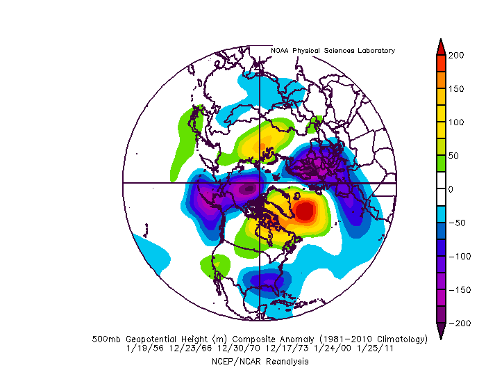
Here is what I take away from that look, and what has worked in past Nina's to get snow. Notice that trough in and around AK. No that is not ideal but its acting to suppress the pacific ridge associated with a Nina. In that regards...its actually helping more then its hurting assuming it stays centered WEST of AK. If it shifts east too much its a problem and we get flooded with pac puke. Centered west of AK and it damages the thermal profile of the CONUS yes but its not fatal. There can be just enough trough into the east to get domestic polar air into the northeast. It is what it is...you lose that trough there and the central PAC ridge goes APE and its all over...you get a trough in the NW and ridge out in the east. The -NAO is critical to this because it helps retrograde that trough out of western North America just enough to make this workable. Lose the -AO/NAO and the Nina PAC ridge can exert itself and that trough in AK shifts east into NW NAM and its last year all over! Notice also the NAO is centered east of ideal there. But what is critical to get that to work is to have SOME extension of the ridge west towards Hudson Bay. But...that said...there are some analogs in there where the NAO blocking is centered pretty far east (2000 is one recent example) and still managed to work out. There are also numerous other decent snowfalls...advisory in the city and warning NW that I didn't bother to include but that show a similar picture in terms of how to get snow in a Nina and what typically works.
Lovely alliteration there, intentional or not (picture perfect pacific pattern)!!
At any rate, good discussion of how we can get decent moderate events, if one is not so hung up on HECS chasing.
-
Just now, Maestrobjwa said:
Ha, well I don't know who was saying that about the 3rd week of January...because if you look at our history that around the time when the money period starts!
But yes, as WSW breakthrough would be nice!
When it became apparent that there was something very possible around that time in Jan. 2016, I vaguely recall some discussion that for whatever reason those middle 2 weeks (or there about) of January had a relative lack of good snow events.
-
22 minutes ago, Maestrobjwa said:
Not sure I wanna get sucked into this "potential"... Last week of December is a historically bad time for us to get good snow (more than a couple inches). If you look at our snow history...I don't recall seeing any dates between Dec 26th and Jan. 9th where we got WSW level stuff at BWI/DCA (anybody got any record on that?) I'm not sure whether it's just coincidence or what...but for some reason we don't seem to get warning level snows during that time period. Would love for this trend to suddenly break this year though...It's 2020, so why not? Lol
Well, that may be true about the last week or so of December, climatologically. But then again, people said kinda the same thing about the 3rd week of January, that we never get any good snows around that time. Then there was some kind of event...oh...sometime about Jan. 22-23, 2016 I seem to recall??
I'm just joking with you, of course, for fun!
Not saying a Jan. 2016 redux should be expected or will occur (but we'd take that!), but maybe we can crack through the dearth of WSW snows the last week of December!
-
2 minutes ago, psuhoffman said:
Yes that could change but I think we need to see it move that way in the next 24 hours. We’re getting to that range where the globals have been picking up on the general synoptic setups. We’re right at the lead time where the primary shifted south on guidance opening up the opportunity last week. I’m not sold on any solution yet. But it looks like there are possibly 4 waves between Dec 28-Jan 5 with blocking setup. They will all affect one another. Spacing and if they amplify into the 50/50 space. I don’t have a strong feel for how the specifics play out but I do think we would be incredibly unlucky to come out of that period without one decent snowfall. We can pick on the minor imperfections but fact is the look is plenty good enough to snow. Excellent AO/NAO. Strong STJ. Mediocre PAC. That should be good enough to get some snow imo.
Very true, and thanks for pointing this out. It's definitely one of the better setups we've had in some time it seems (though I won't say "since '96" or any other particular year, hahaha!). It will be complicated, the interaction of the various waves during that period, and not necessarily "ideal" (whatever that might be). So yeah, hopefully we'll come out of that time frame with at least one decent snow and avoid the incredible bad luck of getting shut out!
-
Just now, BristowWx said:
Yo...yoose...yo
sausagescrapple munchers...pretty much anything elseFYP! (for the record, I just cannot bring myself to eat the stuff!)
-
2 minutes ago, Wentzadelphia said:
Y’all are setting yourselves up for failure comparing everything to 96. That was a great 6z run on the gfs. Probably the best look yet for dc/philly. Kind of want the first post Christmas storm to blow up now. Even if it’s rain could serve as 50/50. The storminess is relentless it seems and we have blocking. There’s just no way we don’t cash eventually (we’ll I guess there is lol), but it could be 10000x worst.
Well, I don't think anyone here is seriously comparing stuff to '96...mostly commenting on DT's "best pattern since '96" remark, and mostly mocking it, from what I've read in here. At any rate...yes...cannot argue with how active it looks post-Christmas, that's for sure! And the pattern up-top might be at least somewhat conducive for something good in that time frame (even if the Pac is "meh"). Let's hope so!
-
Just now, BristowWx said:
I’m just trying to wrap my head around a Philly guy saying Y’all.
Shouldn't it be "Yo!!"??
-
2
-
-
6 hours ago, GATECH said:
@Always in Zugzwang Yep, grew up in Atlanta, went to Colorado to study Meteorology, but the school stunk, literally, U. Of N. Colorado in Greeley, if the winds blew from the east, we got the stench of the cattle feed lots, LOL. still have my laminated skew-T chart somewhere.Transferred to GT and studied International affairs, undergrad and Grad. Graduated grad school in 98, then moved up here. Loved my time at GT and growing up in the Atlanta area, but was ready for a change. Totally agree, if you know the cool places and little nieghborhoods, it’s lots of fun. Use to hang out a lot at that Bar/Restaurant at Piedmont park back then.
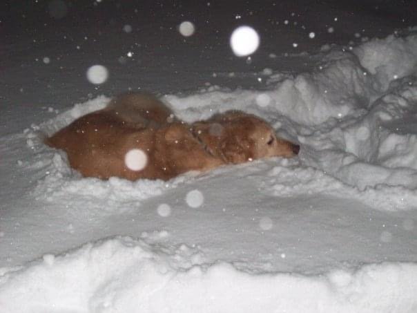
That was Tuck, picture is from the end of the storm after 20in. He was standing and was just kinda stuck. Have a lab now, named ‘Thunder’ lol. He has never seen snow, can’t wait for that to happen!
Cool! Our time there at GT may have even overlapped it appears (completed my Ph.D. in 1999, was in the area from 1994-2001). I think I know that bar/restaurant you're referring to right on Piedmont Park, but offhand cannot recall the name. Probably changed hands since then anyhow. I used to live close to that shopping plaza near the corner of Monroe and 8th St., some interesting places there at the time. Also liked the Virginia Highlands area. I haven't been back in many years (too long, I should visit again!), but still have a couple of friends I'm in touch with regularly. We used to get some damn fine martinis over at the Highland Tap (in the VA Highlands area)!
-
1
-
-
12 hours ago, GATECH said:
Happy Anniversary @mappy! Dec 19 was one of my favorite DC snowstorms, seen them all since 1998 when I moved to DC, something about a Blizzard just before Christmas was magical though! Plus I was hammered Blizzard eve at my work Christmas party, stumbling home as it was starting...and yes the snow was up to my Golden’s eyeballs that evening!
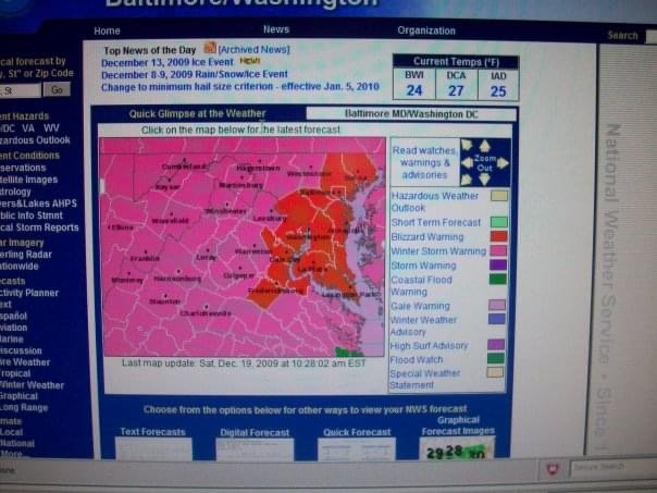
Great screen-capture of that! I saved a bunch of stuff from all those storms that winter, mostly model data.
Cute dog, by the way! Hard to tell if he's playing, or lying there comfortably thinking "now *this* makes a nice bed!!"
BTW, was curious and meaning to ask when you were at GA Tech (going by your name here!)? I went to grad school there, long ago last century in the late '90s, and continued living in the Atlanta area afterward until 2001 when I moved up this way. Really liked Atlanta for the most part, to be honest! I've told people that it's not exactly what one would call a "tourist town", but if you live there, you know the places to go! Ran the Peachtree a few times, too (could never do that again now, haha!)...nice to have it finish practically right in my back yard when I was living near Piedmont Park! Alas, all my fine Peachtree T-shirts are now gone, having worn out some time ago! Might still have one of those long-sleeve ones from the GT 5K run around campus that they had every November.
-
1
-
-
Happy Anniversary to you, @mappy!!


January Medium/Long Range Disco Thread
in Mid Atlantic
Posted
Don't know... It might be fleeting and not very 1996-like?