

Scarlet Pimpernel
-
Posts
7,346 -
Joined
-
Last visited
Content Type
Profiles
Blogs
Forums
American Weather
Media Demo
Store
Gallery
Posts posted by Scarlet Pimpernel
-
-
59 minutes ago, snowfan said:
Yoda is a bot programmed to give pbp for every model run of every model.
@yoda might possibly reply: "Mmmmm! Model pbp or model pbp not! There is no bot!"
(ETA: "Mmmmm, poet I am!")
-
37 minutes ago, yoda said:
Really? Does the rain stay mainly on the plain? @MN Transplant bad joke there good sir

"Heavens, what a sound!!"
-
 2
2
-
-
4 minutes ago, WxUSAF said:
I’ve only looked at posts this morning so far, but seems the models runs are all bouncing within a certain range and we pretty much know what that is. I81 crowd probably is shellacked in any scenario. I95 crowd probably mixes in every scenario. Eastern shore down to RIC is mostly rain in every scenario (sorry friends). Everything I see suggest almost all of LWX gets a WSW. I’ll also say that I’ll take my sleet and rain Wednesday evening and say “thank you sir may I have another!?” if it means I get the kind of deform band that is being advertised.
Agree. This is a very good overall summary. And I'll also take this opportunity to thank @MillvilleWx for the amazing discussions (even when on mids...not to be confused with meds!!
) as well as @MN Transplant, @psuhoffman. Thanks for keeping it real and civil, regardless of what each model run shows.
With a little luck where I'm at just on the northwest side of the beltway, it will be more sleety than rain through that time later Wednesday afternoon. I'm intrigued by the after-00Z Wednesday evening into late Wednesday night timeframe as well, if that deform band produces. Nobody around I-95 should be expecting a foot-plus, but a decent warning-level event seems quite possible. Which is far more than many of us have gotten in nearly 2 years.
-
 4
4
-
-
Just now, Scraff said:
King Euro better not rain our snow parade.
Of all the 3 "main" models, the Euro is perhaps the most iffy, so to speak, for the metro areas and southeast. But even with that, it's still been a pretty solid hit or better (depending on location of course)...and not far from the GFS and CMC.
-
1
-
-
Here's how the last couple days of model runs seemed...
--00/12Z GFS: Total beat-down, pummeling, crushed!
--00/12Z CMC: Hold my beer...!
-
2
-
-
8 minutes ago, Ralph Wiggum said:
I've traveled in time to Thursday evening and back. Congrats Boston.
You don't have to even travel ahead in time (DeLorean or not!!) to likely be correct on that one!
-
1
-
-
2 minutes ago, Always in Zugzwang said:
The days are getting shorter as we approach the solstice. So 5 more days is actually less than that!!
1 minute ago, WxUSAF said:GFS gets snow in at like 118hrs. That's Day 4 sucka.

-
Just now, H2O said:
I think its safe to say today's model runs will hold for.....checks calendar...5 more days
The days are getting shorter as we approach the solstice. So 5 more days is actually less than that!!
-
3 minutes ago, WxUSAF said:

Hopefully in a couple of hours, we can also sing "God save the Queen!" when the Euro comes out!!
-
1 minute ago, H2O said:
I need to get my travelors checks for my next vacation in 2022
Just be aware of the traveler's advisory!!
-
1 minute ago, losetoa6 said:
P03 for Monday blown up for your viewing pleasures

Is that how fuzzy it looks after a few of those beers in @Scraff's fridge??
-
3
-
-
1 hour ago, WxUSAF said:
^keanuwhoa.gif
Based on the maps I’ve seen, Eps looks really really nice. Cold and with a more southern transfer to the coast than the Op. Getting tingly.
OK, I admit...it took me a moment to realize what this said. At first glance, I thought it might be some kind of Hawaiian way of saying "Holy Sh*t!!" But I guess the meaning is the same regardless!!
-
2 minutes ago, Ji said:
watch our 12 inches all melt on Dec 24th at 11:48pm
<RR> There are medical treatments for that nowadays. </RR>

-
1 minute ago, Maestrobjwa said:
Hey Beethoven...ya know this would end up your 250th birthday right?
(December 16th is the estimated day!)

-
 1
1
-
1
-
-
4 minutes ago, WxWatcher007 said:
It’s easy to get caught up in the verbatim but you look at the players on the field and there’s no way I’d want a scraper look 6 days out with that blocking in place.
Give me wiggle room if that high is analyzed stronger closer to game time.
Exactly...essentially what I'm thinking. And even taking it verbatim with the (silly) snow maps, I take heart in the fact that a couple inches still gets into the cities, with a bit more where I'm at on the northwest side of town.
As has been said, get that primary to transfer sooner, rather than when it's up near the OH River, and a lot of people would be quite happy (with the possible exception of Ji, hahaha!). I haven't really been looking at this in detail until just the past day or two, but has the transfer of energy trended one way or another over time?
-
8 minutes ago, mattie g said:
Interesting to see a non-bombed-out low out bully its way into a high like that with blocking in place.
edit: Good track, though, so I suppose it's more about cold than the block.
Yeah. More an issue of the primary that's along the Ohio river it seems, messing up the thermals. As others indicated, if the transfer is quicker, or if the primary doesn't go that far north, that could do it for us. But not a bad overall look to have a week out. Will be interesting to see what the ensembles show...
ETA: You know, even just going with the crazy snow maps (not worth a lot, I know!), about 1-2" snow still manages to get down into the cities and DC area at the end, with obviously much more as you go north and west. That's 1-2" more than we saw the other day!
-
1
-
-
1 minute ago, North Balti Zen said:
Also, I have yet to see one snow flurry this year.
Yup...seen lots of flakes, but none of them are of the snow variety!
-
40 minutes ago, WxWatcher007 said:
Coming at Frd for that? Come on, y’all. Weenie la la land is how you end up in one of my padded rooms.
You've got padded rooms in the Panic Room now? Whoa...that might be a game changer right there!
-
Just now, WxUSAF said:
That’s just seasoning. It’s the maple syrup on the Canadian pants tent.
Careful, you might invoke RR with that comment!!
-
1
-
-
2 minutes ago, Snowchaser said:
This is straight up porn!
Can't be right, simply because it has a relative minimum over the @Bob Chill jackpot zone in MoCo!!
-
31 minutes ago, DCTeacherman said:
Welp, back here for another winter of tracking. I believe this is my 14th winter tracking storms on the internet. This year I'll need more distraction than usual because my wife died back in August and now I'm a single parent of two small kids (2 and 4)
 . Hopefully mother nature can throw me a bone.
Echoing what others have already said...very sorry to hear this and my condolences to you. Take care of yourself and your kids, keep them close. And yes, hopefully we can get some snow to brighten things for you at least a little.
-
8 minutes ago, psuhoffman said:
Most haven’t had a snowstorm in almost 2 years and they’re gonna be picky lol If a hot air balloon went overhead flown by a pilot with a bad case of dandruff I’d call it a win at this point.
Yup...January 2019 is what I assume you're referring to from "almost 2 years ago". And anything would beat the 1.5" slush that I got last year for the "largest" event (and about 2" total for the season, woo-hoo!).
ETA: Oh, and I think some people forget just how bad it was in December 2015, when we had a +11 degree departure from normal for the month. Just let that sink in for a moment. Eleven. Degrees. Above. Normal. When it's unpleasantly muggy and damp on Christmas Eve, you know December sucks. Thank God that kind of departure didn't happen in July!
Of course, a few weeks later we had a storm for the ages, but anyhow...
-
1
-
-
1 hour ago, mappy said:
Yeah @losetoa6 mentioned that in the short range thread. I’m okay with a quick hitting heavy rainer if it gives chance for something early next week. The light dusting I got yesterday has me jonesing for more
I hear you on that! Would be nice to not trash the entire weekend with more rain, rain, rain (not like we need more terribly much!)...have that move out quickly and potentially allow some chance of snow early next week (even if small), would be great about now.
-
1
-
-
1 hour ago, psuhoffman said:
P27 and call it a winter
Ha! I was just about to write the same exact thing!
(ETA: Well, almost...wouldn't really want to "call it a winter" after that in December. But I know what you mean!)

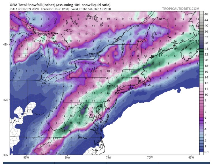
December 16/17 Winter Event
in Mid Atlantic
Posted
Looks quite similar, going by the overall "shape" and coverage. Biggest difference is that the amounts are noticeably bumped up (whatever it's worth, on these maps!)...presumably due to the enhanced CCB at 12Z vs. 06Z?