

MAG5035
-
Posts
5,718 -
Joined
-
Last visited
Content Type
Profiles
Blogs
Forums
American Weather
Media Demo
Store
Gallery
Posts posted by MAG5035
-
-
7 hours ago, canderson said:
The nam kinda nailed that extreme warm surge. The euro … failed. Again.
I think the more inside track of the low was what allowed the NAM to “nail” the warm surge since the low pressure ended up going right over my head. I bottomed out at 981mb this morning a few hours ago, probably the lowest MSLP around here since Hurricane Sandy. The low coming in this far really didn’t become evident on guidance until the near term yesterday since the consensus had generally been curling the rapidly deepening low into eastern PA, not dead center in the state. That was enough of a difference to not only allow a changeover to rain but also get some of the heavier rain and wind tapped down with the occluded frontal passage before the dry slot into the Sus Valley. NAM never really saw the half decent front end snows in the LSV until it was already happening. All models weren’t cold enough at the beginning of the storm either from the Laurels eastward in the state.
-
 3
3
-
-
2 minutes ago, kerplunk said:
Had 5” of nice powder before mixing with sleet sometime around midnight. Thankfully got dryslotted around 1am and still eyeballing 5” so not much compaction. Temp at 29.1
There some regeneration of precip on radar down this way and it’s straight light freezing rain, so now the pack is crusted over already.
-
3 minutes ago, MikeB_01 said:
Dry slot life. The worst.
Finally seeing ours fill back in over PGH
Yea I think you guys will still salvage some more snow even though the best deform ended up NW of the city. It should still swing back through some as the storm lifts up out of central PA overnight and probably rebuild some. Definitely been a fascinating storm to watch.
-
Temp is up to 28ºF now, pressure is DOWN to 987mb. Living the dry slot life currently.
-
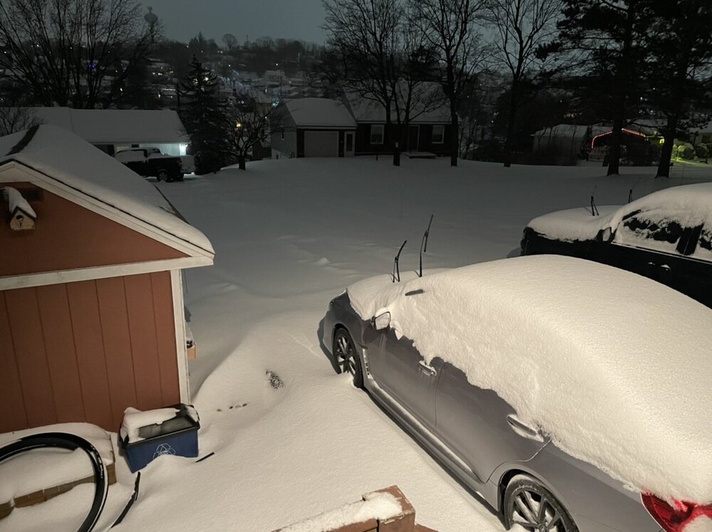
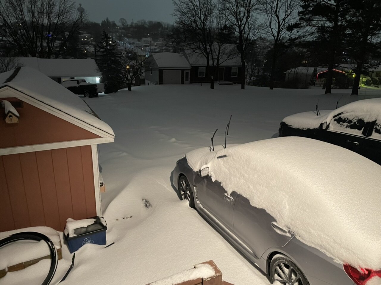
Also, here was a snow pic right at the sleet transition a bit ago. There actually had been some half decent drifting.
-
CTP did hoist wind products (advisory for 15-25 gusts to 50mph) for good portion of the area in the wake of the system tomorrow and incorporated wind impact into the ongoing warning in the Laurel’s. Also didn’t completely rule out needing a blizzard warning there tomorrow either.
Per short term portion of the discussion:
QuoteStrong gradient in wake of departing low and a strong isallobaric couplet noted in model data Monday, particularly across the southwest part of the forecast area. Bufkit soundings in this part of the state support gusts in excess of 40kts, so have hoisted a wind advisory and incorporated the winds into the WSW over the Laurels. These winds should produce considerable blowing/drifting across the Alleghenies with locally poor visibilities on Monday. Not convinced that there will be frequent 1/4sm visibilities because the snow will be much lighter Monday. However, wouldn`t rule out the possibility of needing to upgrade to a blizzard warning over the Laurel Highlands Monday.
-
32 minutes ago, canderson said:
Didn’t have that on my bingo card tonight.
That line could be the mechanism I mentioned yesterday that would be needed to tap the high low level winds and provide some semblance of the high surface wind gusts that models like the GFS have been showing a lot leading up to this. Will have to keep an eye on it the next couple hours to see what sneaks up into the LSV. Specifically this portion.

-
1
-
-
Ping Ping. Going to be clearing boards at 5.2” so far.
Sleet with 21ºF, winds NNE 7 G14, and pressure crashing now down under 996mb.
-
Starting to flirt with the mixing zone on the CC product. Still all snow for now but will see when the next patch of brighter echoes get here shortly. HRRR has been pretty consistent on an approx 11pm transition to sleet here so that’s probably looking pretty good. Also starting to get near the dry slot as well, though I expect some rebuilding of echoes to a degree.
-
Gorgeous storm

-
1
-
 1
1
-
 1
1
-
-
Right around the 4” mark now, with moderate to heavy continuing.
Temp has been rising but still in the teens (19.4ºF), Pressure down to 1002mb.
-
One thing I’m noticing on the meso surface obs is that most ASOS stations have winds of a NE component to them in central/eastern PA, and even all the way down in all of Sterling’s CWA. So that’s likely to at least hold some surface cold for awhile. Sleet will probably be a more predominant mix type for a while after transistion as it will take some time to modify 925mb.
-
1
-
-
M 2.4”, Heavy snow.
Temp has torched to 14.2ºF lol. Wind NNE 5 G 8, Pressure 1007mb
-
2
-
-
I was past the first inch when I measured about 20min ago.
Heavy snow, 13.1°F(!!)/ 10.8°F
This is the coldest synoptic event I’ve seen in years
-
4
-
-
Snow has begun here in the last 15-20min with a dusting. 16.5ºF/2.8ºF
-
1
-
-
8 minutes ago, Bubbler86 said:
Bolded is an important point but not much to explain why Wxbell is higher than TT at the transition zone other than individual algorithms on each suite. Wxbell is the only map I can find that has York City over 4" using 12Z GFS data. Not saying Pivotal is right but Wxbell should not be higher than TT with the same data.
Yea I”m not sure, could be a difference in whatever algorithms they use to generate the p-type too. Because WeatherBell’s winter conditional QPF are all separated now, there isn’t anything lumped with snow accumulation.
-
1
-
-
24 minutes ago, Bubbler86 said:
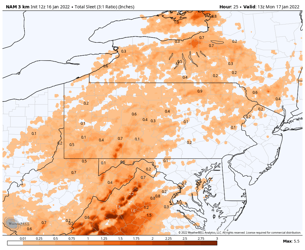
Just watched a video, from 7 years ago, where Ryan Maue explains how the Euro snow maps are done on Wxbell. He did not broach GFS. He said Euro output includes sleet AND Frz and he has an algorithm that attempts to back out the liquid equivalent. So this may explain why Wxbell maps are so different from TT and Pivotal re: each uses their own method. Here is TT for the 12Z GFS and its definitely lower in some areas despite including sleet. Important to know for model PBP. TT also uses the "SLR " which is explained by Ryan also below.
Today's 12Z GFS on TT
Yea being 7 years old that’s right when those WB maps/products first came out. Early on they were known to be really exaggerated on the edges where there was mix like the Tropical Tidbits maps are. TT literally says on their accumulation maps total snow/sleet. But WB changed their algorithms at some point and are a good bit better and I consider it fairly reliable. Gotta remember type of models make a difference too. A global model like the Euro/GFS aren’t going to see the finer details and sharpness with these transition areas.
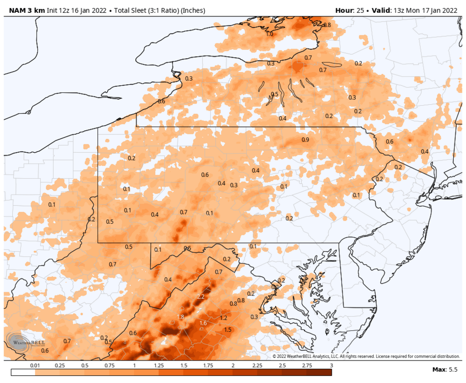
But any rate on Weatherbell all p-types are separated now. if I want a sleet map, I can pull one up. They calculate accum for sleet on a 3:1 ratio for most of the models. Euro has been colder thermally and has had a more of a straight snow-rain transition with little in between in PA. Here’s the 3k NAM’s sleet map.
-
1
-
-
Current obs: Clouded up here. It’ll be interesting to watch the wind and barometer as this storm comes up tonight/tomorrow. Also still pretty dry here with the dew point below zero.
-
2
-
-
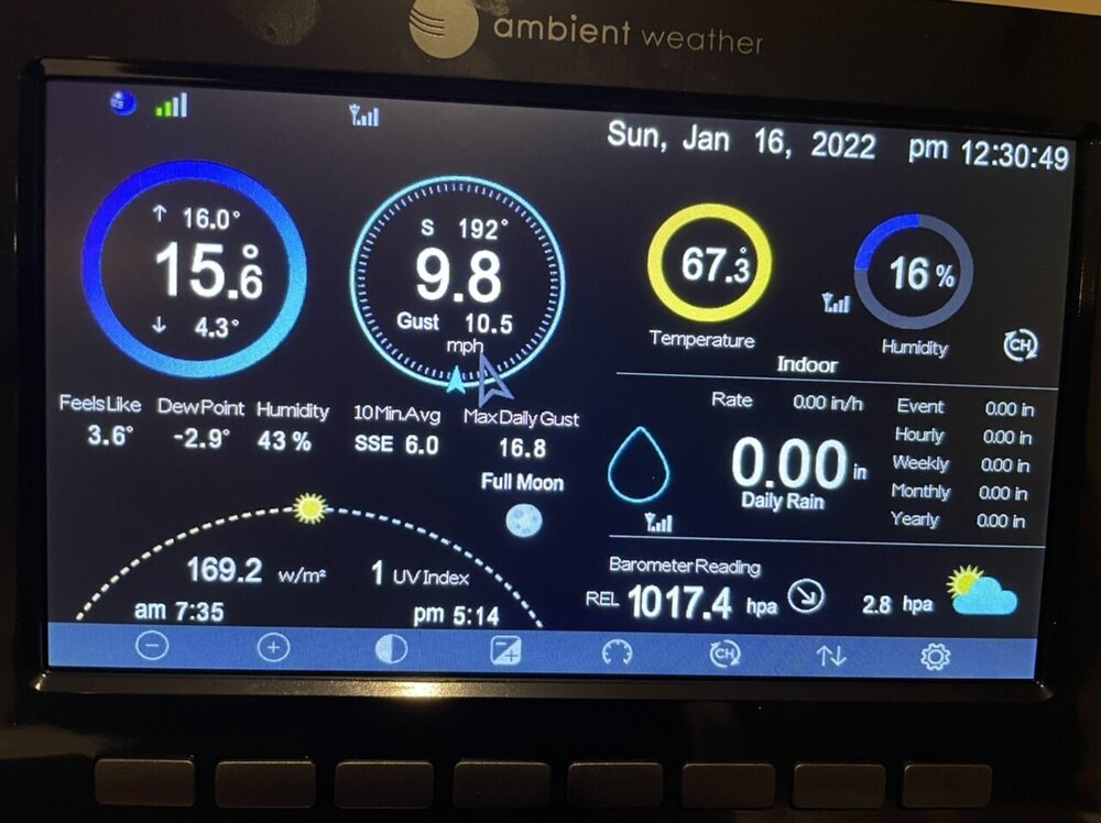
I did follow @canderson ‘s scientific advice last night and install my weather station outside lol.
So currently I got a 16.3ºF temp and a 1.3ºF dewpoint. Should be interesting to see how low it goes tonight.
Only got to 19ºF for a high.
-
2
-
 2
2
-
-
40 minutes ago, Atomixwx said:
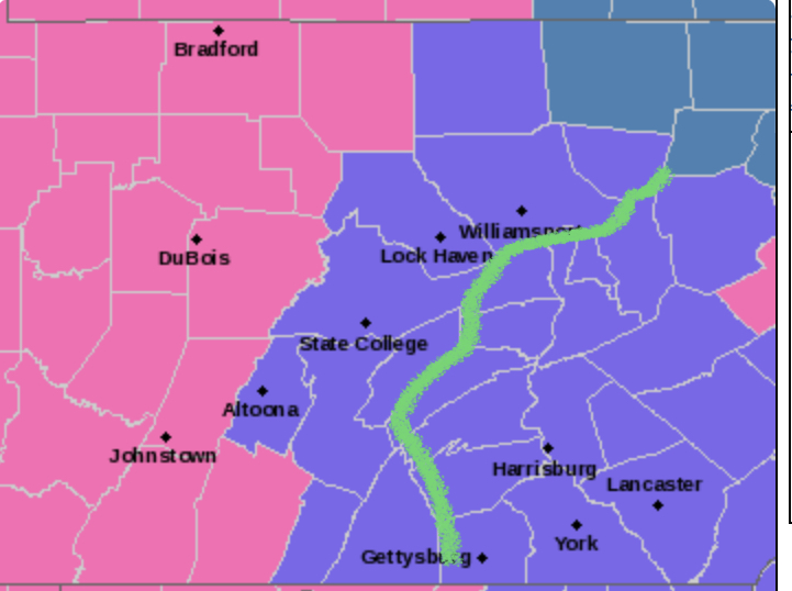
In my experience growing up in SE Huntingdon county and living in the Cumberland Valley and HBG metro, my opinion is that they have the same weather due to being within valleys. Even with ridges (Jack's/Neelyton/Fannettsburg/Kittatiny/Blue mountains) separating the Shade Gaps and Chambersburgs of the world, the valleys generally share the weather as Franklin/Adams/Cumberland/Dauphin counties. As a result, I would understand breaking Fulton/Huntingdon/Mifflin/Juniata counties up into "ridges" and "not ridges" the same way the Pittsburgh office does Fayette and Westmoreland Ridges. Those low-lying areas will likely have similar results to the LSV.
So yeah, I would take that green line of yours and shift it just a tad left and tell the ridge denizens to expect worse lol
Haha yea there are some large valleys in that region and that’s where most of the population resides too. Although on the other hand, this is the general area I expect the potential stripe of freezing rain that’s more than just a glaze to a tenth.
I”m on board with their forecast numberwise (they put a new map out) and a bit of a reduction in accums. I just think the overall high storm impact and still a good bit of overall model support for 6”+ justified a warning for some more of the central counties. Gotta draw the line somewhere I guess. I still expect to get to 6” in AOO/UNV with the amount of mixing dictating the top end potential.
-
20 minutes ago, canderson said:
@MAG5035 has said he doesn’t expect those gusts to mix down and CTP seems to agree. I don’t understand the dynamics of why not myself. CTP is peaking to mid 40s
The stable cold boundary layer at the surface usually keeps higher winds from mixing down that far away from the coast. You would need some kind of convective element otherwise, which is possible I guess given the dynamics of the system. There could be some kind of a line denoting the occluded front right before the dry slot. That’s likely the only time I could see noteworthy gusts prior to the low passage outside of maybe some gusty winds on some of those eastern/northeastern ridges.
Post low passage though? It is definitely going to be windy probably region wide. The Laurel’s might have worse conditions later Monday than during the main synoptic portion with blowing/drifting and some lingering upslope snows.
-
1
-
-
18 minutes ago, Atomixwx said:
Nevermind. They went with WWAs at 3:00 lol
So the majority of Bedford County gets 6-11” and 1 tenth of ice warning while Blair (Altoona) and Centre (State College) have an advisory for 3-5” and 1 tenth of ice? All while my newish grid forecast has 6-12” total. That makes zero sense lol.
My overall take on the afternoon guidance led me to thinking the warning swath would have looked something like this.
-
1
-
-
49 minutes ago, Atomixwx said:
I am warned.
Lol I don’t think I’ve ever seen that lineup of counties with Bedford tacked on before without including the other I-99 corridor counties. They must be concocting a different warning statement for them haha.
-
7 minutes ago, Blizzard of 93 said:
Any thoughts on the triple point look on the Euro?
Its been a pretty common theme with this storm reaching the point of being a mature cyclone when the low center approaches our latitude. This low rapidly deepens going through the Mid-Atlantic region which gives it the look of bending back in as it occludes.
I don’t really have much to add that I haven’t mentioned before, the overall storm track continues to be the issue for the LSV. I still think the warm surge is brief but as I mentioned before the key is going to be the strength/speed of warm air intrusion aloft on a strong low level jet before the surface low runs over some portion of eastern PA. Can the LSV get smacked with a good front end snow before warm air wins out for a time ? Certainly, I think most guidance suggests a period of decent snow up front… but it’s looking more of the advisory variety (general 2-4 maybe some 5” in the western part of the Sus Valley, IMO.
I agree with @MillvilleWxon his take about the Euro, although I have liked it’s overall interpretation of a tighter transition zone. I still don’t buy a super wide swath of measurable ZR in our region with this setup. Certainly in the south its a different story, but as mentioned before the high pressure moves east as the storm makes the turn up and it becomes a boundary driven/cold conveyor belt setup over the initial CAD setup. I see any ZR swath as thinner as I think only the LSV gets 925 and surface routed. And even though the low is close I do not see the ridge and valley region westward getting those levels routed. 850mb might though, so sleet could be more in play there for a period of time. If this ends up colder and we don’t have a quicker transition to liquid/freezing liquid, the dry slot might shut off precip before there’s much QPF as non frozen. Which speaking of…
The other issue, which you could argue is the bigger one in the longer run is the dry slot. Eastern PA is going to slot out with the forecast track and how much that slot gets into the central counties (the UNV/AOO/99 corridor) will factor into what the top end is there. The storm rockets right up, it’s not blocked due east or a cutoff slow mover.. so I don’t foresee a part two snow for the Sus Valley like some of the recent bigger events when everyone gets back to a snow column by Monday morning. The deform will hang in western and perhaps some of central (another thing to consider in the central region with top end)
-
1
-


Central PA - Winter 2021/2022
in Upstate New York/Pennsylvania
Posted
Snowing and blowing as I’m back into some of the backend stuff. Probably been roughly an inch since this morning though it’s been blowing around so I’ll have to see if I can get a decent measurement.
I picked a really good time to have an actual weather station. Some notables.. as I mentioned my pressure bottomed out near 981mb about 5am or so. Temps did edge above freezing from about 230-430am but only made it as high as 32.9ºF. High gust so far is 32mph, but this wind is just getting going.