

MAG5035
-
Posts
5,718 -
Joined
-
Last visited
Content Type
Profiles
Blogs
Forums
American Weather
Media Demo
Store
Gallery
Posts posted by MAG5035
-
-
Euro still doin it’s thing for the most part.
0z vs 18z

-
 1
1
-
-
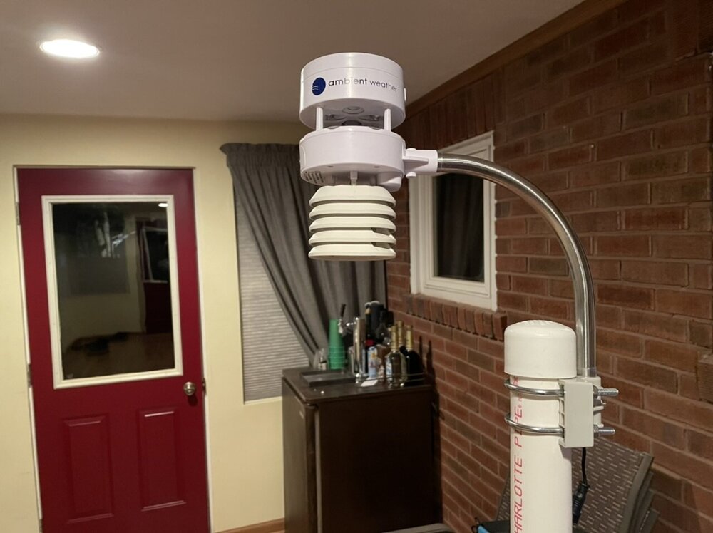
In the meantime I’m trying not to sweat the models too much. I finally will have an actual weather station for obs once I get it mounted and set up.
(No, I don’t have anything on tap at the moment lol)
-
4
-
-
6 minutes ago, Bubbler86 said:
It just saw a post that said the Rgem is similar to the nam. So anyone can see anything it appears.
Lol, definitely not.
It’s not much different than it’s 18z but it ramped totals up in western PA and edged them back up a tad in the central. Sus Valley was still about the same.

-
Sigh, this freakin NAM. Like the literal definition of a turd in the punch bowl lol.
I will say the 3k NAM looks better than the 12k, at least that roughly gets the 2” line to the Susky.
-
15 minutes ago, Bubbler86 said:
Hrrr delaying the transfer and has the primary in WV and still deepening at 7pm tomorrow. The coastal has a reflection but not as deep. Hrrr is still advecting warmer 850's into N VA at that point but a different way of handing this convulted solution.
Despite all that it still looked better p-type wise at 48hr on approach than the 18z NAM lol.
-
12 minutes ago, canderson said:
You think MDT sees more plain rain than zr? CTP seems to now.
Yea, if this does go to liquid at some point in the storm it probably will be with surface temps right at or above freezing. That’s part of the problem with the low tracking inside into eastern PA. The low level flow is ESE and those gusty winds will moderate the surface temps, esp after p-types transition. If this found a way to even mostly stay under PA and go towards Philly or NJ you could have a more ENE flow which could hold the low level temps better. The NAM may be onto something with quicker warmth aloft but it maybe too overzealous with its super strong and far reaching 850 jet. That feature is going to be the key with the front end.
The other part of the problem which has been modeled for days is the surface high setting this cold air mass slides east as the storm tracks up. This transitions initial CAD into a boundary situation where the track of the low will dictate the swath of heavy snowfall and transition zone. If this thing tracked NE right up just inside the coastline the high positioning east wouldn’t be an issue as there is still plenty of cold wrapped into the system.
-
2
-
-
1 hour ago, Atomixwx said:
If it ends up rain up this way, I'll blame myself for moving and bringing the cold rain with me lol
No way up there in P-burg, I’ll happily take that stand and go down in flames if need be lol. Some kind of period of sleet is definitely a real possibility though and maybe freezing drizzle if we slot this far back. I’m still pretty confident in mainly frozen (snow and/or sleet) in this general area here. The low would have to literally track over us or in western PA for me to change my thinking.
-
1 hour ago, KPITSnow said:
Maybe in the central parts of the state, but I simply can’t but it out this way in WPA with this track and I know Mets like MAG feel the same way.
im obviously a know nothing but I’ve never seen that much ice in the NE side of a system like this.
I do feel the same way, but I don’t completely discount the NAM’s robust warming higher up near the 850mb level either. But same stuff as 12z. The money 3hr frames for ZR are 60 and 63. Using my nearest station at KAOO as an example since I’m in the thick of the heavy ZR over here.
HR 60: Surface -6ºC, 925mb (~3k ft) -6ºC, 850mb +2ºC
HR 63: Surface -2ºC, 925mb -3ºC. 850mb back to 0ºC
Even with that basic breakdown at the major layers I look at that and ask what part of that suggests that particular station sees 0.78” as freezing rain? I think something toward a NAM scenario might get a few hours of sleet into the central and *maybe* western counties. But Pitt’s advantage is the 850 low tracks favorably on the NAM for western (and serviceable to central counties) plus overall flow is on the cold conveyor belt side of the low. We don’t have an Ohio Valley low with SW flow intruding in this situation and trying to overcome that with a secondary to the coast. The warm advection comes from the tremendous easterly flow aloft with the coastal low. I can’t really think of a situation in the past that has presented the NAM type scenario of that much mix/ZR into western PA so that would be a new one to me if it happened.
-
3
-
-
7 minutes ago, Bubbler86 said:
Do not have the time to try and crack the code but would be interested to hear if someone can point out that the Nam algorithms are broken or there is something causing it to melt more than it looks like it should from the surface. But like you said, this si all digital and all that matters is the intrusion on the different layers. Both support change over from snow for most of the LSV and near by counties to the West.
Yea, ultimately unless this low track can bump east to at least maybe tracking through Philly.. the big thing for the LSV is how much can they get up front as that region is going to be subject to being advected out all the way to the surface with strong ESE flow from the inside tracking low, with York/Lancaster being the most vulnerable to an earlier transition. It was my original presumption that if this low was going to stay on the right side of the Apps that we would see the best pressure falls closer to the coast and the low pressure doing the same. That late shortwave dropping down from the Lakes does kind of force this thing’s hand to come straight up instead of escaping east or northeast, so hopefully we can see that. There is still time.
-
We can debate how far into PA the warm air aloft punches but I simply do not buy the NAM’s expansive freezing rain. This isn’t really a setup for a deep swath of ice IMO, the high moves east as this storm approaches and this becomes a matter the low track and the cold boundary. The mix period will come and depend on how far in the screaming 850mb jet adverts >0ºC air aloft. 925mb and surface eventually will get compromised for a time too in some of the LSV (esp further south and east) which will probably invite a change to rain but that could be after best precip.
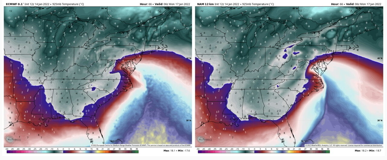
Let’s go on a deep dive, we’ll do the Euro and NAM side by side.
Surface

850mb winds

850mb temps

So okay the NAM has a stronger 850mb jet deeper into PA and more robust advection. Let’s look at 925mb temps.

Look how cold the 925mb layer is, no way that is a widespread ZR profile. Surface temps from KAOO west to Pitt are still in the mid 20s in this frame. We could be talking more widespread sleet maybe at some point in the storm if the more robust warming aloft of the NAM comes to fruition but not straight heavy freezing rain from H-burg to Pitt. This strong 850mb jet and inside low track has been a concern of mine, but to counter this the storm is progressive. There’s no blocking up front to slow this down/cut it off and add more time to advect in warm air. This storm is also deepening pretty decently as it is approaching us so that warm nose will get however far it gets into PA but then as the low gets into (or hopefully just SE of PA).. the maturing system will be cooling the column top down. This whole event’s in about a 12 to maybe 18hr duration range.
-
7
-
 4
4
-
-
I saw this gem shared on my F-book feed. S&S needs to get their head in the game lol

-
 4
4
-
-
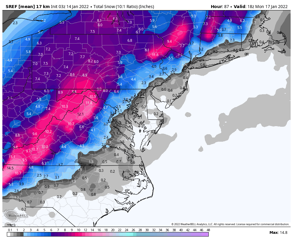
6z NAM pretty similar to the 0z NAM still, but here's a look at what the 3z SREF had. Very similar to the Euro ensemble

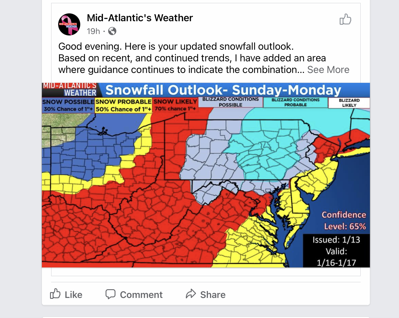
Additionally, PBZ and CTP already have just thrown up winter storm watches for large chunks of both CWA's... likely a hat tip to continued high confidence in most guidance of significant snow in at least the central and western counties. CTP's watch area looks like pretty much everything from the Susquehanna mainstem west. Below is the watch for central/south central counties, north central's is tied in with the Wind Chill advisory and no mention of mixing. No early morning update yet in the CTP AFD regarding the storm.
QuoteNational Weather Service State College PA 405 AM EST Fri Jan 14 2022 PAZ019-025>028-034>036-045-046-049-050-056-063-064-150000- /O.NEW.KCTP.WS.A.0002.220116T1800Z-220117T1800Z/ Southern Centre-Blair-Huntingdon-Mifflin-Juniata-Bedford-Fulton- Franklin-Southern Clinton-Southern Lycoming-Union-Snyder-Perry- Cumberland-Adams- Including the cities of State College, Altoona, Huntingdon, Mount Union, Lewistown, Mifflintown, Bedford, McConnellsburg, Chambersburg, Lock Haven, Williamsport, Lewisburg, Selinsgrove, Newport, Carlisle, and Gettysburg 405 AM EST Fri Jan 14 2022 ...WINTER STORM WATCH IN EFFECT FROM SUNDAY AFTERNOON THROUGH MONDAY AFTERNOON... * WHAT...Heavy snow possible. Total snow accumulations of 6 inches or more possible. * WHERE...Portions of central Pennsylvania. * WHEN...From Sunday afternoon through Monday afternoon. * IMPACTS...Travel could be very difficult. The hazardous conditions could impact the morning commute. * ADDITIONAL DETAILS...Snow could mix with or change to ice Sunday night into early Monday morning southeast of I-99 and I-80. A light glaze of ice is possible.
-
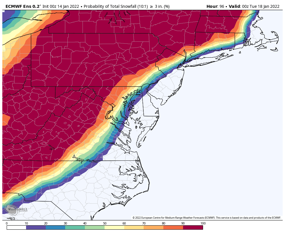
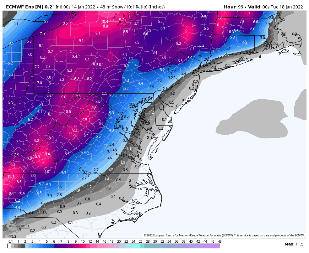
0z Euro EPS
>3” Probs
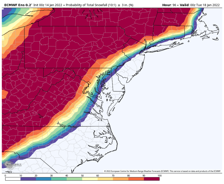
>6” Probs
10:1 Mean

-
1
-
-
15 minutes ago, Blizzard of 93 said:
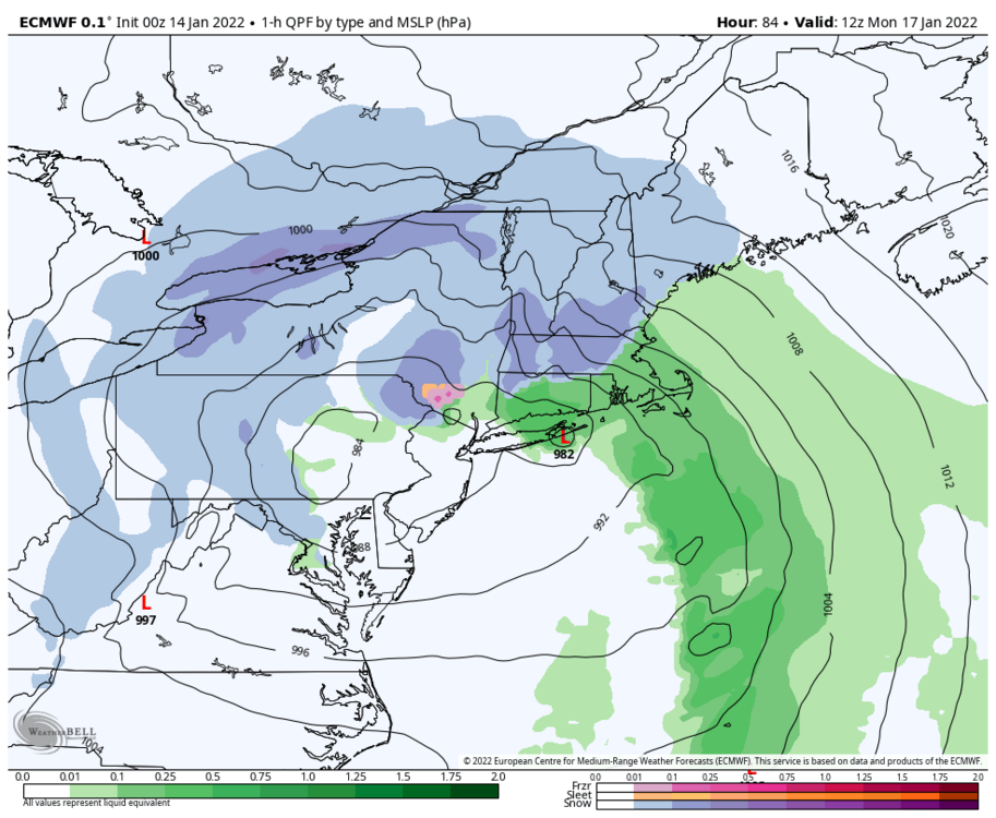
I have a difficult time believing the LSV would be raining as the low jumps to the east at this hour.
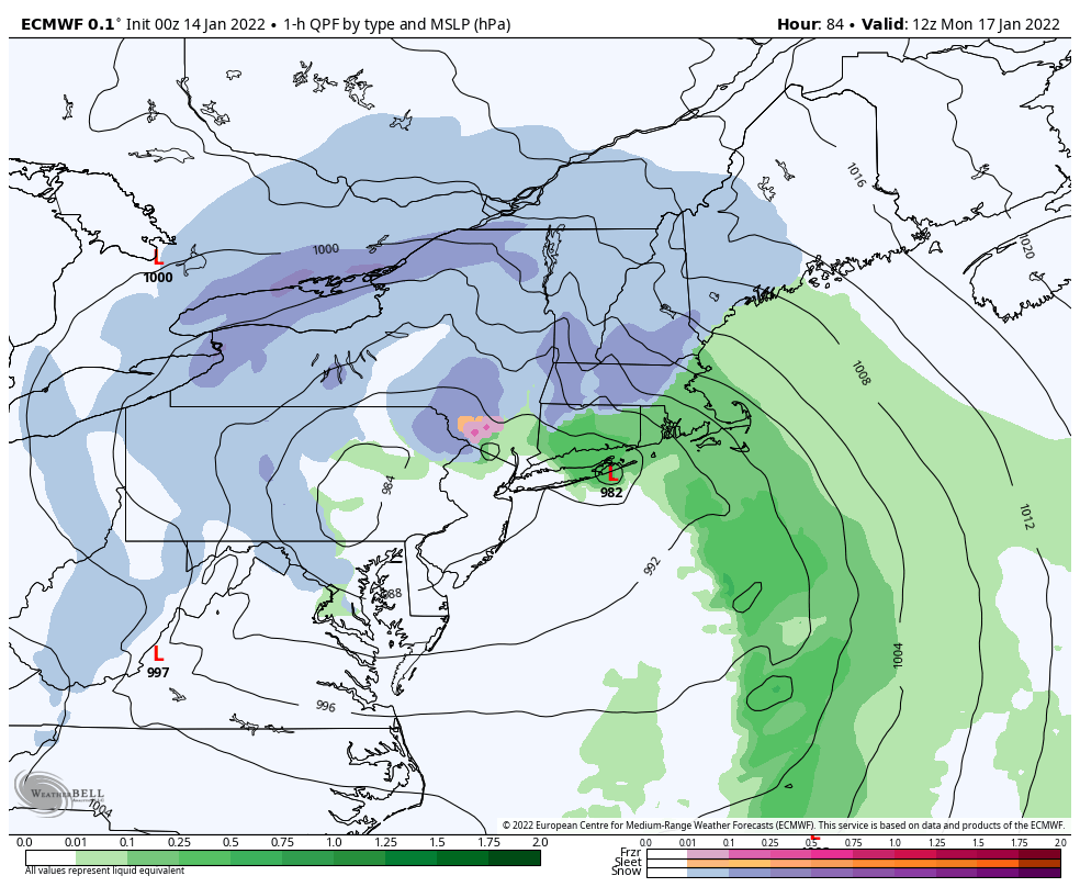
This is in the range where the high res Euro can cover the event hourly. The 6hr precip can be misleading with a quicker moving system. If you use the 1hr QPF by precip type/MSLP you’ll have a much better idea of transition times and precip ending. It looks like most stuff lifts out by about 10am (15z). That track through eastern Penn is rough for the LSV, hopefully it can sneak at least to moving over SE PA/Philly. But even as it looks now the LSV has a 6-8 hour period of snow followed by a transition to rain and then slot out.
Here’s the 84 hr with the 1hr Ptype/MSLP
-
2
-
-
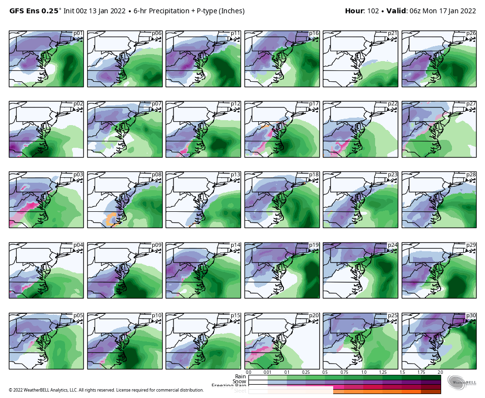
Here was the 0z GEFS 6+ probs.

-
11 minutes ago, Bubbler86 said:
Any potential power outages, maybe not your way but for Pitt fans in the MA and South East PA, could be a minor story.
I’m just not sure winds that high mix to the surface. I could def see some 20-35mph gusts occurring in the Sus Valley pretty easily. I dunno about 50+ though.
-
I’ve been watching the consistent heavy snows on guidance over here and thinking how you couldn’t get any better of a Sunday Night than getting buried while watching the Steelers drop KC on SNF haha. But I’ll be sweating the game and getting the first 6 inches on the ground I’m sure lol.
And on that note, it’s too bad this game wasn’t in Pittsburgh. It would be right in the thick of the storm.
-
2
-
-
NAM really doesn’t differ much from everything else track wise, it might actually be a bit SE of the 18z Euro but there is a big difference thermally aloft. The difference is it seems to want to transport >0ºC 850 and 925mb air much deeper and quicker into PA than the others. NAM might be a bit deeper into PA with it but they all have had this insane 60-80kt+ easterly 850mb jet strafing eastern PA so maybe it thinks that warm layer makes more inroads. Gotta remember we’re in hot take range with the NAM yet but this tremendous easterly jet probably should be kept in mind. I’ll be more interested in the NAM probably say 0z tomorrow.
Speakling of the wind, I have seen the likes of the GFS have stupid high surface winds and I do notice the NAM has similar surface winds in eastern PA. I could def see 50-60 mph surface winds along the coast but that type of stuff doesn’t normally translate to the surface all the way to Harrisburg no matter how windy it is at Canderson’s house lol. I don’t really see that as a good thing if it happens either because besides the obvious wind related issues, the due easterly fetch right from the Atlantic would probably modify the surface and boundary layer. Just some things to keep in consideration. Otherwise, the other ops and ensembles have been pretty solid today and the previously mixy GFS has gotten a good bit more blue with the p-types today so far while the Euro has continued to hammer a large portion of C-PA. I’ll be riding with that consensus unless/until something changes. This event likely will eventually have mixing issues in some of the LSV for a time as I think this will take the inside track but probably closer to the coastal plain and if we’re lucky closer to the Delmarva. But this should hit hard on the front end and the NAM’s probably too far out to resolve that well yet.
-
4
-
5
-
-
Just now, canderson said:
I thought about him earlier today - hope he’s ok.
Wasn’t he travelling somewhere?
-
1
-
-
1 hour ago, Bubbler86 said:
We tossed the Nam about an hour ago. It's GFS or bust right now. I get the finger though and Lanco/York are not going to like it.
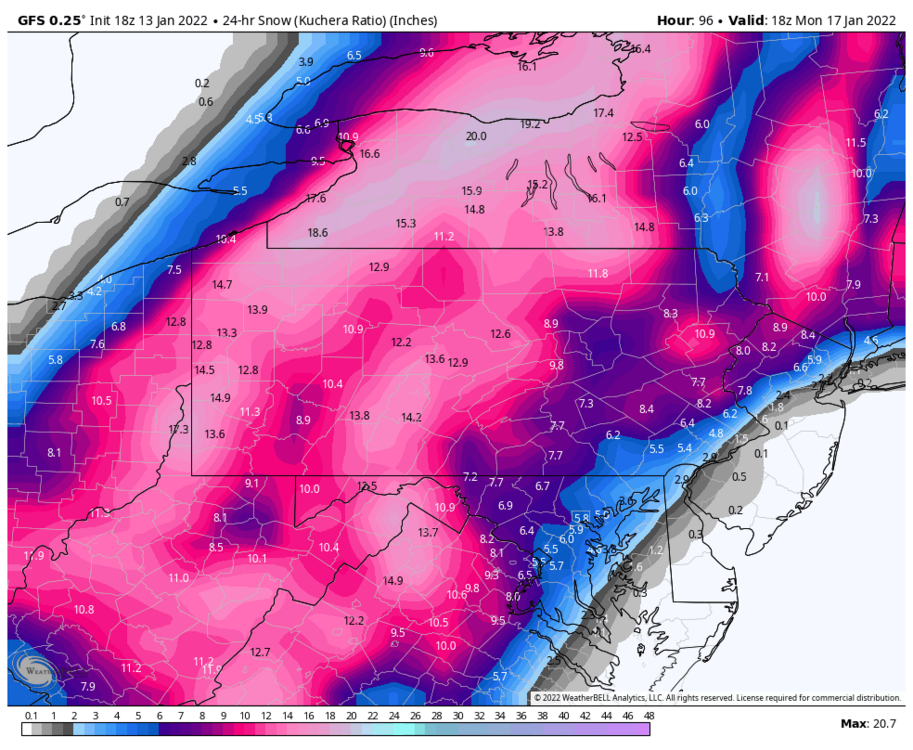
That’s a different interpretation than WeatherBell’s snow map. The GFS on WB has the whole LSV in the 5-7” with no weird reduction like that map. I mean according to that DC is still seeing 6”. If that’s a Kuchera map I wonder if that one (assuming that’s a Pivotal map) calculates it differently. Kuchera is ideal to use in a stable cold snow column. When it’s on the fringes where there could be mixing and/or marginal surface temps (which I’m seeing a good bit of 34ºF in the LSV while still in the main precip) the equation that calculates Kuchera could put out an unrealistically low ratio even if primary p-type is snow. Counter to that, if you have a truly frigid column.. your going to see unrealistically high ratios. At any rate Pivotal and WeatherBell must calculate that differently.
Here’s WB, most of the LSV stuff is right up front. I’ll also note that 10:1 in the LSV is pretty similar to this Kuchera.
-
1
-
-
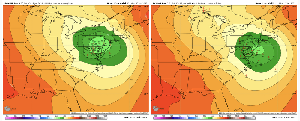
Euro ensemble stuff. Really ramped up accumulation probs in true central and western. Unfortunately also looks like it’s solidified with what the op is trying to sell sending the surface low up into eastern PA.
Accum mean:

Individual surface low tracks (using 0z vs 12z)
-
Might as well throw in the Canadian ensemble.

-
23 minutes ago, canderson said:
The GFS ensemble is posted over in MA. It’s absolute chaos.
Lol it really is though, the snow mean is down across PA (generally 4-6”) but over a majority of it. I assumed there were several members following the GFS op in punching a lot of mixing into PA but I was definitely wrong in that assumption. I see like one such member, the rest are snow and some don’t really hit PA. Good news I guess is that there isn’t any members that are trying any funny business like making the low more dominant on the other side of the Apps.

My educated guess is that the operational models are presenting this system as stacking and occluding as it arrives into the Mid-Atlantic region and giving the models fits in terms of the temp fields aloft and p-type and just evolution in general. For example, I simply don’t see the whole western part of the state sleeting like the Canadian has with the intense precipitation. I would imagine this should be more of a case of how far inside the tracks and how far in the low level warmth punches. And again, this warm punch is brief and happens after the main initial slug of precip. The storm is stacked with the really deep 500mb low moving overhead and should rapidly reestablish a snow friendly column, even with the surface low over PA. The problem is just with the best total QPF residing with the comma head, which would be west of the LSV with an inside surface low track.
-
4
-
-
1 hour ago, Cashtown_Coop said:
Updated CTP grids carry all snow wording for all se counties so that’s good. Up to 80% sun nite.
CTP is likely playing climo likelihood of this ultimately running nearer to the coastline and ensemble support for now, which is a safe bet. It was also mentioned on their AFD of the antecedent cold in front of the system, which will be quite notable. Just realized my grids here have a high of 16 on Saturday, the day before this rolls up. That’s cold.
With everything now on board, considering the differences between models.. none of them are really terrible for anyone in this subforum. Even though the GFS/Canadian is trying to Miller B this more than the Euro, it still has robust coastal development well before it gets to our latitude, and it still delivers good up front. But with that setup, you have to wonder with such a strong coastal low about how well those globals are handling P-types at this range. This thing’s progged to be a bomb (low 980s) on the GFS and Euro. Thats nothing to sneeze at. I would think that would quickly overwhelm any surge of warm air in the column from a presumptive remnant OH Valley low and present a snow-mix-snow scenario.
-
2
-
1
-


Central PA - Winter 2021/2022
in Upstate New York/Pennsylvania
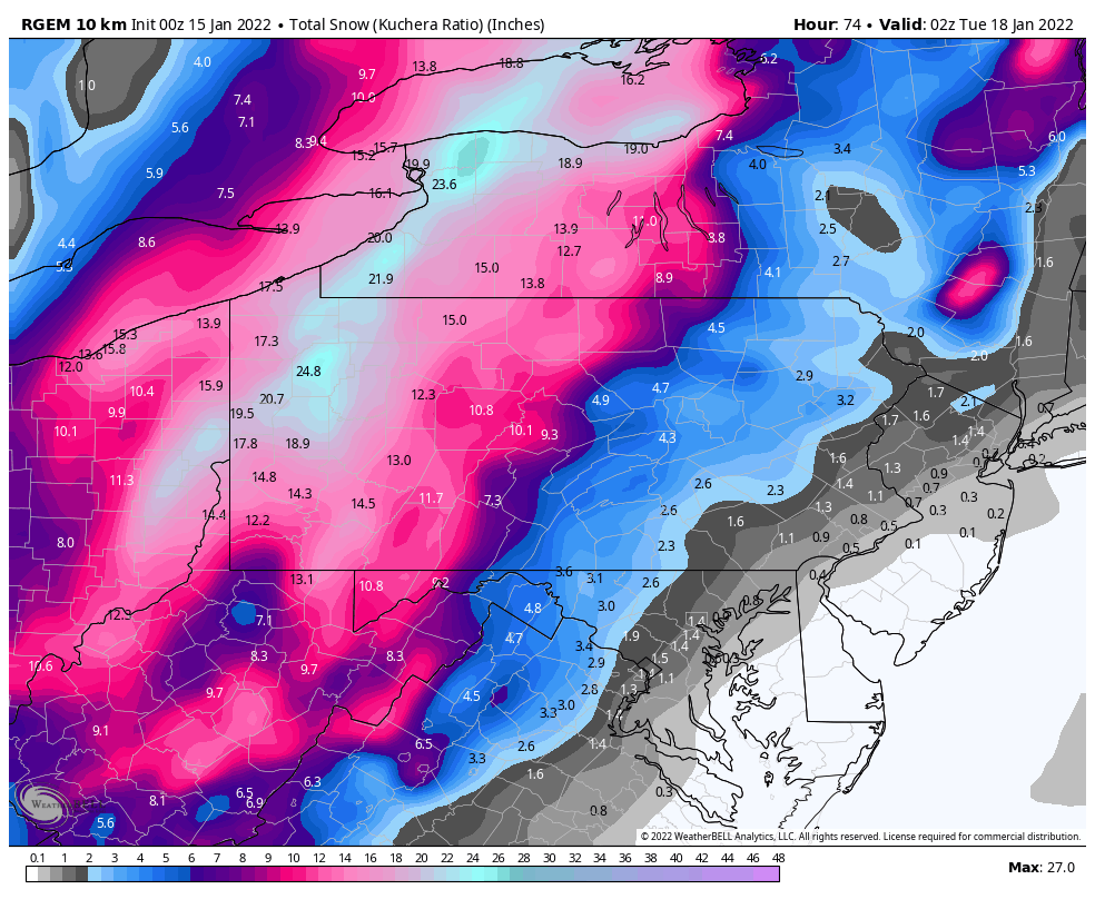
Posted
This is now pretty much fully in the range of the 60hr 3k NAM so the 12k one is dead to me lol. It’s a least a bit closer to the rest of the guidance.