

MAG5035
-
Posts
6,078 -
Joined
-
Last visited
Content Type
Profiles
Blogs
Forums
American Weather
Media Demo
Store
Gallery
Posts posted by MAG5035
-
-
From reaching a high of 84ºF yesterday afternoon to 37ºF and wet snowflakes today. And about 0.8” of rain in between. 3.44” for the month now which is already the wettest month in quite awhile.
-
 7
7
-
-
First 80+ of the year here, all the way up to 82ºF currently on a stiff SW breeze.
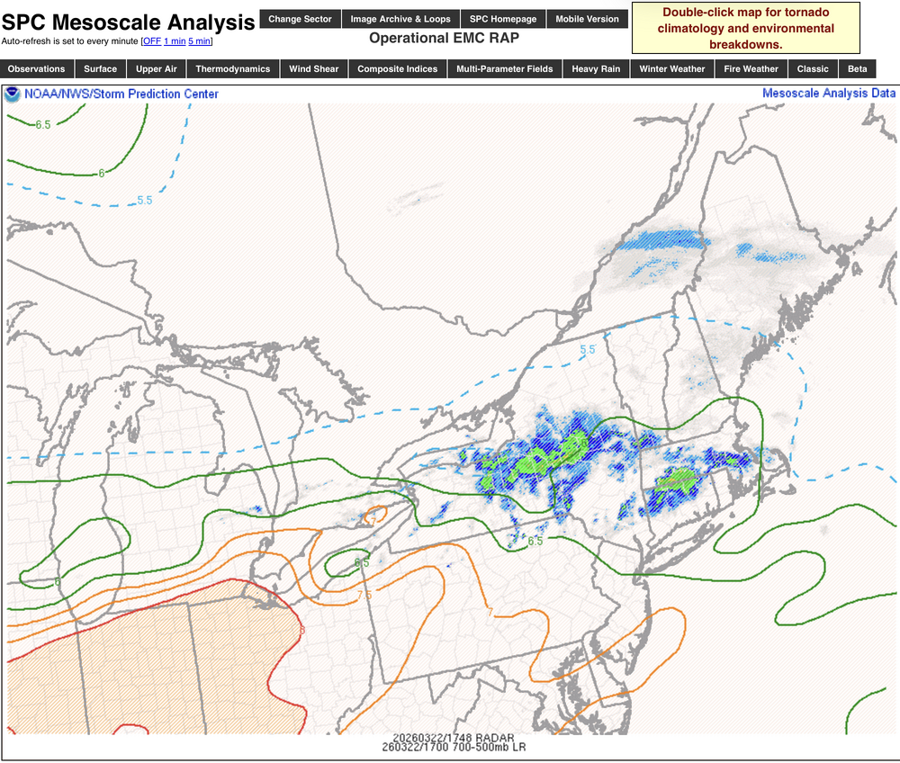
I already like the severe potential today more than the setup last Monday. We don’t have anywhere near the shear/helicity parameters so tornado threat will be more minimalized. Wind and hail will be the primary threats with this.
Regarding CTP disco’s previous concerns about cloud cover, SW and SC PA I-80 and south are fully in the sun and mixed out with the warm, gusty SW winds. So I think we’re going to build some half decent CAPE as the afternoon wears on and also advect in somewhat more moist air. Low and mid-level lapses are very high as well, as noted on the SPC disco. This is the kind of setup that can yield a surprisingly strong line of storms with strong downbursts.
Low Level Lapse Rate:
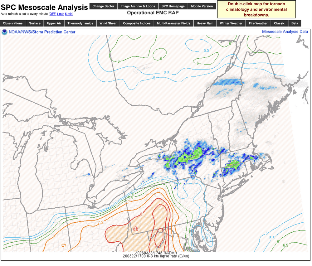
Mid-Level Lapse Rate:
-
3
-
-
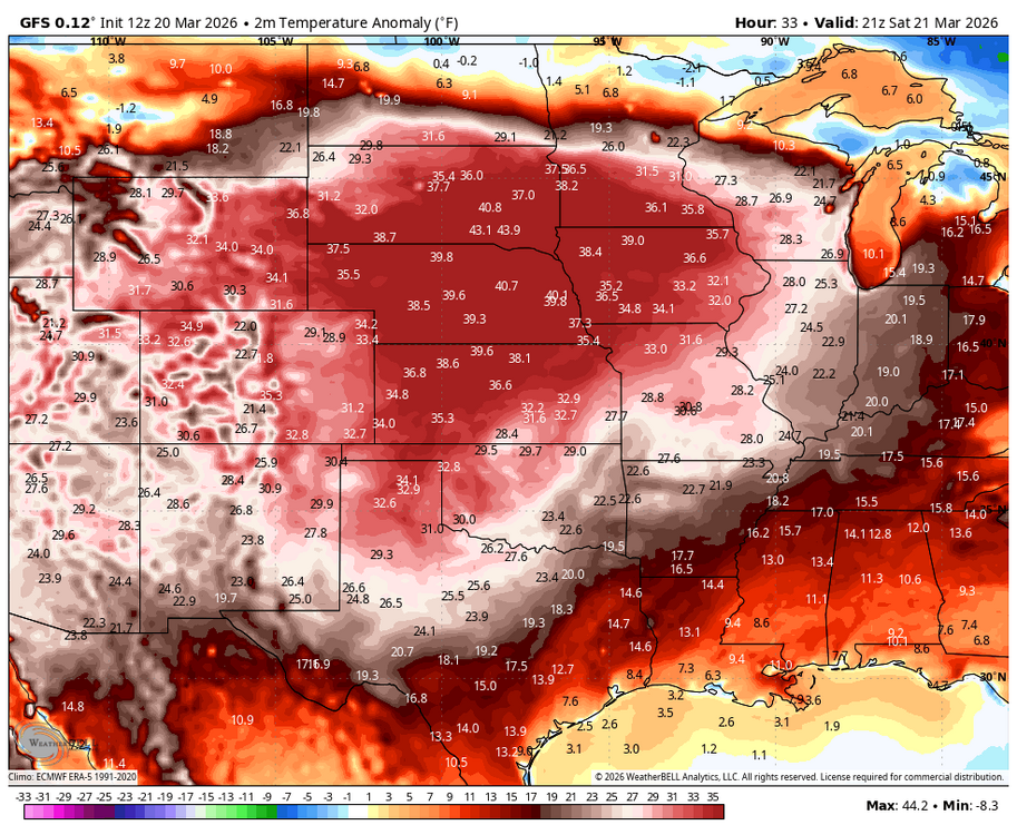
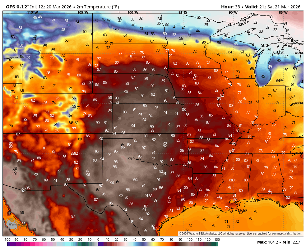
Just your run of the mill +40ºF departure in the central part of the US this weekend. Looks more like 6/21 than 3/21

-
2
-
-
On 3/16/2026 at 4:43 PM, canderson said:
Has the lack of vertical instability on the storms been what caused nothing to bring down the shear winds? We had not much cape but that’s not a need when interacting with shear levels so curious why everything has been muted so much.
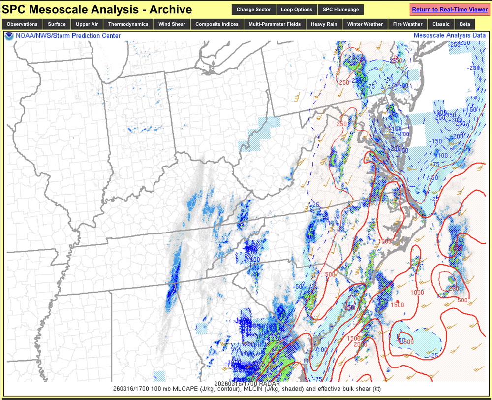
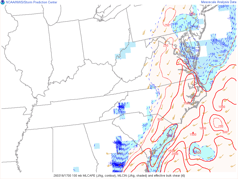
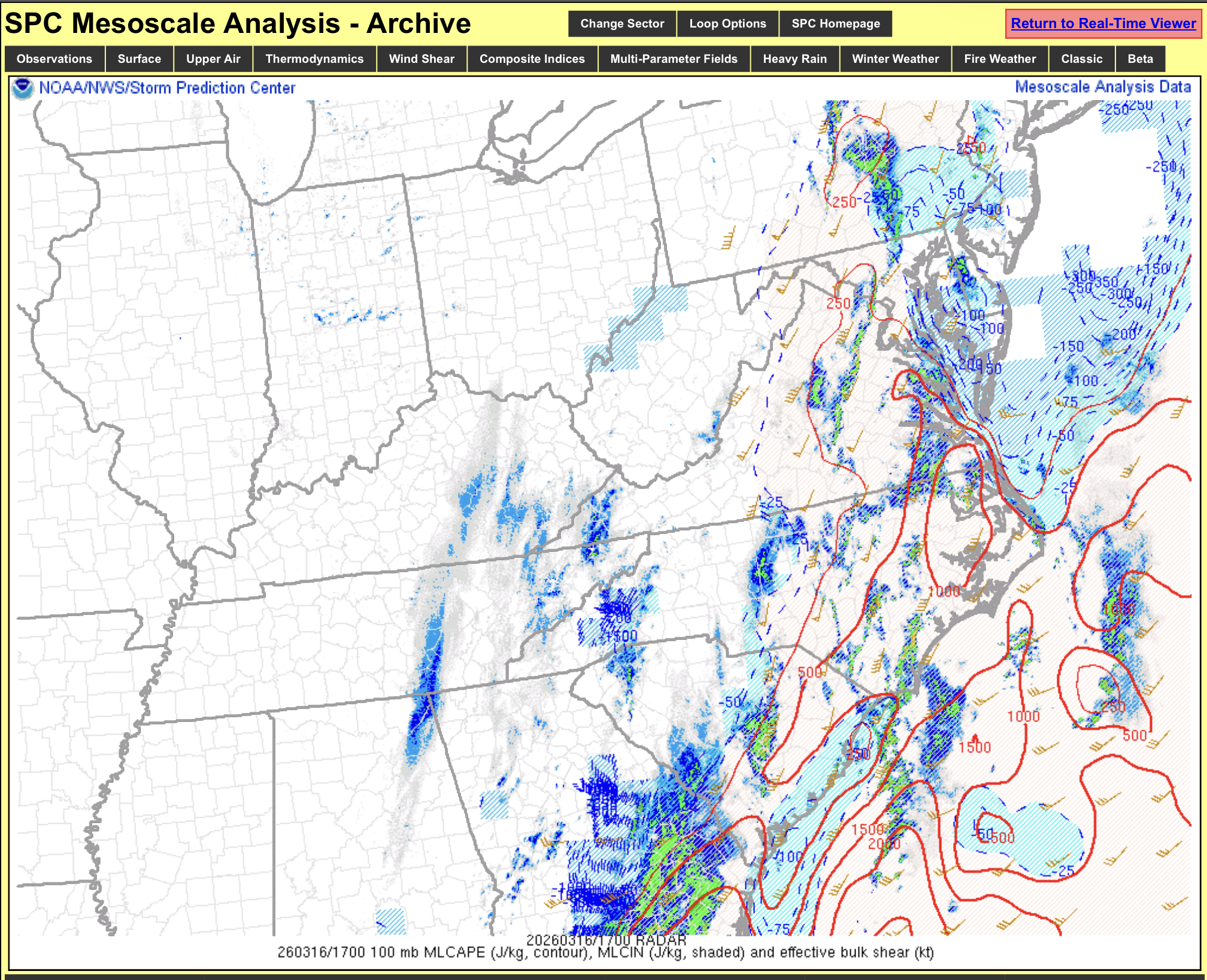
I was looking back at the SPC mesoanalysis from yesterday and parameters were really not all that impressive outside of the shear and low level winds. I just don’t think we had sufficient enough mixing out of the boundary layer or daytime heating (lots of cloud cover) to really tap into much potential. DCAPE’s were only on the order of a few hundred j/kg. Standard CAPE’s were only about 500 or so at best down south where there were still a decent amount of severe wind reports. But I noticed from the SPC map ITT shared up above that they were all of the standard severe wind variety, with 0 tornado or 75mph or greater reports.
Short range meso models were hinting at these limitations some which was why I was reserved on the severe potential a bit. I was still concerned some, I was figuring on a couple spin ups so I’m surprised there weren’t any reports at all. But would I have claimed essentially the weather rapture if I had 243k followers? Probably not haha. If we would have had the air mass we had last week when we were basking in the upper 70s- upper 80s in the Mid-Atlantic this absolutely would have been a much more significant event.
At any rate, more locally mesoanalysis had a persistent area of CIN in the Lower Sus Valley. Low level stability is going to cap transferring the really high winds to the surface. The radars not very detailed on these maps but that was the cluster that popped a couple tornado warnings in MD before it moved into southern PA.
This map is showing mixed layer CAPE (red), CIN (blue dashed), and effective bulk shear (wind barb).
-
1
-
-
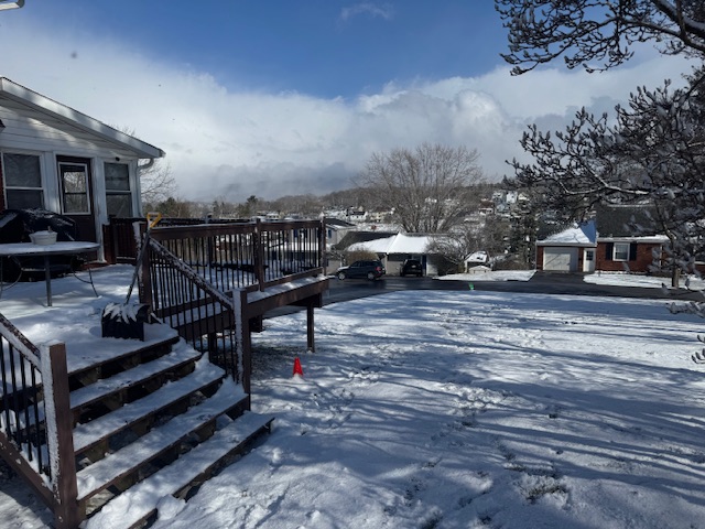
The snow squalls are feisty today. Just had a nice one go through and put down a fresh half inch and take the temp all the way from 29ºF to 22ºF.
The cloud wall in the background is the exiting squall
-
5
-
-
Synoptic stuff is done here. Most things blacktop stayed wet for the most part, but about 2.5” on pretty much everything else. Add some thunder snow and some gusty winds to that and guess I can’t complain about an event like that.
-
4
-
-
53 minutes ago, Jns2183 said:
Thundersnow out south @MAG5035

Sent from my SM-S731U using Tapatalk
Yup, I’m out and about and I saw a lightning strike in Bellwood about 20 minutes ago. I-99 is a pretty rough drive right now visibility wise and the road isn’t even snow covered yet. Very windy with the heavy snow
-
2
-
-
4 minutes ago, canderson said:
Did it push down any wind?
Nah, starting to get a bit breezy now behind the front. Everything’s been under 30mph so far today.
-
1
-
-
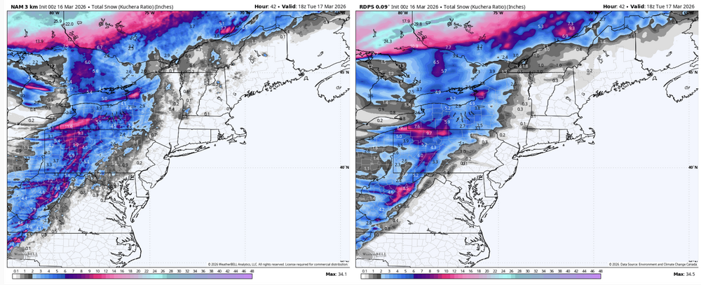
FROPA occurred here around 330pm, temps back to 48ºF. There’s been some regeneration of the line associated with the front itself, in the form of some heavier downpours here. Pressure’s been bottomed out around 992mb for awhile as this is a pretty deep storm system.
Now to try to reel in just the 2nd measurable snowfall in the last like 50 days. Upstream radars at PBZ and RLX (Charleston) look pretty solid. This is probably going to catch some folks off guard tonight.
-
3
-
-
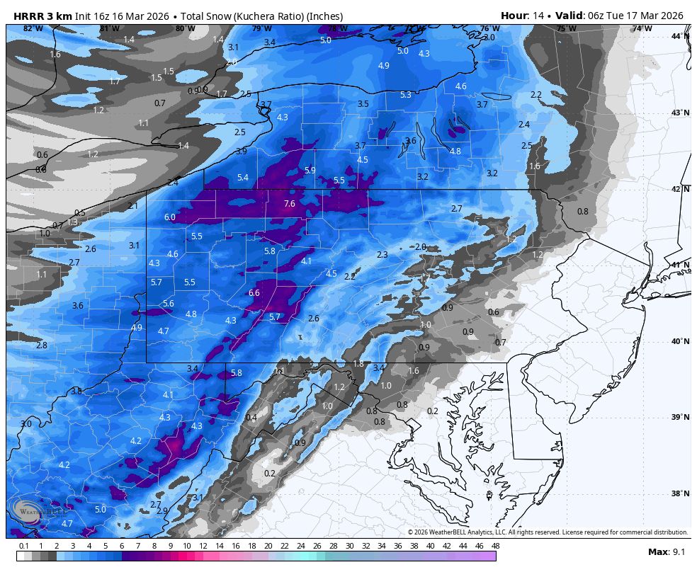
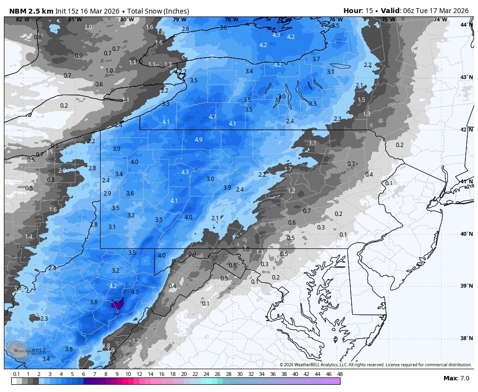
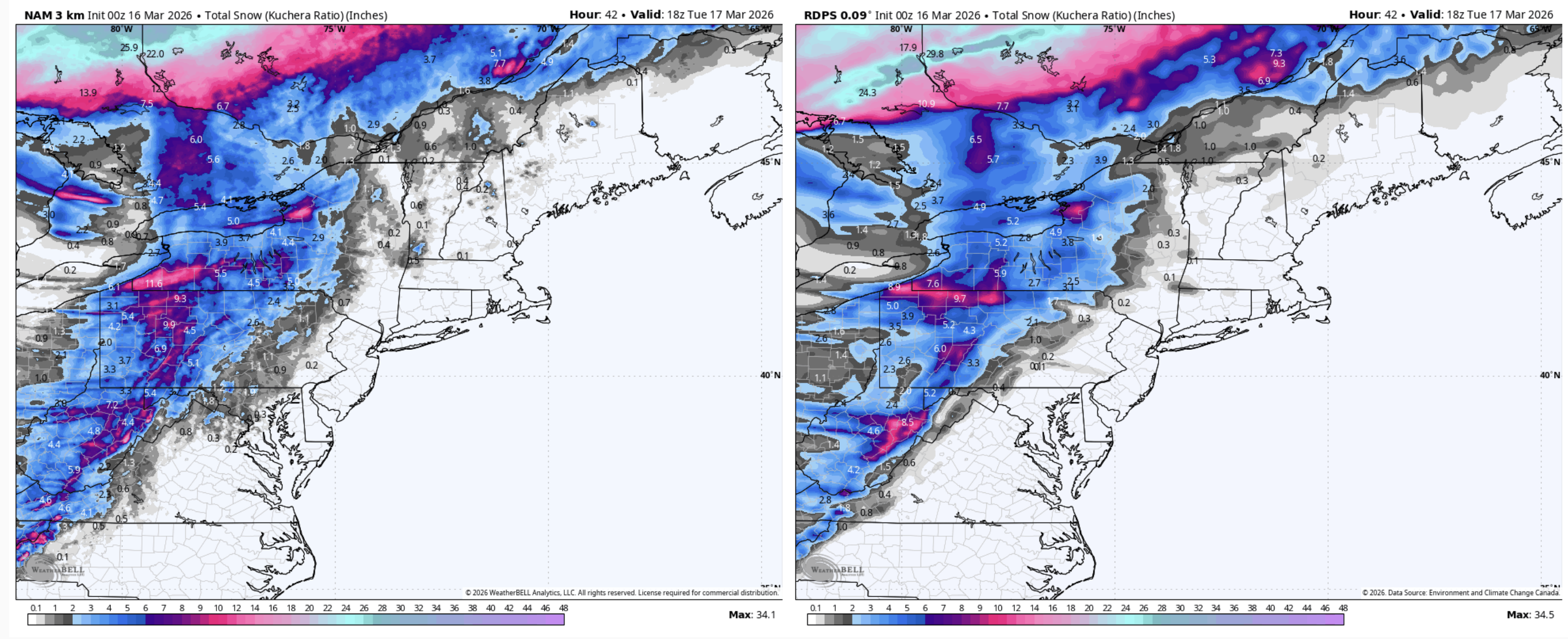
HRRR and NBM snow totals this evening.


-
7 minutes ago, canderson said:
How delayed is that line now? Seems less likely to be a full QLCS later this evening.
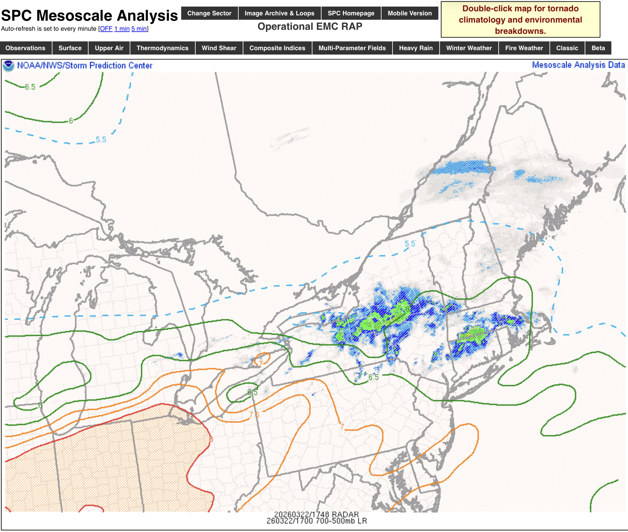
I think the bulk of the overall severe threat is happening right now with that line coming into the Sus Valley from MD and also the other part of the line further up northeast of State College. This was the time of the day the high res models have been surging the CAPE up and matching with the shear. The line with the frontal passage (now east of Pittsburgh) might not have much CAPE to work with.
-
1
-
-
Back this way, I think if the weather rapture were to claim me today it’s going to by the snow and wind that is looking more and more likely this evening behind the front.
-
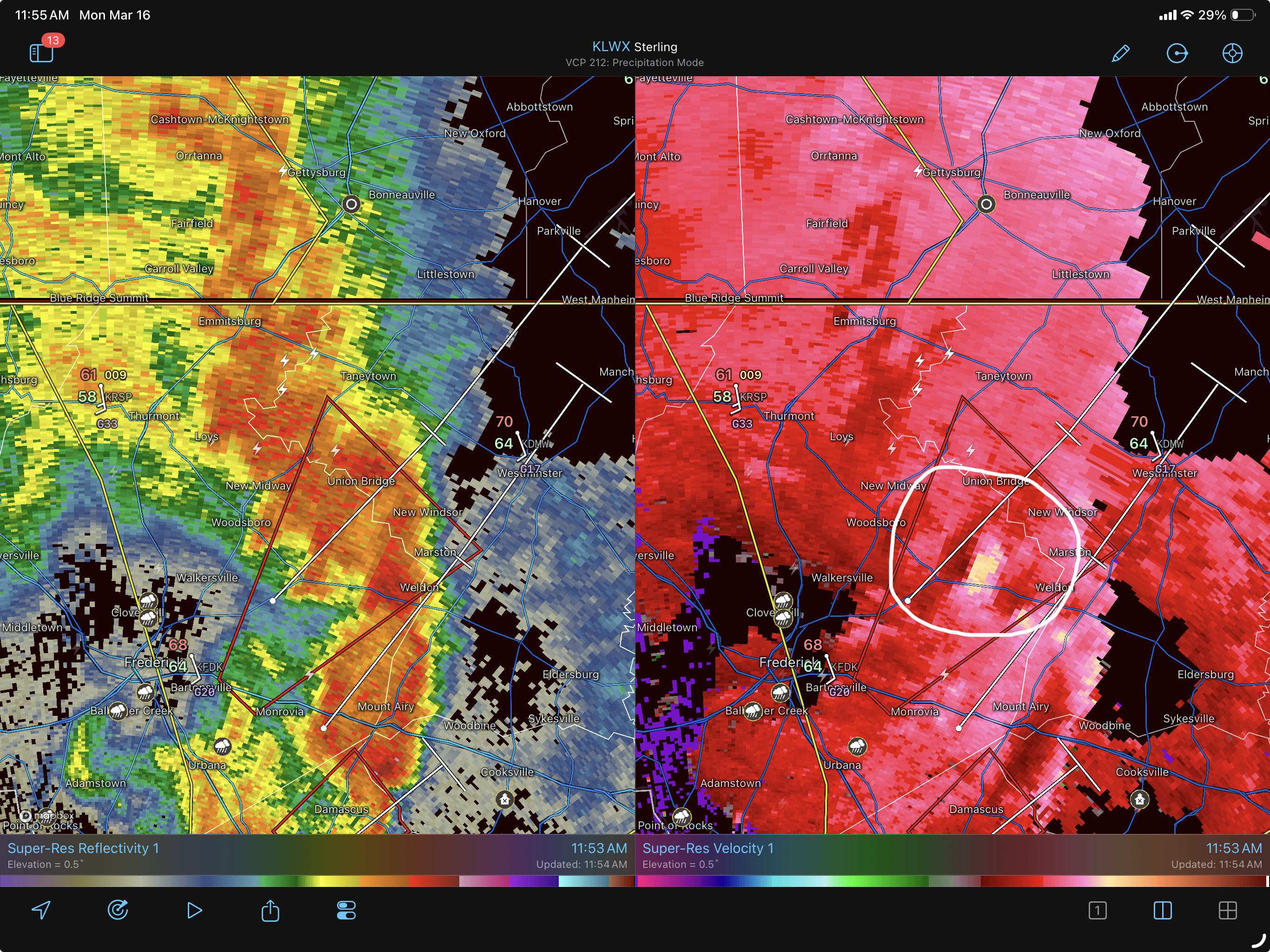
Pretty solid couplet in the newer tornado warning to the northeast of Frederick. The business end of this line with imbedded QLCS looks to be headed for York/Lancaster.

-
 1
1
-
-
Still trying to gauge the degree of which the severe potential gets realized tomorrow. High res guidance seems to be tightening the window when the best shear coincides with the surge of some modest CAPE into the Sus Valley, more in the late morning/early afternoon. HRRR looked like it was toying around with some discrete and/or quasi linear convection during that timeframe, while the 3k NAM doesn’t have much at all until the frontal passage. FROPA looked slated for roughly the 4-8pm timeframe west to east in C-PA. Discrete development out ahead depends on if there’s any kind of ample daytime heating via some breaks in the clouds, something I’m not quite sure happens in earnest in PA. Line with the FROPA will be more purely dynamics driven, but we’ll have to see how well it gets organized
Also lost in all the attention to the severe is energy rounding the base of the trough during tomorrow generating a secondary wave of heavier precip riding up behind the front. So suddenly it looks quite snowy in at least the western half of PA early to mid Mon evening. This could drive a changeover to a period of snow all the way into the Sus Valley. Given the broad model support I’d be surprised if CTP didn’t at least headline the Laurels and north central Alleghenies for advisories. There’s support for the I-99 corridor as well. That will also be interesting to watch evolve tomorrow in addition to the severe threat.
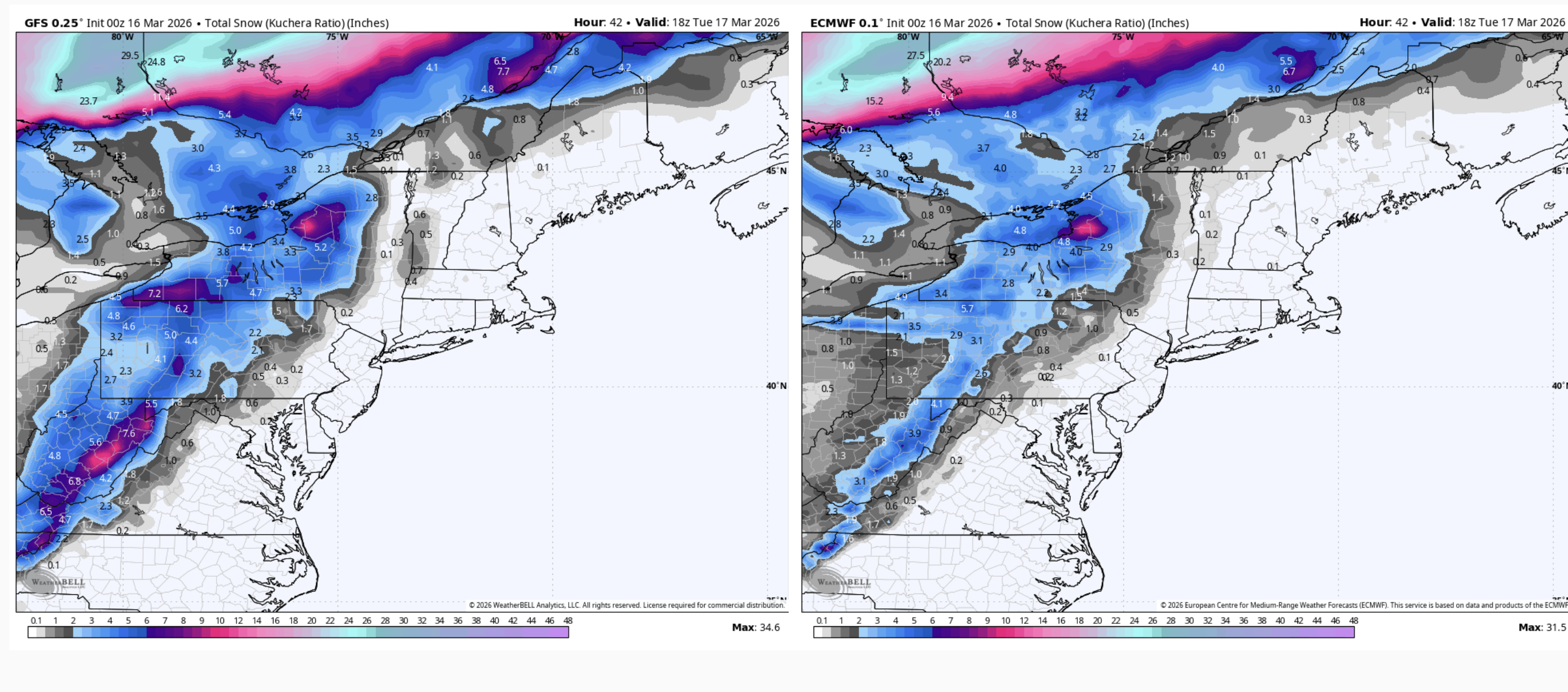
GFS vs Euro

3k NAM vs RGEM
-
3
-
 1
1
-
-
7 hours ago, canderson said:
Thanks for this. Remarkable this occurred up here back then. Today? Much more likely with climate changes.
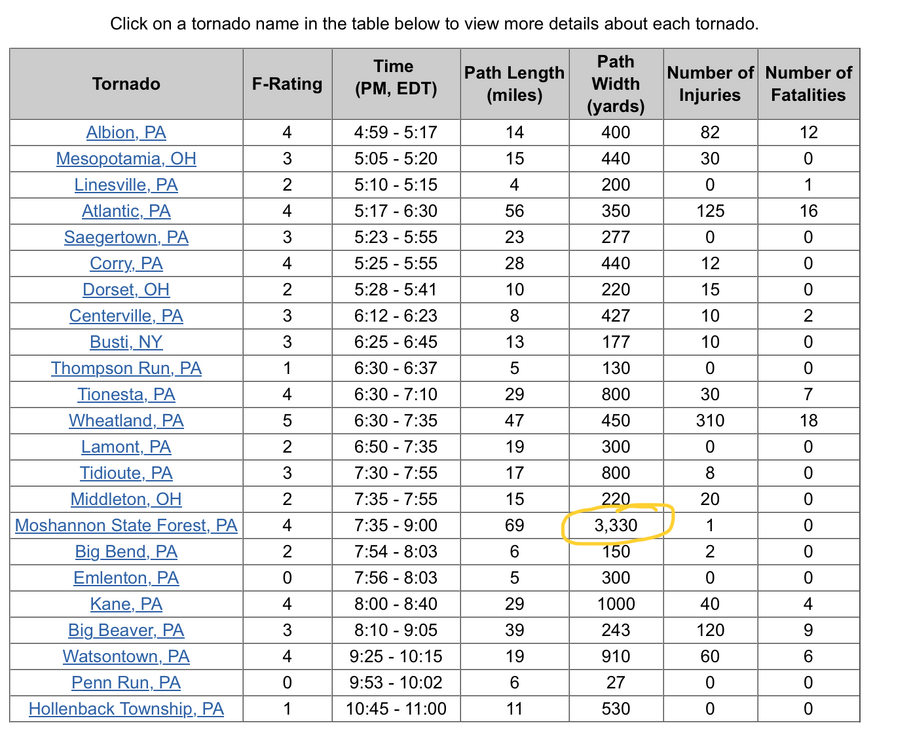
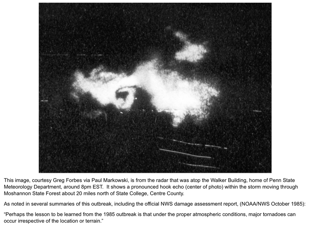
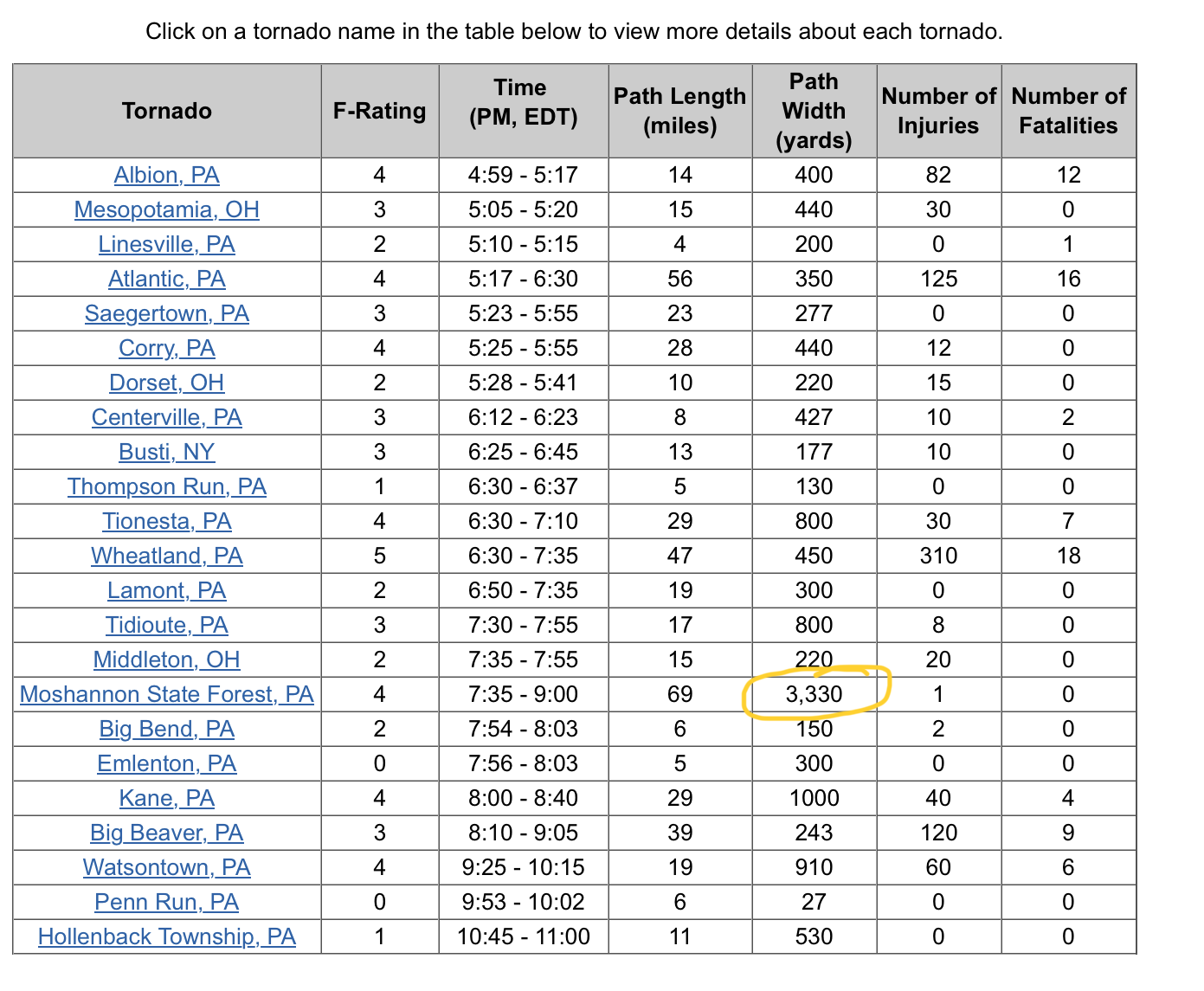
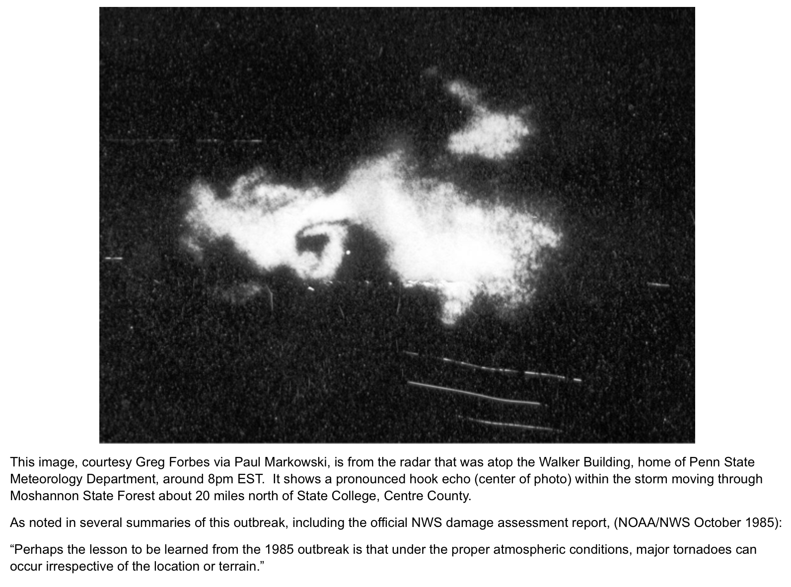
The May 31st, 1985 tornado outbreak was more severe and remarkable than 1998 or any other more recent PA involved outbreak by a pretty sizeable margin. That outbreak spun up 43 tornadoes and killed 89 people (1000 injured) in PA, NY, OH and Ontario (65 alone in PA), produced PA’s only ever EF5 tornado (Wheatland), and also produced what I’m pretty sure was one of the widest tornadoes ever recorded in the US at the time (Moshannon State Forest).
Couple screen grabs below but there’s some really informative links about this outbreak
CTP’s 35th anniversary link- https://www.weather.gov/ctp/TornadoOutbreak_may311985
New interactive link they made for the 40th anniversary last year collaborated with NWS Pittsburgh, State College, Buffalo, and Cleveland https://storymaps.arcgis.com/stories/e8c12f670d5648a9b64877f42660eeeb
-
3
-
-
3 hours ago, Itstrainingtime said:
A severe weather expert met in the MA sub (high risk) still has a few reservations about the extent and level of severe tomorrow. I hope his concerns play out.
Count me in on this thinking as well, in PA at least. Certainly dynamics look very favorable in terms of shear/helicity, along with very high low level winds to tap down. Whether or not south-central/Sus Valley cracks all the way into the warm sector ahead of the front to take fuller advantage of those dynamics seems to be a main potential limiting factor. 18z 3k NAM never really builds much CAPE in the Sus Valley (cloud cover), having a narrow corridor of modest CAPE further west in the south-central counties. Newest high res model runs doesn’t look particularly organized with any kind of solid QLCS line, which would be the primary threat here over discrete cells… though I wouldn’t rule those out completely, esp with any breaks to help with daytime heating.
As a side note the 18z 3k NAM was a prolific snow maker behind the front in western/central PA and other high res like the HRRR has at least a couple inches mainly in the Laurels/north-central.
As another side note, this is occurring tomorrow literally one year to the date last year that we had a QLCS type line come through mainly the western and central part of the state with many tornado warnings and an 89mph wind gust at Latrobe.
-
2
-
1
-
-
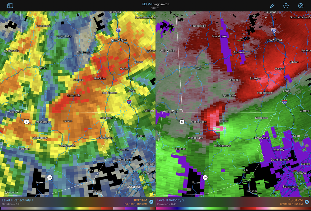
2 hours ago, Summit Snow said:
https://www.tornadotalk.com/may-31-1998-pa-ny-tornado-outbreak/
For those new to PA I remember this like yesterday. Those three days were off the charts in terms of storm potential. I was Tornado warned twice on 6/2 with the second warning being the Lake Carey tornado that killed two and injured dozens.
I was just playing around with the archived radar data that’s on RadarScope Pro the other day. Here’s that tornado, that’s a pretty pronounced velocity couplet for 1998 NEXRAD data. It was roughly reading 110-115mph gate to gate on the data.
-
1
-
-
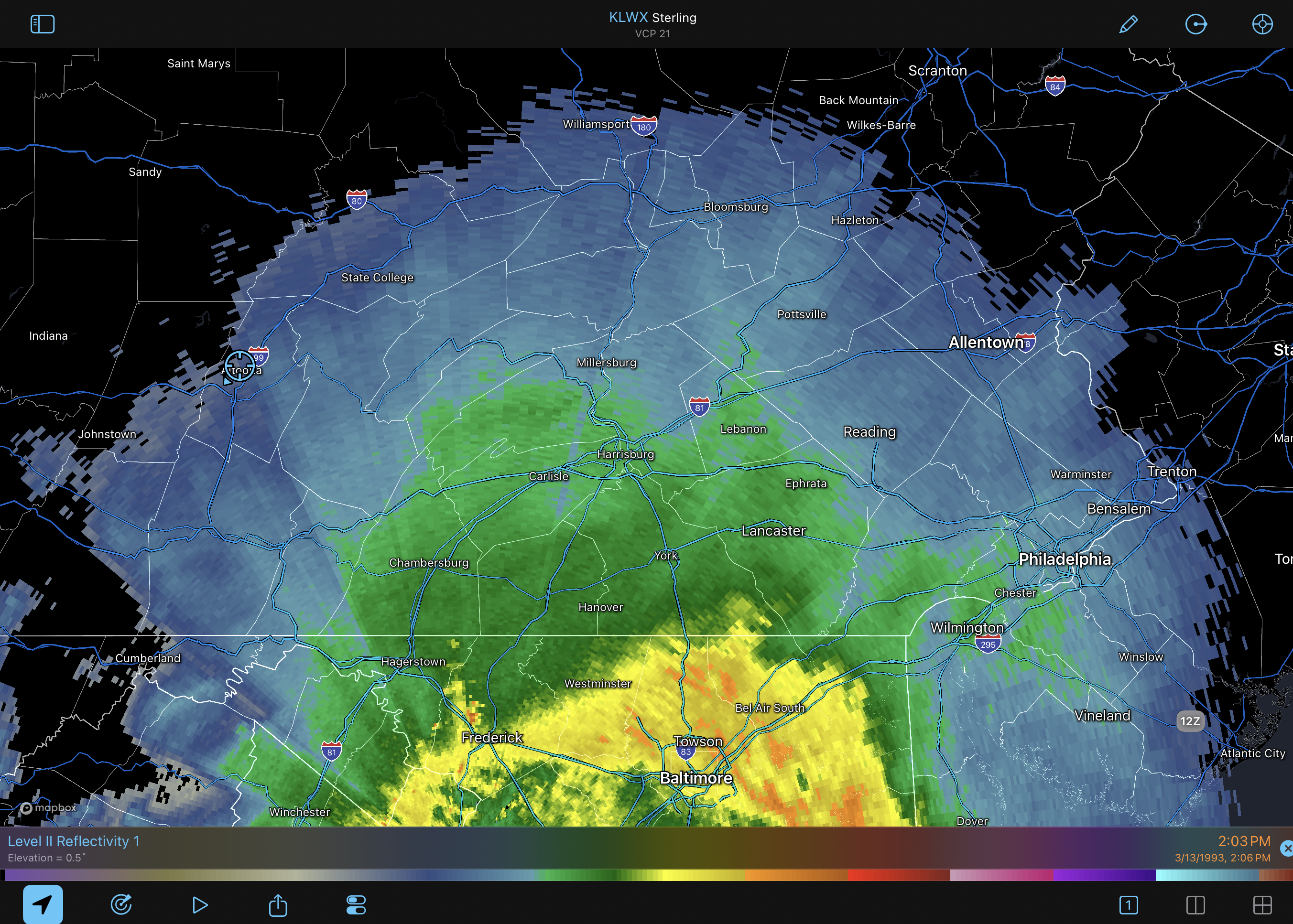
I think you had an upload error
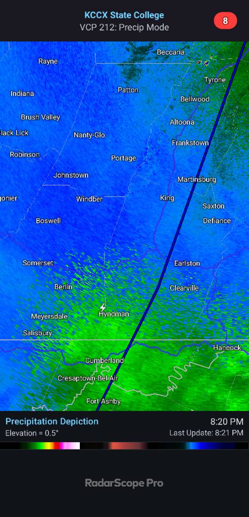
Yea sorry about that haha, I was exploring how far back the archived radar data went, that’s from 3/13/93.
. -
Here’s an archived radar image I could get on board with. Some other March 13th a while back.

-
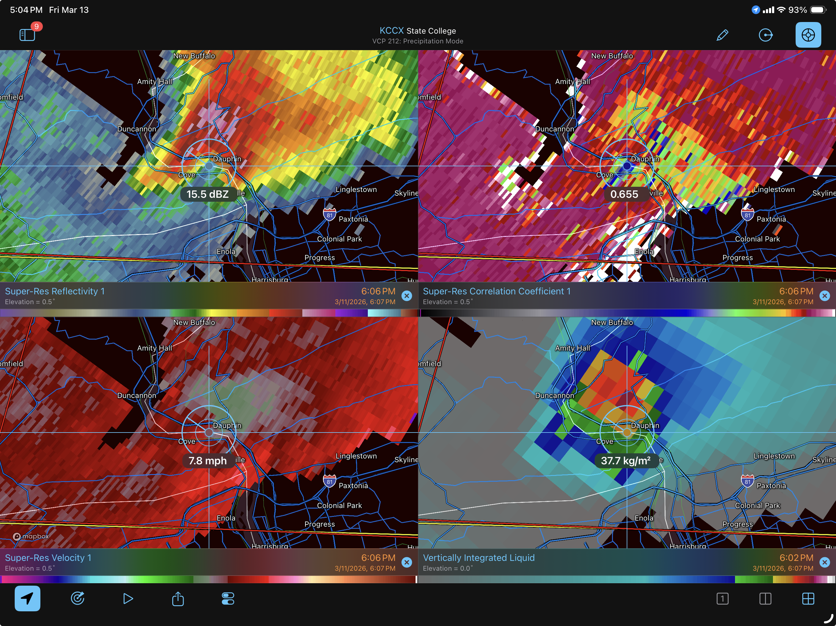
10 hours ago, mahantango#1 said:
Found this on facebook I didn't know NWS was doing a storm survey.
Dauphin County Tornado UpdateSome followup on the tornado warned storm in Dauphin County on Wednesday. I have actually drive on the exact road in the exact rural area it struck and there's a solid chance it missed every home as it's extremely rural in Shermans Dale and Blain, PA.The storm would have only been on the ground for a short time maybe 10-15 mins, 3-8 miles max before lifting. This may have hit a house or just tore up some woods but there was clearly evidence to suggest it was causing damage.I clipped a photo of the debris ball with the overlay of the general area it would have been. It's all thick woods and very rural homes. I personally stayed in a cabin about 2-4 miles from the exact spot this storm happened at. I'm very curious to see what the NWS survey team determines when they conclude their investigation.Anyway, thought this may be interesting to everyone. I'll update when I found out.- Espresso


When I ponied up and upgraded my RadarScope to the Pro subscription this winter I forgot one of the features was archived radar data. So this is a really good example to try it out and review something. Basically, I’m not doubting the chances that this storm might have spun something weak up somewhere along the way but I think this posted screengrab of the CC labeled as a debris ball to prove a tornado on the ground is a bit of a stretch.
So here’s the 606pm image that was shared, crosshairs placed on the “debris ball”
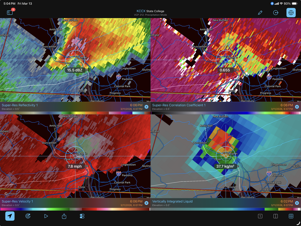
One thing about debris ball signatures is the area of low CC values are usually co-located to an area of high DBZ reflectivity values, which this CC signature is not. They’re also typically associated with established, strong tornadoes (>EF2), which I’m not really seeing the support for on velocity data, or obs/local storm reports. Even though this passed thru a relatively sparse area, it did still cross US 22/322 during this period. There weren’t very many reports on this storm at all looking over the LSR’s.
This signature likely had more to do with the hail core that this cell did have with it, which will reduce the CC values and can also cause a corridor of reduced values in the downstream direction of the radar beam when there’s a pretty decent hail core.. which can be seen on the images.
-
3
-
-
9 hours ago, Itstrainingtime said:
Pictures being posted in the MA thread are something else - a lot of white landscapes in areas that were around 70 degrees at 6am this morning.
That’s just crazy how that all evolved down there this morning. The DCA ob was even registering a heat index last night when I had posted about it.
People in there rating/upgrading their winters to A’s and such haha. If I don’t get any more snow this season beyond like a 1-2” bush bender I’m rating my winter a C-, and it’ll take a late March/early April 2018 type run for me to rate it any better than a C+. The only reason I won’t rate it worse than a C is the consistent cold + scoring the big storm on 1/25. But temps were similarly cold consistently last winter too, just without the big storm. My snow total is sitting basically on par with the last 4 winters, which were all solidly below normal for here. So I’m grading tough.
-
1
-
-
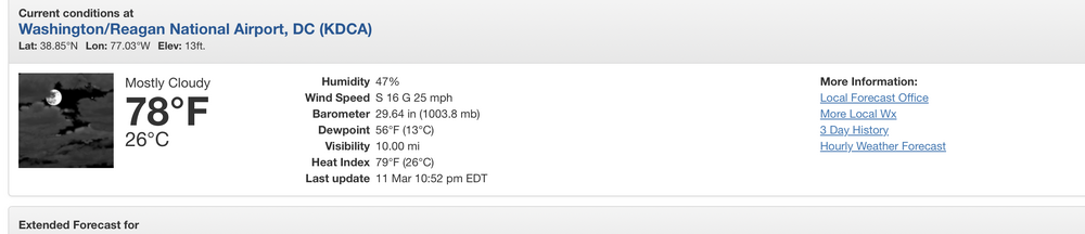
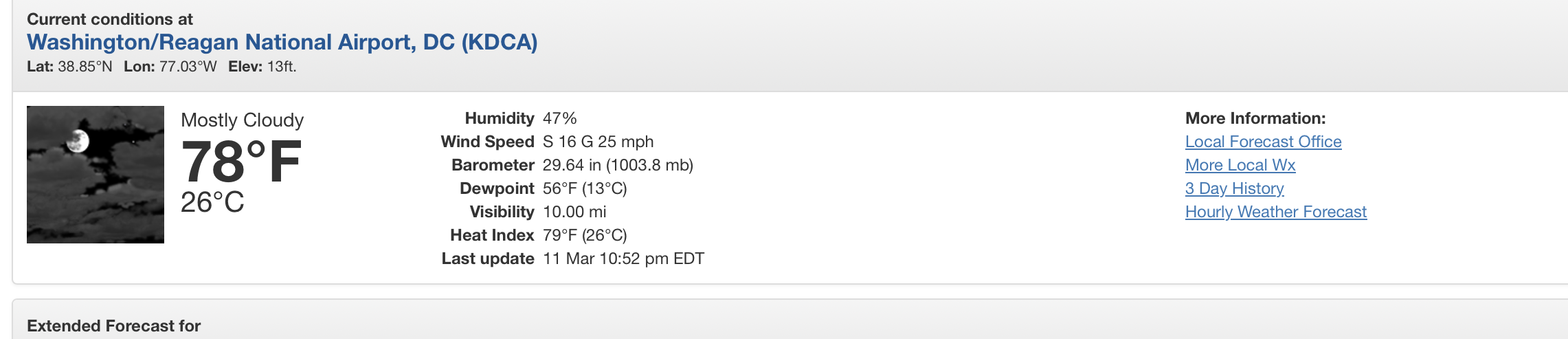
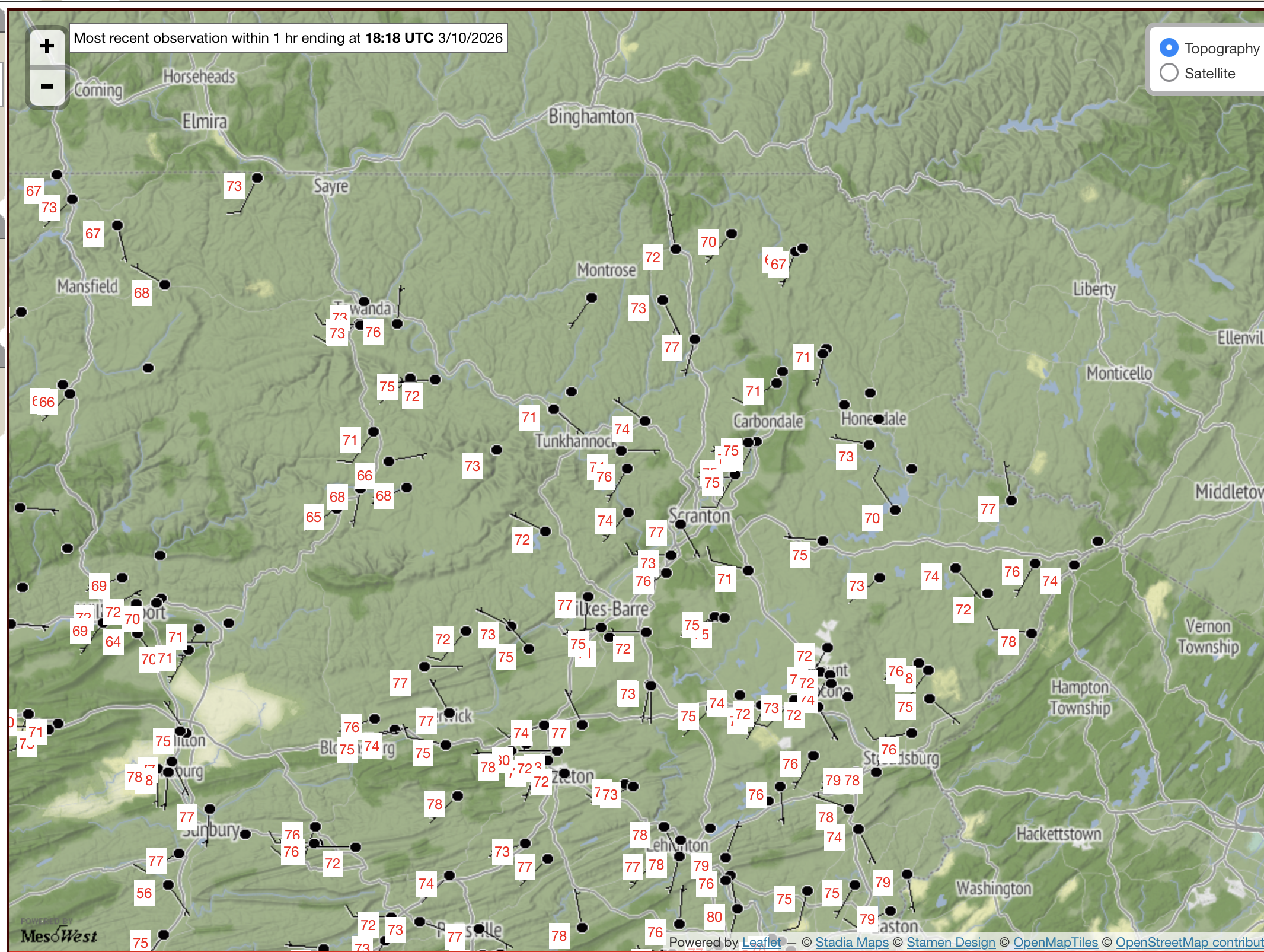
I know this isn’t our area but it’s going on midnight and it’s still nearly 80ºF in and around DC, on March 11th. That’s nuts
-
3
-
-
On 3/4/2026 at 1:50 PM, WmsptWx said:


Here’s the follow up on all this haha

-
2
-
-
Busted back out of the overcast/drizzle this afternoon and well into the 60s again today (as high ans 65ºF) after it had moved back in after dark last night.
The severe setup definitely escalated quickly in western PA, with temps reaching near 80 with dewpoints near 60. Decent shear/wind parameters and at least some CAPE (500-1000) along with some discrete cell formation. That will definitely need monitored over there. Obviously will remain much more stable in eastern PA at the low levels with the overcast and cool air damming but might still be some rumbles of thunder with anything that makes it over that way tonight. I do expect non-diurnal warming this evening in the spots that have been most locked in to the CAD as the approaching system/ SW flow will eventually mix some of the warmth down.


Central PA Spring 2026 Discussion/Obs Thread
in Upstate New York/Pennsylvania
Posted
I know I pretty much said near the beginning of the month I was at a C- if nothing else happened and no better than a C+ unless it was a 2018 type ending. Since the 3/15 event delivered 2.5” and thundersnow plus an extra half inch or so of squalls the following day I’ll take the minus away and make it a plain C grade.
I just can’t grade it any better than that here despite it being consistently cold. The 3” this month puts me at 31.7” which is still roughly like 10-15” off of getting into what would be considered average at my location. The rest of this month has been decidedly more Morch than March with multiple 70+ days and an 84ºF on 3/22. I went nearly a month between measurable snows from the main headliner 1/25 storm to the 2/22 event that was a big bust here and a main headliner for other folks. Didn’t do well with northern branch stuff (Clipper type systems) this winter either as a lot of them tracked the low north of PA, continuing that trend. Completely different story on the non downslope side of the mountains. Pittsburgh is at about 52” for the season, nearly 10” above average for them.
And to make this post sound less like a 1 star review I will say this winter did do well in timing its best deep winter period right with mid-late Jan climo and being overall cold from December thru most of Feb.