

MAG5035
-
Posts
6,078 -
Joined
-
Last visited
Content Type
Profiles
Blogs
Forums
American Weather
Media Demo
Store
Gallery
Posts posted by MAG5035
-
-
0.65” of rain here yesterday.
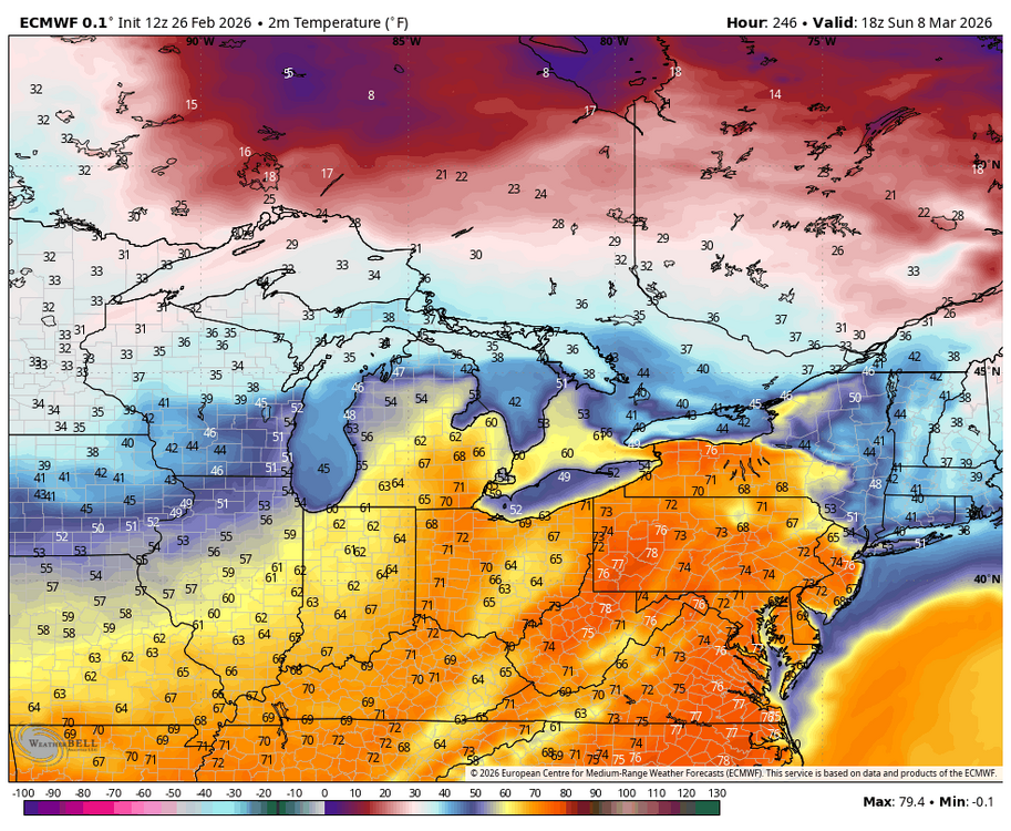
Eastern PA definitely looks to be denied a full torch this weekend as cool air damming, cloud cover and maritime flow off the Atlantic have a firm hold east of the mountains. Meanwhile from the Laurels westward, increasing breezy southwest flow is going to make for much warmer temps, likely making a run at 65-70 or so on Saturday. Sus Valley may eventually mix down 50s to near 60 later Saturday/Sat night as a weak frontal passage approaches.
Mon-Wed is the real time frame where it looks quite warm, as it has looked consistently on models for like the last week. Tuesday is the best chance for at least the southern half of PA to make a run at 70ºF ahead of the next system. Some difference between Euro and GFS with the Euro being much more expansive in PA with the very warm temps and GFS more confined to southern PA.
Much more uncertainty abound beyond that, big differences between the Euro and GFS. Euro has been way colder around the St Patty’s day timeframe and also has a storm on tonight’s 0z run. GFS bottles up cold air more in Canada and runs a further north storm track. Both models and ensembles develop the really negative WPO, which should put a lot more cold back in Canada. They’re also pretty firm on a pretty positive AO and NAO though, which would suggest cold intrusions into the US are limited and brief. Difference area is the PNA, where the Euro/ensembles (and Canadian) reverses a pretty negative PNA to positive to set up western ridging and a chance at the kind of storm it puts out at 0z tonight and holding a cold pattern more. The GFS op just keeps the PNA solidly negative and its ensembles do reflect the other models more with the reversal but is more neutral. I’m fairly pessimistic overall on any decent snow chances in that timeframe mainly due to the +NAO/AO, but building a western ridge even briefly would at least allow for a window to try to line something up.
-
 2
2
-
-
Freezing rain has arrived here and quickly glazing. 29/27ºF
-
BGM’s take, since they have been updating CTP’s AFD since yesterday morning.
QuoteArea Forecast Discussion National Weather Service State College PA Issued by National Weather Service Binghamton NY 210 PM EST Thu Feb 26 2026
KEY MESSAGE 2: The long wave trough remains mostly in place across the region Sunday night into Monday night, but uncertainty arrives with the wave pattern to the south that may bring additional rounds of precipitation to the region. A couple waves move in from the central US and attempt to brush the southern fringes of the cold air mass during this time with some potential episodes of rain/snow, but there is still quite a bit of uncertainty regarding the north- south extent of these waves. There is high confidence in the overall pattern becoming warmer by the middle to latter part of next week. Several short waves may move across the region during this time as well, which would likely bring rain (rather than snow) to the region. Will need to monitor this potentially significant pattern shift as this could prove impactful to the break up of river ice and lead to an increased threat of ice jams.-
2
-
-
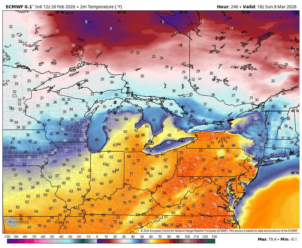
This one’s for you @Voyagerhaha. Once we route out the lingering cold later next week after whatever happens Monday, guidance shifts high pressure to a Bermuda high positioning and that would likely usher in the warmest air we’ve seen since about October. Euro/GFS both have multiple days in the 70s late next week into next weekend. Given setup and teleconnections (+AO/NAO, +EPO, -PNA) I don’t think this one get’s muted.
-
 3
3
-
-
35 minutes ago, Blizzard of 93 said:
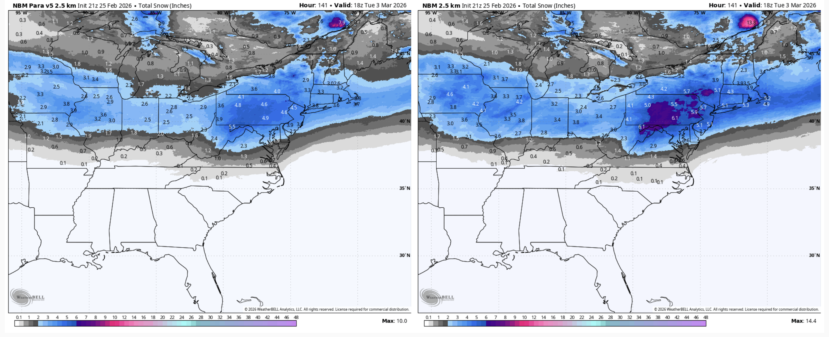
The latest 3 Major ensembles each get solid Advisory level snow to all of CTP by Tuesday afternoon.
The main takeaway is that we are certainly in the game for an event chance early next week.
The NBM looks quite good with it as well at the moment.

Hopefully we don’t lose it like the system that originally looked like it was going to impact tomorrow or this thing edges north more and we end up with a messier outcome
I do believe this potential event might be the last good shot at something decent for awhile as the signals for a more persistent and significant warm up in the East beginning later next week are looking pretty strong.
-
2
-
-
4 hours ago, Jns2183 said:
1919 103"
1924 74
1925 70
1926 90.75
1927 67
1928 81.75
I believe those were the snowfall readings from a place called horseshoe crab in Altoona. They want very many stations back in the day. And Altoona area as a super wide variance it's snowfalls depending upon location with elevation and lake enhancement. Trying to get a handle on that area's actual snowfall through the years was a nightmare because of that. So much of that years mean was dependent upon what station was reporting in where the stations were.
Sent from my SM-S731U using Tapatalk
Probably the Horseshoe Curve, which would make sense given such high seasonal totals and also being that timeframe was Altoona’s Pennsylvania RR heyday where a lot of that kind of reporting was likely done along the mainline. That’s close to halfway up the Allegheny Front (leading ridge of the Laurels) between the city itself and the top at Gallitzin/Cresson.
It’s hard to find much reliable data for the city itself. KAOO is more than 15 miles and one ridgeline over SE of the city. The airport doesn’t get as much snow, esp in upslope/LES and clipper situations being just that much further away from the Laurels with downsloping. Then of course, the really high variance from the city to the top of the Laurels in just a 5-10 mile drive.
I consider roughly 40-50” an average season here, using the much more reliable snow data up in State College as a general baseline (45.9 since 1893 and 43.8 on the 1991-2020 avg). It’s not perfect but I am averaging 35.7” since the 17-18 winter with some pretty lousy winters the last 4 years. On the other hand, what will be the new 30 year avg (2001-2030) is currently running around 38” a season for State College right now barring some big winters the next 4 years.
-
1
-
-
I had a light coating first thing this morning but that is long gone as well as some of other snow that is on the ground.
Despite getting the first double digit storm in 5 years and the prolonged cold and pack, I’d probably rate my winter a C if not much else happened next month. The only other snowfall that even got to the 3” mark this winter here was all the way back on Dec 2nd.
-
1
-
 1
1
-
-
42 minutes ago, Yardstickgozinya said:
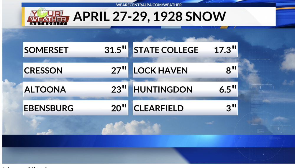
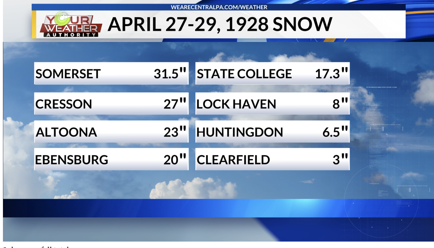
I was just looking up some data on late season events and I found this one that I don't believe i've heard talked about here. Obviously it's an anomaly and i'm not using it to prove any points here, but nevertheless, who would have thought you could have piled 21" of snow in Harrisburg, only a few days away from May.
The April 27-28, 1928, blizzard was a record-shattering late-season storm that dumped up to 21 inches of snow on Harrisburg, PA, and over 35 inches in surrounding mountainous regions. It paralyzed central Pennsylvania, closing businesses, causing widespread power outages, and breaking trees due to the weight of the snow on foliage.Key Facts About the 1928 Event:- Impact on Harrisburg: The city was "buried" under a 21-inch snowfall, described by The Patriot as one of the worst storms in history, bringing life to a complete standstill.
- Regional Impact: The storm hit the Mid-Atlantic and Appalachian regions, with Pennsylvania being hardest hit, though mountainous West Virginia saw up to 40 inches.
- Transportation Chaos: The storm stalled travel, including stranding the "Red Arrow" train for three days near Paoli, PA, with passengers forced to burn seat cushions for heat.
- Meteorological Significance: The storm was a "bomb cyclone" (rapidly dropping pressure) that hit in late April, making it one of the most devastating, late-season, and rare snow events of the 20th century
I’ve mentioned it somewhere in one of these threads in the past. I don’t believe that event dumped anywhere near that much snow in Harrisburg though. The NOAA NOWdata at Harrisburg/Middletown for those two days has over 3” of precip but only 2.4” of snow.
It did dump those kinds of amounts back this way and on down the Apps thru WV and KY though. The local station here had something on it a few years ago.
https://www.wtaj.com/weather/the-late-april-snowstorm-of-1928/
-
1
-
4 hours ago, Jns2183 said:
Watching that band gave me flashbacks to 2016. I also think it's worth noting how that south Central pa was the jackpot in that historical storm. Even accounting for "climate loading"—the observed increase in high-intensity precipitation events due to a warmer, more moisture-rich atmosphere the return period for
30" 82 years
33" 145 years
36" 260 years
People here recorded those values during that storm with kmdt having 30.1"
That's a once in 3,6,10 generation type event and was only 10 years ago.
Sent from my SM-S731U using Tapatalk
That makes me wonder about the statistical anomaly of the stretch of winters from 92-96 (sans 94/95), which in additional to being 3 of State College’s top 5 snowiest winters (93/94 #1 with 109.3”) was the heyday of really big snowstorms back this way. 12/10/92, 93 Superstorm, and the 3/3/94 nor’easter were three events in basically two winters that delivered that kind of snow in this part of central PA.
-
2.9” was what ended up calling the snow total here, about 1.3” from approx midnight to 8am Sunday morning and then another 1.6” from mid Sunday evening thru mid morning today. Some upslope stuff trying to set up so maybe can sneak a little bit more.
This brings my season total to a fairly meh 28.7”, generally on par with the last 4 winters if winter ended today. Plenty of time obviously but it’s starting to get late.
Clipper tomorrow night will likely favor NW PA, Laurels and perhaps down I-80 over to the Poconos. Track of the low staying in the lakes doesn’t bode well for much making it into the Sus Valley (downsloping). Then we’ll see what we have to work with for Thursday’s wave. Today’s suite has GFS/Euro ops skirting most precip south, Canadian half decent, and NAM/RRFS more mix/rain confining snows to northern PA. GFS/Euro ensembles look a little more amped on average vs their ops. I think most of us should see precip from this wave, my main concern is p-type issues.
-
1
-
-
1 hour ago, canderson said:
The storm to our east - NJ/NYC/LI and up into SNE is historic. Record stuff.
Somebody in SE Mass is gonna end up with over 3 feet with that band sitting over them right now. Most reports around there are already nearly 2 feet.
-
3
-
-
29 minutes ago, Itstrainingtime said:
I think there's a good chance that I'd communicate a little bit better professionally.
")
Hey, I got lucky with my "forecast" but unfortunately, it's going to be my last one. And this is what I wanted to get off my chest last night -
When significant winter storms are threatening our area, there's a group here at work that collaborate on how to handle adjusting operations schedules. I'm a part of it for 2 reasons; one, I'm in HR, and two, I'm looked at as the company's "weather authority" to some extent. This storm will be my last for providing my insight. Why?
It's become a pain. I was approached last Wednesday for early thoughts on the storm. I shared the same thing here at work that I shared here online. I gave probabilities that were intentionally vague being 4 days out. Then on Friday morning, I gave my "call" of 3-6". I was ridiculed. I was harassed. I was dare I say it, even threatened. Because, I was bombarded with snow maps. Snow map after snow map after snow map of every model from every Tom, Dick, (intentional use of that name) and Harry showing 13", 16", 20", 25" that were literally pushed in my face and told that I needed to change my call. I explained my thought, my reasoning as to why I thought they were all off. I said that yes, there would be those amounts, and yes, they would be close to our area, BUT I felt pretty good that it was going to slip east over the final 24 hours. They didn't want to hear it. (even though they came to me for my thoughts)
I was hit up again on Saturday. Same thing, new day. Texts. Emails. More maps. Oh my, more maps. I'm not kidding, I was emailed and/or texted well over 70 snow maps on Friday and Saturday alone. I was asked once again about Sunday. I reiterated that Sunday during the day would be a non-issue. More flack. More hostility. Whatever. And you know what came next? Yesterday, I start getting texts. Emails. Calls. Why isn't it snowing? This is a bust. Is it even going to snow at all? I'm thinking "did you actually stop and listen to me at all?" And on and on it went.
Today, right now I'm sitting in my office at work. Alone. I am THE only one in the entire office building. Why? Despite the fact that every road was wet this morning, the decision was made to shut down. The decision was made on Friday. Here I am. Angry. Frustrated. Tired. And most of all, jaded. People today do not know how to act. They sure as hell don't listen. And it saddens me how people act. Hey, this storm was almost impossible to forecast...I mean really, like @pasnownut said...we were THAT close to something much bigger. And that's just it. If you forecast the weather today, you better have really thick skin because if you're wrong, your ass is grass. The amount of hatred and mocking online yesterday towards WGAL's storm team was sickening. This was probably one of the hardest events to predict ever. I had my reasons for my call but as I said...I still lucked out. At least mostly.
One big problem today is snow maps. Everyone has access to them. I had someone hand me a print out of the GFS 12z on Friday afternoon. I asked her where she got it and she said she googled how to access snow maps online. And these people see these maps and it's assumed that they're accurate. And then I have to explain why I don't think they are. Whatever. Snow maps have their purpose and they're fun to look at but they ARE driving a wedge between the general public and people who forecast weather for a living. Damned if you do, damned if you don't. They can't win. MU's biggest weakness is conveying those truths in a professional way. He's arrogant to a fault. That's on him. But for the rest of the met world...I sincerely feel sorry for all of you. The public has way too much access to way too much (false) information and it is putting them in an impossible situation.
I'm out. No more forecasts from me. Just not worth it.
I could be wrong but it sounds like everyone at work just wanted the extra day off, sound reasoning be darned. Which would make that really unfair for you to take that kind of flak. You certainly made a better forecast call than I did there.
The other part of your post is a really good example of why I personally don’t do the YouTube/F-Book/Twitter Met stuff. I’d much rather discuss in a place like this forum where enough of the regulars (certainly not all haha) for the most part understand the difficulty in nailing this stuff down. Don’t ever be discouraged making your forecast calls in here.
-
7
-
1
-
-
31 minutes ago, WmsptWx said:
Like that asshole deserves the attaboy.
Speaking of egos, I wonder how DT’s doing today haha.
On 2/19/2026 at 2:29 PM, mahantango#1 said:From our good friend DT:
NEXT TIME SOME IDIOT ARGUES THE GFS HANDLES EAST COAST SNOWSTORMS WELL...
TIME TO CANCEL THE GFS.....
33 INCHES OF SNOW DC ? Yeah its broken
every Single run of the operational GFS for the past 3 days has showed a massive historic record shattering blizzard for some portion of the Middle Atlantic...
now even the GFS AI is saying "WTF op-GFS !? "
The 6z and 12z GFS ensembles are waaaaaay east
The problem is that the operational GFS goes Bonkers with the 500mb LOW. It is over developing the 500 LOW amplification and it grabs the surface LOW and pulls a NW to just east of Wallops Island on the lower Virginia Eastern shore. Then every run of op- GFS stalls the LOW for 24 hours producing this incredibly heavy snow area from a monster rapidly intensifying Coastal nor'easter.
This is nonsense.
There is a better chance of monkeys flying out of my ass on Sunday night or Monday morning then this solution as proposed by the operational GFS of a massive historic BLIZZARD of record shattering proportions in the Mid-Atlantic actually concurring
As I stated in the video there is an upstream kicker and all the other models see it except for the operational GFS.
When the GFS AI and GFS ensembles don't even support this kind of extreme solution then you know the operational GFS is just busted.
I figure it's about 12 hours before somebody starts blaming immigrants for fucking with the model.
I mean yea DC wasn’t the epicenter, but let’s not forget where the Euro was with the coastal aspect of this thing as recently as like Friday.
-
1
-
-
20 minutes ago, Itstrainingtime said:
Lot of 5-6" reports from over there. I must have just caught some of that heavier stuff overnight. I was shocked when I went out early this morning. I easily had 4" on my car.
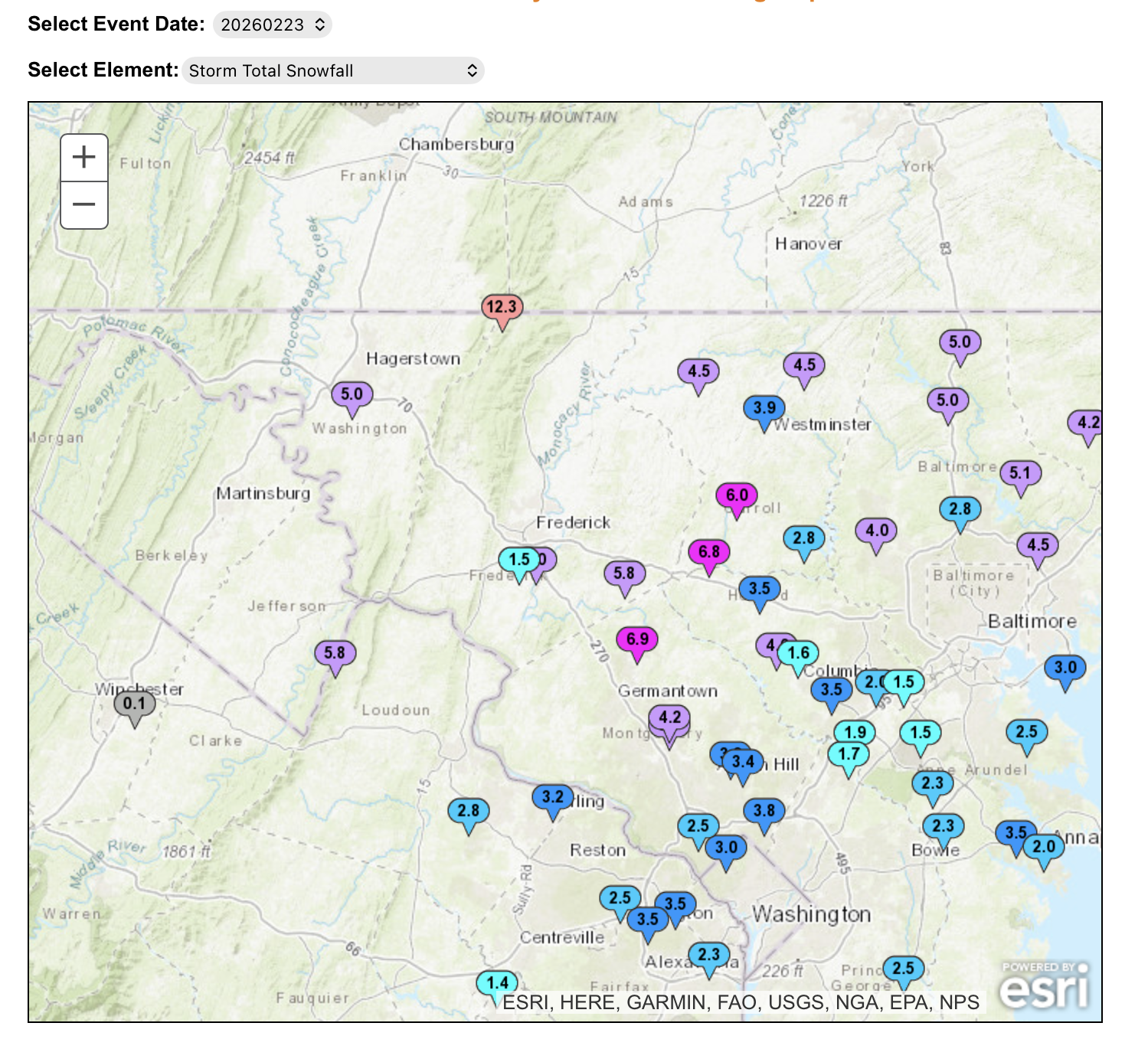
There was also a corridor of heavier snow reports along the Franklin/Adams border that translated to that same band that’s produced a couple 6”+ reports east of State College and continued down thru northern MD. That 12.3” is a Cocorahs report.

-
3
-
-
29ºF and snowing decently at the moment with the band that just dropped in from the north. This stuff looks like it has some enhancement from Ontario with the due northerly fetch so maybe it’ll actually do something this morning. For now 1.2” fell overnight to bring storm total to 2.5”. Been pretty breezy with a high gust overnight of 35.6 mph on the station.
Gonna have a look at totals vs the map I put out when this thing completely wraps up. Did not expect the York/Lancaster realm to do as bad as it did. I knew it was boom or bust potential there but I expected at least warning criteria to be met there fairly easily. The temps were an absolute killer yesterday with the lighter precip phase of the storm. IVT set up further east as noted and I think the storm really exploded just a hair late.
It is living up to its billing in NJ/NYC/LI and beyond. There’s already scattered 20”+ reports in NJ and LI, as well as a 71mph gust on the tip of LI. Official obs in Central Park, La Guardia, and JFK all reported 15” or so around 7am with a good bit of snow to go.
-
5
-
-
It’s been a much more powdery snow with this 2nd wave that made it back here a few hours ago. The streets and stuff have caved with temps now back to 28ºF but the rates just aren’t doing it here. I only have about 0.7” new in all that time. Combined with the initial snow that came through overnight last night into first thing Sun morning that brings me right around 2” total for the storm so far.
-
27 minutes ago, canderson said:
It’s melting and barley even snowing but I’d guess .25” or so
Not gonna make it to 1” probably - big bust, but a very difficult system to forecast
This is one of those situations I wish there was a radar located somewhere in the middle of the Sus Valley to see the banding better, as there are clearly some haves and have nots when it comes to where there are more significant accumulating snow areas.
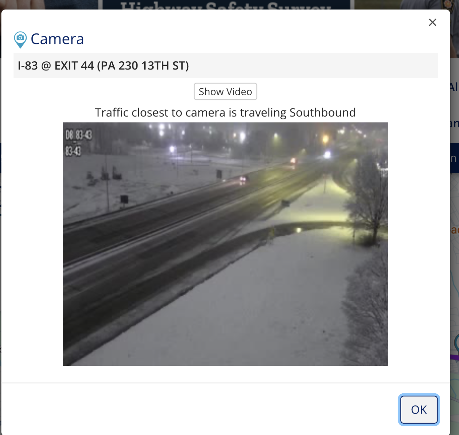
511 cameras in and around the Harrisburg area look half decent though, showing some of the primary roads caving.

-
2
-
-
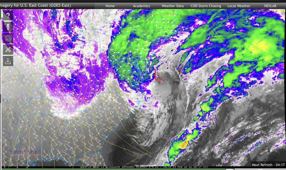
Nice placement of the comma head on central/eastern PA. So far the coastal low is still pretty close to the Delmarva coastline and hasn’t started to fade east yet.
-
3
-
-
Accumulating snow has finally resumed here for the first time in the last like 10-12 hours as that renewed surge of steady precip backing west has reached the I-99 corridor.
Winds are up too, with a high gust of 26mph (NNW). Temp down to 30ºF
-
2
-
-
Surface obs and radar line up pretty good showing the convergence zone for that inverted trough band.
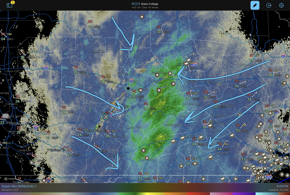
It has finally begun to snow again here, lightly. Temps are back below freezing as well back to 31ºF. At this point I’d consider another 1-2” from this event a win with that band setting up to the east of here.
-
2
-
-
I-81 from Shippensburg on south is starting to look snowy on the 511 cams.
Additionally US 322 goes from snow on the ground on the Lewistown side of the narrows to bare ground on the Mifflintown side.
-
4
-
-
21 minutes ago, Itstrainingtime said:
That was me multiple times. I was corrected by several here (correctly) that the storm isn't the same. However, I stand by my assertion that the pattern is. And that is what is behind these negative changes we're seeing.
Boxing Day 2010 didn’t have the inverted trough and had more of an actual sharp precip gradient from nothing to a bunch. This system has plenty of precip thrown back into central PA right now. Temps are the issue, I said a couple times the last few days temps and rates were going to be a key thing for I-81 corridor and NW. Unfortunately I didn’t expect surface temps to be warm enough to actually cause a lot of this stuff to be rain in the Sus Valley lower elevations today.. I was more worried about rates.
That puts more reliance to make it up on the direct banding from the coastal as it winds up and eventually turns things over as we get towards this evening. The big change there is the formerly aggressive guidance bringing the low in up close is now quickly jumping it ENE over or perhaps just SE of the benchmark. Which actually would be another difference from Boxing Day haha. That tracked straight up well inside the Benchmark to the edge of Cape Cod. The low kicking east faster is going to reduce the time the Sus Valley (esp York/Lancaster) can get any stronger bands from the coastal.
-
1
-
-
Current obs.
-
 4
4
-
-
Just now, WmsptWx said:
Puking snow currently
I think your in a good spot to be a winner for that inverted trough band.


Central PA Spring 2026 Discussion/Obs Thread
in Upstate New York/Pennsylvania
Posted
I busted out of the clouds here, was as high as 63ºF earlier. Still around 61ºF