

MAG5035
-
Posts
5,884 -
Joined
-
Last visited
Content Type
Profiles
Blogs
Forums
American Weather
Media Demo
Store
Gallery
Posts posted by MAG5035
-
-
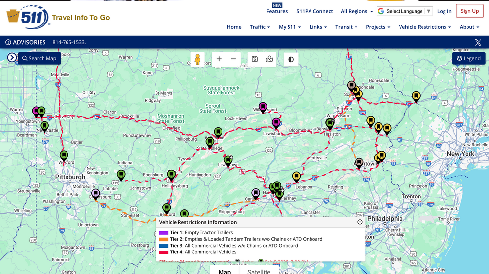
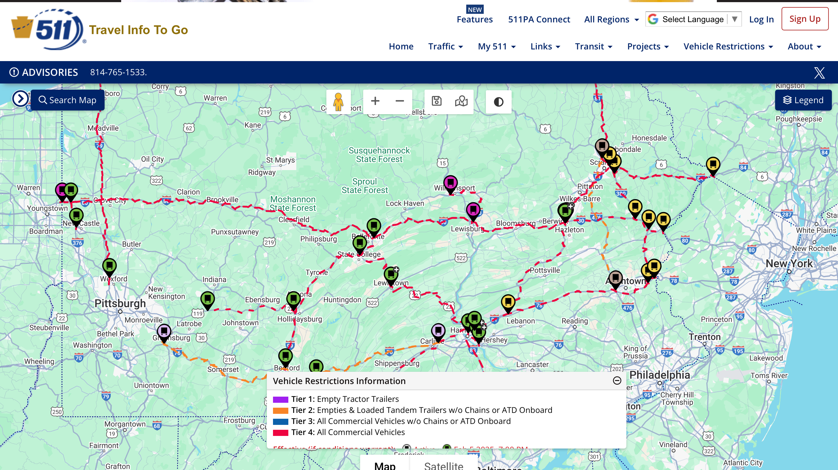
PennDOT not messing around when it comes to scheduled tier restrictions tomorrow night. Most major routes are tier 4, basically restricting everything except passenger cars/trucks and emergency vehicles.
-
 1
1
-
-
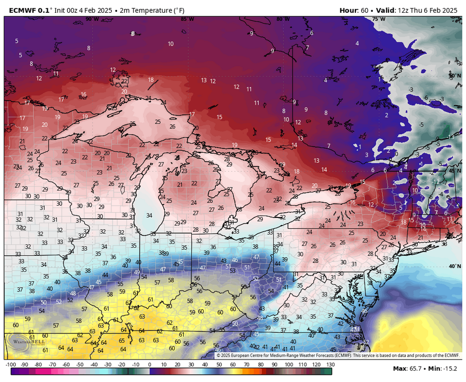
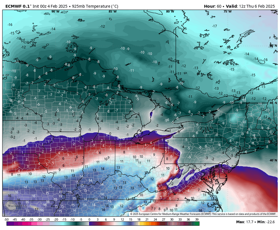
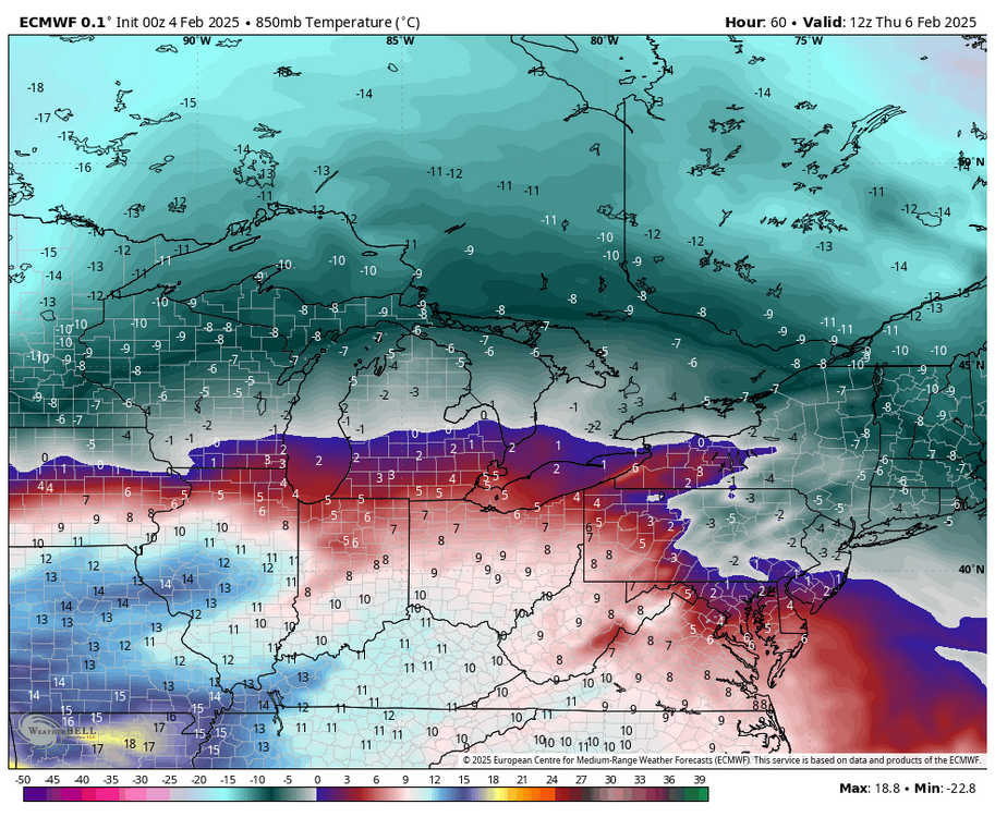
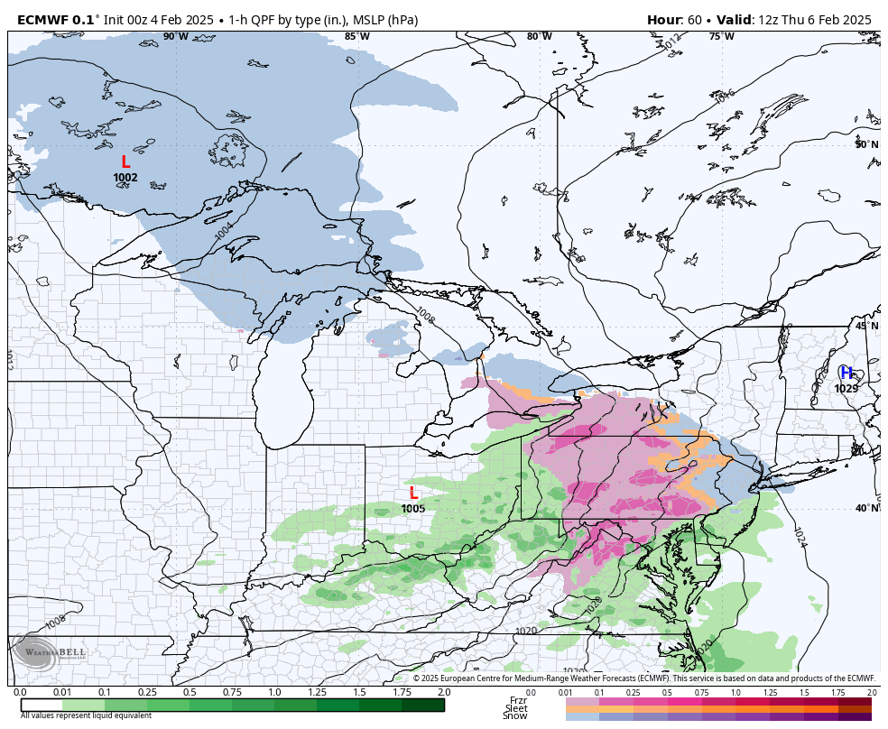
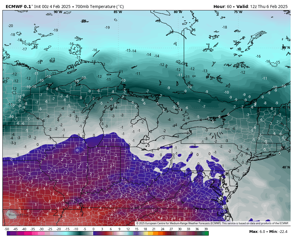
0z Euro continues to have a really large swath of mostly freezing rain with Wed/Thur’s event. Looking at thermals not really sure why it’s like that. Sleet may end up being the dominant p-type for many.
Using hour 60 at the 1 hr level here’s a breakdown up to 700mb at what it has at that point.
1 hr QPF/p-type

2m temps
925mb (3000 ft temps)
850mb (5000ft) temps
700mb (10k feet) temps

As you can see, well below zero ºC temps are well entrenched at 925mb level and the 850 temps are even solidly below zero in most of eastern PA. The warm intrusion goes quite high with this event, with the 700mb level near 0ºC. This really implies a solid period of pingers for most of us IMO. But the WAA intrusion will be top down as the event progresses, things will eventually change to freezing rain and then rain as the event ends. I think CTP’s watch placement is good for now, with perhaps them maybe adding a tier or two of counties east. What might happen with the Sus Valley is the business end of the heavier precip is sleet and a much shorter period of freezing rain before temps edge above freezing.
Wild card is what happens earlier in the day on Wednesday with the ribbon of WAA forced snows that some models are showing with varying results. The Euro didn’t have it at all. I suspect we’ll have something with that though maybe not as robust with the NAM.
Taking these threats one at a time. The weekend ice threat still looks similar to this one, though this one might end up with more actual QPF. For an actual snow event in C-PA I’m really liking what models have been showing around the 12th. I think we’ll be much better positioned for that period.
-
5
-
-
Daytime high was 53ºF here before falling back to the 40s early this eve. However, gusty winds ahead of the frontal passage have mixed down some really mild air. It’s 60ºF here right now, which is really overshooting short term guidance. Might not be quite as warm as here but I suspect you guys in the Sus Valley that have had some early radiational cooling tonight might see a similar spike in temps overnight.
-
Watches up in western CTP
QuoteURGENT - WINTER WEATHER MESSAGE National Weather Service State College PA 212 PM EST Mon Feb 3 2025 PAZ017-024-025-033-034-041500- /O.NEW.KCTP.WS.A.0005.250205T1800Z-250206T1700Z/ Clearfield-Cambria-Blair-Somerset-Bedford- Including the cities of DuBois, Altoona, Johnstown, Bedford, Somerset, and Clearfield 212 PM EST Mon Feb 3 2025 ...WINTER STORM WATCH IN EFFECT FROM WEDNESDAY AFTERNOON THROUGH THURSDAY MORNING... * WHAT...A period of snow or mixed precipitation possible Wednesday afternoon and evening, then significant ice accumulation possible Wednesday night into Thursday morning. Total snow and sleet accumulation of 1 to 2 inches then between two and three tenths of an inch of freezing rain possible. * WHERE...Bedford, Blair, Cambria, Clearfield, and Somerset Counties. * WHEN...From Wednesday afternoon through Thursday morning. * IMPACTS...Plan on slippery road conditions. The hazardous conditions could impact the Wednesday evening and Thursday morning commutes.
-
3
-
-
1 hour ago, Jns2183 said:
Do we get ice storm warning or just a winter advisory Thursday?
Sent from my SM-G970U1 using Tapatalk
Certainly the QPF involved in most of the models would imply a winter/ice storm warning in potentially a sizeable swath of central PA is on the table depending on the makeup of the p-types. Surface temps hold near or below freezing for most of the event in a lot of CTP, including even the LSV seeing several hours. Significant 850mb level WAA push early in the event would make any snow brief and set up for trying to figure out how the business end of the precip event plays out in terms of sleet vs ZR. Euro showing more of a straight freezing rain on it’s p-types but 925mb temps, which doesn’t get routed out as fast are quite cold and I would think reality would have a period of sleet involved more like what the 0z NAM/GFS/RGEM are implying.
Either way I’m seeing enough support right now to think winter storm watches may be needed in the 80 and south counties of C-PA, save for maybe Adam’s/York/Lancaster. The north central counties well north of I-80 need 0.5” or more for an ice storm warning and given varying precip types and potentially less QPF overall they probably wouldn’t verify that higher criteria. Biggest overall ice accumulation threat would reside in the eastern Laurels and the more immediately adjacent ridges off the Allegheny Front where the 925 temps would rout out quickest. Could be talking 0.5”+ of ice accrual there. I think overall it’s a pretty sizeable icing threat. CTP notes it in their disco and HWO. And it looks like we do a similar setup again for the weekend, so fortunately the temps warm up briefly in between events.
-
3
-
-
I think one thing that seems apparent out of the pattern look the next couple weeks is we are about to enter a period that has a good chance to at least start to reverse the ongoing dry pattern and make meaningful overall hydro impacts in the parts of PA that have been driest . Dating back to the fall we never really have had any significant systems or overly active periods and that appears to be what we are going to be getting into. Pretty confident on that.
What I’m hardly confident about is what p-type that much needed QPF reaches the ground as. Now tentatively I think this gets better (for snow) as we get to mid-month and beyond but I’m going to focus on the first two systems models seem solid on showing (2/5-6 and 2/9-10) first. I don’t think snow will be a major p-type with either here. GFS makes snow work with the 2/6 one because its split pieces where the first weak wave generates snowfall without rushing the column with big WAA at first. Euro and to a lesser extent the Canadian have this more in one piece and more significant low tracking across the lakes where the GFS has nothing but a better placed high and the wave squeezing underneath. There is still a retreating high so main wintry type would be freezing rain.
The following system (2/10) runs the boundary where in the 12z GFS case the low tracks to western PA and there’s a weak secondary attempt but it sets up for a significant longer duration mix/ice storm in C-PA. Euro low goes to the lakes but still enough cold for front end mixed/ice. Details about the low track,high placement, etc are well away from being resolved but I def think the icing threat is sizeable in at least some portion of C-PA (certainly interior and northern) with the combined impacts of both progged events. For significant snows I think this gradient pattern is going to favor upstate NY and interior New England.. perhaps southern New England. The 500mb pattern isn’t quite there for us IMO, despite plenty of cold air available… which is why an icing swath is going to be a notable threat.
500mb progs for week 1 are showing pretty sizeable + heights in the east, and a very positive NAO regime centered over Greenland. Persistent AK ridging keeps the cold pushing into Canada but this is going to focus west at first, especially with what looks like a persistent -PNA. Any stronger system is going to run too high for us to deliver good snows in that setup.
What changes in week 2, is that ensembles are starting to hone in on the AO/NAO reversing to negative as the Scandinavian Ridge progged over on that side starts to retro toward Greenland and link with the AK ridge. That would eventually press the cold (and the boundary) south into more of the US. If that look holds, we look pretty well set up for the second half of the month for better snow chances and eventually another significant cold outbreak. One issue I’m also watching is the MJO, as it is forecast to mostly be in 5-6 the next couple weeks but the magnitude of which varies on model. Either way I see more good things than bad in the pattern progs down the road right now.
-
6
-
-
0.45” on the day so far, the first measurable rainfall here in exactly a month.
-
4
-
-
Temps have ramped up to 42ºF here on a stiff SW breeze.
-
1
-
-
9 hours ago, canderson said:
What happens when the NWS and NOAA lose all funding in the next few weeks? We just rely on the Euro and Canadian and cross fingers?
I know this is “OT” but it is weather/forecasting related and I wasn’t in here this morning. I’ll keep it neutral although I definitely have my thoughts/opinions.
I can’t speak for anyone directly in the NWS/NOAA but regardless of what Congress eventually does allow to happen I wouldn’t want any part of the uncertainty I’m sure that agency and in general the large amount of federal service workers in all the other agencies are going through.
And meanwhile on the private sector/broadcasting side was the Allen Group attempting to replace over 100 tv Mets over three dozen local stations with prerecorded forecasts from The Weather Channel. I’m pretty sure someone in here had posted about that a couple weeks ago. They did retract on that last Friday after a good bit of public backlash. But it’s a direction these media conglomerates seem to want to go in.
-
2
-
-
42 minutes ago, Itstrainingtime said:
Generally agree. I’m not as enthused with how things evolved during the past week since I had my last pattern post. I did expect a potential warmer patttern after this week but I expected the first system to attack the lingering cold to be messy, which would be the current system slated for Friday. I think the ZR threat might be a bit understated on the models in the interior counties right now but obviously it’s a good bit warmer scenario than I was thinking last week.
My nitpick would be there’s a little bit more going on than just the +NAO/AO regime. PNA is solidly negative and also slated to remain such for the time being. A bit of a return to the last couple winters in that regard after being positive most of Dec and first part of Jan. That’s ultimately what actually forces heights up in the east. EPO slated to go from postive to solidly negative next week along with the WPO remaining negative. That keeps AK ridging and will allow for cold to push into the lower 48. That’ll all factor into how the gradient pattern establishes next week. Does cold stay focused in the west or will it press east at least some and press the boundary down? If MJO goes into the null phase that may not be as much of a factor. It still may end up running through some portion of 4-5-6 though. Daily SOI numbers have stayed quite positive most of the last two weeks. Lot of factors/uncertainty at play into what should be a much more active pattern storm wise.
-
4
-
 1
1
-
-
Quite the diurnal range here today, have made it up to 30ºF after starting the day at -1ºF.
-
2
-
-
2 hours ago, Bubbler86 said:
My take on both the GFS and EC op's, did not look at ensembles, is to get your break in this week and put your tracking pants back on next week. It could be a total zero in the end but we will have cold area near and eventually the SW pig is going to come out and open up the pipeline for potential bowling balls in a zonal pattern. Like Nut said, the WAR is not overly troubling on the LR progs right now.
Here’s the ensembles today, using 5 and 7 day averages so things will be smoothed out some.
GEFS v Euro 7 day average 500mb height anomalies (D8-15)

GEFS v Euro 5 day average temps (D10-15)

At first glance looking at the 500mb anomaly maps, it doesn’t look great… zonal for the most part but showing low heights over the top (+NAO/AO), troughing west of Hawaii, some SE ridging, etc. But the temp response is hardly indicative of a torch. I will note that the Euro ensemble has a more sizeable warmup D12-13 in the eastern US before going cold again. The GEFS never really does get the NE into any kind of above average temps.
The last couple winters a 500mb pattern like that would be a pretty pessimistic outlook but this winter isn’t the last couple winters. It’s simply a colder pattern on our side of the pole despite the less than ideal 500mb look. Look where the big + temp anomalies are. That was Canada and the northern US most of last winter. This winter I think we can score out of a zonal pattern, presuming we can get some actual decent systems to develop out of it. Even if we do get an above average regime eventually I don’t really expect it to just warm up and rain. The first decent system to actually attack this persistent cold pattern is likely to be messy.
-
6
-
-
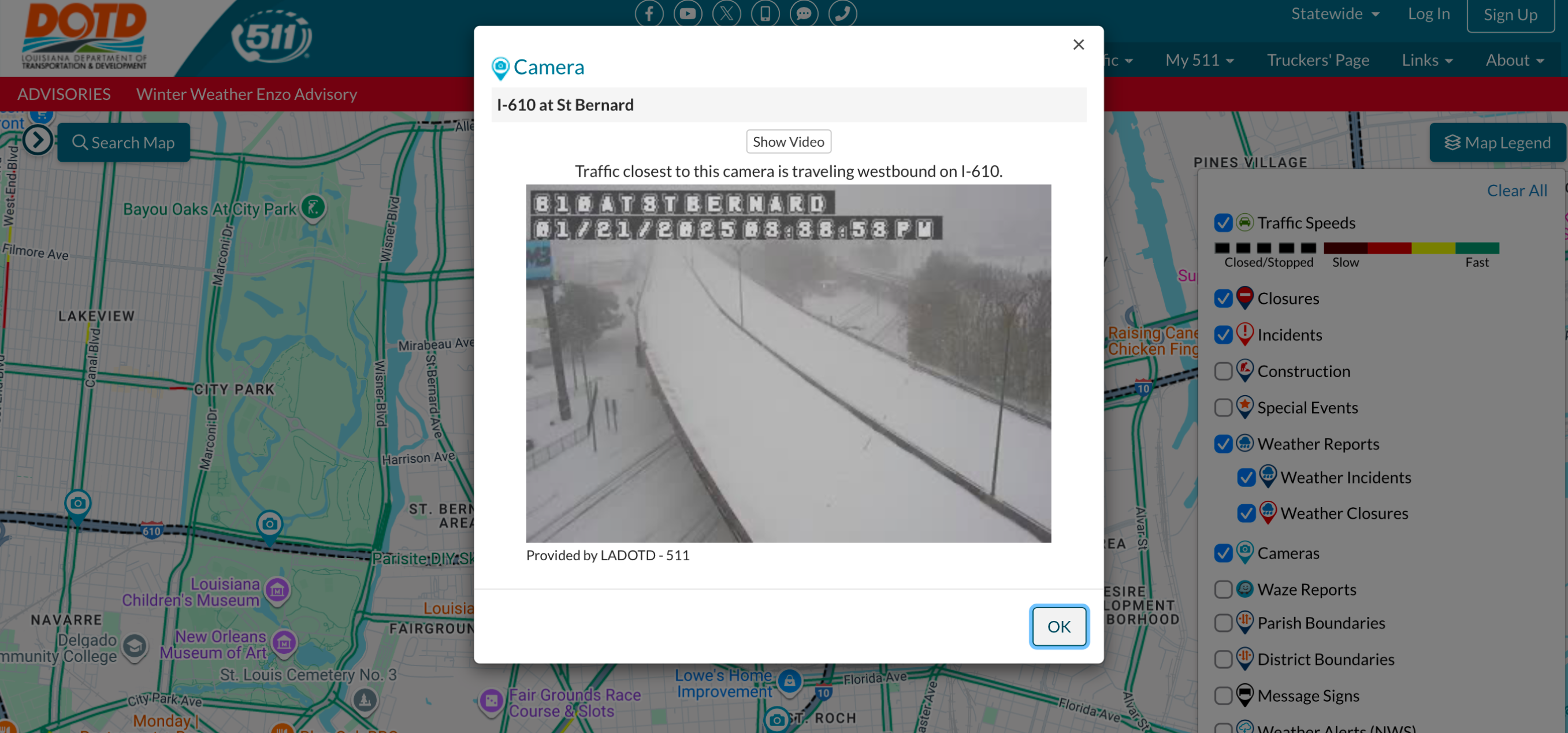
Meanwhile deep in Louisiana bayou country…
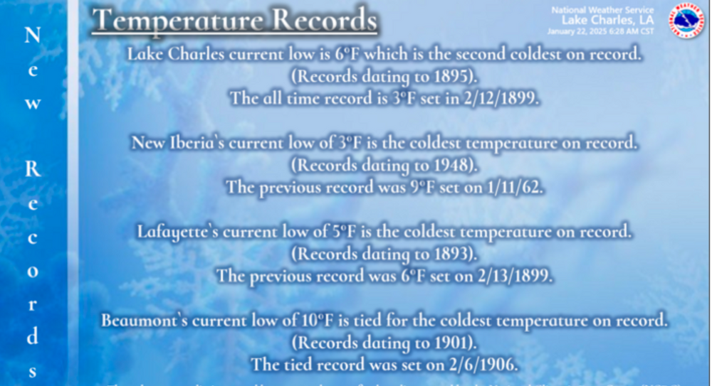
I also saw some temps as low as 10 in the Florida Panhandle and 15 all the way down in Gulf Shores, AL
-
5
-
-
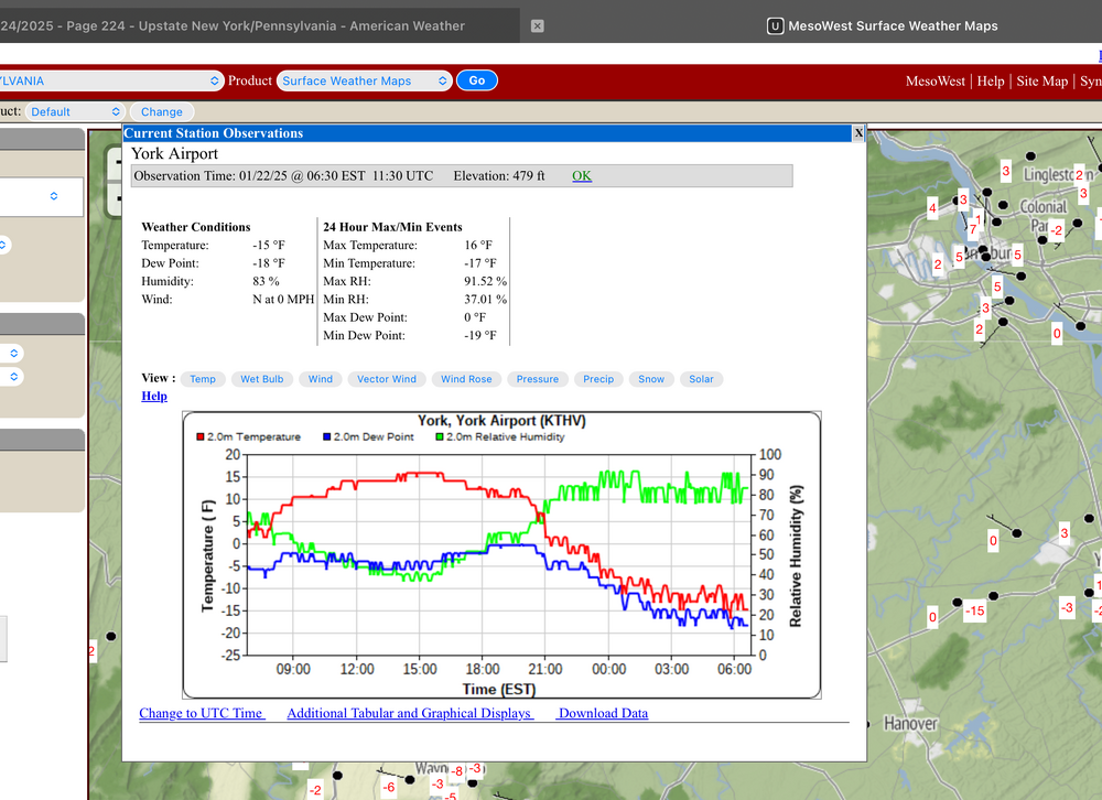
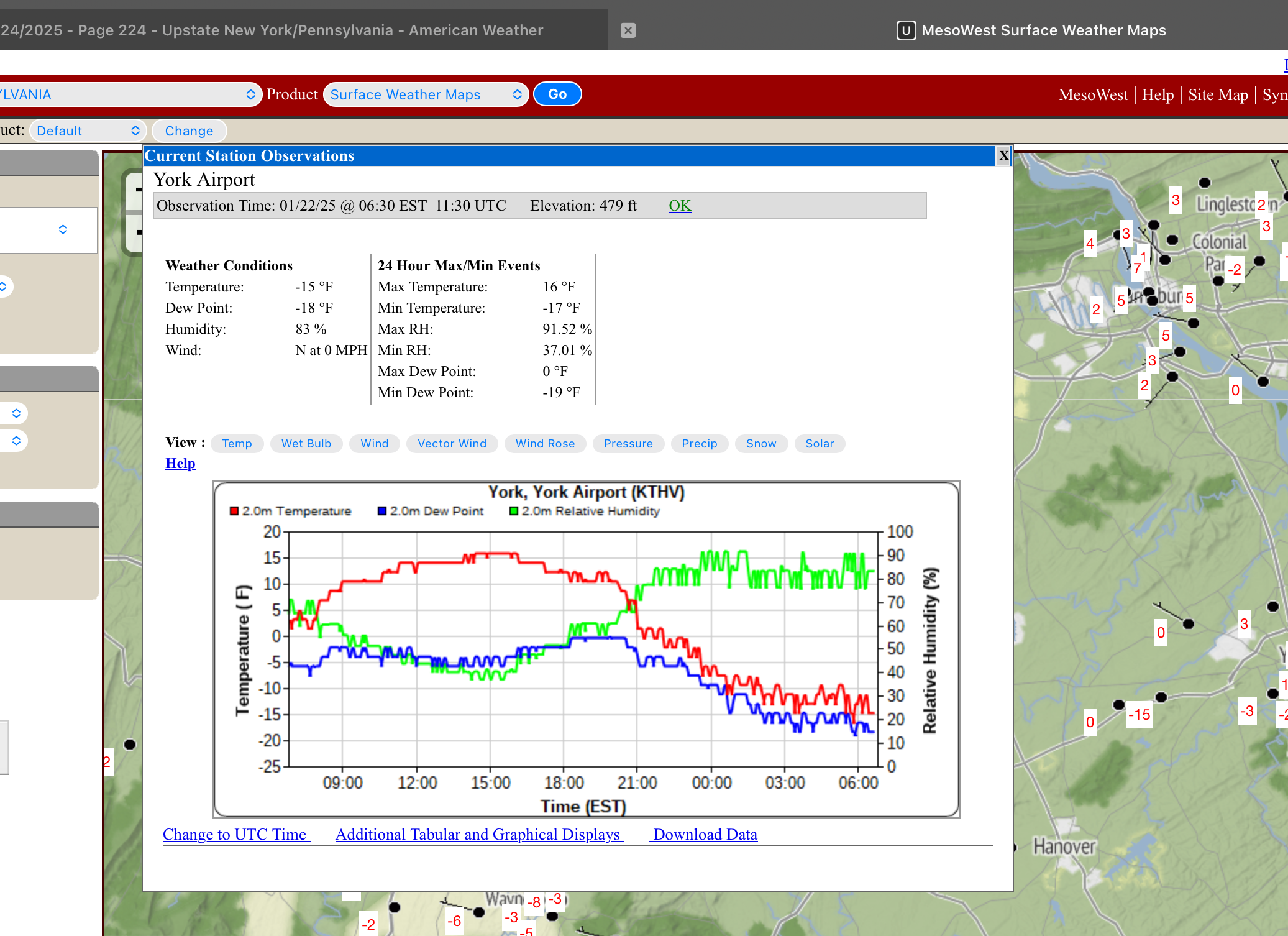
-6.5ºF/-11ºF here so far this morning. I bottomed out yesterday during the 7am hour so possibly some time to get near -10ºF given the dewpoint. Very impressive either way.
On Mesowest it looked like that Hollsopple station between Johnstown and Somerset is below -20 again, and THV was down as far as -17ºF
-
2
-
-
3 hours ago, Bubbler86 said:
That is a beefy clipper on the 18Z GFS; 983 millibars. Some Cat 1 Hurricanes are in this neighborhood.
I know at least one person in here that would get cat 1 winds from that haha.
-
 4
4
-
 1
1
-
-
17 minutes ago, Superstorm said:
New Orleans area has to be see at least a foot by now.
Saw a report of 8.7” from 4 hours ago.
Unreal.
.Some of their 511 cameras look like what you’d see in Buffalo. Good thing the Super Bowl isn’t this week haha.

-
2
-
-
18 minutes ago, mitchnick said:
Most boring 12z runs since I don't know when.
We really haven’t had all the pieces in place at one time to wind up any kind of a big storm all winter despite us achieving deep winter status. Our two signature events this month were a weakening southern stream wave attacking a confluent pattern and this past event being a fairly vigorous wave along an arctic front. It has continued to be a dry pattern. I’ve got about 10” for the month, with zero rain. So take into account these have all been higher ratio snowfalls I’d be lucky to have 0.75” of liquid equivalent for the month so far.
The only real precip opportunity I see right now is that Sunday/Monday timeframe where mainly the GFS has been playing around with some kind of an overrrunning type system. Guidance raises heights in the SE in that timeframe into a really flat SE ridge, though I would hardly call it such. It does moderate temps back to about seasonal and would set the boundary for systems to run through here and not say, the Gulf Coast. Whether there’s anything depends on if any energy gets ejected out of the SW, and both GFS/Euro seem mostly content to keep that closed off low there most of next week. Not real keen on anything else otherwise. There looks like some reinforcing cold next week at times centered on New England (still keeping us seasonal or below), but we’re on the backside of the mean trough. Highly progressive northern branch that is too far NE for clippers here with the sprawling western ridge and +NAO/AO regime downstream. Not much opportunity for phasing if anything does eject out of the SW.
Beyond that I really haven’t seen a lot for me to jump on the complete pattern reversal bandwagon yet. Certainly it looks like a period of above average heights/temps is coming likely near or during the first week of February. But the longevity of that kind of a pattern change is going to depend on some things. Some MJO forecasts completely avoid 4-5-6 or at least phase 5 and others really lower the magnitude eventually into the null phase. If we don’t go full bore and stall out in the those phases, I don’t expect the influence to be such that we have a heat wave and gigantic eastern ridge for any extended amount of time. It will be milder though, regular teleconnections other than the WPO are not particularly great looking. But what we do have that we didn’t last year is much colder air in Canada. That could help press the boundary in a more borderline setup. Certainly a more active storm track would be beneficial snow or not. Still much to resolve out that far.
-
2
-
-
Well we ended up getting the clear, calm night last night I expected tonight and low temps definitely overachieved, showing what rad cooling and a fresh snowpack can do. My low temp here was -4.5ºF.
Some low temps around here I saw from the Mesowest network
Hollsopple (between Johnstown and Somerset): -22ºF
Phillipsburg: -16ºF
Claysburg: -15ºF
Bedford County Airport (KHMZ): -15ºF
I expect similar or perhaps colder numbers tonight, though perhaps more towards the western stations. Weak shortwave passage earlier this evening might make late clearing in the Sus Valley and hold temps up a few degrees compared to last night. But we’ll see.
-
4
-
-
Currently 12°F/1°F here. Ended up with a fluffy 1.1” of additional snow last night to bring the overall total to 4.1”.
-
1 hour ago, WmsptWx said:
I can support this after this cold event. I want to feel negative temperatures and then I want warmth.
You’ll definitely feel them haha. Tomorrow night will be cold enough but I’m still eyeing Tuesday night as the night the bottom might drop out. The latest European for example has Clearfield at -17ºF 7am Wed morning and has been putting out numbers like that persistently as the coldest model also having most of the western half of PA -15ºF or colder.
The reason I think low temps may actually fall to those levels in some non urban areas is because overnight Tues into Wed morning we have a 1040mb high moving into western PA, essentially the “Canadian” High if you will for the insanity about to ensue along the Gulf Coast with the next wave. So that coupled with what is now a fairly expansive snowpack in PA figures to be a good radiational cooling setup and we have a frigid airmass overhead that is in the -20s ºC at 925 and 850mb. Honestly would not be surprised to see a rural station between here and Pittsburgh hit -20ºF if we get the full rad cooling. Probably don’t see temps like that in eastern PA and the Sus Valley but with that new snowpack in place there definitely could be some below zero low temps in the usual cold spots.
-
1
-
-
I did reach my 3” target, which is where I’m at currently. Been in the lighter snows the last couple hours. We missed the business end of that heavy 700mb forced band but we got into it for a little while. All fluff, temps have been about 22-23ºF for most of the event.
-
Already snowing here with a fresh coating and caved roads. Temps fell back rapidly the last several hours from still 33°F at 2am to 24°F right now.
Would like to at least get to 3” with this one. I have yet to even verify an advisory level snowfall this winter.
-
2
-
-
Models have generally seemed to finally hone in overall on the extent and position of the main precip shield. RGEM/HRRR remains the most robust QPF wise. Blending with the other middle of the road stuff I think most of the Sus Valley will verify the warning on the low end, with 5” amounts being common. I think some 6-8” could be had but I think they’ll be focused in some kind of a narrow swath reliant on a band or two setting up. Back in central I think advisory placement and amounts (2-4”) look good. That area coincides more with 700mb being within the DGZ (temps 12ªC falling to around -15ªC at 700mb during best precip). So if a band of snow (and good 700mb lift) gets setup early in the central counties.. they would likely see good ratios. Maybe not 30:1 but 18-20:1 type ratios. I think that’s the path to overachieving for places like State College/Altoona/Clearfield.
So my overall accum breakdown is this:
4-6” for the Sus Valley (H-burg/York/Lancaster)
4-6” for the Laurels (not including post event additional LES/upslope)
2-4” Altoona/State College/Lewistown/Williamsport
3-5” Bedford/Fulton/Franklin
Around 2” in and around Clearfield and T-2” above I-80 (less as you go northwest).
-
6
-
1
-
-
5 minutes ago, CASH_COOP said:
Here are the entries I have as of 9PM:
Canderson 4.8" (.38)
Paweather 8.0" (.75)
GrandmasterB 5.8" (.50)
AccuChris 5.2" (.47)
Jns2183 6.0" (.49)
Itstrainingtime 5.1" (.43)
Cash_Coop 5.5" (.39)
DDweatherman 6.2" (.51)
Mount Joy Snowman (.53)
Less than 3 hours to get your guess in.
4.6” (.37)
-
1
-


Central PA Winter 2024/2025
in Upstate New York/Pennsylvania
Posted
The thing with this pattern coming up in this timeframe is it’s likely that kind of a monster swath of snow is going to materialize in some form in the aggregate sense. Perhaps not as wide, but there’s going to be a swath of big winners from this pattern. Overall as I mentioned a couple days I think it’ll be an upstate NY and New England being the biggest beneficiaries, as they’re also going to total decent snows from tonight and Saturday’s event. That doesn’t mean we can’t score a decent snow event or two.
The big driver in northern PA’s big totals on the 12z Euro (about 30” of it) mostly came from the modeled long duration event that was way out in like D12 or so. To answer your question, the last time northern PA had a swath like that was the December 2020 storm. That had a band of 2-3+ feet of snow up there, including Emporium over to Renovo and on northeast. I do believe it was also the original wsptwx’s biggest ever snowstorm as well.
I think our best opportunity to score a decent area wide snow event that has limited or no mixing is going to come from the thing that’s progged near mid week next week. And there’s a lot to resolve with that, but that seems like the timeframe that lines up with the boundary perhaps being low enough. Beyond I don’t quite think the pattern is going to go really cold yet and we’re going to continue to ride the line. We’re in phase 6 of the MJO right now and models are varying with the speed at which that moves into 7 and eventually the colder phases. We also have some mixed teleconnection signals coming up while we otherwise maintain -NAO/AO and have AK ridging. We’re lucky we’re in the game given the phase 6 MJO, that’s traditionally the torchiest of the torchy phases in JFM. I do still think the eventual end game this month is it will get quite cold with respect to average, but that may be more during the second half of the month.