

MAG5035
-
Posts
5,884 -
Joined
-
Last visited
Content Type
Profiles
Blogs
Forums
American Weather
Media Demo
Store
Gallery
Posts posted by MAG5035
-
-
33 minutes ago, canderson said:
Look at the KMDT obs . It must be funneling down the river. They’ve had multiple over 50 mph and currently at 46.
More robust daytime heating at the surface over there probably resulted in higher wind gusts mixing down this afternoon. High res guidance increases the winds aloft overnight into the early part of the day tomorrow. So similar gusts are likely to continue.
My high gust at home today is 32.4mph and most of the ASOS and RWIS around here (KAOO, KJST, etc have had max gusts in the 45mph range so far.
-
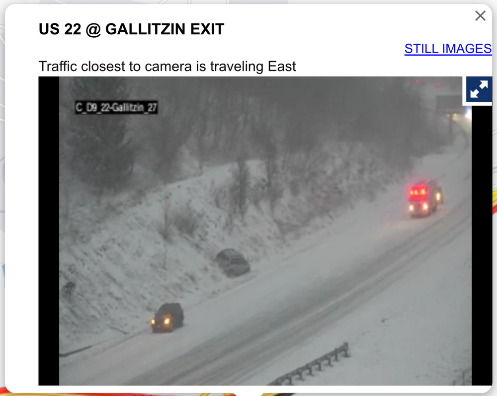
Laurel’s are looking pretty rough, specifically on the US 22 corridor right now in Cambria at the top of the mountain above Altoona.
Pretty wintry down here too, with a coating of snow on the ground and occasional heavier snow squalls blowing around. But roads are uncaved at the moment. Temp is 30ºF
-
 1
1
-
-
1 hour ago, Atomixwx said:
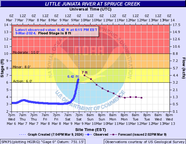
Frankstown Branch of the Juniata by Birmingham on Rte 453 is close to caving the road. There is so. much. water.
Sent from my motorola edge 5G UW (2021) using Tapatalk
I’d imagine the gauge station down the road from there near Spruce Creek will get above flood stage and they’ll need an actual warning for that branch which is the Little Juniata. Moderate flood stage at 10ft is roughly the benchmark for the road caving to the river along that stretch of 453.
 r
r
Frankstown Branch follows 22 to Hollidaysburg, that one might be close to needing a warning too. This has probably been the highest QPF event of the winter around here outside of the 1/9 warning snow to 1”+ of rain. Got 1.65” in the gauge with one more wave of rain to get through this eve.
-
5 hours ago, Bubbler86 said:
They may need to issue a WSW or Advisory for the Laurels. Temps may be a reason they do not but might be close. Several meso's show 4-6" and Nam is around 8".
Certainly an advisory looks probable there, and possibly some of the other counties in western PA along I-80 outside of the snow belt immediately off of Lake Erie. Temps at elevation in the Laurels look to be plenty cold (falling into the mid 20s Sunday), so snow will likely pile up once it gets going. Once east of the Laurels likely nothing major accum wise, however there could be some potent squalls that traverse the central counties on Sunday.
With regard to WSW potential, duration is likely a factor in probably not seeing amounts like that in the Laurels outside of the very highest elevations. The back lash event itself looks potent though, with -10 to -12ºC 850mb air coming across the well above average and unfrozen lakes. Couple that with March solar and daytime instability and I think we’ll see some long reaching squalls and potential snow squall warnings especially in the central part of the state as mentioned. Surface temps in the Sus Valley will be warmer but anything stronger that makes it over there will likely crash temps and become snow.
-
2
-
-
60ºF was the high here today, mosquitoes are out for blood.
-
I don’t usually post snapshots of ops in the long range but might as well throw this one in here with the other maps.
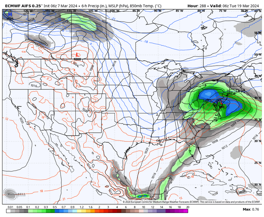
This is the new AI generated Euro model. I saw the Mid-Atlantic folks sharing this occasionally down there and now WB has put it on their site in the last day or so. So there’s that.. it is nice that it goes all the way out to 360 on all 4 daily runs. Also noteworthy is that it has been very cold in the D10-15, with major negative departures in Canada getting into the northern US. So will be interesting to monitor how this does. Perhaps the AI Euro has “learned” that the 3 out of last 4 winters being garbage winters all produced garbage springs too haha. With two of them (19-20 & 22-23) producing snows in some portion of PA in May and the other one (21-22) with a snow event in the central counties in late April.
At any rate, ensembles have been clearly showing a major nosedive of the EPO during roughly the 3/13-3/17 period and staying solidly negative for at least several days beyond that. So that period around St Patty’s thru about the 23rd is likely one to watch. This transition of the EPO is pretty well within the ensemble range where there would be some skill in forecasting, so barring any major changes in the near term (possible of course) it would appear this pattern shift will occur despite what the MJO is doing. I think the question will be how much cold air gets involved and how long the -EPO regime lasts. That will have implications on how cold/warm the rest of month into early April is. The MJO pulse is a pretty strong one, but is forecast to move quite rapidly from 4 to 7 pretty much in the next 10 days. So I wonder if it’s influence on our pattern might be tempered a bit by its rapid progression.
-
5
-
 1
1
-
-
9 minutes ago, Atomixwx said:
Seventy.
70.
S E V E N T Y
E
V
E
N
T
Y
Sent from my motorola edge 5G UW (2021) using Tapatalk
Only 55 and low overcast here. The valleys are really doing their thing today with the cool air damming. I bet all I’d have to do is drive to the top of Wopsy to get into the sun.

-
Results are in for my Feb forecast.
QuoteMichael,
Congratulations on ranking 9 out of 83 participants in WeatherBELL's February Forecast Competition! You've shown impressive skill in long-range weather forecasting, beating 4 out of 7 models and all 6 members of the WeatherBELL team!
Your total error score over all 12 cities was 54.5°F, with an average error of 4.54°F and an average bias of -4.54°F. You forecasted the correct sign for 7 out of 12 locations, and your best location was "Seattle Tacoma International Airport" with a forecast bias of +1.3°F.
Thanks for participating, and good luck in the April Forecast Competition! Enter your forecasts between Friday, March 15 at 12:00AM ET and Thursday, March 21 at 11:59PM ET at the following link to qualify. https://competition.weatherbell.com/forecast-entry
The WeatherBELL Analytics Team
Despite the placing I was still biased way too cold, but part of that is a testament to just how warm the month was. I went +5 at Minneapolis for example and the month finished +12.7ºF.. which is insane. Happy I opted for doing + departures in the NE/north-central/Ohio Valley stations at least. Final numbers had to be submitted by like Jan 21st, so that was in the middle of the biblical February incoming disco. That was when the MJO was showing signs of being slow with progressing to and beyond 8 and we know how that ended up with the pulse refusing the cold phases. With that I had expected the good pattern to come but delayed, and we just never got it. Expected the southern US to be colder than average with an active southern stream and even there ended up solidly above average.
Which 3 models did better? GEFS extended (2nd), Euro Seasonal (5th) CANSIPS (6th). GEFS extended only had a total error of 25.8ºF (avg error of 2.15ºF).
Euro weeklies (44th) had a 69.6ºF total error (avg error of 5.8ºF).
-
7
-
-
1924z-ers, it’s warm. 65ºF here currently.
-
6 hours ago, Blizzard of 93 said:
ALEET ALEET… The 6z GFS is not listening to the “it’s never gonna snow again” crowd.
Might as well post the maps for next Sunday night just so everyone can dissect why it’s impossible…
I know you posted this in the neighboring thread as well but our subforum has been actually pretty good with the negativity all things considered.
1 hour ago, Itstrainingtime said:This is the most accurate public forum post that you have ever made.
I also mow the grass for both of my neighbors in addition to mine, so my question for the competition committee would be do they count individually? Because that might be the only way I’m competitive since regardless of whatever happens this month.. first mow (aka mulching twigs and branches) usually happens about the second week or so of April around here haha.
-
1
-
Some pingers with the onset of precip here. 43/22°F
-
2
-
-
7 hours ago, Atomixwx said:
That Toontown graphic is going to be the Troll signal with only one of those winters listed being outside the last 25 years.
Sent from my motorola edge 5G UW (2021) using Tapatalk
Speaking of toontown, a picture of this has somehow got WTAJ’s attention of putting up an article of whether or not this was a tornado around dawn yesterday morning.
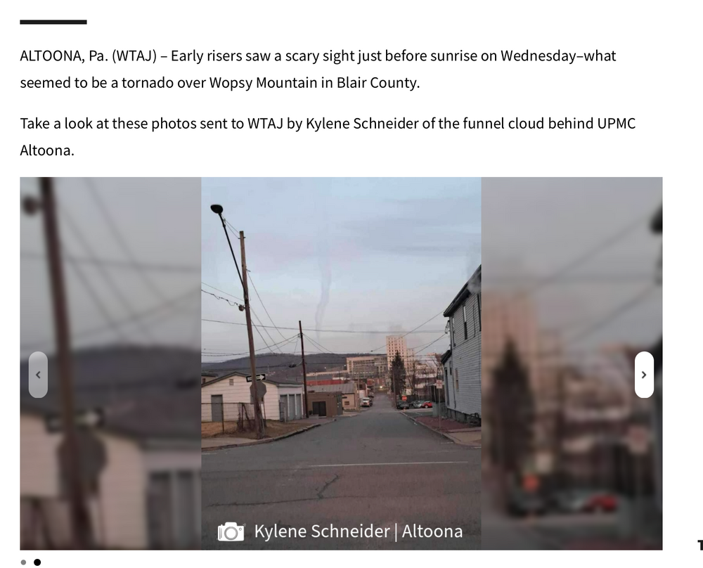
https://www.wtaj.com/weather/local-weather/photos-was-there-a-tornado-in-altoona/
Blair County has had like 2 actual confirmed tornadoes within the county since 1950 and it shows haha.
-
5 hours ago, Blizzard of 93 said:
Yes, please….
A better look by March 12th this run.
The problem I continue to see is temps. Here’s the temp departures to go with that timeframe.

I just don’t think we have enough cold air involved in the overall pattern to make the undercutting storm track/below avg 500 heights with anomalously low heights also remaining out west thing work if it were to come to fruition in that fashion. Certainly now since we’ll be approaching mid-March here. Near normal to slightly + temp anomalies at our latitude isn’t going to cut it and would make a scenario to score a winter storm much more difficult. We need to build western ridging (PNA realm), at least temporarily or something to set up an alignment that might draw down enough cold to work with for late season mischief. The latest Euro weeklies try to do that from around St Patty’s day onward with a rapid reversal to ridging up the Pacific coast toward Alaska, resulting in a much better source region and associated cold anomalies that it puts on a large part of the CONUS (week 3 and esp week 4). GEFS extended is also a similar evolution and timeframe (a bit less robust with the cold). I personally think the GEFS extended has done a better job this winter (esp in temps) so seeing some agreement there is probably not a bad thing. Latest MJO evolution is a bit interesting, with forecasts looking to show a pretty strong pulse starting in phase 2/3 and making a run around the ring. Extended ensembles take it around to phases 6 and 7, which are the strongest correlated phases to warmth in the east during FMA.. so that’s a bit a of a discrepancy to work thru. That may make a potential window later in the month to score something much smaller, or the MJO forecasts could continue to evolve differently as well. I’ll be curious to see how things are when we get that period beyond the 15th or so solidly into the regular ensemble range.
-
1
-
1
-
-
Nice Feb 27th summer night. Fair amount of lightning and thunder (elevated instability) accompanying the wave of precip crossing central PA. Temp here is “only” 48ºF.
-
16 minutes ago, mahantango#1 said:
I see this for tomorrow.
Cloud cover and associated lack of CAPE generation tomorrow would figure to be an inhibitor in severe around here with a couple waves of rain (maybe some thunder) progged to traverse PA during the day. 3k NAM seems a little more suggestive of getting some CAPE into NW PA prior to frontal passage there in the early afternoon. Helicity/shear is moderate-strong, so the combo could suggest some imbedded rotating elements to any line or bow segment that develops there. Think for our area the biggest potential will be with the FROPA, which could bring some damaging winds to the surface if we have a fairly well developed line that comes across. Both HRRR and 3k are generating little CAPE from the eastern 2/3s of PA.
Nothing like the Midwest today, which is solidly in the warm sector and daytime heating. Pretty wild to see 1500-2500 CAPEs generated in northern ILL/IN and all the way up into the lower Peninsula of Michigan with widespread temps in the 70s in those areas.
-
3
-
-
26 minutes ago, canderson said:
I thiiiiink warnings require sustained in the 30s.
Sustained >40mph and/or gusts 58mph or greater for a period greater than at least an hour. Yep I was ninja-ed haha.
Probably looking at advisories of the 50mph gust variety with this, outside of Cambria/Somerset which may have just enough for a warning. High res stuff doesn’t look extremely crazy. 850mb winds are only getting to the 45-55kt range overnight tomorrow after the frontal passage.
-
1
-
-
1 hour ago, Itstrainingtime said:
It is - this week is the 6th anniversary of a big severe outbreak in February 2018. I was under a Tornado Warning, confirmed funnel cloud over eastern York County. That ended a couple of days of temps in the 70s, one of which I hit 78.
I would take what happened in March/Early April 2018 after that insanely warm February again in a heartbeat. Had almost 2 feet of snow after March 1st and still my biggest snow event personally since Feb 2010 (March 21st 13.2”). Not sure if that’s in the cards this winter but that was def one of the wildest late winter reversals I remember. That was the last winter with an early Easter too.
-
1
-
1
-
-
Most noteworthy weather item I see in the short-medium range is a strong frontal passage this coming Wed Night, which has been pretty persistent on guidance. Perhaps worthy of some kind of a brief changeover at the end and a sharp temp drop with some windy weather Thursday. Aside from a brief shot of some cold tomorrow and tomorrow night, thats about it in terms of cold or snow the next 6-10+ by the looks of it.
Thru 15 days all ensembles maintain +EPO/WPO and only take a really negative PNA to a somewhat less negative PNA. Until we turn the tables with those teleconnections we’re going to continue to deal with mild, modified Pacific air at the lower levels dominating the lower 48 even if we get NAO blocking that starts developing and helps undercut some storms. Just the story of the winter really. It was 53 for a high here this afternoon, despite 18z models initializing with <540 dm thickness over most of C-PA. There’s just no low level cold.
-
1
-
-
1 hour ago, Atomixwx said:
Big loser of Estadio Beaver being winterized is Cumberland Valley School District, as I guarantee the second the giant erector set is able to host the PIAA State Football Championships, they're headed to State College.
Sent from my motorola edge 5G UW (2021) using Tapatalk
I’m pretty sure the real reason it’s being winterized is because of the new expanded CFP. Home teams in the bracket would be hosting at their own stadium for the first round of the playoffs (slated for Dec 20-21 this coming season) . Not that you could do much to winterize the parking situation with all the grass parking around the stadium if it were to actually act like winter in mid-late December.
-
1
-
-
57 minutes ago, Itstrainingtime said:
I just came in and this was the first post that I see - I was just watching a video that Elliott put up online this afternoon. Holy crap is he on the spring train. It's like a foregone conclusion to him it seems. Might get very interesting if something goes awry...
That said - and I've said this repeatedly. I want more snow. It's still February 22nd. It's not mid April. But, if it's not going to snow like legit snow...meh, let's move on. I've transitioned to spring clothing now (short sleeves and shorts) from my winter clothing (short sleeves and shorts) so it might as well warm up if there's no wintry precip to be had.
I think he’ll look pretty good on that conclusion thru about the first week or so of March. Beyond that is still to be determined. Some reversal in the PNA/EPO/NAO/AO are noted in the longer term with the NAO/AO being shown to neutralize and go back negative by the end of the range of regular ensemble guidance. The Pac related stuff (EPO/PNA) is further out. Euro weeklies are more bullish than the GEFS extended dumping the EPO by mid month. MJO forecasts are mainly into 4 and maybe a bit of 5 (noticed the GEFS was into 3 today). FMA Phase 4 and 5 is not the blowtorch it is during DJF or JFM and 3 is a cold phase in March. So I don’t think the MJO is really a slam dunk using it to declare spring fully sprung before mid-March.
Otherwise, this might be an understatement but I haven’t been particularly impressed with the Euro Weeklies performance this winter. The GEFS extended has been demonstrably better with temps at longer range (Euro weeklies have been too cold). I can see why Elliot’s all in on spring just going on how the rest of the winter has gone. We typically pay dearly at some point when we have a mostly warm late winter though. Whether or not that happens in time for it to matter ( for viable snow opportunities) is the main question I’m focused on when approaching later next month.
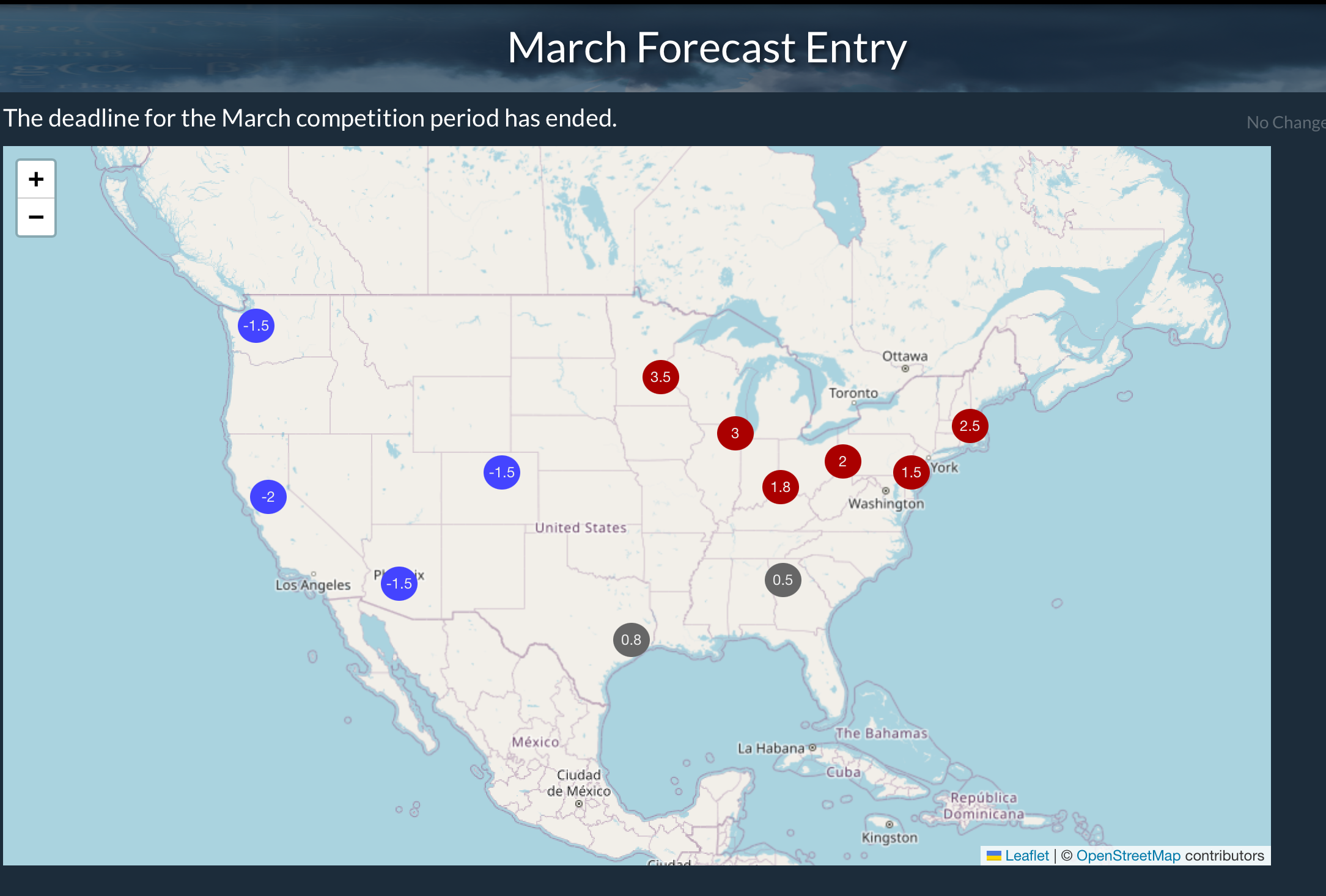
Speaking of forecasts, here are the numbers I decided on for March with WB’s forecast competition. .
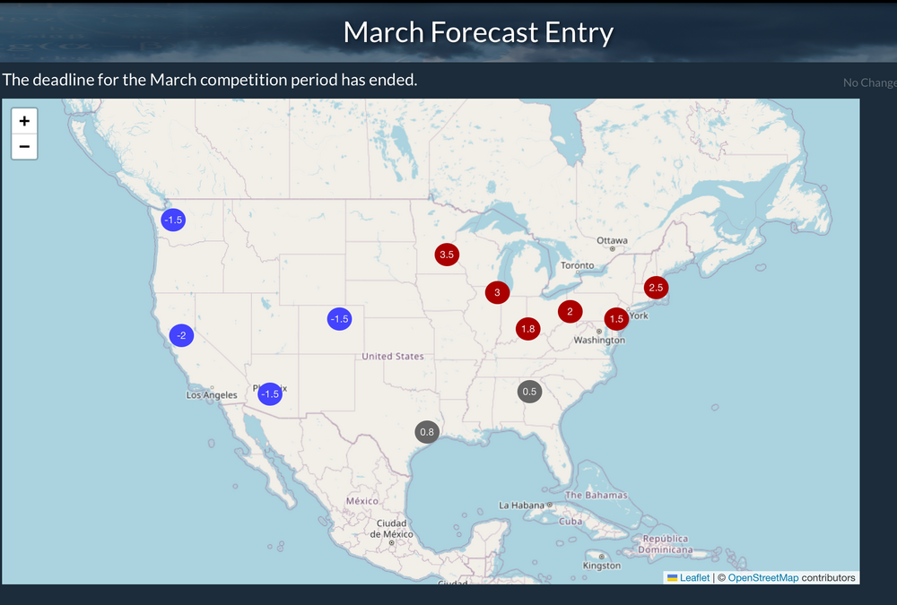
I originally was leaning colder in the east but the first part of the month just looks too warm. I think unless we have a truly massive second half reversal in temps we’ll be struggling to get the numbers back down to average even with a second half cooldown that’s enough to generate a couple snow chances. That’s how I approached February and I actually picked small + departures in the east anticipating the second half of the month to eventually turn cold but it just never did get cold this month and the + departures all over the US have just run away like they did in December. I picked +5 in Minneapolis which is not a small departure and they’re still at +14ºF for Feb.
-
5
-
2
-
-
2 hours ago, Bubbler86 said:
Ditto here. Shade snow hanging strong but too much rain will push it.
I might’ve had a mix right when it started. I got what appear to be pinger holes in my shade snow haha.
-
5 after nooners, 36°F and rain
-
3 hours ago, Itstrainingtime said:
I thought about this yesterday - I was planning on taking report cards for winter later in March when winter was over for sure. I still plan on doing so.
This will be fun because each of us has our own criteria - there really isn't right or wrong. It's our own perceptions.
Some factors I will consider for my grade:
- 1. Comparison to most winter forecasts leading in vs reality
- 2. Comparison to last year
- 3. Snowfall total
- 4. Snowfall longevity
- 5. Cold - how much cold, how cold did it get?
- 6. Snow hype versus reality - were we constantly let down or not?
Some of those mean nothing to others, while others might have criteria that I didn't list. It's truly subjective.
I’ll do a late progress report as it pertains to meteorological winter (DJF)
1. C-D ish on average. I think most generally expected a warmer start to winter and the potential for storms and cold to be later in the winter. I did not anticipate the warm December the CONUS ended up with at all, that probably should’ve been a hint. We have had opportunities and some of them have delivered but it has just not wanted to be cold for any longer stretches this winter. And we’ve had a couple bigger storms but we haven’t had pattern alignments conducive for phasing, and it’s been mostly either southern or northern stream waves… which limited opportunities for a KU type event.
2. C+. The pattern itself has been overall more favorable than last year, especially with storm track. Most events have went under or tried to go under PA (transfer). We’ve only really had maybe a couple straight up cutters, and one of them ended up delivering my biggest snowfall of the season to date. There’s just been no cold air, there’s no persistent ridging in the PNA/EPO realm to help deliver any cold when it has actually been in Canada outside of the middle of Jan.
3. B. I’ve personally had two winter storm warning verified events and 4 other advisory caliber ones at my home, which isn’t half bad to this point. A one off big hitter sometime in March (like a March 22, 2018 or better) would get me to a total I would consider to be in the average range here. Same could be said anywhere else in C-PA and the northern Mid-Atlantic. And of course there’s that stripe of eastern PA in the Lehigh Valley/Poconos that is already near or at average. Honestly, that we’ve achieved that considering how warm the winter has been temp wise in the northern half of the country is a small miracle.
4. D. I’m big on pack retention, and this winter hasn’t been a good one for that. The middle 10days or so of Jan and getting to snowboard Blue Knob at 100% twice saves me from giving this criteria an F.
5. F. There just hasn’t been any cold pattern that has stuck this winter. The one we did get in January was delayed. The Jan 6 and 9th storms came before it was actually cold, and the below normal stuff came mainly centered on about 5 days or so, where we scored a couple decent advisory level northern branch systems. The MJO’s two week+ meandering in Phase 7 after running thru 4-5-6 and then subsequent failure to run thru 8-1-2 despite what is likely an all time record reversal of the SOI from Jan to Feb probably has a part in what sunk this month overall for any kind of a truly cold pattern.
6. F-. The hype in late Jan for what was being shown at the time in the weeklies/ long range ensembles was off the charts. Not necessarily in here, but some folks were all in on that 2010, 78, 58 type pattern. Reality ended up being meh but it’s been way worse in the snow dept, but the expectation of a big storm pattern and cold made this month a huge disappointment and later in the winter was where forecasts were being focused on for delivering the goods.
If winter ended now I’d give it a C-, aided mainly by the snow we did get. But we got March, and I’m not writing anything off in that month yet.. esp second half of the month.
-
1
-
2
-
Also, meltdown of my gauge yielded 0.26”, so counting the extra 0.3” that fell (5.5” total) before I brought it in yielded a 21 to 1 ratio. Which looked on par with other obs that had SLR’s included.
-
1
-


Central PA Winter 23/24
in Upstate New York/Pennsylvania
Posted
Last night was blustery but not overly windy down here, but it’s been a different story this morning though since just before daybreak. My station registered a high gust of 59 mph around 715am and there’s been plenty of 40+ gusts.