

MAG5035
-
Posts
5,884 -
Joined
-
Last visited
Content Type
Profiles
Blogs
Forums
American Weather
Media Demo
Store
Gallery
Posts posted by MAG5035
-
-
I’m nearing about 1.5” from the snow today. Temps have rebounded to 26ºF after starting today at 13ºF.
Some historical perspective on the upcoming cold snap next week from CTP:
QuoteColder air will begin to filter into the region Saturday night into Sunday as well, with a reinforcing shot of bitterly cold air arriving Sunday night into Monday. Temperatures will bottom out Tuesday, with highs running 20 to 30 degree below average. Considering that late January is the climatological coldest time of the year, highs that far below average means that we are in for a significant bout of arctic air. To put the upcoming cold in historical perspective, if the forecast holds, about 80 hours with temperatures in the mid teens or colder at Harrisburg and Williamsport rivals the cold snap of Feb 1996 in terms of duration. For State College, 3 days with highs of 12F or lower only happened once in the past 100 yrs, in Feb 1971. It did also happen a few times in the 1800s.-
 3
3
-
-
20 minutes ago, Bubbler86 said:
Eurochatgpt is not far off though cannot see all the details.
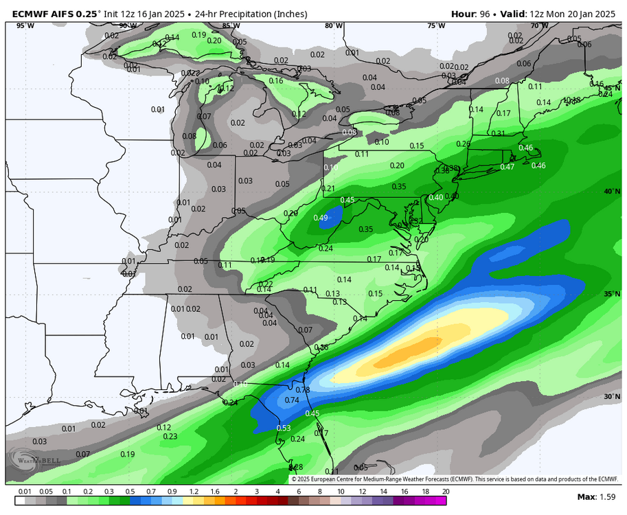
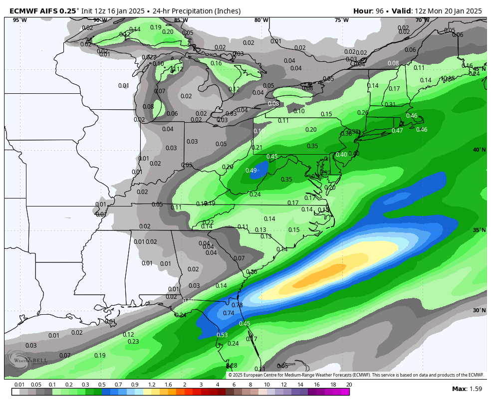
Here’s the QPF map for it, haha. There’s no snow maps for it available.. least on WB. Def still on a continued wetter trend vs the last couple runs in PA.
-
 2
2
-
-
43 minutes ago, Bubbler86 said:
There is a recent anti-Kuch theme in the MA, but if I post qpf someone is just going to post Kuch so here it is.
Haha I wouldn’t worry about whatever they’re worried about. Kuchera is fine if one recognizes how the method is calculated and applies it to the thermal situation you have. Judging by a cmment or two down there some don’t want to go that extra little bit. Any rate neither 10:1 or Kuchera actually applies actual atmospheric physics (VV’s, etc).
Kuchera basically takes the warmest temp within the surface to 500mb level and cranks out a ratio via a math equation. Where it’s not the best choice is when there’s marginal surface temps (freezing or a degree or two above it will be too low) and significantly colder arctic air masses (it will put out unrealistically widespread areas of 20-30+:1) . Otherwise it does fairly well. The new really amped up RGEM that just came out dumped 9.1” at Harrisburg via 10:1. It also cranked out 9.1” via the Kuchera method as well.
-
1
-
-
Definitely still a good bit of discrepancy with this Sunday thing. Shortwave timing is important in addition to what the models are doing with it. Canadian/RGEM seem to be a bit faster than the GFS and Euro, which in turn erupts the wave through most of C-PA as the arctic boundary hasn’t pressed further SE given the faster timing. I wasn’t really optimistic about much of anything in PA from this originally but I do think the chances of at least the LSV seeing a bout of accumulating snow are looking increasingly more possible.
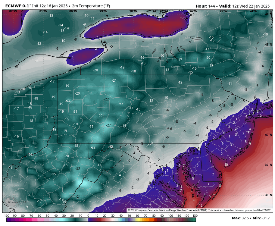
Surprised not much mention of the cold behind. Mon night-Thurs morning are going to be very cold.. culminating with I think Wed morning being the coldest morning of all with an already noteworthy arctic airmass in place and a radiational cooling setup that particular night. Euro in particular literally rivals January 94 in western PA with the morning lows. Not sure it’ll be that extreme but I do think the GFS may be a bit too warm in areas that have snow on the ground. Obviously if that Sunday wave puts snow down in the Sus Valley then that will invite the opportunity for more widespread below zero low potential there on Tues/Wed night.
For example sake here was what the Euro has 12z Wed morning. (These are actual 2m temps in ºF)
-
1
-
1
-
-
Moderate snow, working on about an inch here.
-
1
-
-
Light snow here and 21ºF. Light coating so far.
-
2
-
-
10 hours ago, Blizzard of 93 said:
This should cheer everyone up a bit…
DT’s last call map for the light event tomorrow night.

I like the well placed RIC 6”+ jack haha. Must be rolling with the HRRR for that particular area. Sure isn’t the Euro putting out numbers like that down there. The 12z HRRR and NAM runs this morning appeared to be the best scenarios for here C-PA, holding an area wide 1-2” or so. Rest of everything including the the NBM suite continues to be pessimistic in the Sus Valley. GFS was okay I suppose. I think a good expectation for the Sus Valley is generally up to an inch of snowfall for all and we’ll see if we can get a couple bands that deliver a bit more in spots. AOO/UNV corridor slightly better with 1-2” and Laurel’s with 2-3” before their typical LES/upslope regime sets up.
-
1
-
-
17 minutes ago, Bubbler86 said:
That one intercept he threw was woefully underthrown and any PI that may have happened on the play had nothing to do with it.
You mean the end zone play where we found out which Notre Dame fans are also Browns fans? Haha
-
 1
1
-
-
30 minutes ago, pasnownut said:
It was a great game, and better than many expected (me thinks). I know there are a lot of Franklin haters, but he earned his keep this year IMO. PSU surely had momentum last night. Someone had to lose and usually in a great game it comes down to who made least amount of errors. Allards late int was crushing.
It came down to two things for me. The interception at the end obviously, but also where ND tied the game back up on the wide open long TD where the DB just simply slipped and fell on his break. Might have been a different situation at the end of the game if that doesn’t happen. But it is what it is. Allar had a bad game/choices and that wasn’t a good time for that given Notre Dame’s defense is ranked #1 in completion percentage (50.7%) and #3 in pass yards/game (165). That game gets to OT or even just further down the field for the win at some point he was going to have to make a key throw.
-
2
-
-
54 minutes ago, Itstrainingtime said:
You're soft. It's 31 degrees. Great day to be walking along the river.
")
Wagons south on the AC thermostat haha. It’s only managed to get to 22ºF back here today.
-
2
-
-
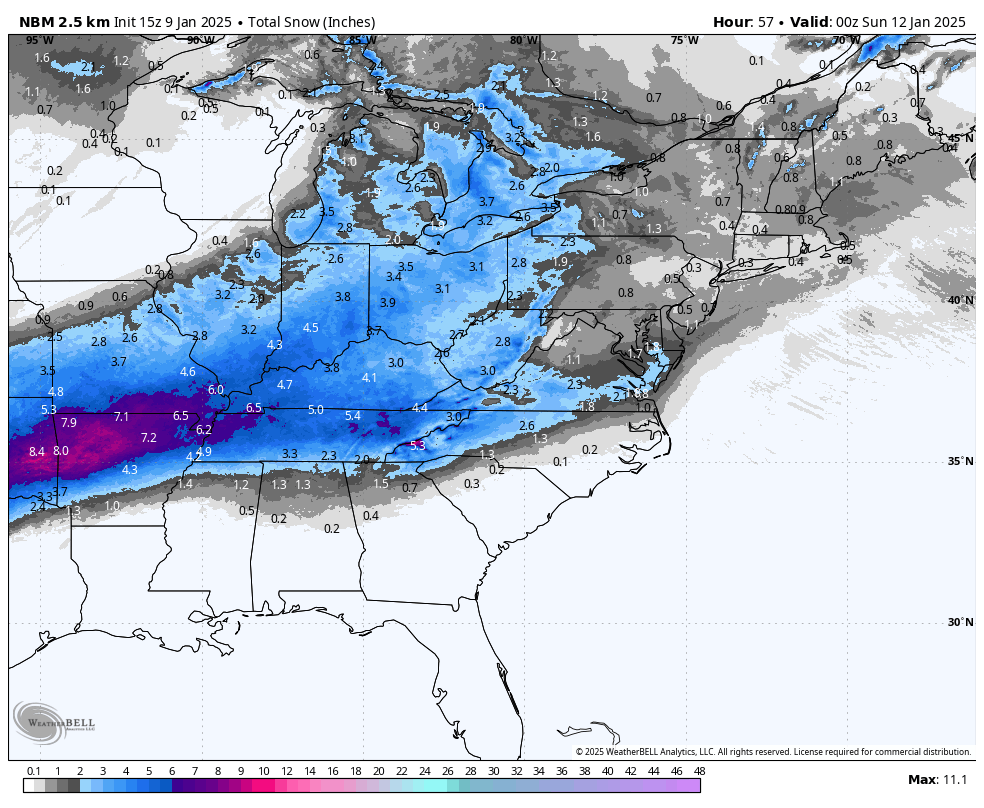
Here’s the 15z NBM,
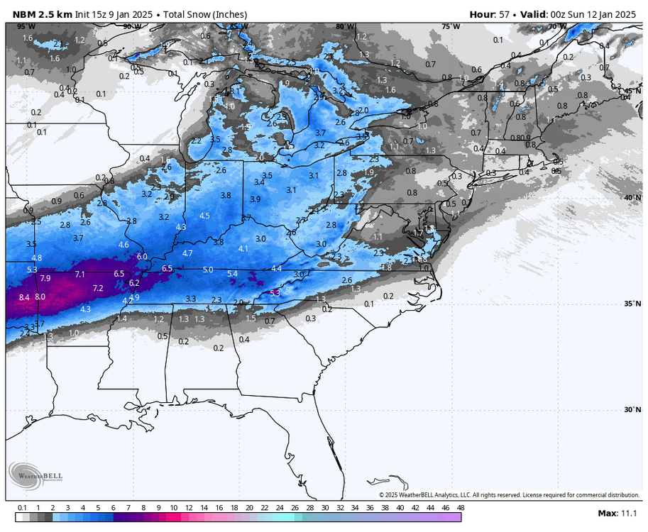
CTP’s initial snowfall forecasts are following that fairly close so far. That covers the whole duration of the event through the rest of the NE and such. So the blend that makes up the NBM is quite pessimistic on that broad area of light to moderate accums getting on the other side of the Apps except for that stripe thru VA and the Delmarva associated with the coastal currently. We’ll see if it eventually improves a bit like some of the op’s did today for the area. Either way, definitely a shame this system can’t amplify at least some. That is a huge expanse of accumulating snowfall from Texas thru the Ohio Valley.
-
2
-
-
1 hour ago, Voyager said:
So I'm not as weather savvy as some of you so I'm wondering, why are we getting these consistent, unrelenting high winds? Usually we have a windy day (or two) after a storm, but then they subside. The cold I can handle, even though it sucks when you haul water for a living, but the wind that's going along with it is just brutal.
We’ve had a persistent NW cyclonic flow via the deep low in the 50/50 realm being locked in by blocking regime in place..recently reinforced by Monday’s storm. Look for another windy day today in C-PA…especially eastern and northeastern zones, where the neighboring Poconos counties actually are under wind advisories today. High pressure builds in tonight/tomorrow ahead of the likely light snowfall Friday Night, and winds should finally settle down.
-
2
-
1
-
-
10 minutes ago, Bubbler86 said:
I think 2-4 here (most of this sub), if the NS Vort can get close enough, is not out of question.
It would likely only take a swath of one to two tenths QPF to get there. Thermals are great for high ratio snows (potentially in the 20:1 realm) with most of PA residing at or near -8ºC at 850ºC and -10ºC and lower at 700mb. That’s what I’m eyeing out of this event, a potential swath of 2-4” snows where some marginally better forcing aloft coincides with the nice thermal column. Sus Valley is the question area right now for me, though tonight’s NAM looks better so far. I def could see the shadowing effect occurring in a weaker interaction with the northern stream as the southern shortwave ejects out towards us and the SW flow downslopes off the mountains, especially as a secondary develops and tightens the remaining precip down to the south.
-
3
-
-
The late afternoon back end delivered only about another half inch here, making the storm total 1.8”. Just missed it all today haha.. the best 850mb FGEN to the south (expected), the best 700mb FGEN to the north (not expected), and lastly the 500mb vort pass to the south which by the obs down there has gotten the Mid-Atlantic folks fairly close to their forecasted totals.
-
1 hour ago, WmsptWx said:
Probably 2.5" if I had to say from eyeballing. It was enough to undo any clearing attempts that was made after Saturday morning's shock event. It was more than I expected.
You might have a chance at some more surprise bands the next couple days. High res models are showing a Huron connected band developing Wednesday with a favorable alignment through your general area and perhaps into State College again.
-
My initial thoughts with the end of the week system is I think there will be at least a wave of lighter snows that moves through the commonwealth as the southern system over system ejects out and there’s a least some interaction with the northern stream. Euro hangs it back and northern stream diving in ahead shears the southern energy out. GFS has been trying to phase it, and through 102hr it looks like the 18z GFS is going to really be quite a solution.
-
2
-
-
4 hours ago, WmsptWx said:
It would appear as if the snow has stopped.
How much did you end up with this morning?
-
1 hour ago, Bubbler86 said:
Interesting and obvious thoughts in the MA forum. I say obvious because they are but not sure I had thought of it yet. We were so gung ho on using Kuch because of the antecedent cold air but if one looks at the 10-1 maps maybe the model outputs were a bit more realistic. QPF in Lanco was 2-3" on a lot of outputs....10-1 that is 2-3" of snow. It is almost 30 degrees here right now. Kuch may have over done it this time (sometimes Kuch is lower of course but obviously much higher up this way for this storm.)
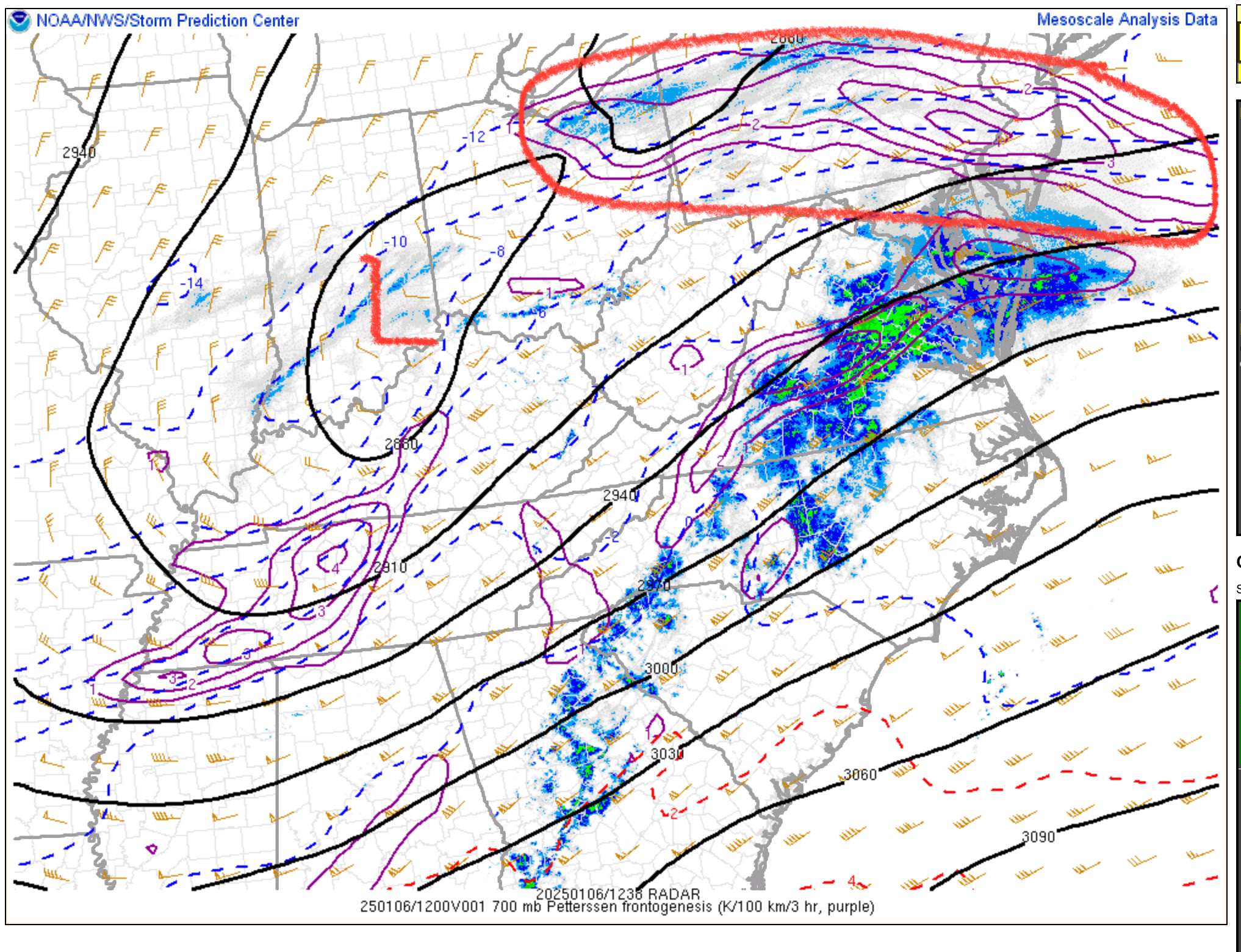
I think their lower ratios down there were more of a result of what was going on aloft, especially in the mid levels. Here’s some mesoanalysis maps at 11z this morning one at 700mb and the other at 850mb. At 700mb, a lot of that subforum was between -2º to -4ºC and was so overnight during the bulk of their snowfall. Cold enough to maintain the snow column of course but those are very warm temps at that level, and would have promoted poor snow crystal growth. They had the better forcing at the 850mb level and 850mb temps were roughly the same as the 700mb temps.
700mb at 11z

850mb at 11z

These 850mb and 700mb features were also fairly far to the north, especially the 700mb low.. which was why the best lift probably ended up where it did this morning. I’ve mentioned the secondary max a couple times since Friday, and noted the Euro had it about where it actually ended up on its 12z run yesterday. I didn’t anticipate the big separation between the two though. I expected the 700mb forcing to be in position to boost totals in the bottom two tiers of PA counties. I also expected the meso models to at least pick up on this stuff a little bit prior to the event arriving. They really didn’t.. the northern PA band ended up being more of a nowcasting deal. This was already a fairly progressive system given the setup and positive trough orientation, and I think it just ended up being more so in the end.
On 1/5/2025 at 2:31 PM, MAG5035 said:One thing at the mesoscale level I noticed on the 12z Euro is that despite it remaining on the lighter side with overall snowfall it managed to have a secondary band of enhanced QPF that extended from Pittsburgh to Clearfield to Williamsport, giving our northern folks in those spots approx 2-4”. Stuff like that will be need watched for on the meso models as we get close to start time.
On 1/3/2025 at 1:49 PM, MAG5035 said:I’m not budging from my original thinking quite yet of advisory snows I-80 south and warning snow potential in the bottom two tiers of counties across C-PA. I may eventually concede one or both of those tiers but I want to see the short range play out more, as we’re just barely into range of the NAM/RGEM and not even into the longer HRRR range. That stuff is going to see how the overall precip shield sets up better. I think we’ll still eventually see a more widespread snow shield into PA even if it’s lighter snows and we concede the whole swath of 6”+ to the DC folks. But if that happens the northern tier above 80 and especially NE PA might not see much.
Other thing to consider may be a secondary swath of higher snowfall due to better ratios. Lift would be further aloft (700mb level or a bit higher) in a further south solution and temps are plenty cold up there for good snow growth in that scenario with this storm and on down the column as well (less than -8ºC at 850mb on the Euro).
-
4
-
-
Only 1.3” has fallen so far, woof. Starting to get some of this backend stuff but it’s gonna have to do some work. I was targeting about 4-5” here. I’ll be lucky to get 3” to verify the advisory.
-
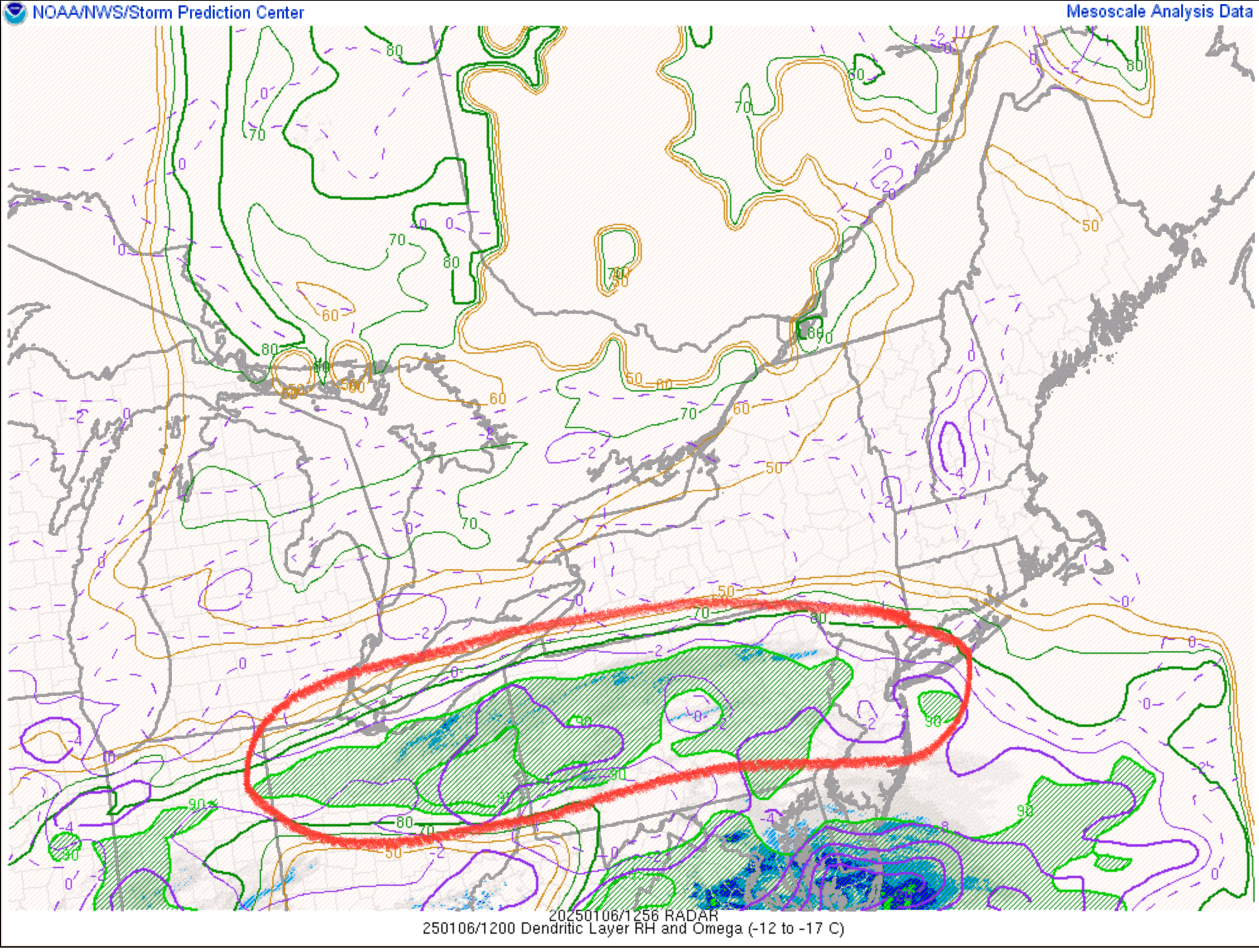
It’s pretty evident that some of the better mid-level forcing is currently residing further north. Best band of snowfall right now appears to be residing all the way up between I-80 and US 6 corridor. Looking at mesoanalysis, this coincides with the area of 700mb frontogenesis and thickest dendritic growth zone layer. This may be the result of the 700mb being further north and more robust + temp advection in that layer.
700mb heights/frontogenesis

DGZ depth
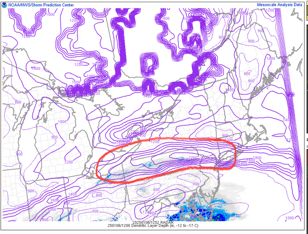
DGZ relative humidity and omega (lift)

-
4
-
3
-
-
Moderate snow here with about an inch so far. 18°F
-
1
-
-
511PA cams showing it snowing at least as far as far NE as the US 219 corridor between Somerset and Meyersdale, so looks mostly on schedule with the onset so far.
Obs here is cloudy and 19ºF/12ºF temp and dewpoint. Nice crisp airmass for a snow event.
-
1
-
-
34 minutes ago, paweather said:
I haven’t been in the MA thread maybe once so far. I am happy for them. They deserve it every once in a while. I’ll take my 3-5” and be happy as well.

It’s likely to be the biggest snowfall DC metro has seen in a number of years, they were 100% overdue for a moderate-heavy event like this.
Whatever happens here I think we can all agree that it’s really nice to hash out the details for an all snow event that hasn’t really had any threat of mixing the last few days anywhere in this subforum.
-
5
-
 4
4
-
-
15 minutes ago, Bubbler86 said:
Not gospel of course but the HRRR would dictate a WSW for basically the entire LSV. Basically a hold from 12Z. Knocked 1-2" off far East and NE locales in the valley.,
This might be one of those situations that their zones would be better with splitting York/Lancaster in half (advisory north warning south). Either way I have a gut feeling those counties eventually get upgraded for a low end 4-6 warning. As was discussed in my post a couple pages back pertaining to the CTP disco, the shortwave over New England that is the possible detriment for more expansive heavier snow further into C-PA is not going to be in the HRRR’s realm until the 0z run later. So that might be most important model run of our lives coming up haha.
-
4
-
2
-


Central PA Winter 2024/2025
in Upstate New York/Pennsylvania
Posted
Safe to say the Canadian is pretty similar to the RGEM.
And in terms of the Lower Sus Valley Kuchera is running near 10:1 with accums.