

MAG5035
-
Posts
5,884 -
Joined
-
Last visited
Content Type
Profiles
Blogs
Forums
American Weather
Media Demo
Store
Gallery
Posts posted by MAG5035
-
-
Had another 0.3” from a squall when I was out cleaning up earlier, so bump the total up to 5.5”. Gauge is melting down now so I’ll see if I can get a ratio. Winds are kicking up.
-
 3
3
-
 1
1
-
-
2 minutes ago, Atomixwx said:
Parents in Orbisonia reporting a foot. I'll be down there this afternoon to verify. I didn't think the lower part of Huntingdon county would have ended up in the death band but what do I know?
Sent from my motorola edge 5G UW (2021) using Tapatalk
It’s possible, that area would’ve been right in line with the bigger totals further east. There were also 10+ totals reported all the way back in eastern Ohio with a stripe of warning totals just below the Pittsburgh metro.
-
42 minutes ago, Bubbler86 said:
Eyeballing about 2" but nothing concrete or road has snow on it. Going to go down (here) as one of the worst WSW events ever. Not the NWS's fault. Modeling pulled the rug. Light snow and 30. Two WSW's in a week and the combined snow from both events is less than 6" @Chris78 any better there? @WaynesboroWX
The Icon Storm. PD3: Pretty Damn Depressing X3. Congrats to Blizz. Did not see any other posts of verifying WSW yet except to the East of this Forum. Maybe Accuchris did. Or the Pillow area.
Last event was my worst, or at least certainly the worst I’ve had anytime recently the way one that busted in the true central and north central. I got close to technically verifying a warning but was within the forecast range of 4-7”. Even up here roads took awhile to get snow covered and they never were super terrible at any point. Road crews were also really on this event as well.
-
5.2” is the final total here. Temp has fallen back to 23.5ºF
My snow forecast looked like it did okay mostly.
Obviously that impressive FGEN band really overachieved in a narrow stripe that carried all the way to the east and to the south in the LSV below Harrisburg it underachieved. I basically expected a general 3-5” and highlighted that dashed area to cover the expected area that narrow band was going to set up somewhere within, so I caught some of it and was a bit south overall and didn’t stretch it enough. And then came up short in a corridor just below the band in the southern tier. Dynamics and temps aloft were as advertised as evidenced by the fluff bomb that ensued within the band but didn’t expect surface temps to be the issue that they ended up being.
Also didn’t realize that LWX had upped their totals to 5-8” in a large swath of their northern CWA yesterday prior to the event starting. That’s a brutal bust for them down there.
-
1
-
-
13 minutes ago, Blizzard of 93 said:
Yes, it was remarkable.
I looked out a few times & it was ripping snow in that band. The fluff factor was high. I needed to go out at this late hour to verify what I thought that I was eyeballing.
I was pleasantly surprised at the 6.5. I have a decent chance to reach 8 with a couple of hours to go even with the lightened up current rate.
There’s been some half decent back building on PBZ radar. Starting to have a more NW-SE component to its movement. Have to see how well that translates over the mountains to the Sus Valley.
-
At about 4.5” here, with light to moderate rate. Temp down to 28ºF
-
1
-
-
17 minutes ago, Blizzard of 93 said:
This band near Harrisburg means business.
i am up to 6.5 of snow in Marysville with moderate snow ongoing at 1:20 am.
Wow, it was about 2 hrs ago or so you posted that you were working on your first inch.
-
10 minutes ago, Jonesy56 said:
It’s delivering the goods about 5 miles NE of Harrisburg.. we just got a special weather statement indicating up to 3”/hour in spots.. I’ve picked up an additional 1.5 since midnight.
.The 511 cams on US 322/22 on both sides of the Duncannon bridge look like they’re getting pounded too, as well as the rest of that stretch down to I-81.
-
Well I dunno where exactly in Harrisburg everyone there lives but it seems like it’s snowing everywhere in/around town there now looking at 511 cams. The 700mb FGEN band is setup overhead as well. This should pile up pretty fast.

-
1
-
-
7 minutes ago, Itstrainingtime said:
I had 5 minutes of flurries an hour ago. That's been it.
Steadier stuff should be working into York/Lancaster here pretty directly by the looks of LWX radar.
-
1
-
-
Just got home here, was out for the evening. Nice event ongoing with 3.5” down and a nice moderately heavy rate currently. 29/28ºF
-
5
-
-
3:40 after nooners. 37º/16ºF light wind and cirrus overcast. Max wind gust of 38mph occurred around 4:30 this morning.
-
1 hour ago, Bubbler86 said:
Unfortunately, Franklin is only 3-6 but that would be fine as well.
My bad haha I didn’t realize they divided up the warnings up that much.
-
1
-
-
Here’s some of the western part of that, CTP went warnings all southern tier and bumped up the advisories in the next tier to warnings. Western southern tier (Bedord/Fulton/Franklin) is 5-7 and Laurels is 6-8.
QuoteURGENT - WINTER WEATHER MESSAGE National Weather Service State College PA 139 PM EST Fri Feb 16 2024 PAZ025>028-170900- /O.UPG.KCTP.WW.Y.0012.240217T0000Z-240217T1200Z/ /O.NEW.KCTP.WS.W.0006.240217T0000Z-240217T1200Z/ Blair-Huntingdon-Mifflin-Juniata- Including the cities of Altoona, Huntingdon, Mount Union, Lewistown, and Mifflintown 139 PM EST Fri Feb 16 2024 ...WINTER STORM WARNING IN EFFECT FROM 7 PM THIS EVENING TO 7 AM EST SATURDAY... * WHAT...Heavy snow expected. Total snow accumulations of 4 to 7 inches. * WHERE...Blair, Huntingdon, Mifflin and Juniata Counties. * WHEN...From 7 PM this evening to 7 AM EST Saturday. * IMPACTS...Travel could be very difficult.
-
2
-
-
11 minutes ago, mahantango#1 said:
From our great friend DT: last call
Looks pretty reasonable. I wonder why his northern fringe goes to infinity at the PA/NY border.
-
 3
3
-
-
46 minutes ago, Atomixwx said:
My point and click is calling for 2-4 inches tonight. HWO posted. I suspect CTP will probably hoist advisories across the board at 2:00.
Sent from my motorola edge 5G UW (2021) using Tapatalk
This is the kind of event our area overachieves on if the good precip and forcing are north enough.
-
1
-
-
1 minute ago, Itstrainingtime said:
I appreciate your dedicated effort to extend the hash just far enough east to include me.
Haha I didn’t know everyone was putting their snow maps out while I was working on my post. The snow map game is strong in here today.
-
1
-
-
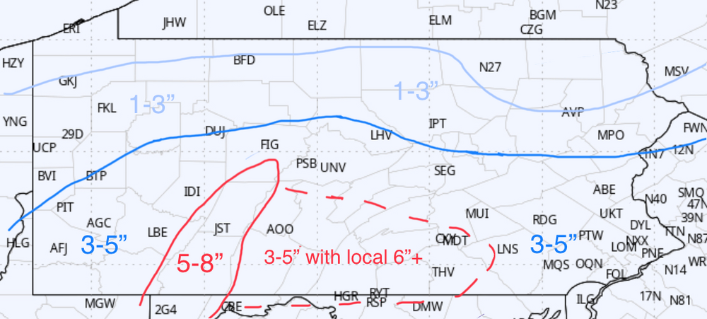
My map for this.

Tried to make a compromise in blends but perhaps on the bolder side. I anticipate CTP needing another tier or so of advisories in the central and upping at least the western half of the watches to warnings. 3-5” amounts should be common in the main swath. Big question is in or near the area I hashed. I was going to get cute and try to highlight two distinct areas but I’d probably need a bigger map. Any rate I feel the hashed area has the best chance to see an embedded swath of 5-6”+ and/or local totals of 6+. Best 700mb forcing is in there coupled with 700mb temps in the low minus teens. The fluff bomb potential is high with that. The southern Laurels will have that plus the benefit of some extra upslope forcing and colder surface temps.. hence the distinct 5-8” I anticipate there. The other snowfall max is probably somewhere in the northern Mid-Atl (northern VA/northern MD, where better 850mb forcing will be. That won’t yield the bigger ratios like the 700mb dynamics that should be residing in southern PA.
-
3
-
3
-
-
29 minutes ago, Bubbler86 said:
My comment was based on the quick changing situation last time and a compare to this time. 36 hours before the event, not many models have me getting 5" or more with the last system yet I had a WSW. Now, there are several models that suggest 5" here and there is nothing from them except a down play of the situation. They could of course be right but it is not consistent with their actions on the last system. We are actually down to 24 hours before the event at this point.
Yea that is true, and they honestly looked really good by the end of Sunday when things shifted south a bit. They upgraded high confidence counties to warnings and kept the watches that reached into the Sus Valley. The big shift south Monday at <24hrs til go time really sent the forecast sideways. Then they never downgraded the warning they had for here last event either when it was abundantly clear AOO-UNV wasn’t getting 6+. Even JB said just prior to the event they needed to get rid of the warnings for the State College area haha. They just turned it into a 2-4” winter storm warning, which I’ve never seen before. Then of course the high confidence counties above I-80 that were originally warned didn’t even see any snow in the end. What happened with the Tuesday event was brutal, and I don’t know if there was much to be done with that kind of a shift in guidance.
I don’t expect anything drastic to happen with this system. Precip shield should have much less of a northern gradient than Tuesday and big thing for our area is determining how much of southern PA to put in advisories IMO. Wagons north seems to be the theme of happy hour so far (need the Euro yet).
-
To be fair, LWX’s watch statement is for most likely outcome of 2-4” with isolated 6” amounts in heavier bands. That’s a bit of a stretch for a region that needs widespread 5” or more to verify a warning, technically. Both ends of the spectrum between CTP and LWX haha.
-
16 minutes ago, Bubbler86 said:
There is more evidence to have a Winter Storm Watch out now than there was for the last storm, IMO. Not only do they not do that they suggest it is too early for a WWA. Local news channels are beating the drum and going with 2-4 or 3-5. I try to stay away from insulting and not going to do it here, but this does seem bad. There are some NWS sympathizers among us, and I appreciate the viewpoint, but this is not great.
Certainly there’s support for the southern Laurel’s to have one. You’d think a coordination with LWX/PBZ having watches in Garrett/Western Alleghany in western MD (LWX) and Eastern Preston in WV (PBZ) would possibly warrant a watch up into Somerset. Those high elevations are probably going to be low-mid 20s during the height of the event. Temps aloft are supportive of a higher ratio event and couple that with some upsloping and I believe some of those short range models are onto something having 6”+ up in those areas. I dunno about watches east of that yet. Like I said a bit ago, probably don’t need to rush the advisories. I’d wait to see 0z and then go from there. I’m surprised there hasn’t been a mention in the HWO about any accumulating snow or prospects of it at all, though.
I dunno, I doubt it but maybe getting burned on models bailing south 100 miles in the 24 hr lead up to Tuesday mornings event made for some cold feet.
-
6 minutes ago, Itstrainingtime said:
Also, Sterling tapers their amounts down south of DC while CTP says the heaviest may be south of DC.
Weird take, the only thing that represents what CTP is talking about in their AFD was the 12z GFS op. Everything else supports advisories in at least the first tier or two of counties in southern PA currently. No need to jump the gun issuing them just yet but I’m not sure what guidance they’re basing the current take on.
Also weird, the snow here has transitioned to graupel
-
2
-
2
-
-
Snowing here now.
-
4
-
-
2 minutes ago, Atomixwx said:
Snow has commenced.
Sent from my motorola edge 5G UW (2021) using Tapatalk
Got dark in a hurry down here. Waiting for the precip to reach the ground. At 39 with a 26ºF dewpoint so probably can manage some flakes out of this.
-
1
-


Central PA Winter 23/24
in Upstate New York/Pennsylvania
Posted
It was pretty legit, I was out running errands whenever it arrived. I thought boy this could probably use a snow squall warning and I checked my phone and there was one already issued haha.
Fresh wind driven coating and high gust of about 30mph. Despite all that and the temperature going from 28 to less than 22ºF at the height of the squall, no caving of any asphalt surface.