

MAG5035
-
Posts
5,884 -
Joined
-
Last visited
Content Type
Profiles
Blogs
Forums
American Weather
Media Demo
Store
Gallery
Posts posted by MAG5035
-
-
The SE breeze here this afternoon is definitely more feisty than the one with Tuesday’s system. High gust of 31mph. Temp/dewpoint at 40/28ºF.
-
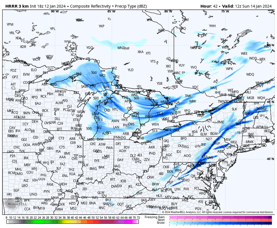
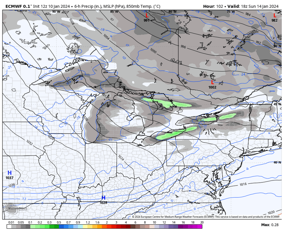
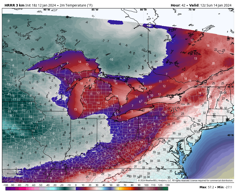
Extended 18z HRRR is interesting toward the end. Occluded front comes through overnight tonight and brings falling temps back to around freezing tomorrow. There’s the arctic front that then comes through Sat night-Sun morning that sharply brings temps down with the arrival of the actual arctic air. Tries to model a line of squalls crossing the state with it. Perhaps something to keep an eye on this weekend. This feature is showing on other high res guidance like the 3k NAM and RRFS.
-
 3
3
-
 1
1
-
-
12z vs 6z GEFS on the means, pretty notable step back this run
I think a more progressive outcome is still workable (and perhaps the most likely outcome currently) as the 500mb energy diving in behind the developing coastal low probably still helps generate the shield of precip thats been on the GFS and Canadian. It wouldn’t a be a big hitter for us but a light to moderate event with a cold column can make up some in ratios. Need to get the Euro on board to at least some degree at some point.
-
1
-
-
1 hour ago, Itstrainingtime said:
@MAG5035 - the potential heavy snowfall rates in Orchard Park will be just one element - BUF forecasting winds Sunday afternoon at 25-30mph sustained with gusts in the 40s. It's going to be very difficult to execute pretty much anything on offense.
Not to mention Saturday night having 65mph wind gusts. Man I don’t know haha, BUF grids around there have 8-12 by Sunday morning and it looks like the main band focuses there in the morning right up to game time on high res guidance before maybe it slides just south. That’s going to be really difficult for fans to get to day of. Being a playoff game, not much you can do. I’m sure they wouldn’t move venues. About the only thing you could do is push the game to Monday.. and there’s still heavy snow in the grids that day too.
PFT finally had an article about it this morning.
Quote“We are monitoring conditions as we do for every game, but there have been no discussionsabout making a change to the game’s status,” NFL spokesman Brian McCarthy told WGRZ.com.
The current forecast doesn’t call for significant snow on game day, but there is a winter storm watch. Wind could also be an issue on Sunday
I don’t know where Florio is getting his weather forecast but it certainly isn’t the NWS.
-
1
-
-
1 hour ago, Bubbler86 said:
About a 1/4 of PA, including Magland, still has potential snow on the way for rush hour today. What is rush hour like in the Laurels? LOL
Busier than you think haha. The major routes around here (I-99, US 22, US 322, US 219) are moderately busy, especially around State College. The stretch of Route 322 that goes up the Allegheny Front towards Clearfield was closed for several hours during Tuesday morning’s snow blast, as were several other intermediate routes in the area. I’m looking north of here for any potential bigger issues this evening, though we’ll see. North-central up above I-80 has been the target area for several inches of snow. Between here and State College on the I-99 corridor will be need to be watched when precip arrives this eve, but this one will be starting with warmer surface temps.
-
1
-
-
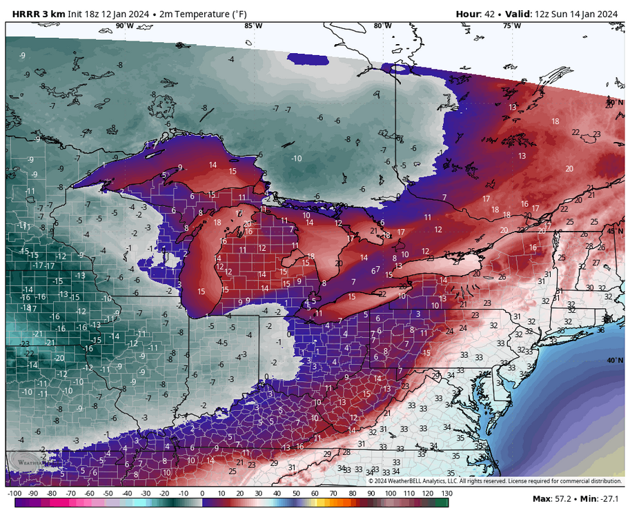
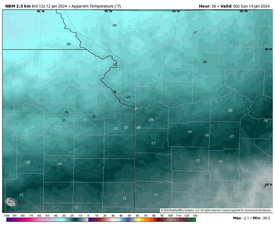
Here’s the latest for the arctic wild-card matchups
Kansas City 7pm Sat via NBM. This falls to about -3ºF by the end of the game. Euro is as cold as -5ºF at kickoff

Wind Chills:
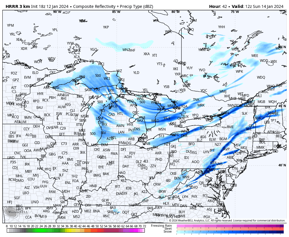
Here’s BUF’s early snow forecast for the lake effect snow. Orchard Park is right in the middle of that 18-24”

-
1
-
2
-
-
3 hours ago, MillvilleWx said:
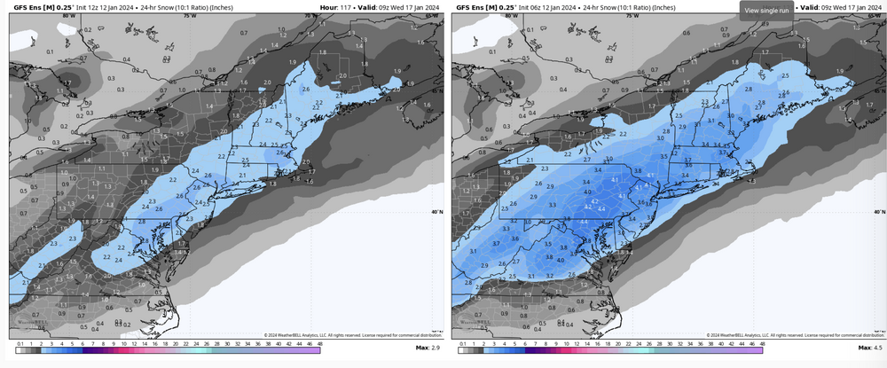
Hey guys! Popping in to provide some thoughts. Yesterday I liked the trends, outside the Euro which is currently on its own with regards to the 5H pattern. I mentioned in the MA thread yesterday about suppression or no storm concerns given the chaotic upper level vorticity pattern across the NH. This storm currently developing across the mid-section will help set the stage in a multitude of ways for what could occur next week. One of the things I like is the multiple ways to score in this event, whether that be a marginal event or a SECS/MECS if all breaks the right way and we induce phasing at the right time.
Until we get a full resolve for what occurs with this current system, it will be a feedback mechanism for the medium range. I do love seeing increased ensemble support and the blend either maintaining a solid depiction of areal snow coverage of 2-3+”, and/or improving in the means and median of potential outcomes. Still got time to see some significant shifts within the surface evolution, but I say by Sunday we’ll have a general idea and all systems would be go if everything is in-sync. LSV and points northeast are the primary for this pattern, but the central and west-central folks could certainly get in on the action with high-ratio fluff in the right evolution. Fun times!
")
What do you think about the 500mb differences out west? To me that’s part of the equation of why the Euro is doing what it’s doing having a potent shortwave swinging down into the Pac NW dampening the western ridge where the GFS just has a nicely amplified ridge all the way up thru BC and no shortwave whatsoever. On the other hand I guess other guidance like the Canadian has that shortwave feature similar to the Euro and manages to be even further inside with the track than the GFS. But putting the Euro and GFS side by side that’s a big difference in the major features out west.

-
18z Euro ensemble mean/probs were in the ballpark of how it was 12z (a tad better in PA with 1”+ probs, while the Euro control at least had a system of some substance this go around with a wave of light snow thru PA and a swath of 2”+ I-95 corridor and east.
-
1
-
-
The 500mb differences in the Euro v GFS today were massive, not only in the timeframe of the Tues event but beyond it.
I’m using 12z so i can do the Euro v GFS side by side (18z GFS was similar to 12z)


GFS has a much more defined western ridge axis that extends all the way up thru BC while the Euro has a shortwave diving into Washington really dampening the ridge. The more amplified GFS allows the shortwave trough axis to rotate and generate our east coast storm. We’re going to have to continue to resolve thru the handling of these features, but certainly a sizeable event is on the table. If we amplify similar to the GFS I will note the position of the western ridge axis on the west coast. C-PA ideal positioning is the ridge axis thru Boise, ID… so it’s a little bit west. Given the cold on the playing field I think this is still okay but if we amplify a bigger event I don’t think we’d be fringed.
-
2
-
-
Some finals from yesterday’s storm. 1.47” total as measured by the rain gauge (WS-5000 station), which includes morning snow that piled into it. I brought the rain gauge inside and got the snow quickly melted. That only yielded about 0.4” which is likely too low, that would’ve been a 17.5:1 ratio at 7”. Ratio was probably close to 10:1, so precip total with the inch of rain was probably more in the 1.75” range.
Pressure bottomed out at 983mb around 9pm last night, a drop of 41mb in 24 hours.
Peak wind gust (this afternoon) of 42 mph. It was pretty windy today but nothing crazy despite the early morning upgrade to high wind warning this county had today.
Still generally 6” of snow in the yard, except under the pine trees at the edge of the property. There was about 3-4” of snow left from Saturday prior to yesterdays snow.
-
3
-
-
4 minutes ago, canderson said:
The Buffalo game might be fun with lake effect snow. Not sure timing there.
I’d make a solid wager on it becoming very newsworthy in the sports media as it gets in the short range and BUF starts putting out products and accumulation forecasts for it (significant LES already being mentioned in their AFD). Although I’d probably make a solid wager on taking the Steelers at +10 too haha.
But it seriously looks like a great setup for a major LES event. It’d be the first widespread one of the season with legitimate cold air over the unfrozen lakes too. I posted a map a few days ago and things look about the same with that WSW flow over the length of Lake Erie focusing on the south towns of Buffalo (where Orchard Park is). Aligned cyclonic WSW flow all the way up through 700mb. Low level 925 and 850mb temps in the -10 to -18ºC (ideal range for snow growth) over water temps in Erie that are mostly in the upper 30s to near 40. Timing is right around game time too and during Sunday. It could be a quite a spectacle.
-
2
-
1
-
-
17 minutes ago, Bubbler86 said:
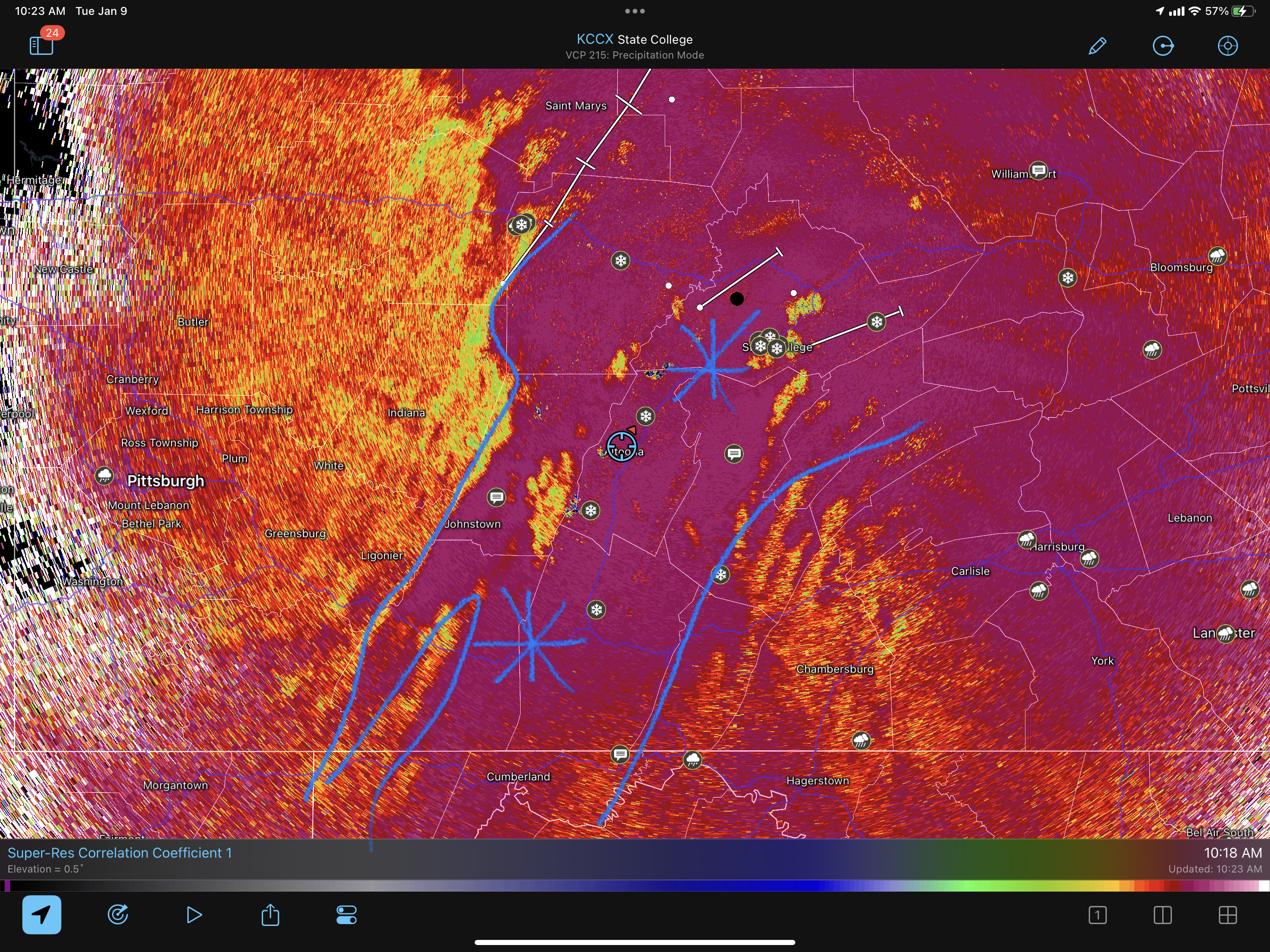
If the 5 min views are to be believe, the highest gust at MDT today is only 32. 38 at LNS. Still 54 here with over 10 50+ gusts now affirmed by another rig in the neighborhood.
You might be getting some local downsloping off whichever ridge is just east of Rouzerville (not familiar with the names down there). Velocities in that orange are 80+ mph and beam height around where you’re at is at about 4k feet (about the 900mb level). Which by the way, using LWX here but I haven’t seen that kind of velocity presentation on CCX radar since Sandy.

-
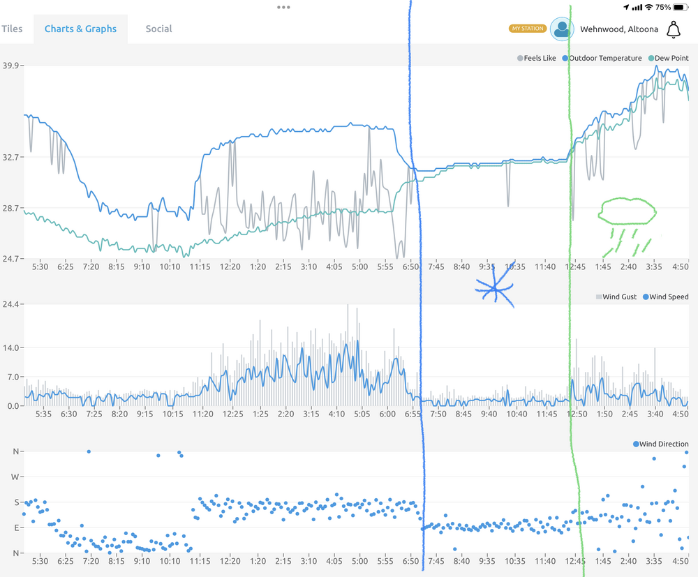
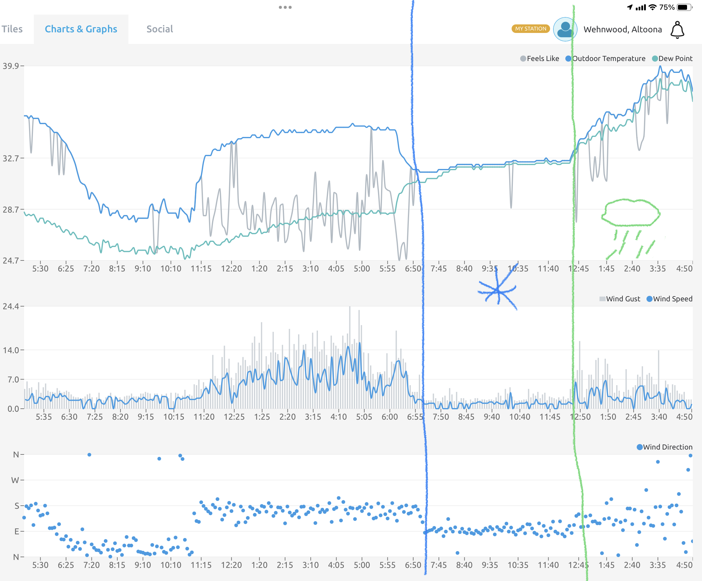
There’s been very little wind here all day. The snowpack has helped with keeping a stable cool surface layer. Peak wind gust on my station was 24.4mph which happened pre-dawn before the precip arrived. Only some mid-teens gusts occasionally this afternoon.
Precip onset and changeover points are easily noticeable on the weather station obs with the wind direction changes and the temp/dew. Not to mention you can see the first half of last night where there was rad cooling and the temps spiked above freezing when the wind kicked up out of the south.
-
3
-
-
Finally gave up the good fight in the last half hour. Transition to rain at 33/33ºF. Final snow total was 7”.
-
3
-
-
8 minutes ago, skiier04 said:
Wow surprised you're still holding on and impressive totals! Seems like some rain mixing in with some lighter rates here now. But that was a fun one. Heavier snow this morning than I saw anytime on Saturday. Eyeballing about 3" imby
Yea this is a really unique setup, CTP had noted a lot of mixing at the office there in State College. It’s almost like a valley to valley difference. I briefly had mixing when I made that report at 915am, figured that was going to be it. Then it went back to snow and it resumed piling up. The CC product is starting to close in now, so it won’t be long. I actually am just starting to hear some pings.
-
2 minutes ago, skiier04 said:
Fun AFD from CTP this morning
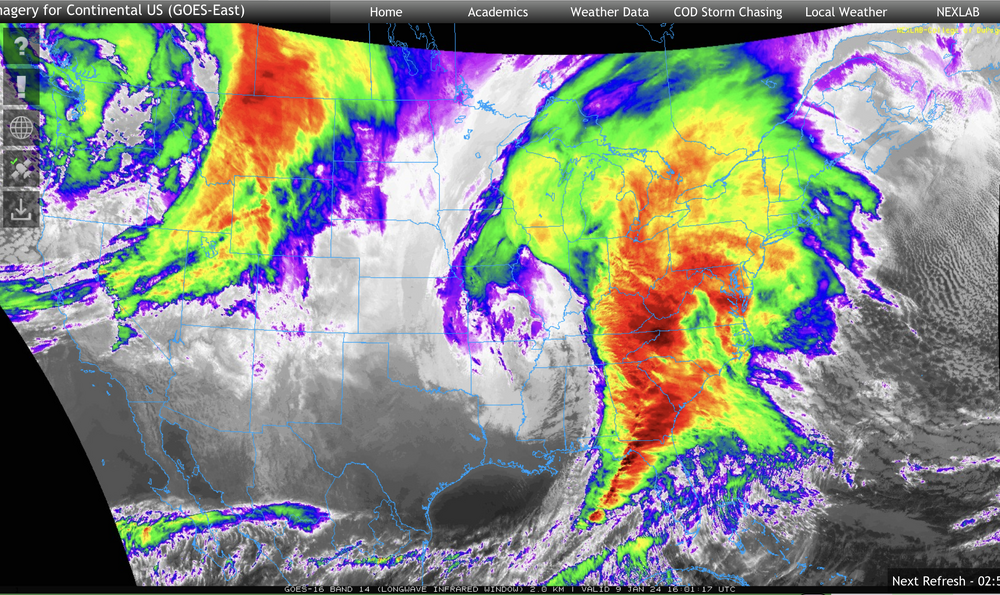
.NEAR TERM /THROUGH TONIGHT/...
Yesterday`s signal for a front end snow thump has materialized
with areas from the Laurels through the WC and C Mountains
having seen a quick 2 to 5 inch accumulation this morning.
Dramatic snowfall rates and reflectivities have accompanied
the heavy snow, with some of the largest aggregates I`ve seen
occasionally tripping DP hydrometeor hail classifiction.

The warm air is on the move and messy mix to to sleet and rain
is occurring from south to north, slowest over the Laurel
Highlands and WC Mountains. Here at Innovation Park southeast of
campus, we have repeatedly gone from heavy snow to mixed sleet
and rain and back again several times. Strong forcing will keep
this back and forth transition going through midday, with
additional coatings of high SLR slush across the central and
south. Best additional snow accumulations will be north of I-80
with again a general 2 to 5 inches expected before the warm air
wins by late afternoon.

9:15 AM: 4.3 inches measured at Penn State Altoona and a 5.4"
from our Glencoe observer from this morning`s burst of heavy
snowfall. Transition to sleet and rain occurring central and
south with minimal additional snow accumulations south of I-80,
but we`ll see similar 2 to 4 inch amounts up to parts of McKean
and Potter through the midday hours. No additional updates at
this time.

805 AM: Doubled snow amounts into the central mountains
as 1.5-2" per hour rates are lifting across the area. KCCX
WSR-88D sampling of aggregates bumped hydrometeor classification
into hail, a first that I`ve seen. In the bizarre category, a
large flock of starlings simultaneously flew over our office at
Innovation Park (between State College and UNV). Very possible
that this large biological target was being sampled along with
the heavy snow. A general 2 to 5" range is now being mentioned
for the Winter Weather Advisory, which we`ve expanded to include
Elk, Cameron, Potter, McKean and Clinton Counties
That 4.3” report at 915am was from me, and I reported 6” to them when i reached it a little while ago. That is a pretty wild disco with the CCX radar, likely a result of the record anomalous moisture influx from the Gulf.
What a presentation on satellite
-
2
-
-
Between 6.5-7” now, heavy rates. 32/32ºF
-
3
-
1
-
-
5 minutes ago, dj3 said:
My in laws in Johnstown are saying they have around 7 inches new. Sounds like this was pretty unexpected up that way? Either way nice to see some central PA brethren cash in. Slushy mess down in Pittsburgh early this AM but been all rain since 8 or so.
A couple inches were expected even up that way but definitely nothing like this. The Cresson Summit and Gallitzen 511 cameras look nuts right now.
-
1
-
-
4 minutes ago, Itstrainingtime said:
That's awesome! Averaging 1.5"/hour rates for 4 consecutive hours - great stuff right there.
This is easily the best snowstorm I’ve ever seen come from a straight cutter. Blue Knob Ski Resort claims a foot has fallen up there this morning.

-
4
-
-
-
At 6”, with heavy snow and 32/32ºF. I think there’s been some compacting too with the marginal temps. This event started around 630am here, what a beat down.
Roads have been a mess, haven’t heard too many bad accidents on the scanner but lots of stuck cars.
-
2
-
-
12 minutes ago, Bubbler86 said:
I basically paid no attention to this as to snow but did see some models, I think the RGEM was one, showing several inches of snow to my west.
Some of the high res models were showing 10”+ on the top of the Allegheny front just west of here yesterday, which I thought was way over done. But maybe not given how hard it’s been snowing down here.
-
2
-
-
A look at 511pa cams in the Laurels still shows mostly snow on the cams in Somerset Co all the way down to Meyersdale and the cam on the Somerset/Westmoreland line. Mixing or rain on those cams are usually a sign of such things here soon, so probably have some time yet here. I’m at about 5” now so it’s becoming very likely I’m going to verify a warning out of this.
13 minutes ago, Bubbler86 said:Just saw on the MA that parts of Frederick county MD have 1-2" of snow now and route 81 is closed? Also schools closing or closed. This is a Blizz type of cutter.
It’s funny how all this works after Saturday’s storm haha. I wonder if the high pressure to the north was underestimated, even with the HRRR.
-
Just now, Bubbler86 said:
You may need the National Guard for the enxt one which is looking slightly colder.
The next one doesn’t have much of a high progged to the north like this one actually does. 1035ish N of Maine vs the very deep low approaching. If you guys flipped over to snow I wonder if the rest of the Sus Valley can get a period of snow as the heavier precip moves up into there.
-
1
-


Central PA Winter 23/24
in Upstate New York/Pennsylvania
Posted
I didn’t notice the Mid-Atlantic folks started a storm thread earlier this afternoon, that explains everything haha.