

MAG5035
-
Posts
5,718 -
Joined
-
Last visited
Content Type
Profiles
Blogs
Forums
American Weather
Media Demo
Store
Gallery
Posts posted by MAG5035
-
-
At 1.06” for the rainfall for today with this event. Temp is all the way up near 56ºF right now which I’m sure is +30-35ºF for this time of the year here. It’s gonna take a cold rest of the month and/or one heck of an arctic outbreak to even out the + departures we’ll have accrued this first week of January by the time temps come back down to normal-ish late in the week.
-
 1
1
-
-
MJO has been a fairly big driver in the turnaround to warm the last several days and looks to potentially remain a factor as we get later into the month.
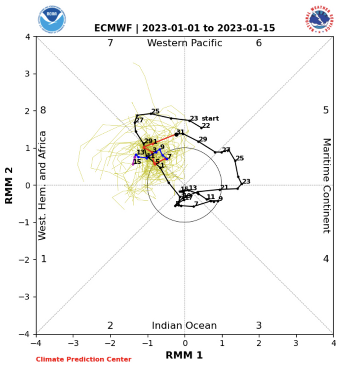
You can see that it entered Phase 4/5 by Dec 22, right when the arctic blast crashed through us… and has spent the last week cycling 5 and 6. Now this teleconnection isn’t instantaneous, but when you consider how strongly correlated to eastern warmth 4-6 are during the winter months.. you can see why our cold snap was cut short when it could have lingered longer without this major reshuffle in the pattern.
So we’re already into Phase 7 technically, which is a “better” phase… and the pattern responds as such after the Tuesday cutter as we get some Canadian ridging above and knock down the SE ridge.. allowing an attempt at perhaps a more favorable storm track and temps that could still be an issue.. but still doable for snow for us in the right setup. It seems the Jan 6-8 timeframe could present something either in the form of some kind of inverted trough feature with the lingering upper low from the midweek system or maybe a whole other system a couple days later. Hasn’t been much consistency yet on either feature.
MJO forecasts going forward suggest an attempt at getting into phase 8 and maybe 1 and 2 depending on the forecast. I put up the Euro and ensembles for this post, which shows a sluggish move into 8 (GEFS similar) but the extended (monthly) Euro shows a more consise 8-1-2 run as we get from about mid month on. That would be ideal to help set up an eventual return of a widespread below average temp regime to the eastern US, something the ensembles seem to be introducing currently esp beyond D10. In the meantime, we maintain a half decent setup for undercutting storms with higher heights over Canada.. but the potential will get better in time temp wise if/when we get some better support in the Pacific realm (EPO). Right now we’re not really looking at true cold in the pattern initially even with a better looking storm track on our side of the country and a continued mostly -AO. That’s due to the low heights and suppressed jet in the northern Pac keeping an active pattern into the western states, not to mention the aforementioned above normal heights in Canada correlate to significantly above normal temps for that region as well. Once we build some western ridging and ideally reverse the EPO back to negative, we should tap back into a much colder air source.
Whether or not the MJO does a full blown 8-1-2 run, I’m kind of glad the MJO has gotten this 4-5-6 run out of the way and didn’t stall in those phases in the process. As long as it stays out of there, we’ll have a chance to deliver a favorable pattern for cold and snow. And it appears barring any major changes the next couple weeks that we’ll likely stay out of it for at least most of January. Otherwise, you couple that 4-5-6 with the moderate Nina base state at any point in the next 1.5-2 months and it’ll be more of the kind of weather we’re seeing right now.
-
6
-
 1
1
-
 1
1
-
-
51ºF here, the first such day (50+) in the last 22 days. Definitely some melting but yard still maintaining pretty much full coverage in terms of the pack, for now.
-
Merry Christmas everyone!
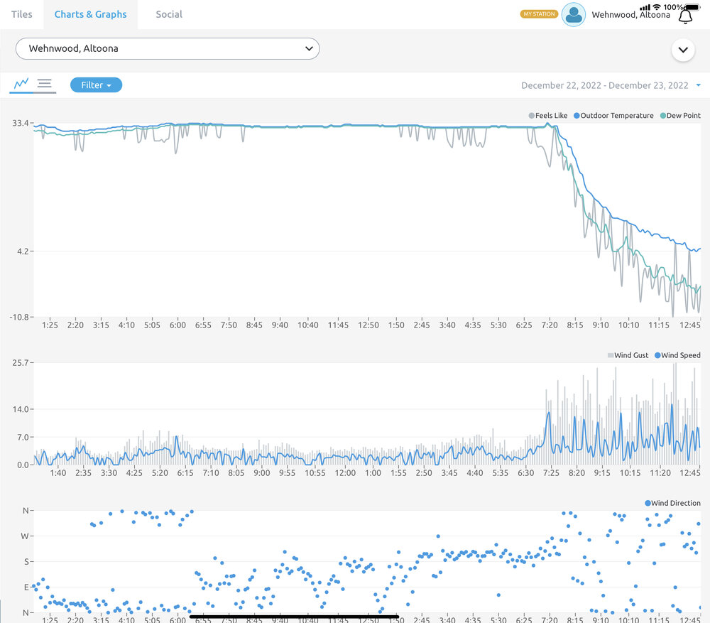
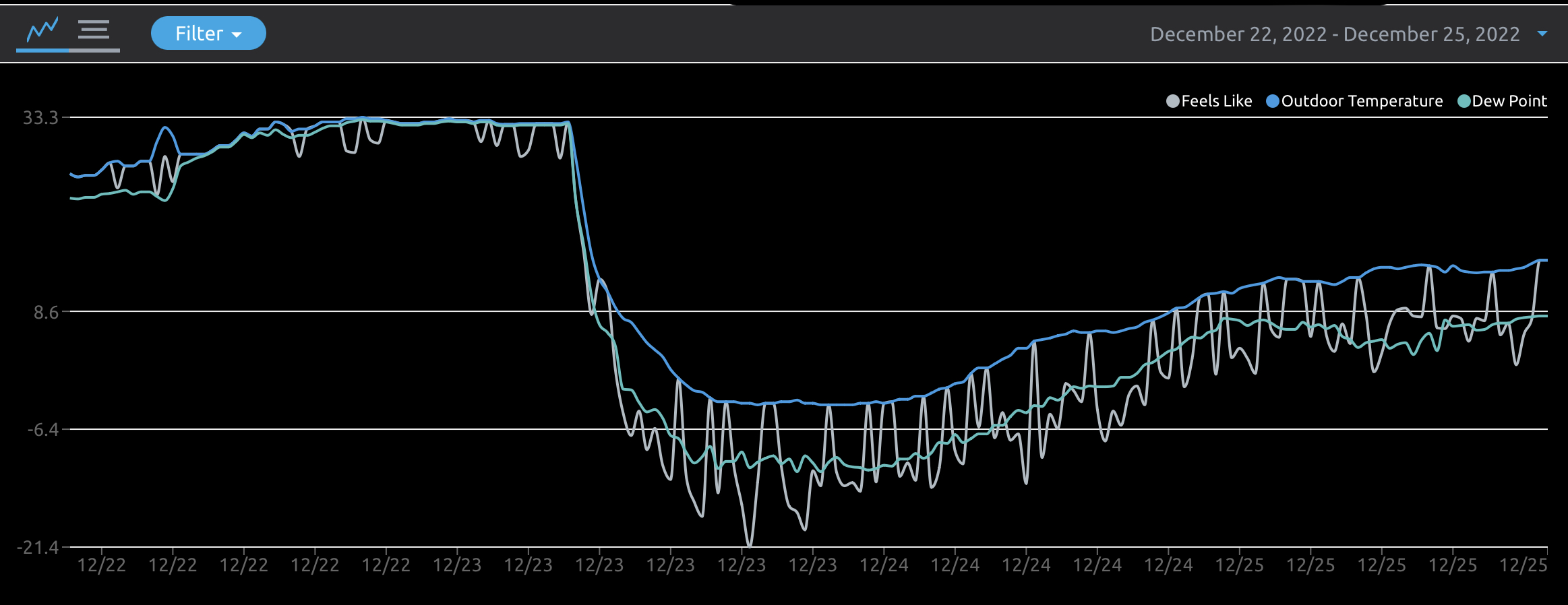
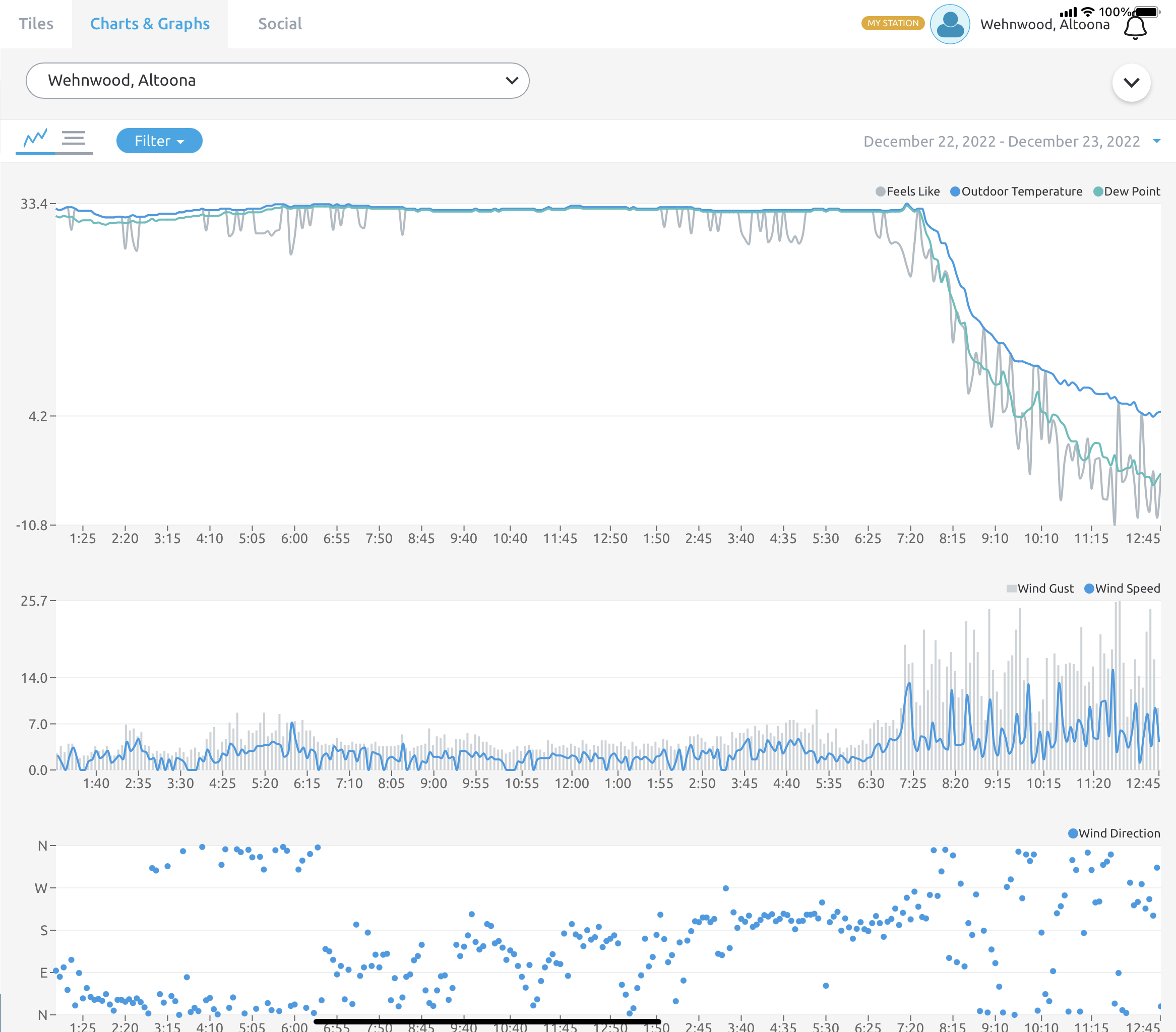
Temp has reached a balmy 15.1ºF, still a pretty stiff breeze. This arctic air mass has definitely been something else. TIme of the year (min sun angle) has a part in it but since the air mass arrived Friday Morning temperature trends have been completely non-diurnal. Christmas Eve here had a -3.5ºF low and a high of 10.8ºF, which was reached right at midnight last night. Mean temp yesterday was 2.5ºF, averaged from obs every min. Today had pretty steady temps with a low of 10.8 and high 15.3ºF.
As mentioned yesterday, we spent about 18 hrs straight being below zero which covered max daytime heating hours Friday. And consecutive single digit temps ranged from about 1030am Fri til 1130pm last night (37 straight hours). That’s some pretty impressive stuff, it can get cold around here and obviously much colder in radiational cooling situations but you don’t see that kind of cold very often directly associated from the air mass.
Temp/Dew/Apparent graph Dec 22 to Current

-
4
-
-
Low was -3.5ºF last night and just now getting above zero degrees. That made for an 18hr period that it was below zero here.. which is pretty impressive.
-
2
-
-
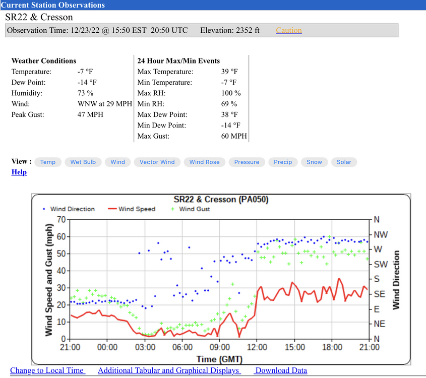
JST, which is at -8ºF currently, had a wind gust to 60mph at some point in the last hour. Current ob (about 10 min ago) is sustained wind of 35 and G44. Thats a -38ºF wind chill when applying just the sustained wind. I mean I can’t think of another arctic shot off the top of my head that combined actual temps of that caliber with such high winds.
-
2
-
-
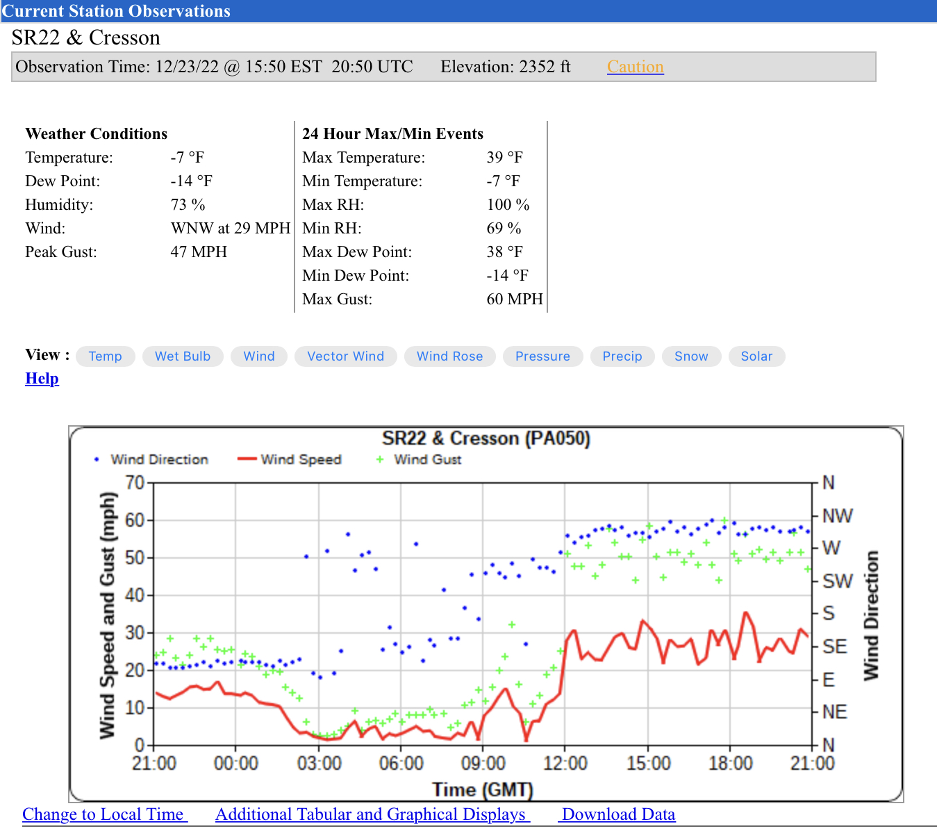
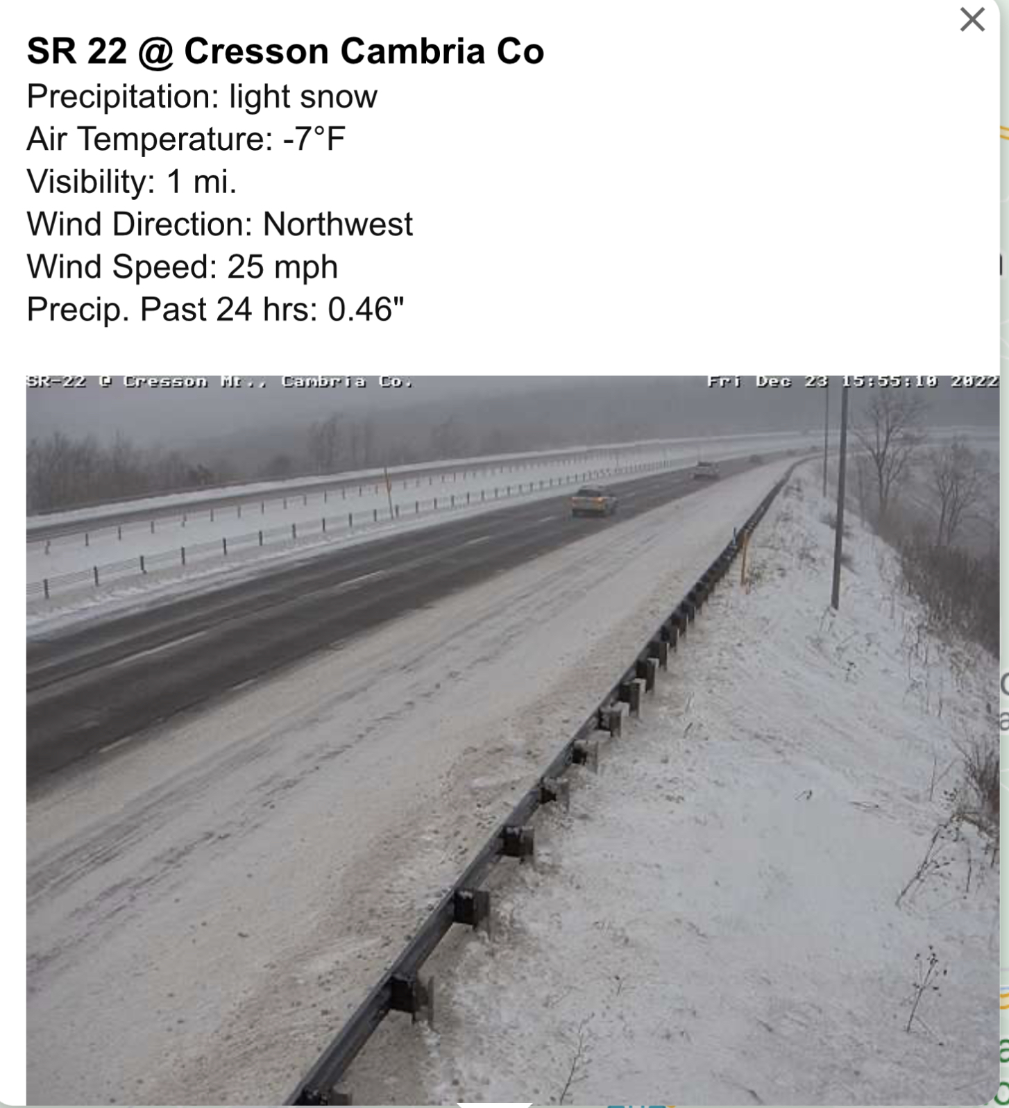
PennDOT RWIS station on Cresson Summit on US 22 just west of Altoona. Max gust of 60mph, consistent gusting near 50mph. Ouch.

-
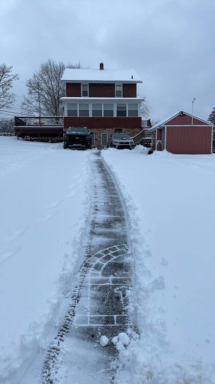
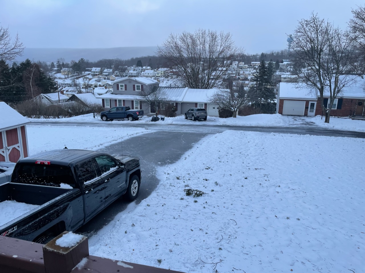
State of the snowpack as promised, you can also see it’s been windy here today with all the pine tree debris. Going outside to take this picture took my breath away.

-
5
-
-
Officially below zero now here, at -1.5ºF with a -10.7ºF dewpoint.
-
1
-
-
2 hours ago, Blizzard of 93 said:
The models are slowly coming around to the idea of a light possible event on the 27th.
Yea that’s the feature that the likes of JB have been calling the “rear guard action” trying to drum up an east coast snow as the pattern shifts and the increasing heights/warm up presses into the Northeast as the EPO flips. There is in fact a half decent 500mb shortwave in that flow dropping down while we’re still in the very late stages of hanging on to the overall eastern CONUS trough, but feature looks postively tilted and stays unphased/progressive. I mean it’s too bad the western pattern will be shifting at that point instead of holding/building a ridge allowing better amplification because boy there would have been a big time phasing opportunity with that.
But as it is, I don’t think it’ll be anything big BUT I could get on board with enough amp to generate an area of light WAA snows in PA that the models may eventually see better in the shorter range the next couple days. It would be warmer than this weekend of course but still fairly cold (def below avg) at that point as well. Even if it ends up being nothing or not much, it probably buys us an extra day or so of colder weather before the more significant warming trend.
-
1
-
-
24 minutes ago, Bubbler86 said:
It is crazy.....we sometimes talk about the lack of snowstorms and sometimes blame it on no cold air but this is right up there with some of the coldest we were will face. I bet someone on this board gets a -10 tonight and someone in or near the LSV gets a -5.
Certainly the Laurel’s are heading that way for a -10 reading. There’s already a couple Mesowest stations near the 7 Springs resort that are -7ºF. I originally thought the HRRR was too cold but it’s actually looking pretty close with its temps so far. The other 12z models seem to be running about 3-5 degrees too warm in western PA at this point of the day, so that will be interesting to see. The 18z HRRR gets JST down to -13ºF tonight and gets a good portion of the LSV at least a touch below zero. NWS grids have -7ºF here for a low tonight now.
It’s a legitimate dangerous situation with the wind chills. Normally temps this low come via a combo of calm air, radiational cooling, and snowpack. These temps are coming with 45-55 mph wind gusts.
-
2
-
-
2 minutes ago, Bubbler86 said:
Harrisburg and West under 20 now (and some east but not all). Down to 10 here.
I think it’s amazing that KPIT (Pittsburgh International) is -4ºF in the middle of the afternoon on Dec 23rd. I’m about to go below zero here. 0.1ºF lol.
-
9
-
-
21 minutes ago, Itstrainingtime said:
Down to 18.8 here. A little brisk - definitely a sweatshirt kind of afternoon out there.
Might need to cycle the AC to take the edge off lol.
-
 2
2
-
-
A somewhat brisk 4.3ºF currently lol. So far peak wind gust measured has been 37 mph. Wasn’t much snow with the front, maybe a dusting. There is some light snow blowing around right now.
Find the FROPA:
Some other noteworthy things… I bottomed out at 984mb at the time of the front passage and the temp for the whole event yesterday never got above 33.4ºF at any point despite the monsoon last night. I’m pretty sure Altoona set both its daily rainfall (CTP noted 1.48” as a new daily max in its climo section ) and possibly daily snowfall record as well. Our local TV met said Altoona measured 5.2” besting the daily record of 3” set in 1926. Not sure sure what part of town that was, I didn’t have quite that much here (3.7”). CTP’s PNS yesterday did have several 5-6” amounts reported, esp towards UNV.
-
3
-
-
Probably unpopular opinion but.. I would rather have what’s coming tomorrow over this currently torrential rain and 33 degrees into a waterlogged snowpack.
Is this what it’s like doing winter in the 95 corridor? Lol
-
1
-
1
-
1
-
-
1 hour ago, canderson said:
Hmmm I saw it on the MA forum - maybe I misread? Sorry!
No problem haha, I was looking to see if you meant the NAM or the GFS when you said that. At any rate even just a half inch to an inch with the rapid temp drops and winds is going to need to be seriously considered for flash freezes and issues on the interstates if one is travelling tomorrow morning.
I think CTP probably should have hung on to advisories back here this evening for freezing rain. Lot of accidents and 911 chatter of iced up roads, especially on the roads going up the Allegheny Front…but some of the other local mountain roads as well. Temp here at home is just a hair above freezing at 33ºF.
Edit to add, I do have some refreezing of my driveway going on despite salting it earlier.
-
2
-
-
12 minutes ago, canderson said:
18z Euro gives MDT 4-5” anafrontal snow tmrw. When did it decide to go all in on being the snowiest model?
Is the 18z Euro even out yet? I don’t see any guidance suggesting that at the moment.
-
1
-
-
Moderate rain and 32.5ºF, I got drenched finishing up snow blowing and shoveling.
Here was the first tracks snow pic from a little while ago. I’ll have a follow up tomorrow morning on the pack after the Day After Tomorrow promptly arrives at 12z.
-
6
-
-
Precip has switched to light rain here, temp still just shy of 32ºF. Gonna call 3.7” as the snow total. C’mon dry slot haha.
-
1
-
-
The changeover is trying, under these yellows and oranges in the radar currently and had fast falling rimed fatties and probably some pingers in there too… now going back to heavier snow again. Temp back down below freezing (31.6ºF).
-
2
-
-
Still hanging onto light snow here, even as surface temps have creeped up to about 33ºF for now. Waves of snow have been sporadic the last couple hours so haven’t added much (just measured 3.6”). Eyeing a heavier band coming up from Bedford and a look at the 511 cams there (and at Breezewood) is showing it snowing all the way down to there yet and actually starting to cave the roads a bit again there. So will see what happens, the HRRR hangs on to snow and/or mixed through about 4-5pm here now.. and the more QPF that ends up frozen the better.
Was glad to see that some of the LSV overachieved this morning and some of the colder solutions had some merit for a change. I thought Harrisburg could get 1-2” when I posted very early this morning, so nice to see some overachieving.
-
4
-
-
A nice burst of snow currently. Up to 3.4” here so far and 30.6ºF temp.
-
Early obs, temp just shy of 28ºF with 24ºF dewpoint. That’s up a couple degrees from being down as low as 26ºF earlier in the evening.
CTP has expanded the winter weather advisory to the west bank of the Susquehanna (for 1-3” in the new counties), and also hoisted high wind watches in the NW and Laurels zones + Bedford/Blair in the I-99 corridor for 50-60 mph gusts and expanded the wind chill watch off the Laurels to also include Southern Centre (UNV), Blair (AOO), Huntingdon and Fulton counties. Like I said earlier, I anticipate wind chill advisories to be eventually hoisted for the rest of the area.
Gonna be a wild 48hrs of observing here. Advisory for 2-4”, Wind chill watch for down to -30ºF wind chills, and high wind watch for 50-60mph gusts. I don’t recall seeing wind chill headlines like that here even during the cold shots of 13/14 and 14/15. The watch portion in the Laurels is for -35ºF chills.
-
1
-
-
Switching gears to the post front phase of this storm, really concerned about the combo of the cold and wind. I mentioned this earlier today but I’m going to illustrate.

With the position of the very deep low, the westerly flow transports the arctic air from the north-central states underneath the lakes, meaning the unfrozen lakes aren’t going to modify the air via a NW flow like if this had been say.. a major coastal low lifting up the coast. It obviously does no good for much snow anywhere in C-PA once past whatever ends up right behind the actual front and maybe some lighter upslope type stuff in the Laurels. It sure will for western NY though, where BUF south probably sees x number of feet of snow again to go with their 40-60mph winds.
At any rate, I really don’t think this is a situation where the cold “modifies” as it gets closer to the time it arrives. On the contrary, I think this is a situation that may be underestimated a bit. I used the 3k NAM for illustration, which is plenty cold showing temps getting below zero in the Laurels/NW PA. That’s also not the coldest frame as by 12z Sat, KAOO and UNV are also below zero with MDT around 5 or so. That’s where the wind has to be considered. I’m still not sure LSV sees crazy winds from this but you combine those temps with even 35-45mph gusts and you easily have wind chill advisory criteria in the whole Sus Valley.
Here’s the 3k’s wind chills at 12z Sat morning:
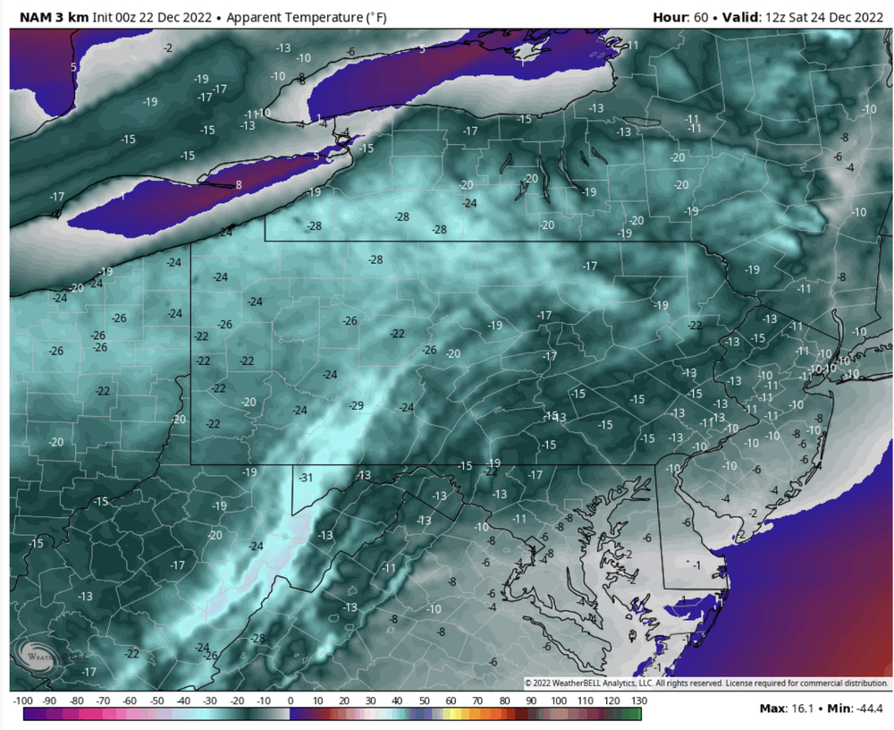
And since I mentioned about my worry that the HRRR might be too cold with the front end precip tomorrow, I might as well also mention that the last full HRRR run back at 0z was much colder than even this 3k NAM, having JST at -11ºF, -8 & -6 at AOO and UNV respectively and near 0 temps all the way to H-burg at the end of its range which is only 0z Sat. That is while having 50-60 mph wind gusts in the Laurels/immediately adjacent central with 35-40mph elsewhere at that point. So with all that, wind chills are practically off the charts for this region (nearly -40ºF in the Laurels) and -15 to -20ºF in MDT. I’d say thats probably a bit over the top, but either way I still believe the wind chill watch areas should go to warnings pretty easily, with the rest of the area seeing advisories.
To put things simply, Friday night into the first half of Christmas Eve is going to be brutal until the wind starts settling down.
-
2
-
1
-


Central PA Winter 2022/2023
in Upstate New York/Pennsylvania
Posted
As far as sensible weather, the only storm threat I’m really going to detail at much length currently is the system slated near that Sun/Mon timeframe. Looks to be a quick system that could deliver a broad area of light to perhaps moderate precip. Should note this has mainly been a GFS/Canadian thing as the Euro has not really shown much of a system or associated organized precip. To that point, the former have a bit of a stronger shortwave. 18z GFS tracked features a bit north of the 12z Canadian, thus showing more of a mixed bag and less snow for C-PA. Thats gonna be important because we don’t have much cold to work with. There’s some Canadian high involved but it’s quickly moving as well. Pretty much, if the weak surface low tracks south enough it should be just enough for a snow event.
Going forward, I do see the potential late next week as we briefly amplify an eastern trough. Def would be looking for a coastal in that timeframe (D7-10) but I don’t like the ridge positioning in the central US and a western trough pressing. To me.. it honestly looks like that specific kind of window of opportunity for the folks further down the eastern seaboard to have better odds of seeing the first actual coastal snow event of the season than it does for us in a pattern that’s…workable.. but by no means ideal. Just my initial thoughts on it, there’s a lot of time to go.
Still trying to make heads or tails of the longer term pattern.. and the models probably are too honestly. Really not liking the persistent (and strengthening) +EPO/WPO the models have been advertising though. What makes this work, at least for the next 6-10 days is the broad Canadian ridging centered near Hudson Bay. These strong systems via the very active and suppressed Pac jet crash into this when the impact the West Coast and pieces of the energy cross the US undercutting the ridge. So from a storm track standpoint, that gives us a chance. It’s kind of a Nino-esque pattern really. The problem with this setup is temps, even though it should be noted we’re at a time of the winter we can overcome that in our particular region. You look at any longer range guidance and ensembles lately and you can see the widespread + anomalies in most of the CONUS and Canada in 2m and 850 temps (generally higher + the higher in latitude one goes). The exception comes briefly in the timeframe of the late next week amplification opportunity when there is some decent - anomalies centered in the SE US. What this is generally suggesting is there’s no true cold/arctic air for the CONUS to tap into. Sure it’s “cold” in Canada but it’s an airmass that is significantly above normal for that region. Looking globally it really seems a lot of the significant cold anomalies reside in on the other side of the hemisphere in Asia (Russia/China) getting into the medium/long range of operational model guidance.
It’s definitely a hard pattern to figure out, though they never seem to be easy lol. I figured something was going to give between the MJO being progged to go into 8-1 and the uglier Pac teleconnection forecasts. Instead the models are more solidly forecasting an 8-1 (probably 2) run and keeping the strong +EPO/WPO. They do seem to have it screwing around more (stall/looping in the edge of 7/8) before actually getting into phase 8, and I mentioned in my previous post that this isn’t an instantaneous thing either. It’s probably going to take another several days for models to really see and incorporate this if in fact the MJO does makes this run. It’s possible the eventual influence of this (which presumably would be a much colder/below average pattern in the eastern US) is still outside or on the edge of the D15 range. Just going back to last month it ended up taking about a week or so longer than it had been originally looking in late Nov/beginning of Dec. So that’s my best take on the pattern for now.