

MAG5035
-
Posts
5,884 -
Joined
-
Last visited
Content Type
Profiles
Blogs
Forums
American Weather
Media Demo
Store
Gallery
Posts posted by MAG5035
-
-
Might as well throw up the 6z run of the experimental RRFS (Rapid Refresh Forecast System) too. It’s a little bit colder aloft which makes a big difference in the LSV.
10:1 map, there’s no Kuchera one available for this.
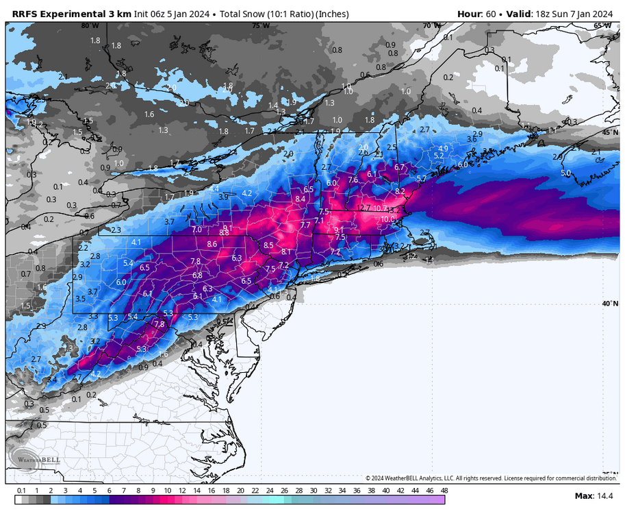
And if your wondering what RRFS is:
QuoteGSL, NCEP/EMC, and other partners are working together on a project to design a single-model, convection-allowing, ensemble-based data assimilation, and forecasting system called the Rapid Refresh Forecast System (RRFS). This project aims to develop advanced high-resolution data-assimilation techniques and ensemble-forecasting methods while supporting the unification and simplification of the NCEP modeling suite around the FV3 model.
Within the NOAA model unification effort, the RRFS represents the evolution of the NAM, RAP, HRRR, and HREF systems to a new unified deterministic and ensemble storm-scale system. This new system is targeted for initial operational implementation in late 2024 as a planned replacement for the NAMnest, HRRR, HiResWindows, and HREF. While the standalone regional (SAR) FV3 model is being developed for convection-allowing forecasting of a limited area (CONUS), other possible components of the RRFS are being tested now in the experimental, WRF-based High-Resolution Rapid Refresh Ensemble (HRRRE). Experimental runs of the HRRRE at GSL are focused particularly on:
- Improving 0-12 h high-resolution forecasts through ensemble-based, multi-scale data assimilation
- Producing spread in 0-36 h ensemble forecasts through initial-condition perturbations, boundary-condition perturbations, and stochastic physics.
-
 5
5
-
16 minutes ago, Bubbler86 said:
Right, and I was thinking it may be due to the transfer where the OH Valley Low peters out and the new low is too far north to subject us to its CCB goodness.
6z Euro and NAM really are tracking inside (NW) as the low comes out of the Gulf. I don’t think it’s really a Miller B, it tracks directly thru the southern apps to just under DC to the northern Delmarva and then finally just off the coast. The part of the track over the southern apps distorts the surface pressure contours giving it that double low appearance.
Either way, a track like that’s getting too far inside for the LSV southern tier… as I’m sure you guys are aware. It’s a big shift in especially the NAM between runs. The 0z 3k NAM run last night had me on the edge barely getting 2 inches of snow. This mornings 3k has borderline warning snows all the way into Pittsburgh/western PA.
-
4
-
 1
1
-
-
3 hours ago, TinGTown said:
This may be banter, so I apologize in advance if I'm breaking rules. I live in DC and have a freshman at PSU. We are driving from DC to State College Sunday, leaving about 10:30. I have no experience with Central PA weather. On a good days it takes about 4 hours to get to State College (after stopping in Breezewood for a break). Even on good days the fog at higher elevations on 70 is terrifying. Everything I have seen forecasted for State College is 4-8 inches. What is your formats for State College?
Also, do you think the roads will be ok Sunday?
Thank you so much for your help. There are thousands of kids driving back to PSU this weekend. Any advice is welcome!
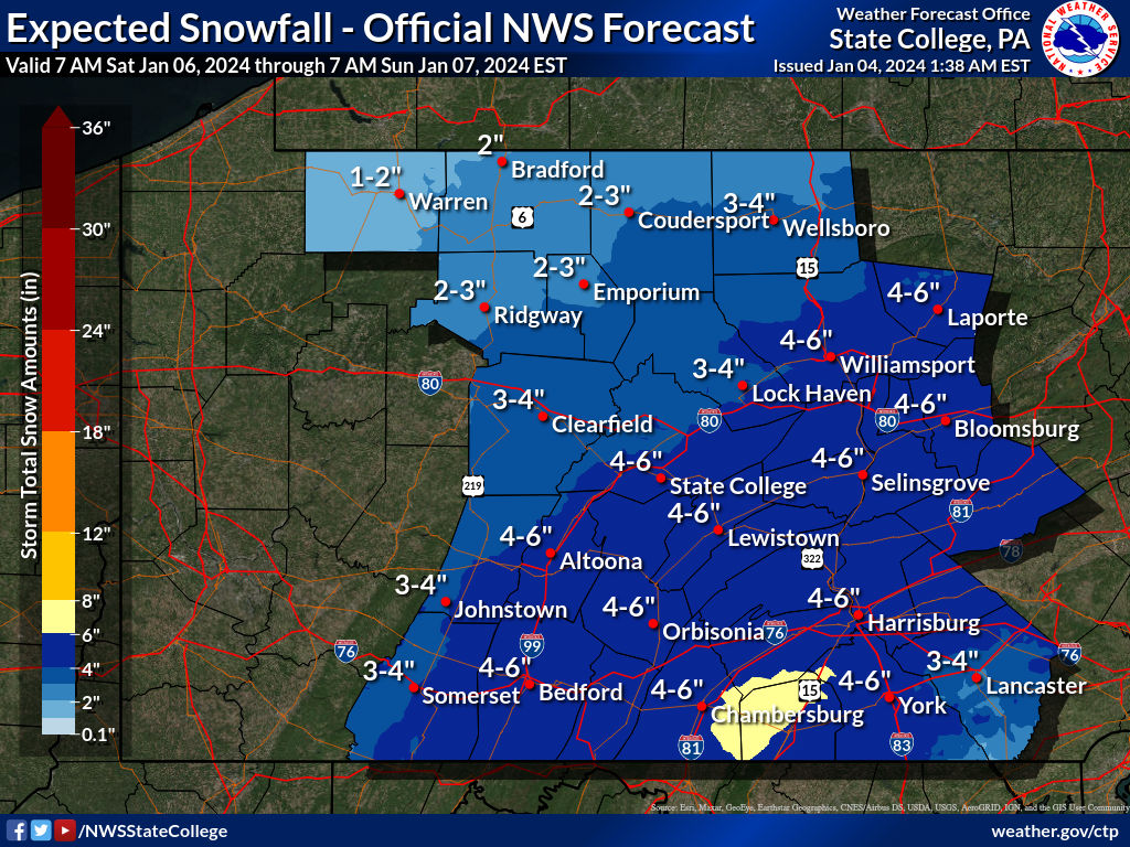
No problem, sorry I didn’t see your post earlier. Fortunately the bulk of the event is now progged Saturday with the heaviest snows likely coming in the late afternoon/early evening timeframe. That 4-8” range is still my thinking for around here. I would imagine by Sunday afternoon the worst will have been cleared up in State College, especially if it’s move-in weekend.
One thing to maybe watch is some lingering lighter snows on Sunday that’s been showing up in various forms on the models associated with that second shortwave. The I-99 stretch of the trip would be where to mainly watch for that. .. specifically the stretch from Bald Eagle (Exit 52) over Skytop Mountain to the Atherton St Exit (69). Otherwise high temps on Sunday look to be around or a bit above freezing so the roads you’re taking should generally be in good shape.
-
34 minutes ago, pasnownut said:
Great read as always. Good luck out there, you lucky bugger.
Thanks we’ll see how it goes. I’ll feel better when/if I’m measuring non-digital snow haha.
-
1
-
-
While I’m at it might as well address the other event that’s quickly on the heels of our weekend system slated for Tuesday before we really get honed into observing the weekend event. I guess it’s sort of the elephant in the room in regards to how much of the snow that does get put down on Saturday lasts. Gotta address the bad with the good, I suppose.
Obviously poised to be a cutter, and it looks like it‘s going to be a bomb. Overnight Euro had it going under 970 crossing western Lake Erie, GFS was 980ish. This is likely to be a pretty high/multi-faceted impact system for C-PA. Wind/Hydro look like the main threats, with wintry impacts on the front end possible in the interior central PA counties. Euro/GFS have a 70-80kt+ southeasterly 850mb jet thru PA on the front side and obviously strong winds on the backside as well. Frontal passage could easily involve severe in the wind dept with that kind of a low level jet if some part of the southern tier briefly gets into the warm sector. Euro was more suggestive of such things. GFS held more CAD and 6z tried to secondary toward the coast. Either way I think the Sus Valley is looking like mainly rain for this particular event, which would invite flooding potential. These things were all mentioned in CTP’s morning disco.
-
3
-
1
-
-
18 minutes ago, anotherman said:
Not to mention the Atlantic is still on fire. You need to be in Manitoba to escape the ocean influence.
I just think it’s boiling down to the antecedent airmass in place and the storm evolution itself. We’re set up fairly decently for this event as far as features in place but the antecedent cold isn’t very impressive. The high is there but it doesn’t seem like it’s being progged to be very efficient with drawing the cold air associated with the high into the system much at all until the storm gets going more off the coast under New England when it’s past us.
This is where I think the earlier miller B solutions would have been better for us. A more developed primary trying to come up and transferring under us would have established the northeasterly flow to draw more cold air from the high. This has become pretty much a straight miller A that’s winding up later and making the event here pretty much an quicker hitting 8-10hr one for the best precip… and it’s not pulling in more cold during the event in time to push the rain/snow line in our region. Surface low track is going to be key and a little bit of difference is going to go a long way either direction in that LSV southern tier.
-
1
-
4
-
-
The opening run of the CTP is out. First winter map issuance from them regarding the weekend storm.

-
3
-
-
16 minutes ago, Bubbler86 said:
Rgem still rolling large albeit it a bit too far west for everyone's comfort in the LSV.
To further on what Anthonyweather shared a couple posts above from DT about the miller A vs miller B scenario, the Miller B scenario in this case would have been best for a longer duration system and more of a broad shield of precip across PA. The A solution that most guidance has settled upon shortens the duration and tightens the band of best QPF up since the system itself isn’t progged to be overly strong anymore. So the folks that see some of the best amounts are probably gonna be living dangerously in terms of the proximity to that changeover line.
-
1
-
-
While the NAM itself seems completely disinterested in making any kind of event at all in PA, the SREF blend looks surprisingly reasonable. It generally sits in between the Euro EPS and the lackluster GEFS blend. I think the NAM eventually picks up on it the next few runs. There’s too much support for an event across the board to reasonably think otherwise at this point.

-
6
-
-
6 minutes ago, paweather said:
What is meant by fits the pattern?
Could be a couple of things. I won’t put words in anyone’s mouth but here’s my objective thoughts on some of the cons of this setup.
Precip issues are still possible in the southern tier even with these lower QPF/progressive solutions depending on the thermals.. something we won’t have a firm handle of till we’re in range of the high res guidance. I do think we’ll see mostly snow in here from this, but the possibility of some mixing in the southern tier still exists. We’ve changed the pattern around to where it’s cold enough and we have a high available for this system, but it’s still not significantly cold here.. just cold that’s average.
The 500mb pattern out west is not typically what you would see for a C-PA snowstorm. We’re always looking for the big western ridge and associated amplification to run a coastal storm all the way up the coast and we have the complete opposite with the -PNA setting up and a big western trough. What makes this work is having some downstream blocking and 50/50 low allowing this shortwave that kicks out from the southwest go underneath us. What’s being pointed out by some is these weaker solutions late today along with being faster come from more energy dumping into the southwestern trough (which eventually becomes our next headache next week) making for a weaker shortwave (that becomes our weekend storm) that kicks out. That kind of evolution takes away the top end potential. This is still probably a half decent event but not a blockbuster 1-2 foot type thing. More of 4-8” kind of event is what I’m thinking right now for the swath of heaviest snow… which I think about anyone in here would be happy with.
-
1
-
7
-
-
16 minutes ago, Itstrainingtime said:
So you're saying that Elliott, who is a great met, is totally wrong when he said that the models do NOT fit the pattern?
Speaking of keeping expectations in check, lol. I’d make a sizable bet stuff like this is what he’s referring to. I just took that screenshot so 5hrs ago was after the 12z suite today.
-
 1
1
-
-
18z Euro EPS vs 12z, still okay but means are down a bit.
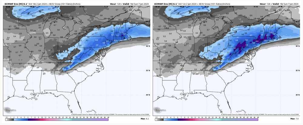
-
18z GEFS mean still involved most of PA but was def lean on QPF.
Total QPF mean

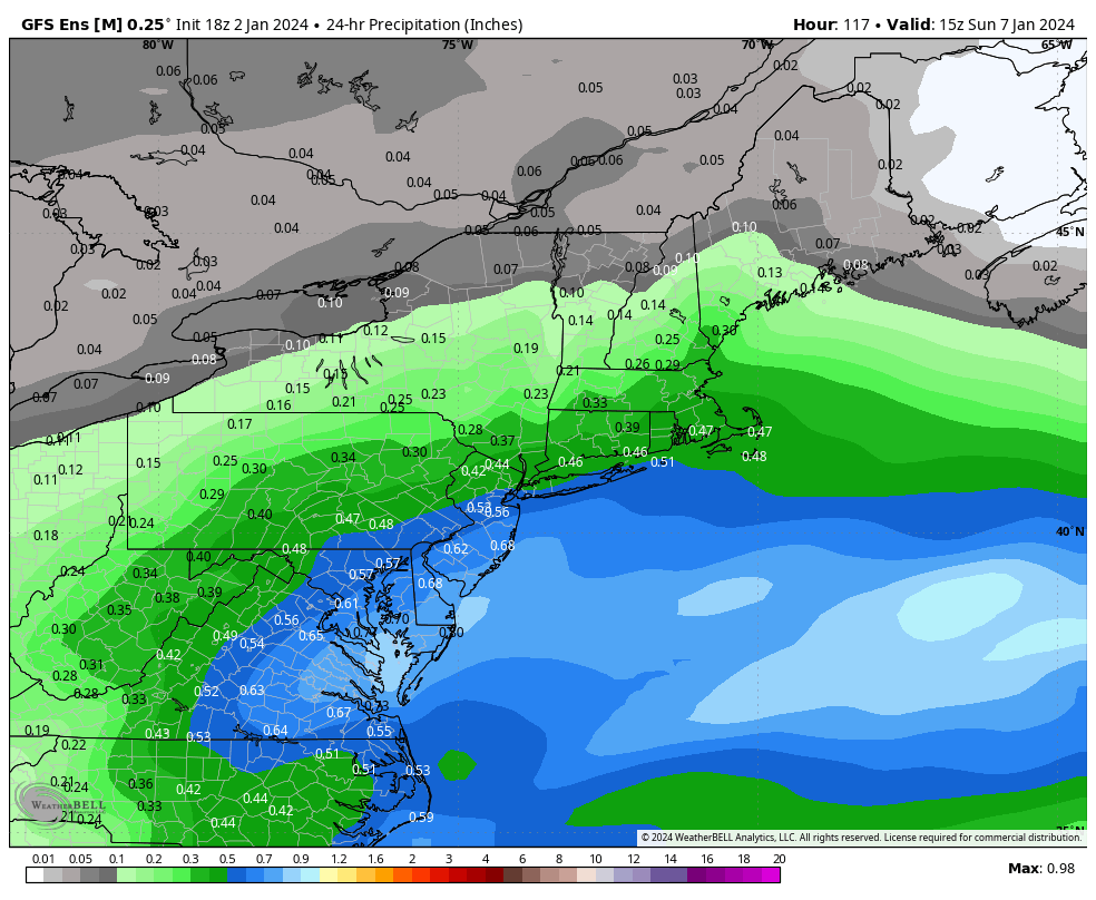
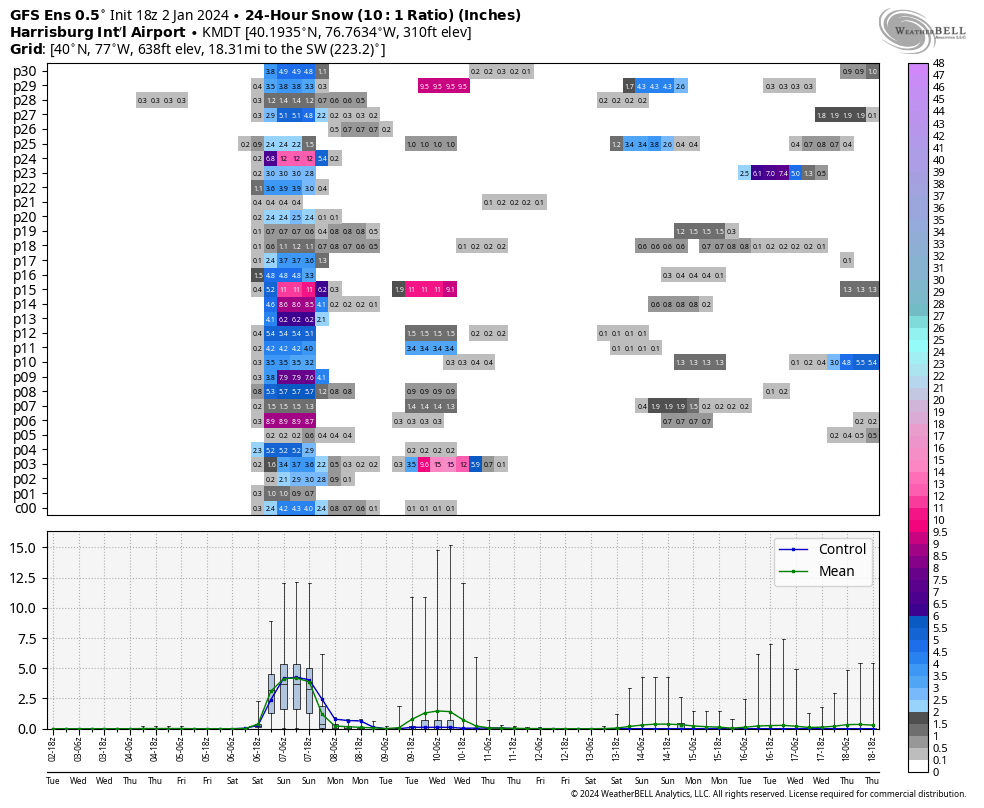
Let’s have a look more specifically. Here’s MDT’s 24hr snowfall on the individual members.
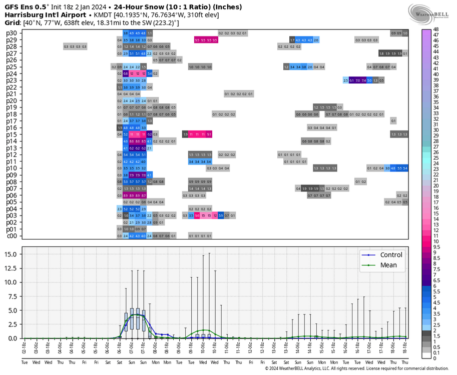
The majority show at least advisory snowfall, while only about 1/3 crack warning criteria (5”). And there’s about 8 members that would be sub-advisory type snowfall. This was a really progressive run on the GFS/GEFS this go around. Is it right? I dunno.. Usually Gulf lows find a way to have a nice precip shield with it and I think this might have went a bit far on the dry side. The more progressive/less QPF trend was noted just about everything today though. This thing is just starting to come onshore on the west coast, so the next few runs will be interesting to see.
-
3
-
-
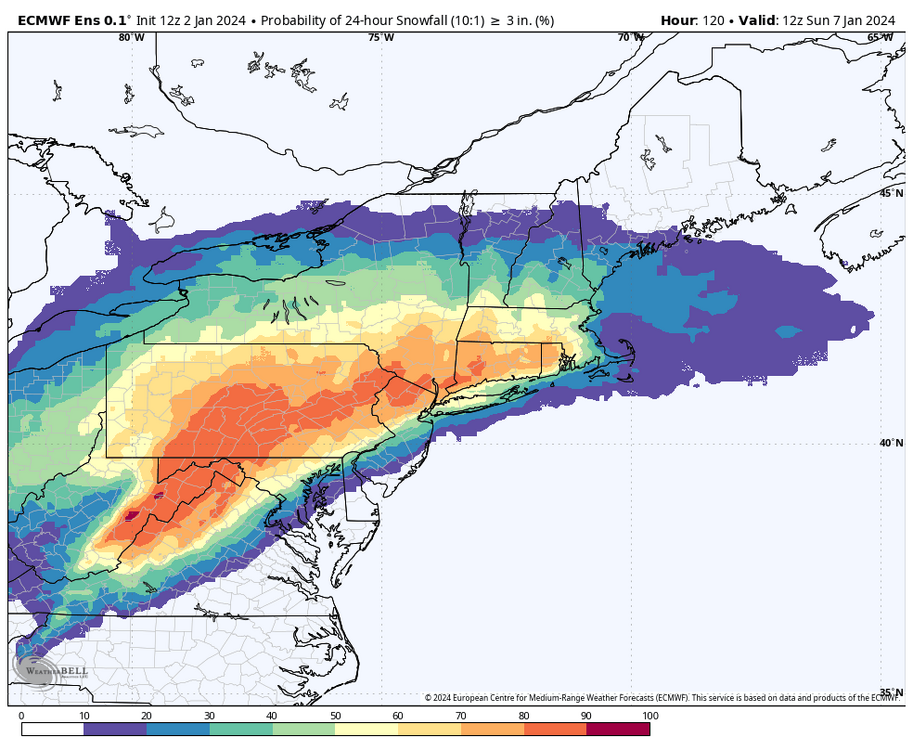
To further on the 12z Euro EPS
3”+ probs
6+ probs
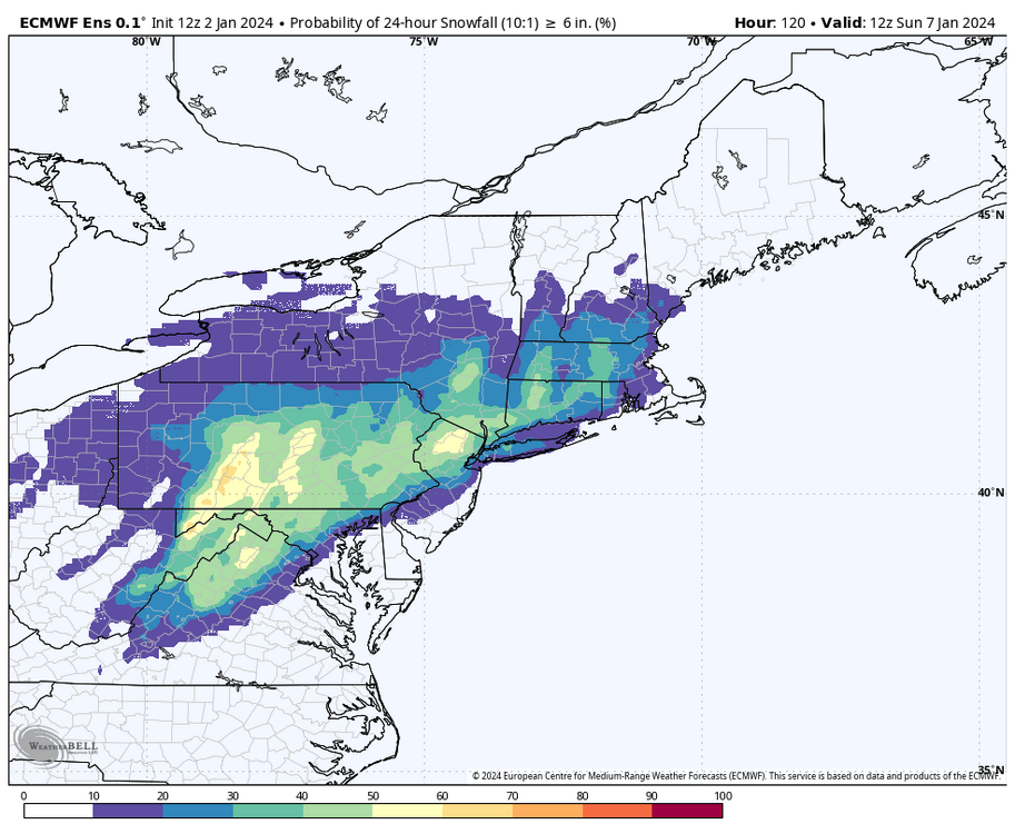
Edit to note that the 12”+ probs are completely non-existent (no ensemble member showing 12+), so the ensemble overall has definitely picked up on the faster motion of this storm.
-
5
-
-
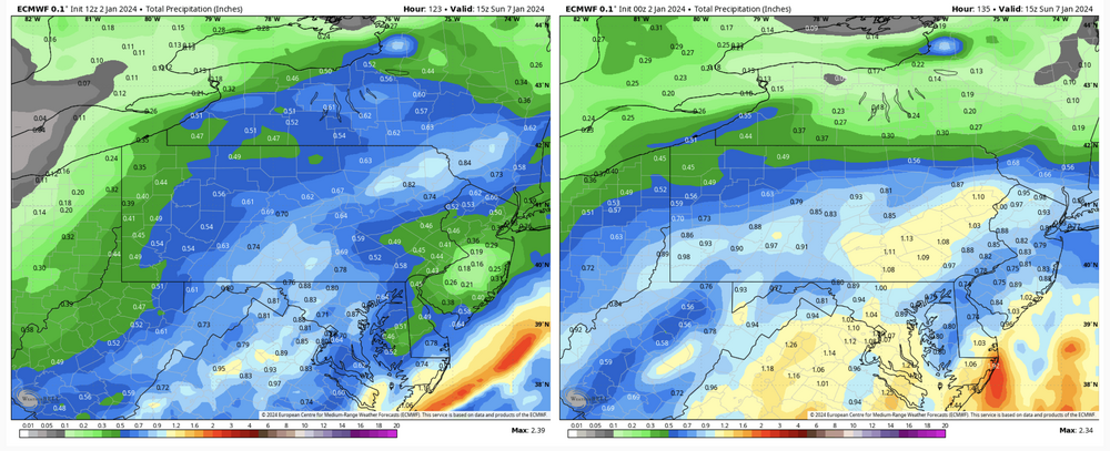
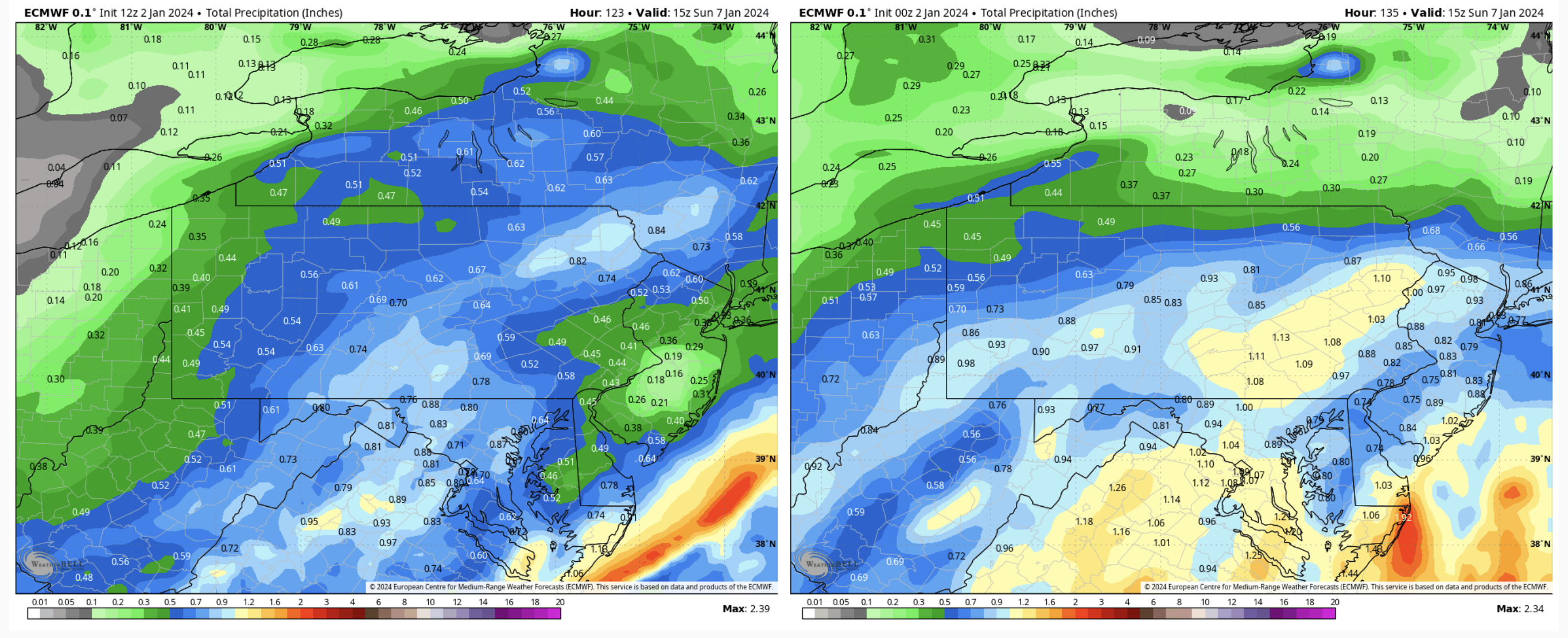
The biggest difference in the Euro 12z vs 0z is by far the total QPF. A difference of 0.5”+ (less) in the Sus Valley.
-
12 minutes ago, Atomixwx said:
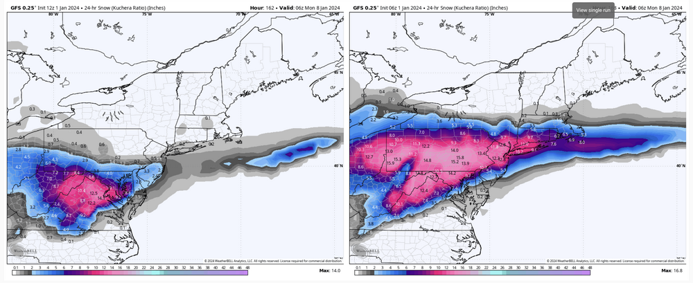
Look at that Kuch. MAG is the big winner if that verifies.
Sent from my motorola edge 5G UW (2021) using Tapatalk
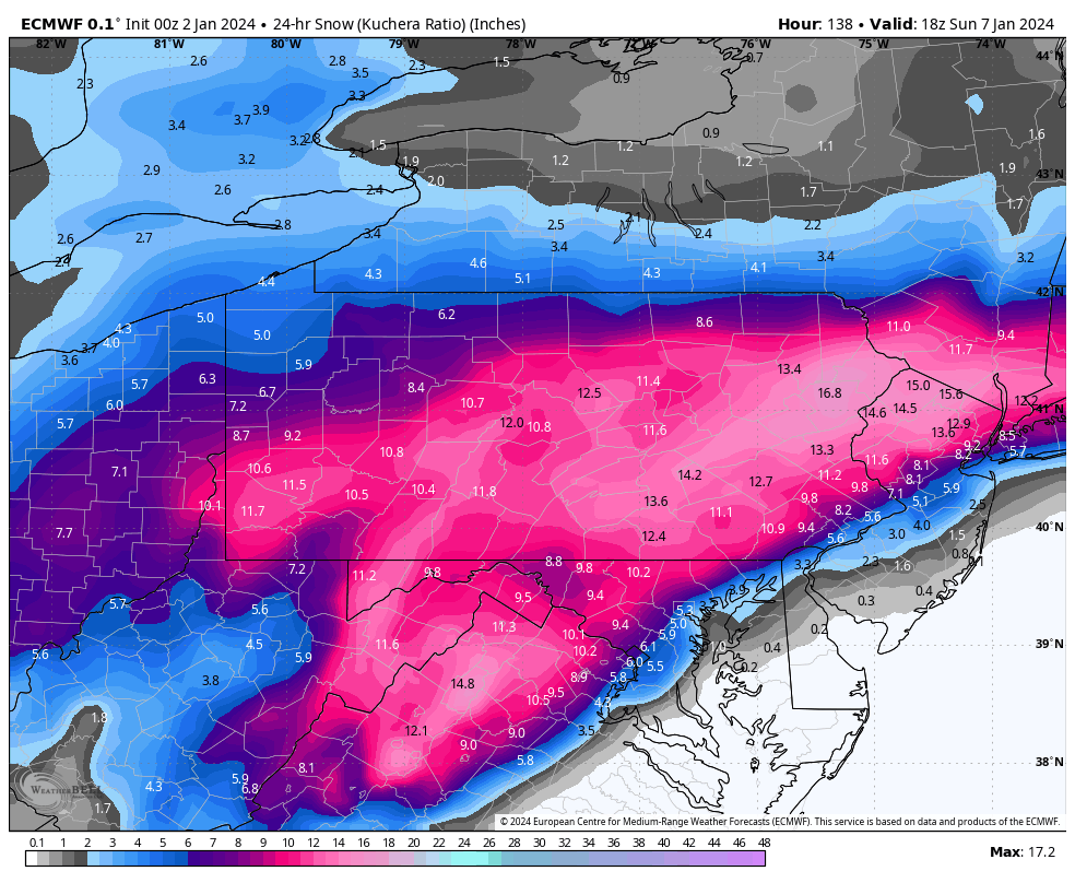
We’ll see haha. This system has been trending a bit faster both in onset time (mid-late afternoon Sat) and certainly in duration as it’s looking more like a 10-12hr event now. So I think if there’s an area of double digit amounts to be had with this, it’s likely going to be from getting >10-1 ratios. C-PA should see the best zone of 700mb lift and temps at that level for the event over the subforum are generally -6 to -8ºC. Those are okay numbers but not in the ideal range for the best snow crystal growth. There’s sufficient cold for the snowstorm but not for a high ratio event (like another 1/7 storm from way back). So I think 12-13 to 1 is probably the high end for ratios, which is only average for a snow event this time of the year in C-PA. These Gulf storms usually have the smaller flakes that make for a dense snowpack as well.
-
1
-
-
28 minutes ago, Bubbler86 said:
Here is a skew-t from TT when it is showing rain in much of the LSV. Definitely model site differences in interpreting the data but the Kuch snow map on Pivotal does look like one that shows the southern parts of PA had mixing issues regardless of the preip maps so it is close. I do not have WB.
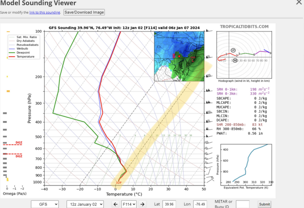
Yea, that’s an isothermal layer from surface to about 850 thats essentially between the 32-33ºF range (highlighted for you). Light rates might be drizzle/freezing drizzle depending on surface temp, but moderate to heavy rates would likely be snow with that kind of skew T presentation.
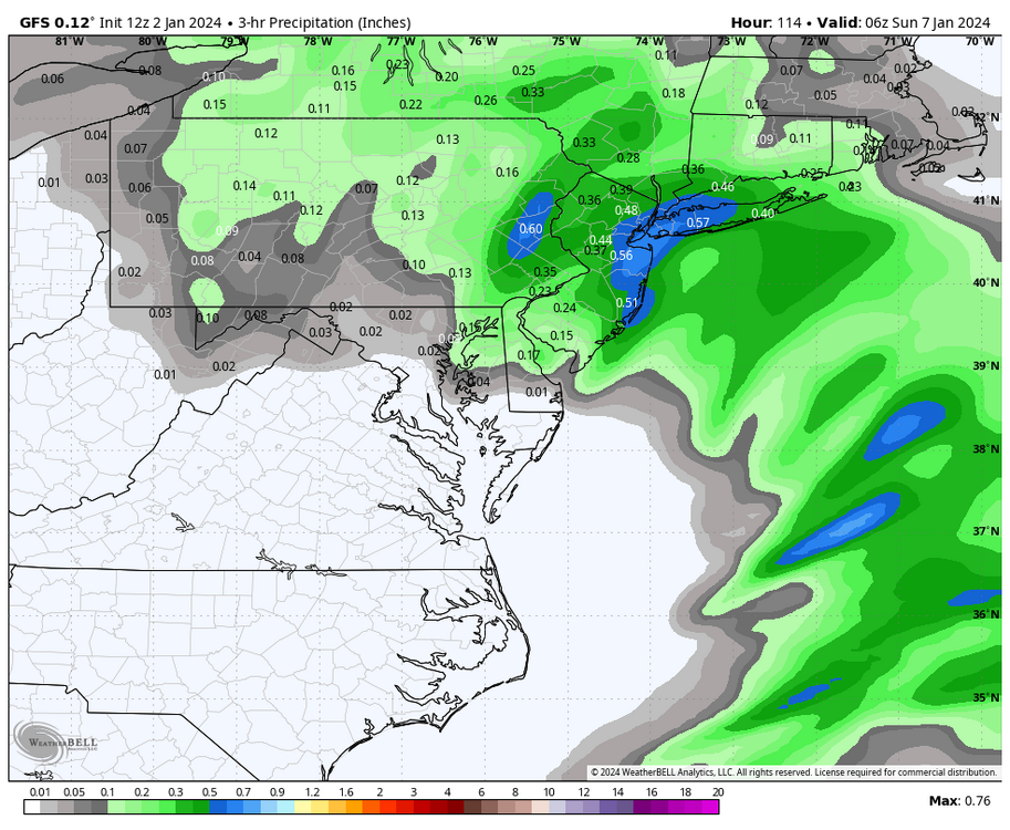
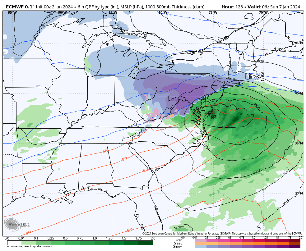
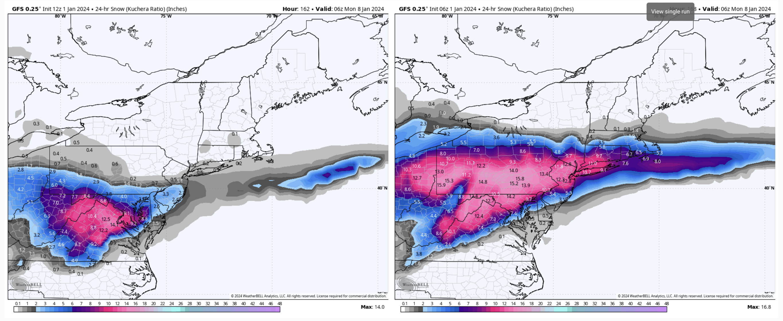
Here’s the 3-hr precip from 111-114. A couple tenths fall in parts of Lancaster in that timeframe, but the rest of LSV west of there is mostly done at that point. That’s the furthest north I’ve seen the GFS take the primary with its Miller B solutions. The low’s weak and the transfer is already occurring so it still kept most to all of the state snow but the other part of that equation is the best overall QPF in the frozen precip zone went deeper into central PA. Though I suppose there’s not a huge difference since everyone in here generally gets in that .75-1.00” range.
Obviously one model run and a global model at that, but we are getting into the range we can start scrutinizing the details on these runs more. The high res stuff when we get to that range (NAM, HRRR, et al) is where we’re going to really hone on the thermals.
-
3
-
-
5 minutes ago, Bubbler86 said:
Different model sites use different algorithm's for the precip type. Here is TT showing the changeover. Pivotal's maps do not show the same but they decreased snow in this same area just the same.

Weatherbell really didn’t send a changeover across the Mason-Dixon Line. I know the algorithm gets a rap for being snowy or whatever but that particular map is a 6hr frame and if you use a 3hr frame bulk of QPF is thru York/Lancaster by 111hr. Thermals at 850/925mb/surface are still fine at that point. At the 114 hr frame the 850mb 0 line is shaped pretty much like the changeover line on that TT map but the 850 temps are still within tenths of a degree of zero in that little rain area that intrudes into PA as are 925 and surface. So if there’s any heavier precip left between that 111-114hr frame there it’s probably going to be snow… albeit likely at reduced ratios.
-
7
-
-
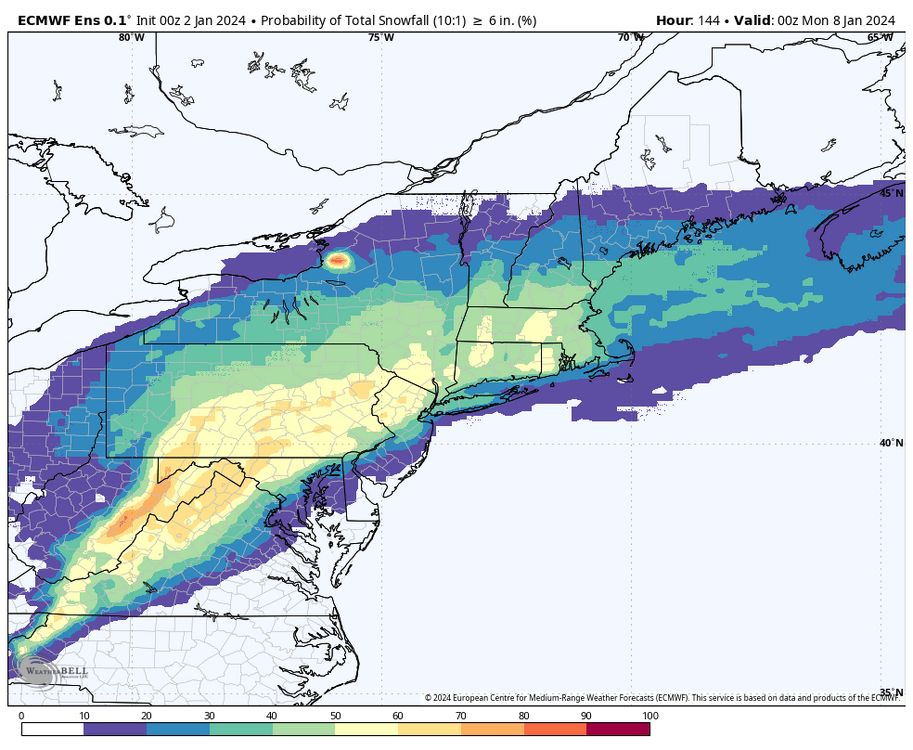
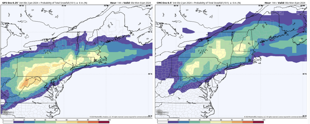
0z ensembles for 6”+ probabilities. Euro up top with GEFS v. Canadian ensemble comparison underneath.
-
0z Euro right in the zone for C-PA snowstorms (Low on the Delmarva coast). Figured I’d contribute a little bit to the pbp haha. The 0z suite as a whole is definitely solid tonight.


-
4
-
-
Well the run to run consistency was fun while it lasted lol
-
 1
1
-
-
Snow of varying rates has been occurring here throughout the evening, with about a half inch of wet snow on the deck and grassy surfaces.
Temps hovering just above 32ºF (32.5ºF currently). Going by the tenth, my weather station still actually hasn’t gotten down to the freezing mark at any point since overnight Dec 23rd.
-
18 minutes ago, Atomixwx said:
Okay, this is actually an event. I'm in Port Matilda and the ground has caved.
Sent from my motorola edge 5G UW (2021) using Tapatalk
Same here with a coating. Got a nice burst of snow going right now too. Pittsburgh radar showing what should be another wave coming through later on this evening.
-
1
-
-
I’m sure we’re all aware of the risks here at this lead time. My concern is of course, the relentless creep northward of the changeover line as we get to closer lead times. The good thing is we have the features we need in terms of a 50/50 low (with some Greenland blocking to hold it) and a surface high with cold air that is available. This is a really short wavelength pattern in the CONUS with the big trough already dumping into the west as the 1/7 system is approaching… so I feel that actually should help in this instance in combo with the aforementioned downstream features as heights won’t be able to build ahead and allow the storm to fully cut. The storm that’s been immediately following in the progs next week is a different story but that’s a bridge to cross on a later day.
Evolution on guidance has been trending towards the miller B solution, so how far the primary drives is going to be the key there. With what I see currently, I think the transfer should happen underneath us… with the possibility of our southern tier getting into some mixing issues at some point in the event. That doesn’t have to happen though, we have the potential for an all or mostly snow event for the subforum here.
-
2
-
3
-


Central PA Winter 23/24
in Upstate New York/Pennsylvania
Posted
The upcoming 7 days or so are going to be a bit rough other than for this storm chance. Temps are going to be a bit above average along with the big time cutter. Significant cold in Canada dumps in the west at first with the -PNA so we’re looking at a cold west and warmer east. Getting toward week 2 we develop a -EPO/WPO to go along with the already negative NAO/AO. That should allow the cold to push east in time. It is definitely a nice look, though a wildcard in there is the MJO and what that does. Models eventually have it running through 4-6 at differing degrees of magnitude.