

MAG5035
-
Posts
5,718 -
Joined
-
Last visited
Content Type
Profiles
Blogs
Forums
American Weather
Media Demo
Store
Gallery
Posts posted by MAG5035
-
-
3 minutes ago, Amped said:
So Altoona is already above the NWS forecasted?
It’s right in the middle of the forecast range right now for the advisory, which for this county was 2-4 with up to 6 on the ridge tops. The ridges probably do have a bit more but in general the elevational component is out the window at the moment in this area.
The key late this afternoon into part of the evening is going to be how the precip shield evolves as the coastal winds up. If we remain in the steady moderate to heavy precip which seems to be a possibility on the last couple runs of the HRRR than yea, this is definitely going to overachieve and probably be a warning event. But if we get a lull or miss the banding that winds up from the coastal, it’ll probably be close to what was forecasted. Either way, this is impressive for being right at the max solar part of the day.
-
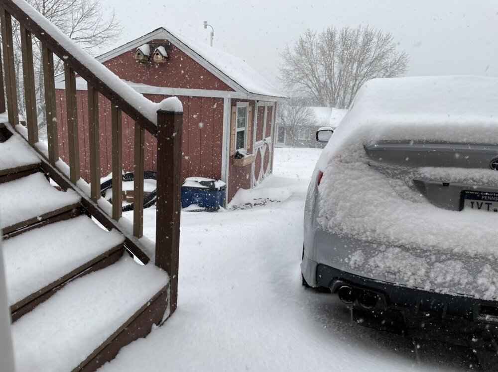
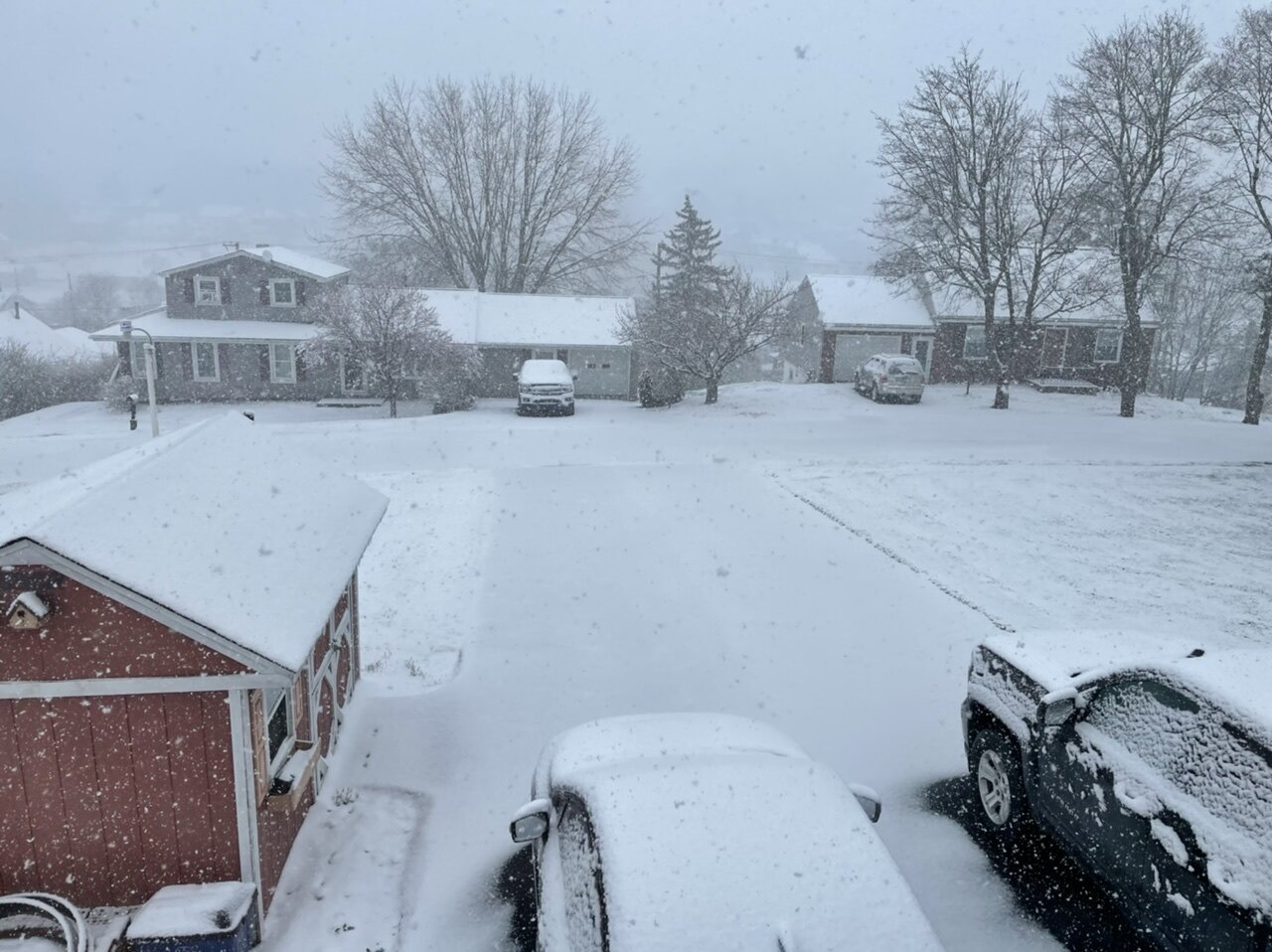
Just measured 3.2”, still heavy snow and 31.5ºF. What a beat down.
-
 6
6
-
-
3 minutes ago, Bubbler86 said:
LOL. We are at the best rates of the year (close/tied). The grass is 3" high and its well on its way to being covered. It may not officially be 3" of snow but we are approaching 1" in the grass now with the sticky snow piling on top of each other. A good 1/2" in the last 15-20 min.
I was about to say that the best part of this is that it’s probably the best synoptic rates I have seen the entire season and it’s happening on April 18th.

-
6
-
 1
1
-
-
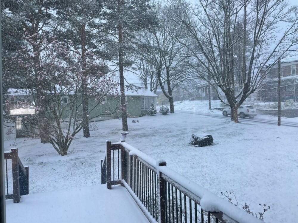
Past an inch on the ground, it is pouring snow right now. All paved surfaces are caving. Temp is 31ºF.
-
5
-
-
24 minutes ago, Voyager said:
I have a postage stamp sized yard so I have a battery powered cordless mower. Just bought it a few weeks ago to replace the corded electric one that was 15 years old.
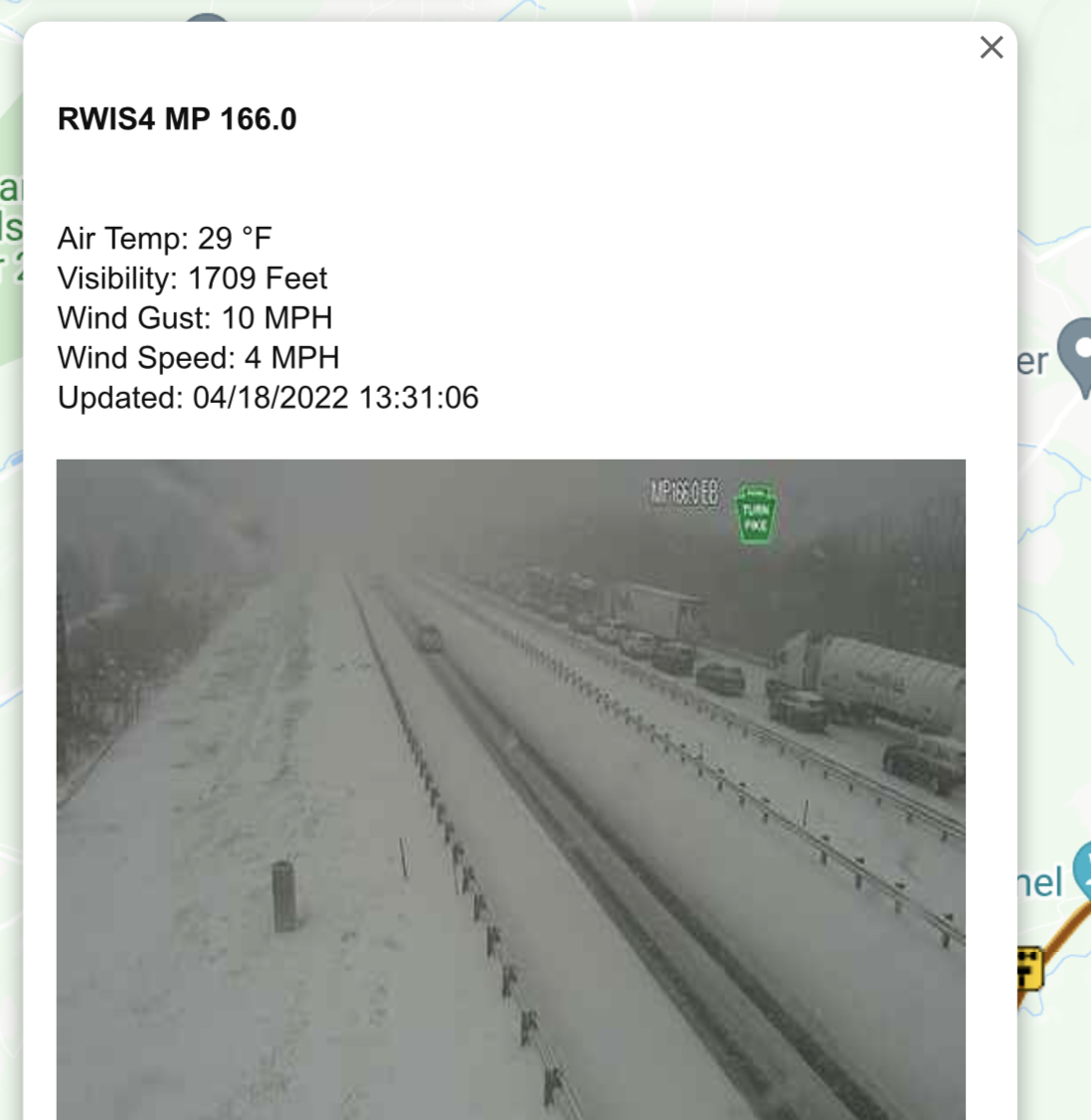
Check out this 511 cam on US22 at Gallitzin. Who says it can't accumulate on paved surfaces during the day in late April???
Even the turnpike is fully caved. It seems like Bedford and Fulton are getting whacked right now. This screen grab is just east of Breezewood. That stretch from Bedford to Breezewood is all covered.
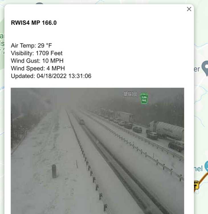
This was what I was alluding to yesterday with all bets being off regardless of elevation if we had heavy rates collapse the column and a quick/clean transition to all snow. That stretch of the turnpike is not a high elevation area other than the Sideling Hill area.
-
1
-
-
Snow rates have really increased with a pretty heavy rate currently. Temp is down to 31ºF and accumulations are starting to occur on most non-paved surfaces.

-
2
-
-
Over to all snow now with 36/21.
Some 511 cams already have snow on roads down in Somerset County, even on the turnpike near the Allegheny Tunnel and also 219 near Meyersdale..
-
Light precip just commencing here on a pretty stiff southerly wind gusting to about 25 mph or so. Mainly pingers so it’s already a frozen form. Temp is 38ºF but the dewpoint is 18ºF, so I expect a clean snow transition and a quick temp drop to freezing when the much heavier stuff on the doorstep arrives.
-
2 hours ago, TugHillMatt said:
Do you guys have extensive foliage out on the trees down there? If you get this heavy snow, it could do some damage. We are in extremely early Spring mode up here still, so I don't see it being a problem. It would still be some heavy snow on everything!
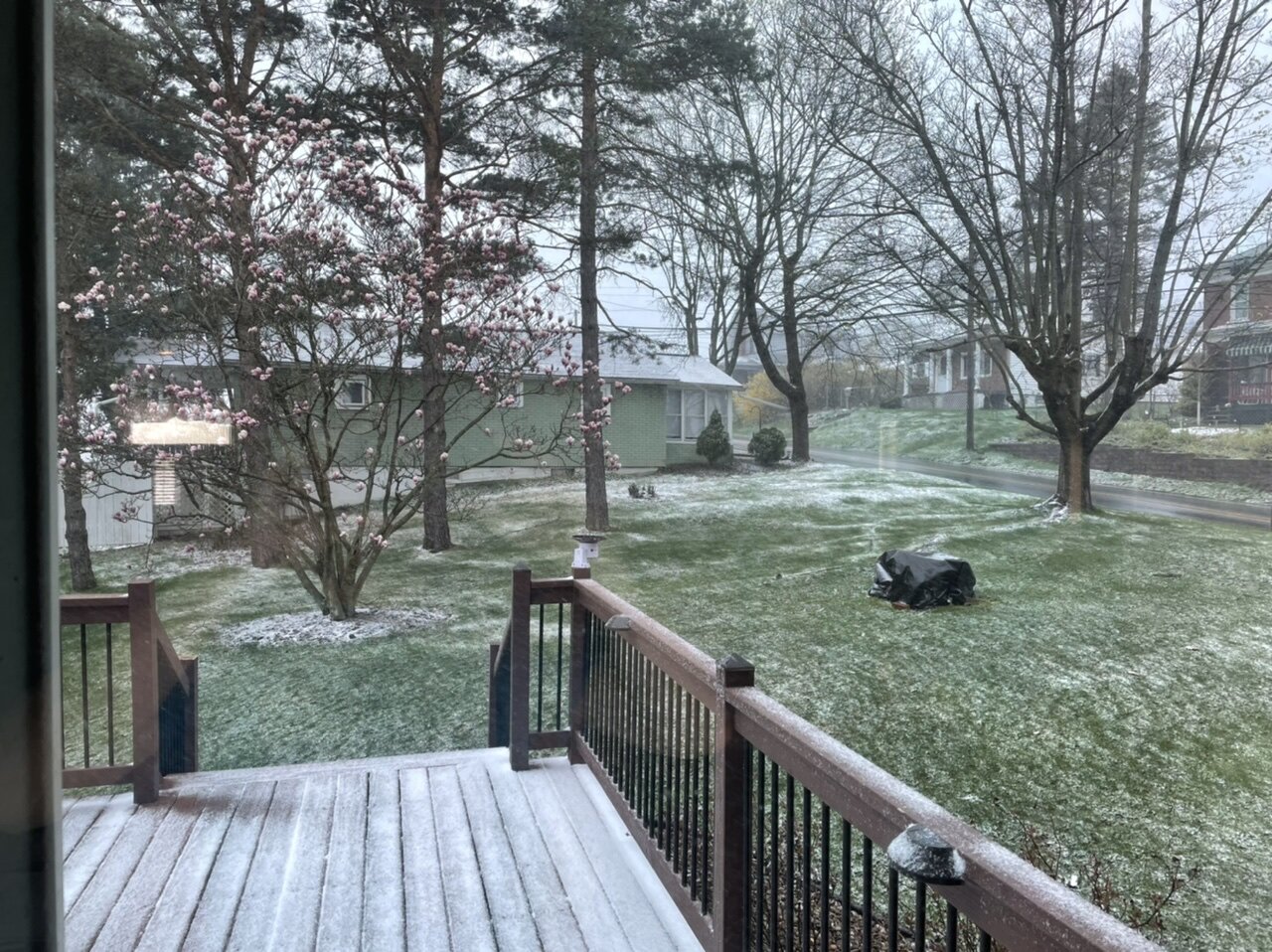
Some trees have blossomed out along with stuff like daffodils and Magnolia blossoms but at least in this area there is basically zero leaf out of anything to this point thanks to what has been quite the bi-polar month that has been chillier more often than warm so far. And that’s down here at this elevation in the valley (and also in town), so fortunately if there are significant amounts that aspect shouldn’t be a factor.
-
1
-
-
53 minutes ago, losetoa6 said:
This storm really reminds me of April 23-24 , 2012 when I was out near Somerset, PA and got 12-15" .
Laurel Summit got 20"+ I believe
It took a minute to jog my memory since I was thinking of another late April cold snap and snow but yes I remember this storm. In fact, the C-PA thread at the time is still back on about page 10 of the Upstate NY/PA forum ( I linked it below). Obs/pics were discussed roughly in the Page 18-20 range and I didn’t get too far into it but I’m sure there was plenty of lead up discussion. Really shows that the C-PA thread has been going for a long time (with several of the same personalities as well) haha.
Anyways, I think that storm was a stronger one but I do believe this one might have better preceding cold. Certainly at 850mb.. this event looks to be starting tomorrow with temps at that level easily below 0 in central/eastern PA. We actually don’t need the dynamic top down cooling to initiate changeover as it will already be cold enough. It’s a matter of overcoming warmer boundary layer temps which is where the elevation factor/solar/timing plays in.
Back with that 2012 storm, it went from zero accumulation in the valley to 6-10” at the top of the Allegheny Front here. I honestly don’t expect that kind of variability with this as I’m expecting something notable on the ground at my spot (at least a couple inches). This probably doesn’t have a problem mixing with snow in a lot of places into the Sus Valley but if there’s a clean transition period in some region of C-PA with heavy rates then I think all bets are off and decent accums happen in lower elevations as well. I still think you need to be above 1000ft and west of the river for seeing any accums.
-
1
-
1
-
-
22 minutes ago, Blizzard of 93 said:
Actually, please let us know your thoughts on Susquehanna Valley’s snow chances if you get the chance.
I think it’s possible it could mix with snow some in the metro areas, or certainly at least the Harrisburg area… not sure about all the way in York/Lancaster though I certainly wouldn’t say the chance is 0%. I do expect it’ll be mainly rain SE of I-81 except for some of the ridges which may have some snow and maybe some minor accumulations. The low track’s pretty good if not a tad inside but it’s a matter of getting cold enough air to the low levels in eastern PA and this is a more dynamically driven setup with getting it cold enough. So I don’t think it’s quite there to get much into the Sus Valley.
Between here and the Susquehanna River in the ridge and valley region will likely present the greatest variability in potential snow accums from an elevational standpoint with the deeper valleys. This is probably a >1000’ elevation type deal to see accums and like a >1500-1600’ to see advisory+. A total collapse of the column and heavy rates could mitigate the elevational variability but that seems mostly likely to happen deep in the central and esp northern part of the state.
-
1
-
-
Had some flurries this morning. This makes it 2/2 for snowing on Sunday this month and the last 3 Sundays in a row..
I’ve been fairly busy and not able to post much but have been keeping an eye on tomorrows system. It did catch my attention that models across the board have been pretty robust on accums the last few days in the central counties and it looks like CTP is finally starting to oblige to that reality with ramping up their grids. It’s probably not enough either. Laurel’s and north central counties are likely looking at some kind of a headline event.
This is obviously a highly diurnal and elevational situation, seems like arrival of significant precip is slated for the late afternoon and going into a good bit of the evening. It looks like a pretty decent slug of moisture so that coupled with the developing coastal low will probably promote a quick changeover to snow in the central counties and remain so if rates remain steady and moderate to heavy. If it’s heavy it will eventually accumulate on most things despite all the ad nauseam springtime disclaimers, especially getting towards the evening (after 5 or so).
Not sure what to expect here, though the top of Wopsy 4 miles up the road from me at 2400’ (and similar elevations in the Laurels could get a lot of what the new 3k NAM is throwing down. Down here? It very well could end up an advisory type event with a quick decisive changeover and heavy rates. Certainly expect to see some kind of accumulation at this point being at 1300’. I will say the overwhelming factor in favor of me seeing 8-10” is the fact I rolled the dice and I pulled the mower out of the storage garage and put the snowblower away yesterday.
-
31 minutes ago, Bubbler86 said:
Again, driving way too fast for the conditions.
Definitely, and he barrels up on this wreck seemingly unaware at a point when people are out of cars and stuff is on fire. Do a lot of truckers just not utilize things like CB radios as much anymore? And I even hear a CB radio in the background toward the end of that video.
-
Temp was briefly under 20ºF with the passage of a brief snow squall. 25.5ºF is as high as it’s gotten this afternoon. Peak wind of 41mph today. Just a brutal day as March 28ths go.
-
1
-
-
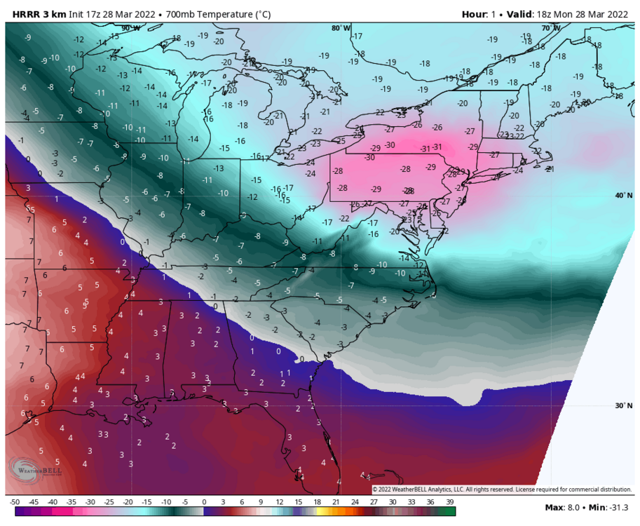
Insane cold temps aloft today, certainly a big driver in terms of lapse rates and instability with these snow squalls today and their long reach away from the lakes/mountains. Then you add in the late March solar/diurnal component. Core of cold at 700mb is moving over PA this afternoon with near -30ºC temps. Given heights, that’s only at approximately the 9200ft level. You have to go above the Arctic Circle to see similar cold at that level anywhere else in the N Hemisphere.
-
1
-
1
-
-
51 minutes ago, Bubbler86 said:
@Blizzard of 93, do not really see any sustained warmth on the ensembles. I am sure you can find us some nuggets of good (more snow?) the next few days.
Well for some of the western and northern zones, that next nugget comes tomorrow in the form of a sneaky clipper haha. I don’t think much of that will make it into the Sus Valley though.

-
1
-
-
3 hours ago, Voyager said:
I don't really understand the science behind this, but my station currently is reporting 181.3 watts/m².
Some solar (shortwave) radiation will still radiate through clouds, even in overcast.
Speaking of solar, despite having temps in the low 20s (down into the high teens at times in snow showers) all afternoon, my driveway has mostly melted off despite having the full accumulation on it early this morning. It gets direct sun plus its a newer blacktop surface so it will still absorb solar despite all that this time of the year.
4.5” is probably going to be my rough total, although I’m going to measure around some. This stuff really blew around.
-
34 minutes ago, TugHillMatt said:
Nice. Looks like it set up right along the Ridgeline. Orographic effects?
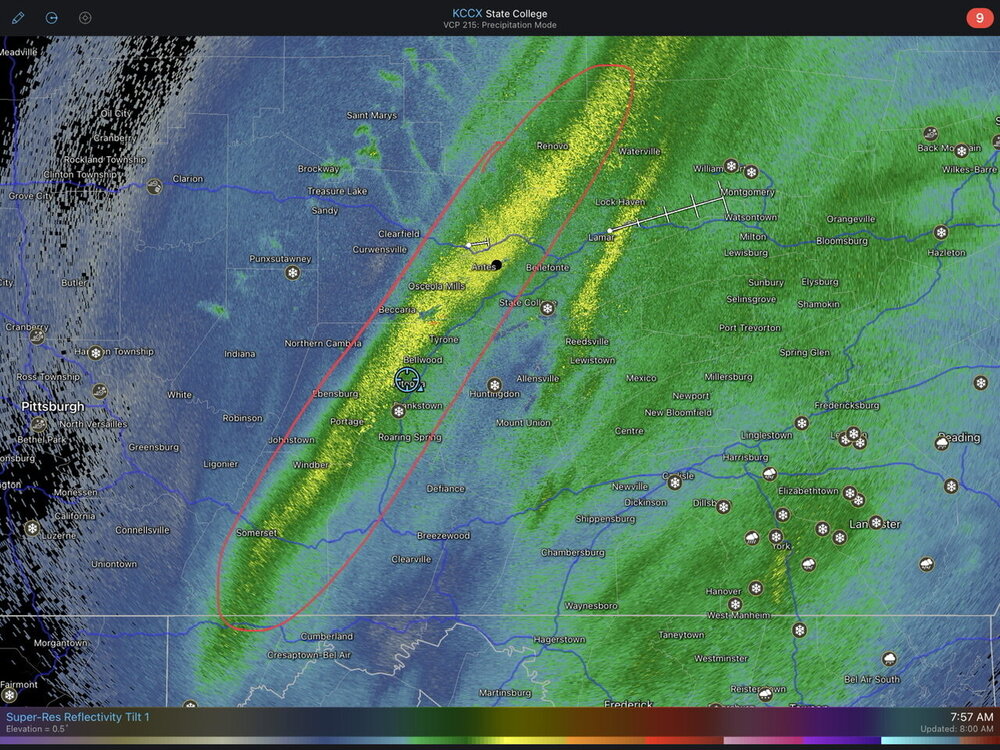
I think that band has more to do with the larger scale forcing aloft, as it has propagated eastward and it’s currently residing from about a Mount Union-Lewistown-WIlliamsport line. It’s actually not ideal orographically on the east side of the Laurel’s. Being an anafrontal type setup vs a more traditional coastal storm there’s no low level easterly fetch that will help enhance from that aspect. If you look closely at CCX radar (and LWX as well) you can see the low level flow is actually northwesterly and even see some of the lake enhanced stuff propagating NW-SE underneath the synoptic precip shield that has the deep southerly fetch aloft. Part of why the good rates will shut off quickly and not linger once that max forcing moves out of the area early this afternoon.
-
1
-
-
Lighter rates now but the wind has really ramped up in the last 15min with the temp falling further (from 24 to 22ºF). Recent high gust to 29mph. It’s gonna be hard to measure additional snowfall.
-
Just measured 4.3”. So that’s roughly 1.5” in the last 45 min or so… a straight fluff bomb. Rates back to moderate.
-
4
-
-
Getting into what’s probably going to be the money band with this. Heavy snow and now 23ºF.
-
6
-
-
Moderate to heavy snow currently and a decent breeze. Have had some 25 mph gusts. Temp already down to 24ºF.
Closing in on 3” here so far and it’s a nice powdery snow that’s already doing some drifting.
-
3
-
-
13 minutes ago, canderson said:
Do a map!!!
Haha I’ll make it simple. I think pretty much everyone in here is good for a mainly 4-8” type event. Actually my biggest concern at the moment resides in my own general area, having watched the 3k NAM and also the HRRR at times showing a soft spot in accums in this particular area (between about here down to Cumberland,MD) between the now established precip shield in western PA and the slug associated with the low itself that arrives from the south.
That could cost me a warning snow if that came to fruition so I’ll definitely be watching how things evolve overnight with that. Other than that, I really think everything looks good for everyone to see their biggest snowfall of the season and likely a warning type snowfall. I think the ceiling on this in C-PA is probably 10” max.
-
2
-
-
7 minutes ago, Bubbler86 said:
This is not 93 but it does have a lot of hallmarks from it. Just moving much faster.
You’d be surprised how fast the 93 superstorm moved. It actually occurred during a +NAO state. The low center went from the northern Gulf off the FL Panhandle to exiting New England in about 24hrs or so. Obviously the insane phasing situation and setup made that a way bigger storm.. This one’s still dynamic though and it has the far reaching significant cold to tap into as well.


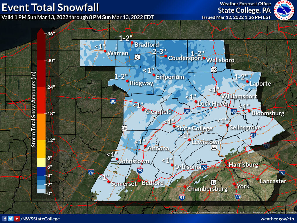


Central PA Spring 2022
in Upstate New York/Pennsylvania
Posted
Still some steady snow falling. The total for the event is currently 4.6” here at 1300’… the majority of which (about the first 3” or so) fell between about 12-3pm. I caved and brought the snowblower back to clear the driveway this afternoon.
I got a rough measurement at the top of Wopsy Mountain 4 miles away (at 2400-2500’) at around 930. There was about 8” up there.