

MAG5035
-
Posts
5,884 -
Joined
-
Last visited
Content Type
Profiles
Blogs
Forums
American Weather
Media Demo
Store
Gallery
Posts posted by MAG5035
-
-
26 minutes ago, Bubbler86 said:
I was focused on the LSV. 10-1 is higher in the LSV (on Pivotal). I see out your way Kuch is higher. 10-1 has Harrisburg at 3 and Kuch is 2.7.
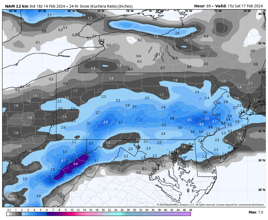
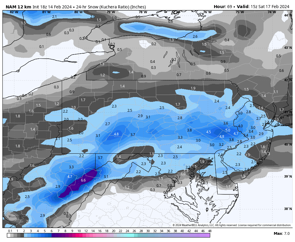
Hmm that’s interesting, Weatherbell is 3.3” Kuch and 2.8” 10:1 at Harrisburg. Splitting hairs at this point in time really but given colder surface temps and a much colder column ratios should be better than 10:1.
-
Here’s the 24 hr Kuchera for the NAM for specifically Saturday. It’s a little bit higher than 10:1.
-
50 minutes ago, GrandmasterB said:
Certainly some weenie optimism in this take, but this is the type of set-up that could bump north in the last 24-36 hours. It would be a kick in the nuts to NVA and southern MD crew, but that’s even more reason to believe it will happen.
It could also generate a broader area of snows as well without much deviation to the low track but a bump north certainly wouldn’t hurt. Something to hone in when this gets deeper into the short range. This probably won’t have the razor thin margin like yesterday’s event. Other thing is it going to be much colder in front of this wave. 850 temps in southern PA during the event is -8 to -10ºC and 700mb temps in the low minus teens. Great column for big ratios for a change. I think I-80 and south is in play for at least 1-2”. Just a tenth or two of liquid equivalent probably makes a decent advisory event. Could be a narrow swath of borderline warning totals, but right now the prospects of that seem to favor those just south of us (perhaps northern MD).
-
 4
4
-
-
4 hours ago, Itstrainingtime said:
I think recently someone...maybe it was @mitchnick shared verification scores for models. I honestly don't remember the details, but what's also interesting to me is how each of us has our own personal lens on how we perceive models perform. For example, regarding the GFS...I tend to agree with you, at least somewhat. Yet, our neighbors to the south are vilifying the GFS and have crowned it the worst model out there right now. I know PSUhoffman is speaking loudly and often at just how awful the GFS is.
All of this is interesting.
I don’t personally think any one op model or ensemble has really stood out from the rest this winter for better or worse. They’ve all been generally to sometimes wildly inconsistent at longer leads (beyond D7). That comment might come off like well duh.. it’s beyond D7, but the focus on that time range should be more towards the large scale pattern and not individual features. And typically you can hone in on a general theme at least, but this year has been more difficult. That could be a product of the general pattern this winter, which has been blocky and has an active southern stream/split flow.
Where I would direct any ire towards modeling this winter if I were to do so is the extended products… specifically the Euro weeklies. They have been too cold all winter at longer leads and they were a catalyst in the lead-up to expecting the perfect 500mb pattern (to the tune of a 1978, 2010, etc) this month and that led to sky high expectations.. and the associated disappointment when it hasn’t quite worked out that way DESPITE delivering to some degree with yesterday’s and likely Saturday’s system.
Doing WeatherBell’s temp forecast contest this winter, I got burned in December leaning towards Euro weeklies with blending. Although most did because no one was expecting the kind of warm December we ended up with. You only have from the 15th to the 20th of the prior month to make these predictions and that’s it. I learned my lesson in January and placed 6/98, anticipating a warm front 10 days or so and a cold second half, with the pattern slower to transition. The cold shot in the middle of the month was so significant that the late month warm-up actually saved my forecast from being way too warm in the central part of the country. They rank the models in that too, basically they calculate the rankings based on the total temp error between the 12 stations you pick temps for. The GEFS extended and Euro Seasonal were ranked within the top 5. The Euro weeklies ranked 57th.
-
3
-
 3
3
-
-
Just got my gauge the rest of the way melted out..
Event total liquid: 0.36”, of which a tenth was rain and the remaining 0.26” was snowfall that accumulated 2.3”. Yields roughly a ratio of 9 to 1.
High today was 40ºF and some patches of snow remain. High wind gust so far this evening is 29.3mph. Temps are falling now (34ºF) and some NW flow snow shower action starting up.
-
3
-
-
53 minutes ago, Jns2183 said:
Boston is only at 9" for the year
Sent from my SM-G970U using Tapatalk
Still doing better than Minneapolis, that climo station (Twin Cities) is at like 7.3” for the season and averaging +19ºF for the month to date so far. I think it might take a Jan 94 type arctic outbreak to keep them from having the warmest DJF on record at this point.
-
2 hours ago, AccuChris said:
I really like the CTP people and they do a bang up job but this storm was not their finest hour. Yesterday they had my area in 4-8” with WSW and then last night lowered it to 3-5” and still with a warning. Im at 5” now and still have an hour or so to go. Sometimes the NWS folks lean way too heavy on the National Blend Model solution but this storm was horribly predicted via the Canadian suite of products and only late yesterday did the Euro finally catch on
This was a brutal storm to get a handle on. At the time of @Blizzard of 93’s last stand on Saturday night, north central was locked for the best totals on most guidance after things were mostly pretty far north Saturday. Main question at that point was trying to nail down how much of the central and Sus Valley was going to see meaningful accumulating snow on the back end. South trend started Sunday and it was a pretty notable one but it still favored the swath near the I-80 and they issued warnings accordingly and kept watches issued to the south Sunday eve. Still fine at that point for making some tweaks as needed (adding a couple watches or downgrading some warnings to advisories)
Where it really went sideways was yesterday, when everything tightened up and really went south. It’s pretty much go time at that point being under 24hrs til the event starts and now your suddenly looking at a big chunk of warned counties getting little or no snow at all, and southern counties that weren’t in a watch at all looking to be in the axis of best snowfall and warning amounts. There’s not much you can do with a big shift like that in that short of lead time. What I don’t understand is why they didn’t downgrade warnings to advisories back this way (Altoona/State College and surrounding counties), and they even inserted advisory amounts into the warning statements. I’ve never seen that before. This was a frustrating storm here, and definitely for the folks in here to my north. I’m glad a lot of the subforum scored a pretty big event out of this at least.
-
3
-
-
17 minutes ago, Bubbler86 said:
GFS too north, EC 0Z too South for the Icon Sat snowstorm. At least a possible tracking event this week. A shallow trough promoting it. 84 hour Nam looked interesting as well.
I’m intrigued by it. The first northern branch system goes north of PA Thursday, reinforcing some decent cold to be in place for the Saturday wave and it will already be a good bit colder this week in the wake of today’s system. Despite it being much colder, the low track north of PA with Thursday’s system will drive a brief surge of warmer surface temps (upper 30s-low 40s) that would likely be mostly light rain at lower elevations prior to frontal passage.
Today’s system had a bit of a front running wave Sunday that might have had a hand in setting the boundary further south that the main wave ended up running on. So the Thurs wave evolution is going to have to be watched to see how it sets things up for Saturday, among other things like timing of both these features and jet stream interaction.
-
2
-
-
38 minutes ago, DDweatherman said:
@MAG5035 what kind of SLR did you measure up there? Temps ended up being solid here and 850’s were plenty good. Makes me think ratios may have been closer to 10:1 than expected. I was seeing some decent flakes during the 2” an hour stuff
I’ll have to melt out my Ambient rain gauge to see what kind of number I get. Going off pasty consistency of snow it’s likely a 7-8 to 1 type snow. The best deform snow missed here to the south and east, so we had a nice moderate rate mostly but not intense snowfall. That took a bit to start piling up.
You were under the good FGEN forcing, so while 850 and 700mb temps weren’t ideal they were probably cold enough to generate a slightly better than 10:1 ratio in terms of crystal growth. Surface temps matter to a point, but when it pours snow and starts piling up you can get decent fluff factor on marginal surface temps with good snow growth aloft.
-
14 minutes ago, Atomixwx said:
Not that I didn't believe you, but Jesus H. Christ. Woodland was the cutoff.
Sent from my motorola edge 5G UW (2021) using Tapatalk
I noticed that, I was looking at the 511 cams up there a bit ago and the one that’s at the actual Woodland exit on I-80 has nothing at all on the ground, and the Woodland camera on 322 that’s probably like a mile or so from the interstate camera looked like it had a coating.
-
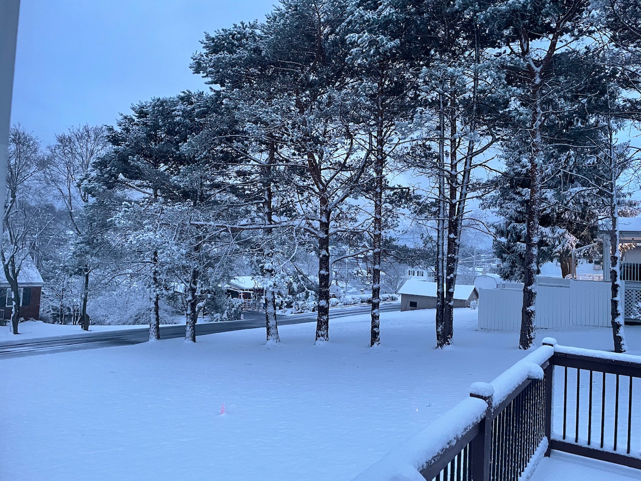
The obligatory daybreak snow pic

-
8
-
-
I’m out of the snow now over here, only about 2.3” total.
-
1
-
-
Temps down to 32ºF and moderate snow. Accums starting on the grass.
-
1
-
-
Snowing in State College on the 511 cams. They also show the road caving already in the 7 mountains region east of State College on US 322.
Really wet snow falling here, not accumulating yet. Temp/dewpoint down to 35/33ºF.
-
The really heavy echoes have gotten overhead here. Mixed rain and wet snowflakes and 38ºF/34ºF
-
1 hour ago, Blizzard of 93 said:
I’ve seen CTP refer to the HREF
Referenced in their 1109pm update.
Quote.NEAR TERM /THROUGH TUESDAY/... Latest model guidance continues to back up the significant southward shift in expected snowfall from the upcoming storm over all but perhaps the Lower Susq Valley. Light rain has overspread much of Southern PA as of 03Z in developing warm advection ahead of the approaching surface low, which is centered over extreme Western Virginia. Model consensus tracks the deepening surface low eastward to the Southern Delmarva Peninsula by 12Z, placing the southern half of Pennsylvania in the bullseye for the heaviest precipitation associated with fgen forcing just north of the mid level low track. Model cross section analyses are also indicating a good instability signature between 11Z-14Z Tuesday over the Lower Susq Valley, with a layer of negative EPV located in the layer just above the frontogenesis. This supports the potential of an intense band of snow with 1-2 inch/hour rates for the morning commute. Model consensus continues to support a north to south changeover from rain to snow late tonight night across the southern half of the state in association with dynamic/evaporative cooling initially, then cold advection on the northwest periphery of the exiting low. The 00Z HREF and oper model soundings indicate the rain/snow line should clear the southeast corner of the forecast area by 11Z. -
Okay better late than never. My one and only call map wise. This is a major change from what was in my head 24 hrs ago. Stayed a little bit generous on northern edge in case things trend up north a little bit better in the very near term. Straddled the 3” line near the M/D line. Toned down top end as well, though there could definitely be some 8”+ amounts scattered anywhere in the red area.
-
4
-
2
-
-
40/31ºF here with a little bit of light rain/drizzle. Light NNE breeze.
-
HRRR has quietly been involving a lot of the Mid-Atlantic folks from DC north with solid accumulating snow today, especially the newer runs. I think that’s rather ambitious but shows how far south this things have shifted heavy snow swath the last 24 hours or so. Those folks gave up on this event days ago.
-
1
-
-
Still warned here.. for 2-4” haha. Not sure I’ve ever seen that before other for additional snowfall on an already ongoing event. These are 6” counties for warning criteria.
QuoteURGENT - WINTER WEATHER MESSAGE National Weather Service State College PA 548 PM EST Mon Feb 12 2024 PAZ019-024>028-045-131100- /O.CON.KCTP.WS.W.0005.240213T0500Z-240213T1600Z/ Southern Centre-Cambria-Blair-Huntingdon-Mifflin-Juniata- Southern Clinton- Including the cities of State College, Johnstown, Altoona, Huntingdon, Mount Union, Lewistown, Mifflintown, and Lock Haven 548 PM EST Mon Feb 12 2024 ...WINTER STORM WARNING REMAINS IN EFFECT FROM MIDNIGHT TONIGHT TO 11 AM EST TUESDAY... * WHAT...Heavy snow expected. Total accumulations of 2 to 4 inches. * WHERE...Portions of central Pennsylvania. * WHEN...From midnight tonight to 11 AM EST Tuesday. The heaviest snow will likely fall before dawn, with snow tapering off in most locations by around 8 AM. * IMPACTS...Plan on slippery road conditions. The hazardous conditions could impact the morning commute.
-
5 minutes ago, Bubbler86 said:
I was joking about DT's penchant to always crown the Euro.
Rain has commenced here. 48/44
Always got to give the hat tip to the Euro haha. If the current Euro depiction were to come to fruition the real winner is the Canadian/RGEM. That’s the kind of solution it constantly showed while the other globals including the Euro had the bigger swath of totals. Never really has embraced the big totals even now, though it has warning totals well east of C-PA. I dunno.. event’s got to occur first. I don’t plan on crowning ANY model for this one, but it certainly wouldn’t be the Euro if I did.
Meso models are going to handle the FGEN induced band of snow better than the globals at this point. I’d be surprised if there wasn’t at least a 4-6” swath coming across. Things can stop shifting south and tightening though, I never really thought I’d be in danger of being out of this event back this way (Altoona/State College region) but wow we’re there right now according to a lot of guidance. Lighter rates outside of the main FGEN induced area of heavy snow are going to be hard to get accums going coming into this event warm.
-
1
-
1
-
-
5 minutes ago, pasnownut said:
my concern is the speed of the storm as we lose a good chunk of white qpf to warm thermals and waiting for transfer. 1-2 hours off and boom becomes bust for some of us southers.
The progged evolution of the low has appeared to change some. Might not be truly one but it’s more of an A look than a B look now with the low mostly just going right to the coast and deepening pretty far south of PA instead of a distinct primary trying to cut thru WV towards western PA. That’s what really cuts QPF and really sharpens the gradient on the NW side of the storm in western/north central PA. It also is what now puts the whole Sus Valley back in the game. Said yesterday the dynamics are there to snow whereever in PA that swath decides to set up, irregardless of elevation. There’s going to be intense rates in that banding. It is going to be moving pretty fast either way.
-
1
-
-
Boy if we see this all the way through with where things are at currently this would be one of the biggest shifts south in the short term I’ve seen for around here anytime lately. Some of that high res guidance suggests several of those northern most warned counties don’t even see a flake of snow and folks like atomix and 2001kx are right on the edge.
-
2
-
-
And to think we started the day ready to crown the ICON for being right having the heaviest snow all the way up along the NY southern tier lol.
CTP was smart to keep their remaining watches up.
-
5
-

Central PA Winter 23/24
in Upstate New York/Pennsylvania
Posted
You’ve done it now, I’m using math haha. Trying to see how Pivotal calculates it’s Kuchera vs WB. So, basically it applies an equation that uses the max temp in the lowest 500mb. In this instance the warmest temp is the surface temp.. which according to the NAM holds at 31ºF for the event.
Applying that equation using the surface temp (31ºF = 272.594K) yields a 9.13 to 1 ratio via Kuchera. Right around its output and also <10:1. WeatherBell’s output is greater than 10:1 so something different is being calculated, whether they don’t use temps right at the surface or maybe they’re applying the bottom equation for all temps, which technically would be wrong. To simplify, the bottom equation is used for the max temp being less than or equal to -2ºC. Plugging that same temp for MDT (about -0.5ºC) into would give about a 10.5 to 1 ratio. Interesting, maybe the codes cracked on that. That would definitely make a difference in map output with marginal temps.