

MAG5035
-
Posts
5,718 -
Joined
-
Last visited
Content Type
Profiles
Blogs
Forums
American Weather
Media Demo
Store
Gallery
Posts posted by MAG5035
-
-
Regarding the Feb 11-12 potential event, ensemble support for the GFS op isn’t there currently on the GEFS.. neither on 12z or the new 18z. Seems like the ensemble mean is more supportive of the Canadian type solution which had one system and no follow-up. 12z Euro EPS did have some signal for a follow up wave.

The follow-up wave scenario behind the likely rain event a couple days prior is probably about the only option to score in the pattern we’re going to be going into thru at least mid-month. Most guidance is putting the MJO into the warm phases in this timeframe. With that in mind, pattern is likely to continue to ensure that cold intrusions behind systems are fairly brief. So windows to line something up are smaller.
-
26 minutes ago, Bubbler86 said:
A rumor surfacing that the GFS was adding in the effects of the Chinese Spy Balloon, and eventual rocket propelled missile that will take it down, into its panels.
Man you beat me to it, I was getting ready to post that the play by play crew didn’t mention the models were incorporating special obs data that I’m sure it’s providing haha.
QuoteThe suspected Chinese high-altitude surveillance balloon flying over the continental US entered the US airspace “due to force majeure,” a Chinese Foreign Ministry spokesperson said on Friday, confirming the airship was from China.
“It is a civilian airship used for research, mainly meteorological, purposes. Affected by the Westerlies and with limited self-steering capability, the airship deviated far from its planned course. The Chinese side regrets the unintended entry of the airship into US airspace due to force majeure,” the spokesperson said in a statement.
“The Chinese side will continue communicating with the US side and properly handle this unexpected situation caused by force majeure,” the statement added.
-
 2
2
-
-
Temp/dewpoint is down to 14ºF/3ºF this morning. Arctic frontal passage delivered a light dusting of snow and gusts up to 30mph overnight.
-
 1
1
-
-
20 hours ago, brooklynwx99 said:
I think CC really just serves to increase variance. we've been stuck in Ninas pretty much since 2015-16 (5 in the last 7 years), and those will dump troughs into the west and try and force a SE ridge, so it's no surprise that the MA hasn't done well, especially when CC is involved. however, once we flip back to a general Nino base state, which may occur next year, I would expect the same kind of anomalous weather as the West has been seeing. there's no reason to think otherwise
looking at the last 6 years from Dec-Feb, we can see all of the anomalous cold has been dumped into the NW US and Plains, which is what Ninas usually do. once we flip back to a good stretch of Ninos, I wouldn't be shocked to see the anomalies flip more to what we saw from 2009-10 to 2014-15, where much of the cold was in the E US with warmth over the WC
so, overall, I do think that the band will snap the other way, so to speak, over the next year or two. would make little sense for it not to. it's also a bit of people trying to rationalize a shitty stretch of winters, when in reality, they just happen sometimes, and we've been tremendously spoiled over the last 10-15 years. it's not like the earth has profoundly changed in the last 5-10 years... CC doesn't act that quickly
Well long post alert haha, I started with responding more about the current pattern we’re in and ended up getting into some other stuff I’ve been seeing posted about in here recently as well.
Has there been much discussion about the PDO among the ones that discuss the overall pattern? Like a lot of people I’m sure, I’m of the opinion that the Pac has been in the driver’s seat the last several winters in our neck of the woods for good or for bad via the EPO/WPO/PNA. Not an expert in this realm by any means but I have been kind of considering and looking into that more as it’s likely a significant driver of the mid-latitude Pacific pattern and one that can have an effect over multiple winters.
NationalCentersforEnvironmentalInformation(NCEI).thumb.png.72fcdda97908427d0a57a528358d71c7.png)
It’s shifted notably into a negative phase the last few winters, coupling with the persistent La Niña state which already implies SE ridge in the standard La-Nina pattern. Throw in the fact that SST in the Pac have been quite warm overall with respect to normal and also how warm the Gulf of Mexico and western Atlantic have been as well and it becomes somewhat obvious to a degree that “on paper” SE ridging could be a persistent problem for snow prospects on the East Coast with that combo. Specific to this winter, I also think we’ve simply been unlucky having the cold air available aside from very brief shots. Record breaking cold in Siberia and northern China during a portion of last month for example is often an indicator of the bulk of the real cold being on the other side of the hemisphere. Canada was void of anomalous cold or even normal cold to press the southeast ridge when we had a suppressed Pac jet slamming southern Cal and the SW states for the first half or so of January.
To add to your point with the 2009-2015 period, comparing SST patterns to the last two truly cold winters (13-14 and 14-15) was interesting. The PDO reversed to positive during that period starting early Jan 2014.
Day to day comparison 2014 vs this year

2015 vs this year

Both 2014 and 2015 had the pronounced +PDO signature and both had a warm western Atlantic with 2015 looking very similar to this year being especially warm and 2014 had fairly similar SSTs in the ENSO realm. Big difference is the warm SSTs pooling along the western NAMER coast (esp 2015) in the Pac coinciding with the dominant ridging being setup in that position allowing cold air to dump into the eastern US. This year the warm SSTs are in the central Pac all the way up to the Bering Strait with cooler waters along the west coast (-PDO signature). Would seem to favor the off coast Pac ridging and western/central CONUS troughing we’ve been seeing as the dominant look so far this winter. It should be interesting to see what kind of an ENSO response we end up getting for next winter and if we continue to have a solidly -PDO. It seems our recent Nino episodes come with this index being fairly neutral or positive while Ninas couple with it being negative.
Underlying factor in these SST patterns is of course that it averages a good bit warmer as a whole than 20-30+ years ago and especially so in the last 10 or so. It’s a reality on data and observations regardless of one’s view of how much CC ultimately is affecting our sensible weather in the short/intermediate timeframe. Even folks like JB, who is heavily analog driven in his forecasting approach, acknowledge this when applying older analogs to construct a forecasting idea. I saw some posting in here recently about the Ocean Heat Content, which looks like this:
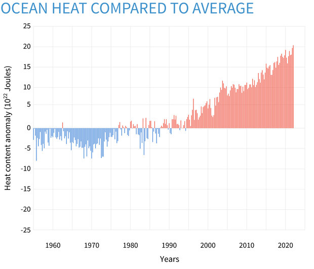
That’s graphing the anomaly of the oceans as a whole, while this shows specifically where heat gain/loss has been taking place in the last 30 yrs.
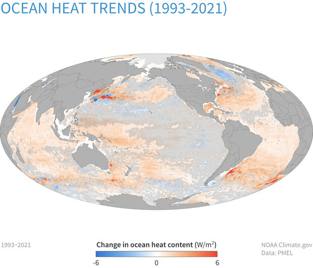
The Atlantic and the western Pacific around Japan are the two big areas of gain in the northern hemisphere. That can ultimately have implications to our weather patterns here. How much so is the debate, there’s a lot of different variables at play even with that basic reality. I tend to agree that it’s more of a variance thing right now. In the context of a Mid-Atlantic winter I think the point some are trying to make is it’s making the difference of seeing a winter with a base crappy pattern that still delivers a couple events vs said crappy pattern not delivering anything at all…which is certainly a viable point. Of course the counterpoint to that could be when you line up a favorable pattern/setup you have a 2009-2010 or 2013-2014 type run or a Jan 2016 type one timer historic storm, and it all happens in a 5-7 year stretch like that did fairly recently.
-
4
-
 2
2
-
-
7 hours ago, Atomixwx said:
Picked up about an inch overnight.
I will assume I am the "haves" of this subforum and I can promise you, I'm probably nowhere close to 50% up here.
I have seen some bad winters in my time between living in the Ridge and Valley Huntingdon, the Cumberland and Lower Susquehanna valleys, and now whatever you want to call this place I live now, but this one kinda beats all.
I'd probably be raging hourly on Blizz's optimism and calling him a wishcaster at this point if I still lived in Palmyra.
Sent from my motorola edge 5G UW (2021) using Tapatalk
Not like we’re setting a high bar with this comparison or anything but 2019-20 was the worst and this one’s already a couple inches better than that one was here. I didn’t have a single snowfall over like 2.2” in that winter. At least this winter has some part of the subforum with some kind of “haves”, which it seems in comparison to average the UNV region has fared the best. UNV at 19.9” is only 2” below normal for the season to date.
-
1
-
-
52 minutes ago, Rd9108 said:
Our last foot storm was in March so I'd say that even though winter maybe coming to a close for "coastal" areas, places like Central and Western PA still have plenty of time to score a storm. I've seen snow in the beginning of May here. Only thing that sucks is it doesn't stick around usually.
It’s looking pretty snowy over there on the 511 cams tonight speaking of which.
-
1
-
-
2 hours ago, TugHillMatt said:
Just a "little bit" behind here in the Syracuse area. The 4th absolutely pathetic winter for here in the "snowbelt." This one has by far been the worst. They just keep getting crappier.
Wow I didn’t realize Syracuse was in that bad of shape. What about Watertown? I’d imagine they’re running well above normal being a SW flow recipient off of Ontario. It illustrates the lack of NW or WNW flow setups we’ve had during favorable LES periods this winter, which I’ve felt has seemed to be more of a thing the last several winters. The Laurel’s down here benefit from NW flow when it comes to LES, which I’m sure C-NY does when it comes to non or post synoptic snowfall. I did make a post about this earlier this winter but the Co-op site on Laurel Summit, near the 7 Springs resort has had one average winter since 2013-14 with the rest of them being below average.
That includes 2014-2015, which was the last truly consistent cold winter we’ve had in recent winters when it came to the heart of the winter.
-
4 hours ago, canderson said:
MAG basically just cancelled winter in his professional, expert language.
Save for some dumbass March storm that melts in 12 hours it’s probably time to think about garden plans.
I guess I should clarify that in no way am I “cancelling” winter or any prospective winter weather pattern beyond the next couple weeks lol. I’ll talk longer range stuff to a point but I usually focus on things inside of 2 weeks or so. I was basically saying I’m gonna call a spade a spade when it comes to an upcoming pattern that doesn’t look great which well.. it doesn’t.
However, that doesn’t mean we’re going to shut the rest of the winter down… or even the rest of February for that matter. Trying to determine pattern progression beyond the operational model range (8-15 days) is never any kind of a sure thing. Which if I’m being honest, neither is the back half of the operational model range a lot of the time. Rolling with a presumed continuation of the seasonal trend (SE ridge/western trough/limited available cold) is all fun and games until it isn’t. The MJO, for example, still has to move out of Phase 3 where it’s been stalled the last several days. While most modeling progresses this into the warmer phases it’s certainly not known how much or how long it progresses into part/all of the 4-6 realm or at all.. because we’re not there yet.
I consider March very much still a part of winter, some of our bigger recent snow events have come in that month such as in 2017 and 2018. Cold patterns can still be notable and have some staying power, especially during the front half of the month.
-
4
-
-
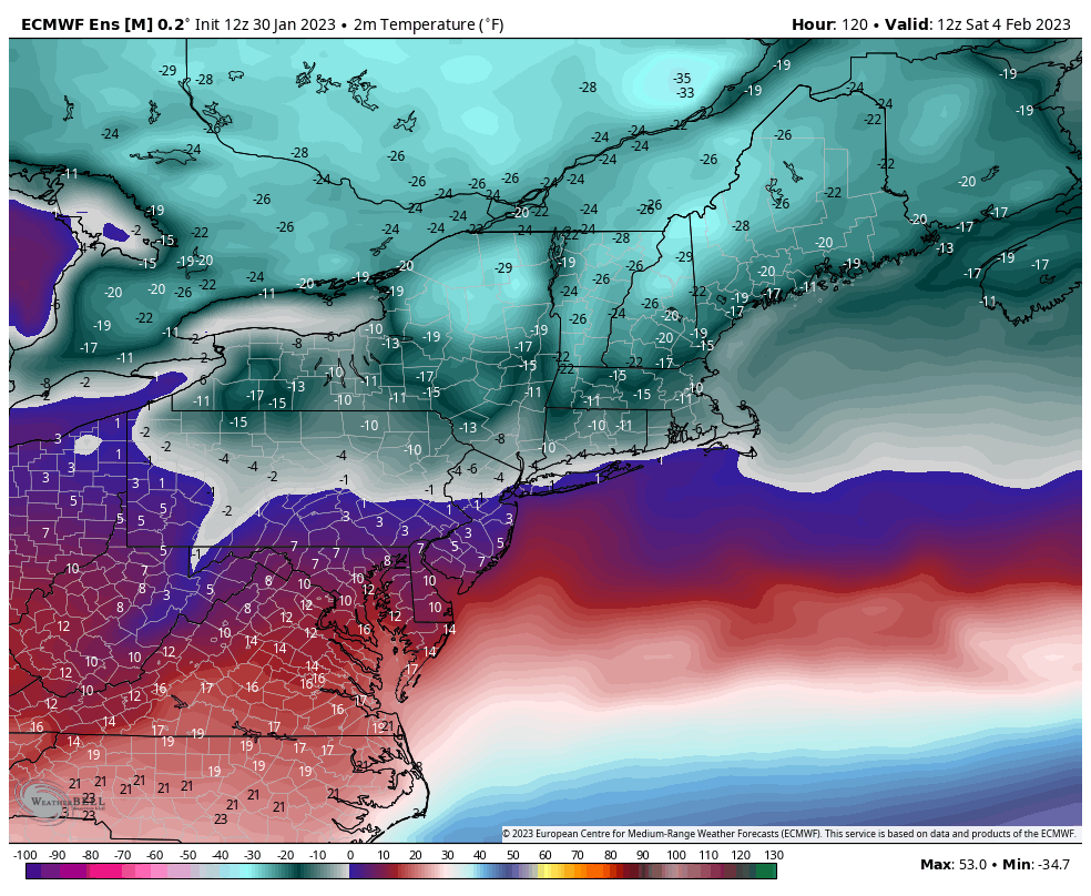
Mean 2m temps ( in ºF) for 12z Saturday via the Euro ensemble mean.
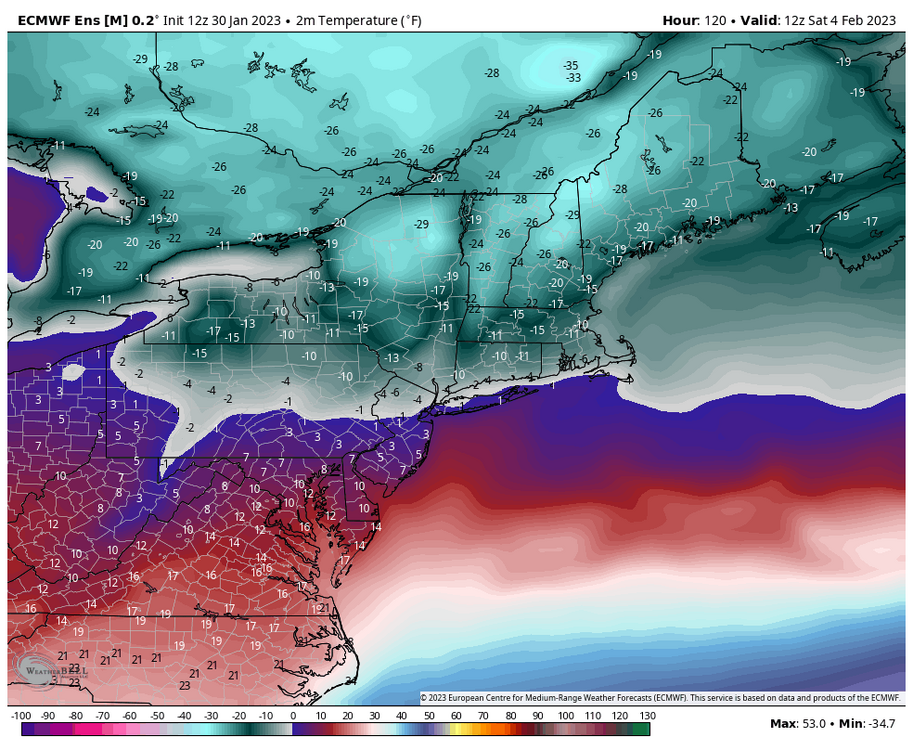
The Euro suite has been the coldest guidance in terms of pressing the arctic air south, but both it and the GFS have below zero temps in northern PA and at least minus teens in that Bradford/Smethport region of northern PA, which I suppose could be considered PA’s version of Barrow, AK. Fortunately the worst of the airmass doesn’t directly target our region, and fortunate I guess if you don’t like extreme cold that we are likely to not have any kind of established snowpack of consequence. If we did have one, I could see this being the type of thing that could challenge daily record lows via ideal rad cooling. Euro tries to get NYC below zero. The fact that’s even on the table in a snowless winter to date there is pretty brutal. At any rate, this is a very brief shot that settles in 2nd half of Friday into Saturday. It’s likely to be quick enough that we’ll have non-diurnal temp rises overnight Saturday into Sunday as the glancing arctic air mass moves on.
Beyond that, I really don’t have anything positive to report on the winter prospects for a period of time TBD (certainly the D8-15 range that gets into the mid-month timeframe). I mentioned a couple weeks ago the MJO was probably going to have a hand on where things go mid-late February after the end of Jan/first week or so of Feb. Since then, it finally emerged into Phase 3 where it currently resides. Forecasts had been mixed on whether the MJO pulse would fizzle there back into the null phase or go on the 4-5-6 tour and as of late it appears the latter option has become a better consensus.. certainly getting it into 4 at the very least. How fast it gets out of that realm (if it gets there) will play into any kind of attempt of a pattern reshuffle later in Feb.
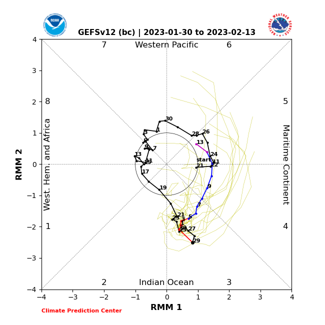
NCEP bias corrected guidance (GEFS)
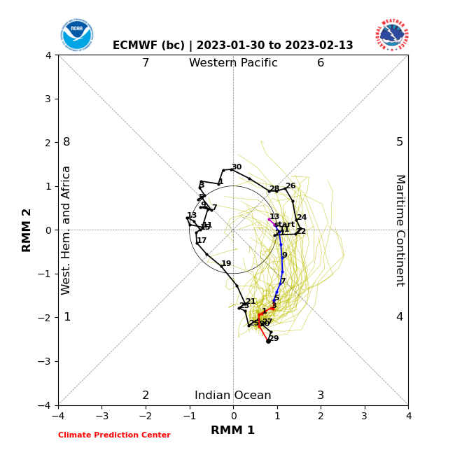
Euro bias corrected:
To add to all that, we reverse the -EPO we finally got to a +EPO and run a persistent +AO/NAO and continued -PNA through the period. The former (NAO/AO) retracts true arctic air poleward and the latter (PNA) implies continued western troughing. It looks like a lot more of a traditional +EPO Nina setup. I’m never gonna say winter’s over on Jan 30 but I’m not going to pull any punches when I see a period I think has a high chance of sucking either. Really needed this weeks active southern branch pattern with available cold to produce… which I mean still could to a degree I guess if we can somehow get a piece of something into southern PA. I honestly like the DC folks’ chances better to score something provided they have cold enough temps to snow. Either way, I don’t see anything in the caliber that this setup COULD have produced for our region.. just no interaction between northern and southern branch.
-
4
-
-
Another week of wasted opportunities seems to be in the offing this week as we eventually settle into a seasonably cold regime this week after the weak system today into Monday. Split flow with an active southern stream should be a recipe for some success with some cold available for a change but models have been generally insistent on not even partially phasing anything enough to bring precip into our region and keeping these southern stream systems in pieces and disorganized. I do think that Feb 2-4 period still has the best chance at maybe getting something up here with that particular wave.
Lost in the spring fling in here and what may squash that particular wave is a very brief but significant arctic shot on the models next weekend that glances C-PA but targets the interior northeast directly with some -30ºF and less ACTUAL temps Sat morning in far northern Upstate NY and interior New England. Euro is a bit more widespread into PA with the arctic air and barely gets much of PA into the teens during the Saturday. GFS is warmer but still much chillier than what CTP has in their grids. Both have below zero temps to start Saturday in at least the northern half of PA. I’d imagine they may want to consider bumping down temps in their grids in that parcticular time period.
-
3
-
-
Have about an inch of new snow so far this evening from the LES/upslope snows and occasional bands that have had success getting off the Laurel’s tonight.
-
3
-
-
8 minutes ago, pasnownut said:
Heres my beloved NAM from last evening. Solid bust to the s/se sides and we may have a little more snow left to come. IMO the GFS did a decent job w/ r/s (like RGEM), but I've not seen a map posted that looks really close down our way. Guess that add's to the blended approach that we sometimes need to take.
That tropical tidbits map that includes sleet with the snowfall makes the 3k NAM look halfway competent with this event. It was showing less than 1.5” south of I-80 in almost all of central PA on model sites that separate that out as recently as 6z this morning. The 12z run still didn’t even pick up on any Sus Valley snowfall, even in Harrisburg.
-
Dry slot is here and 3.5” is the total. Never mixed either, so the other stuff can stay away until it’s cold enough upstairs again later tonight and tomorrow haha. Melting down my rain gauge collector inside to see if I can get a rough ratio on the snowfall.
-
1 minute ago, paweather said:
GFS and Euro for the win! Mod snow 1"
GFS for sure if Cashtown’s saying he has almost 4”. That was about the only model that was consistently showing that kind of snow that far into the LSV while keeping the widespread advisory totals in the rest of central PA.
-
1
-
-
Moderate snow and 29ºF, winds are up some as well and the flakes are a little bit more rimed. The mixing line is very close, but so is the dry slot.
3.2” now with 0.8” in the last hour.
-
2
-
-
1 minute ago, canderson said:
I don’t see any snow angels lol.
11 minutes ago, Newman said:Whoa snow is really coming down here at Millersville. In 5 minutes it went from nothing to moderate. Coating already on everything, so finally measurable on the board! I hope I'm wrong and we have a positive bust today!
Radar and snow obs into Northern MD should make for a pretty good chance to get that 1”+ there and keep the Feb 4, 1995 record for latest 1”+ of the season at bay.
-
3
-
-
Moderate snow and 29ºF.
Measured 2.4”, making 1.5” in the last hour.
-
4
-
-
3 minutes ago, Atomixwx said:
Ripping snow.
Sent from my motorola edge 5G UW (2021) using Tapatalk
Same here, it’s piling up pretty fast. I started with nothing on the ground.

-
3
-
-
0.9” one hour into the snow here. Moderate to heavy rate and 28ºF. It’s actually a pretty dry snow so far too.
-
3
-
-
6 minutes ago, pasnownut said:
looking at intellicast radar, its nice to see blues hangin on below us. Not saying a big surprise is in order, but as alluded to for the last couple days, ever hour we can hang on will help.
I still think it’s going to snow everywhere in the LSV on the front end, there’s snow being observed all the way into northern VA. Even with surface temps a couple degrees above freezing the column should wet bulb down. Biggest question mark is York/Lancaster and how much can get on the ground if it starts as snow. Think the biggest thing there is if the best rates go north of there initially. Otherwise Harrisburg area looks good for getting to the 2” advisory threshold IMO. The stuff over here started fast and has stayed pretty heavy.
-
2
-
-
Snow has just commenced here, 30/24ºF.
-
3
-
-
511 cams showing it snowing all the way to the WV state line on I-79 in SW PA with grassy accums starting, with the highway caving about 15 miles up the road in Waynesburg. The 6z 3k NAM and RGEM already looking pretty bad there (had 0 snow in SW PA). Will have to see how that translates to the Sus Valley when the precip gets there.
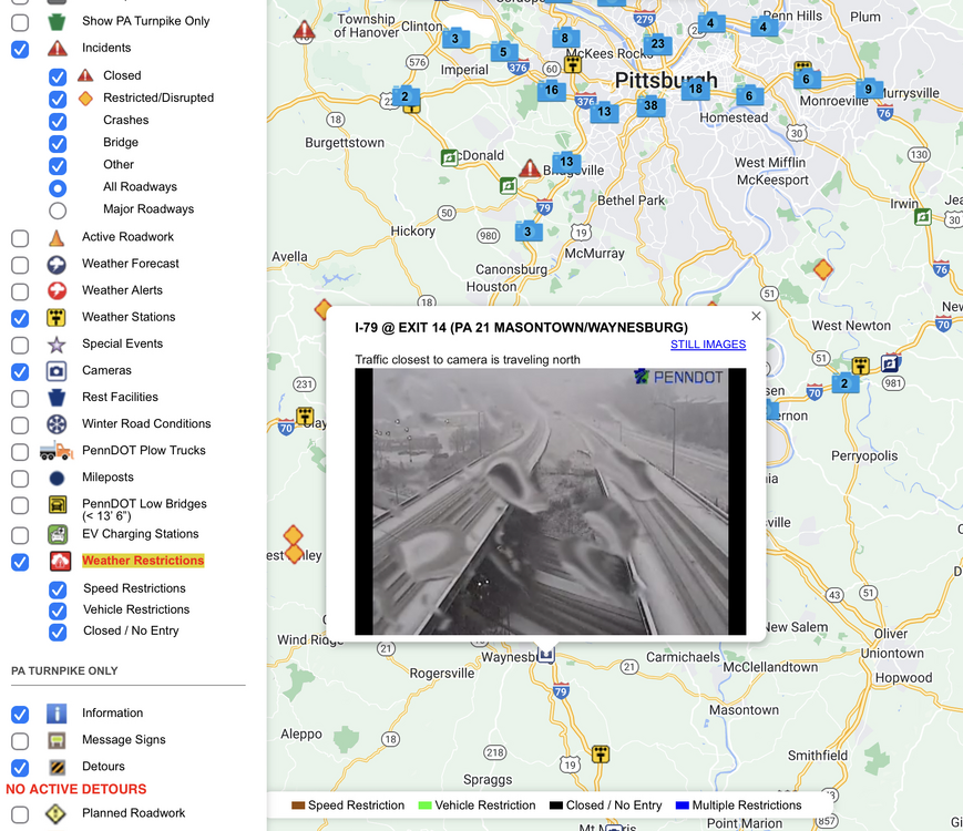
-
2
-
-
Despite a good bit of virga so far, I think upstream radars (I’ve been watching PIT and Charleston, WV) are looking okay. The stuff that is likely reaching the ground is crossing into SW PA now and that is a couple hours sooner than what the HRRR has been showing as that has been suggesting a mid-late morning start in C-PA. There are some mPing snow reports north of Pittsburgh as well, so PIT radar is indicating the atmosphere is moistening up. I think the HRRR might be under modeling the precip shield a bit.
The short range/high res models have been really inconsistent among themselves and still are with the snowfall swath. I’ve personally tossed the NAM and RGEM and favor the HRRR as the short range model for the snow swath positioning. With the globals I still think the GFS is too generous in the southern tier but the 6z Euro looks pretty close to what I’m thinking and also jives okay with the HRRR swath (Euro a little bit more solid). I also think CTP has a solid snow forecast out right now. The reality with this is that the ceiling has lowered with regards to high end amounts, thus their decision to go all advisories.
-
3
-
-
19 minutes ago, Rd9108 said:
Sheesh might be a non event here when it's all said and done. I guess just hope for a bust.
Most guidance has been supportive of at least a couple inches generally from the metro north, which I’d feel okay about. The big question is the south of the metro and how much warm advection precip can actually manage its way up into the rest of SW PA early, like especially prior to and near 12z. It’ll snow anywhere if there’s a more expansive precip shield that gets into PA early enough.
Even without much of that, the main part of the system with the direct southerly flow straight from the Gulf of Mexico could still yield a start as snow with pretty heavy rates even in further SW PA but obviously time would really be limited there before the column temps get routed and then the dry slot arrives.
-
1
-

NationalCentersforEnvironmentalInformation(NCEI).png.baa84974818d1eec45465668e9566a3b.png)


Central PA Winter 2022/2023
in Upstate New York/Pennsylvania
Posted
Been pretty breezy here too, especially late afternoon. I had a max gust of 48 mph for the day just after 4pm this afternoon and a couple other 35-40mph type gusts here and there. Temp/Dew is down to 10.8ºF/-4.6ºF now.
Speaking of shingle shredding winds, the obs up on Mount Washington observatory are insane this eve… as is their weather discussion. -45ºF with winds of 90 mph, G to 106 currently. Good for a minus 105ºF wind chill with the sustained wind.
Their discussion: