

MAG5035
-
Posts
5,884 -
Joined
-
Last visited
Content Type
Profiles
Blogs
Forums
American Weather
Media Demo
Store
Gallery
Posts posted by MAG5035
-
-
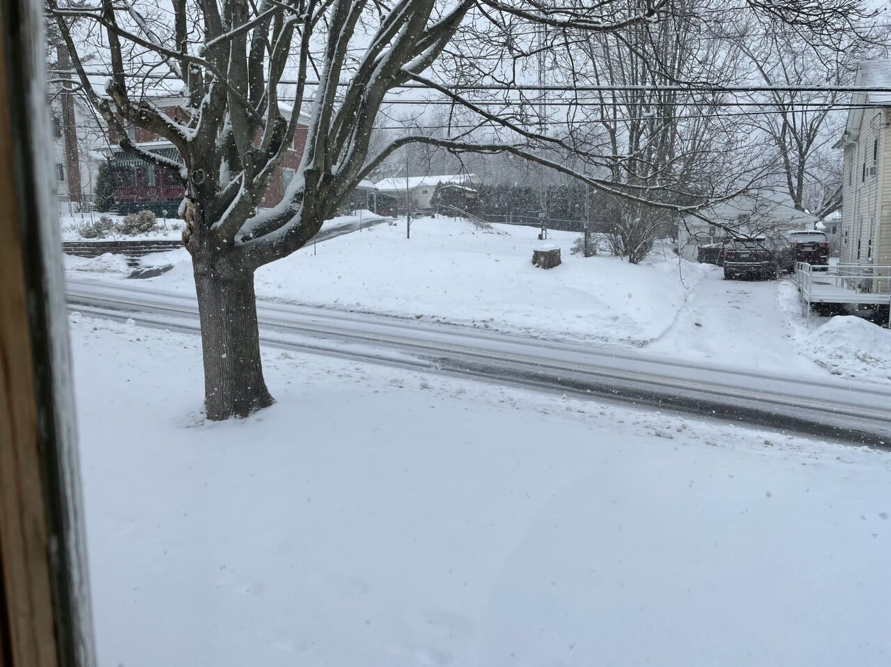
Final total was 1.4” I measured very early this morning. There was a nice little fluff band around 3-4am that added the extra. Temp is only 16ºF currently with a dewpoint under -6ºF, certainly a sign of an actual arctic airmass in place. Will have to see if I can get my 3rd below zero low this month tonight, the wind might keep that from happening.
Well today’s Canadian and especially the Euro perfectly illustrate my point yesterday about not sleeping on that late week storm. Heck the Euro has 6+ of snow in a large portion of PA along with the ice referenced above.
-
 1
1
-
-
Still some light snow blowing around here. I did reach an inch for this event. Temp 17ºF.
-
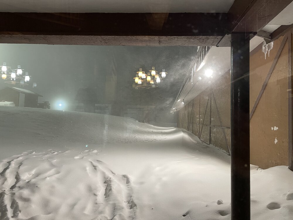
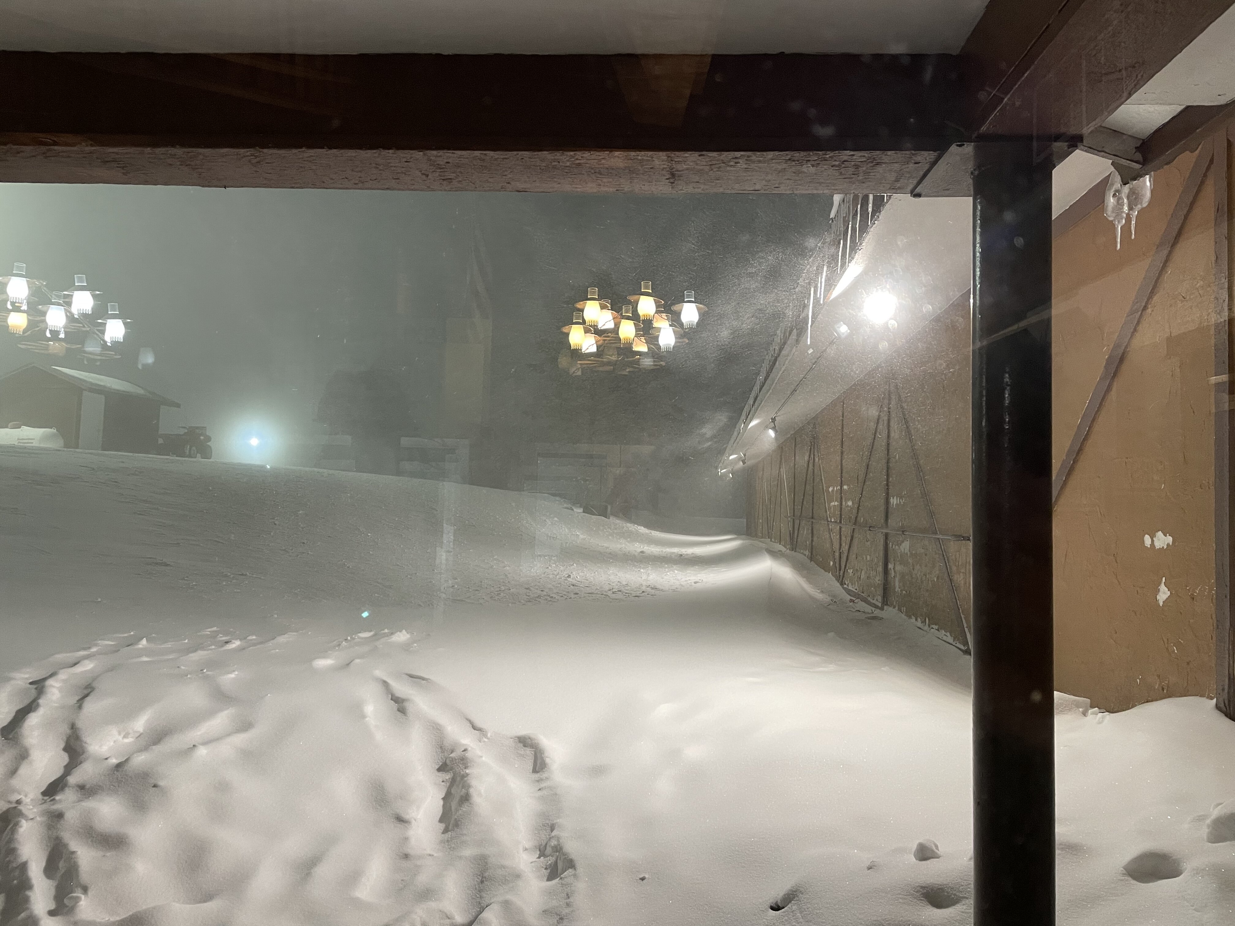
Finally back into some snow falling, and this snow globe has bigger flakes this time lol. Should have some better luck accumulating if this patchy snow sticks around for a bit. Surfaces like the cars and the deck were frozen back over by dusk and temp is back down to 26.6ºF.
-
Some additional thoughts going forward… I wouldn’t completely sleep on the next bigger weather system slated late next week being just a straight up big warm up and rainmaker… especially in the more interior portions of C-PA but even region-wide too.
First feature of note is mid-week a pretty strong low is slated to track well north of the Lakes and tries to drag a frontal boundary which is likely what the main system will run on. Euro seems more concise with one main wave and GFS a bit drawn out with an additional wave running that eventually pulls the cold boundary and turns a lot of C-PA to ice and frozen just prior to fresh arctic air blasting into PA . There’s also a lot of cold and high pressure on the playing field. While main focus in terms of the strongest high presses cold more into the Central/Mountain West US via a western trough that briefly develops in the western US.. there is half decent high pressure present modeled to our north. Given the range, the globals don’t generally see the CAD as well so there’s the possibility of a messy front end of the event. Most of interior C-PA has an established pack too. The low tracks are pretty close too, really. The 18z GFS for instance takes the eventual main surface low thru PA while the 12z Euro was up into the Lower Lakes and then up the St Lawrence. Timing and progression are going to be important…wouldn’t take too much in what has been a progressive winter for this to be more progressive and suddenly have us more on the better side of the low. The GEFS currently presents a plethora of p-types (at various timing differences) across all of PA. So I’ll be keeping an eye on that since this is still in the 5-7 day range. With all that said, we are going to experience a moderating trend mid week next week (mainly Tues-Thur timeframe).
Getting further into February, I really don’t see any reason to not have more chances at snow, even though we may have more changeable weather (ups and downs). We’ll continue to go as the Pac goes as the NAO/AO has generally been positive and continues to stay that way.The AO does dip negative for a time later next week, but generally speaking we don’t have an established blocking pattern in that realm. The big keys are the continued -WPO and neutral to negative EPO maintaining that Pac ridge and continuing to provide a cold source region that will continue to push cold air into the CONUS. I was watching the PNA as it is going to go negative some next week, which is why we moderate as ridging builds in the East. This is gonna be nowhere near the magnitude of the -PNA in December and it is forecast to quickly go back into positive territory some.
The other thing I’m watching is the MJO. It is currently in the null phase (circle of death, etc).. basically right now it’s in a position where it’s not exerting a significant influence into the Mid-Latitudes. Which is fine.. the ECMWF pretty much keeps it there indefinitely. The JMA and NCEP stuff eventually get it into phase 3 (still a cold phase) and the NCEP spaghetti plot does show some potential of this to perhaps eventually run into 4 and so forth. With the other regular teleconnections staying pretty serviceable for now (esp on the Pac side) the only thing I really worry about is a new stronger MJO pulse running the 4-5-6 gauntlet… especially in a full blown mature Nina. Something like that would obviously likely ensure our overall chances of winter weather are much lower during such a period. Fortunately, A. That’s not really showing currently, just a concern of mine and B. Even if this were to start showing say within the next 6-10 days it would be probably be after mid Feb before we saw any sensible pattern changes. So going forward, yea we’re not going to win all the storms and probably warm up here and there.. but there remains plenty of cold in the pattern and plenty of chances down the road at least the next couple weeks, IMO.
-
5
-
 2
2
-
-
1 hour ago, paweather said:
Was this storm ever a hit on the models here?
There were a couple scattershot runs in the 8-10 day range that got us maybe, otherwise this thing was a non-event even in most of New England until inside D5 when it finally started phasing into a bigger storm on all guidance. Then once it was seen consistently everything with the coastal was mostly 95 corridor east. As I mentioned multiple times the last few days this northern branch system and frontal wave pressing to phase in was the key to us seeing at least widespread snowfall… which we do have but just not the rates. We rarely do well when the coastal doesn’t start organizing in earnest til it’s off the NC/SC coast (well off it in this case). This needed to start happening in the SE US/Gulf region.
-
3
-
-
Well I’d call it a snow globe out there since late this morning but I’d probably end up returning the snow globe for one that has bigger flakes in it. It’s been mostly a steady light pixie dust with temps steady around 28ºF.
With the fine snow and light rates, the little bit of solar insulation there was has been enough to keep accums off of every non-snow surface except the glass table on my deck and my snowboard… which both somehow have about a half inch of new snow. At least it’s accumulating where it counts (on the snowpack) haha.
-
1
-
-
That 0z Euro run that just dropped has to be one of the most insane runs the southern New England folks have ever seen. The low passes just a hair outside the benchmark and tucks right into the Gulf of Maine.
And I’m sitting here just hoping tomorrow I get 1/42nd of what Boston has on that Kuchera map lol.
-
Well looks like the 3k NAM is a good bit more aligned with the 12k in terms of delivering 30+ to a large portion of SNE now, so there’s that lol. Taunton has to be considering blizzard warnings for eastern Mass. I’d say some place in and around that NWS office or generally in between Boston metro and Cape Cod inland of the coast somewhere would be a great place for anyone wanting to do a snow chase. There’s going to be monster rates/ratios under any meso bands there.
Main difference back our way is the models are starting to go back towards solidifying the initial snowfall breaking out across PA, and a couple like the RGEM are getting the back edge of the actual deform shield from the coastal low into the fringes of the Sus Valley. That was my original vision of how to make this system work for us or least the majority of us since most live the Sus Valley in this forum. Having a decent WAA wave of snow from the northern system phasing in and transitioning some right into the some of the deform when the coastal explodes.
-
5
-
-
2 hours ago, mahantango#1 said:
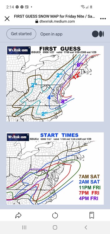
That’s gotta be the most confusing start time map I’ve ever seen. The SE quarter of PA got 4/5 start times criss crossing and whatever snow develops there tomorrow is gonna be starting way earlier than all of them lol.
I really haven’t been a big fan of this storm threat in our region and just figures that it came back west enough a couple days ago to have to acknowledge the possibility. Although, I felt that the best chance of success was going to hinge on the developing wave of snow with the northern system and frontal boundary and if the storm phased early enough that the coastal wave could keep snow going for a time in the Sus Valley and eastern PA and provide a respectable event. The now presumed later explosive development of the coastal mostly takes that away and we’re left mainly with what the initial wave of snow can do, which will be during the day tomorrow. I’ll note that I’m not going to rule out York/Lancaster (and far eastern PA) catching some of the deform shield from the coastal.
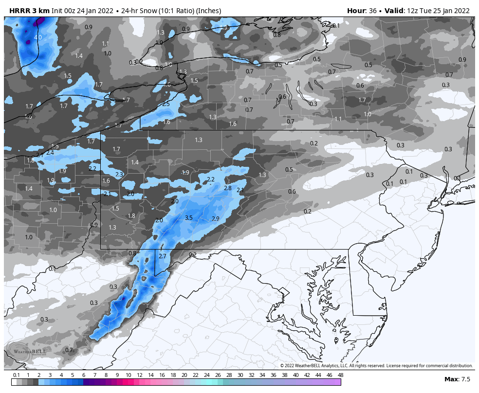
At any rate…. Initially the SW flow makes for the downsloping shadow east of the mountains seen on the higher res models but eventually precipitation does generate further east in PA as the coastal low starts taking shape and you start getting some easterly flow. So there will be flakes to be had probably for most of us late tonight thru tomorrow (west to east) but big question will be how much it will amount to. Models like the 3k NAM, RGEM, and the HRRR do show something, with the RGEM being the best showing a more widespread 1-2” with a bit more in York/Lancaster since it’s been pretty far inside with the coastal. So a general light snowfall is still on the table, but we’ll see how well this northern branch system does. There’s already precip in western PA from it and I’m about to get some echoes overhead (though I’m dry with a 28ºF temp and 9ºF dewpoint)
-
4
-
-
56 minutes ago, Atomixwx said:
Meanwhile in the real world: It's -5°F currently. While not as impressive as the -17°F I experienced picking the girlfriend up at work last week in Houtzdale, still damned cold. This month has honestly given me every bit the winter experience I desire on an annual basis, minus a major, double-digit snow.
Hopefully the rest of the forum gets a nice snow before spring so we all get the fun.
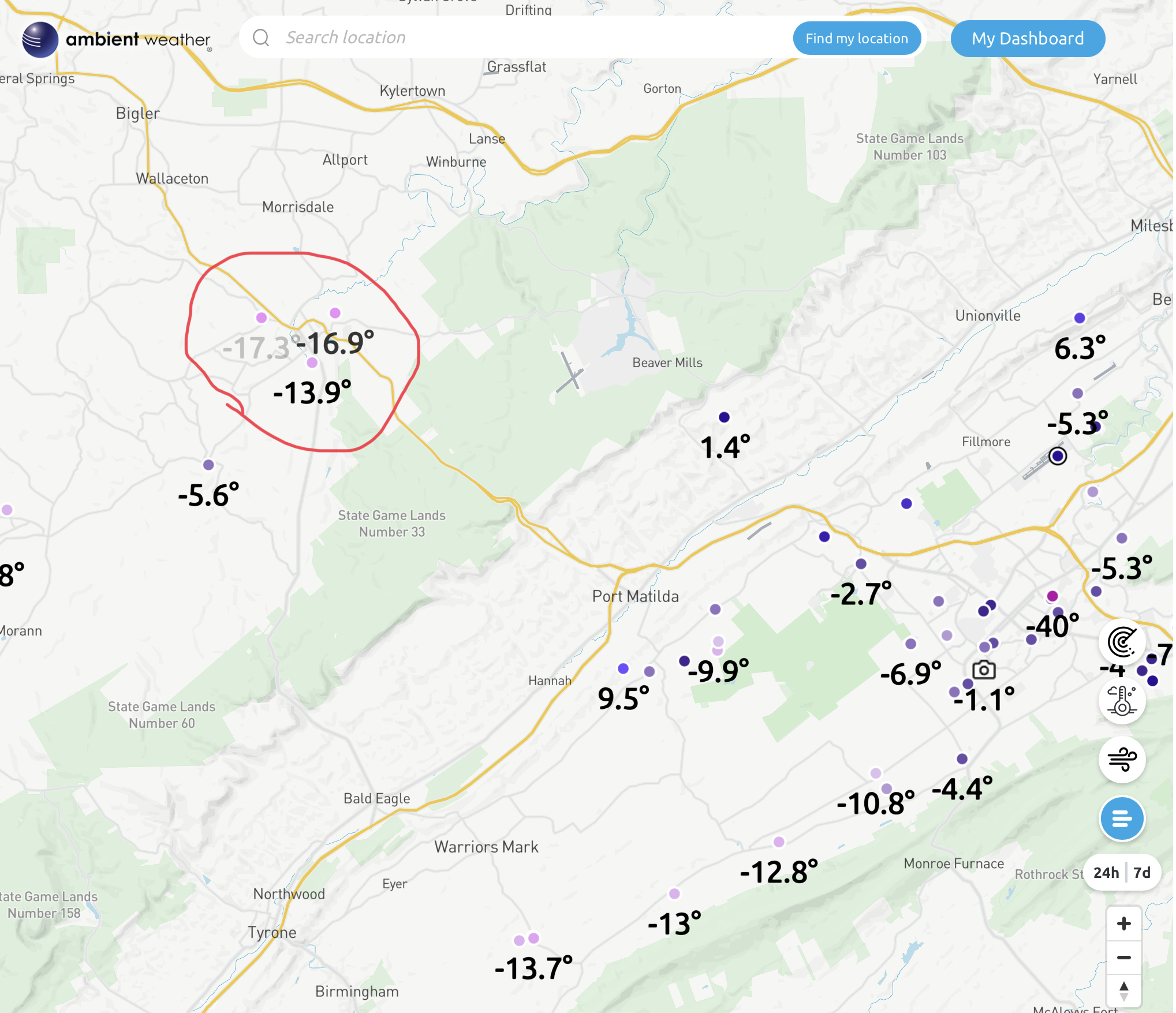
You must be in a hot spot up there haha, there’s three weather stations in and around Philipsburg on the Ambient site and two of them were just recently under -17ºF and the other is like -14ºF. There’s a South Philipsburg one on Mesowest that was -14ºF.
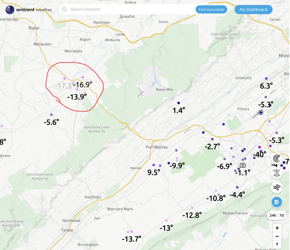
It bottomed out at -5ºF here about half an hour ago, which is pretty impressive for being in town. Still about -2ºF. Impressive cold all up and down the 99 corridor as you can see on the above map and also the Mesowest map below.

-
34 minutes ago, CarlislePaWx said:
Hey @Blizzard of 93!
Look what we have to look forward to after our rain storm next week! This is Day 9-10 where it appears there is a battle going on between the arctic trying to come back in while fighting off the southeast ridge...
Yea the 0z GFS really lined em up in it’s long range. I saw like two other events after that one. I’ve had thoughts about the pattern coming up but had been waiting to get much into it til we saw what this coastal was gonna do. I’ll probably elaborate more tomorrow but generally I think that while this pattern is going to shuffle around next week and give us what looks to be a 2-3 day warmup, I believe at least for now we’ll maintain a regime that’s going to give us chances through at least the first couple weeks of Feb.
-
2
-
-
Bouncing between +1-2ºF so far here in town. Already several meso stations below zero up and down the 99 corridor again much like last Friday Night. There’s a -6ºF near Claysburg (south of Altoona) and a -8ºF near Stormstown (just west of State College).
-
1
-
-
Quite cold tonight here, already down to 8ºF.
-
1 minute ago, canderson said:
The Euro to me is overamped. (Which seems to be a trend)
Well on the other hand, we were sizing up 10+ in all the Sus Valley around the D5 timeframe leading up to the 1/16-17 storm and the end game from that was the 980mb low literally going right over my head haha.
Yea that’s probably not happening with this storm but the Euro take is definitely easily in the realm of possibility, or even closer to the coast than that. It depends on the degree of phasing and how quickly it happens. Additionally, this initial area of snowfall that develops with the northern energy is still showing and I personally think with a major amplification like this that this will eventually start showing better QPF wise the closer we get, provided we don’t see a major setback in guidance back towards what it was showing a couple days ago.
-
1
-
 1
1
-
-
Nit picks aside on it shifting it’s swath east a bit (and south some with the initial snowfall development in our neck of the woods), GFS is still showing the same general theme of bombing the coastal storm out later and further east, only catching SNE with the more excessive snowfall. Euro has been exploding this into a big snowstorm starting much further down the coast. It’s a difference between a more run of the mill coastal with localized major snow (GFS) vs a sure fire NESIS cat 3+ considering how much of the megalopolis is within the 10+ in both the Euro and it’s ensemble mean.
-
1
-
-
The eastern third of PA is very much in the game for direct impacts from the coastal low, and for the state as a whole it may not be the all or nothing proposition it was looking like a few days ago if the coastal ultimately develops too far east for most in here. Models are pretty solid now on showing general snowfall developing across most the state Friday as the phasing northern energy drops down and attending arctic boundary presses. I Mentioned this in two posts on Sunday, even on the first post during the day when the coastal aspect of this wasn’t anywhere near close to C-PA and I was still skeptical on a bigger storm happening at all. If the coastal trends closer like the Euro this setup could help in terms of a more expansive precip shield (even though the axis of heaviest would probably tend to be just east of most of the subforum)
What’s ultimately changed is the timeframe of this phasing occurring (faster). This was really well explained in the Mount Holly AFD that was shared in here first thing this morning. The faster ejection and phase presumably keeps the western ridge axis in a much more favorable positioning for us and not too far east. This is what changed the game with this and now that all the models are on board for the bigger storm happening this could absolutely trend better. We’ve been running a progressive pattern so it wouldn’t be too much to see this speed up a bit more. It also could trend back the wrong way too, let me be clear. The shortwave timing is very important.
At any rate, for any thought of the Euro being over amped the 18z NAM in “guru” range said hold my beer lol. There was a large difference between 12z Euro at 90 and the 18z NAM at 84hr.
-
3
-
-
59 minutes ago, Atomixwx said:
I'm about to build a bobsled real quick and go sliding down Rte 53. If you start in Kylertown, it's a gradual down slope until the red light at 322 in Philipsburg.
Who needs Beijing?
You’d probably get more speed going down Sandy Ridge Mountain from P-burg to the Snappy’s in Bald Eagle lol.
-
Just got home, all roads are pretty rough. Measured 1.5” with moderate snow and 28ºF. Back edge is coming soon but it’s probably going to get to 2” by then.
-
4
-
-
Currently up at Blue Knob summit, the snowboarding was pretty decent this afternoon. Plus got some time in the new snow falling.
-
6
-
-
Well I’m surprised @Blizzard of 93isn’t around tonight with updates haha but there has been a distinct shift in guidance (ops and ensembles) tonight towards this coastal system being a good bit closer to the coast and quite strong as it has been occasionally showing inconsistently on op guidance (mostly the GFS).
Tonights 0z Canadian actually gets the coastal system back into some of the Sus Valley which is roughly supported by it’s ensemble mean taking a developing low off the coast just inside the benchmark. The GFS and Euro have benchmark systems, which also show that approximately on their ensemble means. The Euro (in a massive difference from 12z Sunday) specifically detonated New England with exploding low pressure at sub 960 near the benchmark to an eventual 946mb in the Gulf of Maine.
Despite a few big C-PA hits on a few GEFS and Euro EPS members, the coastal storm is still ultimately too far east for us but this was the kind of model cycle I’ve been waiting to see in terms of collective support among all guidance of some kind of bigger coastal storm and associated phasing. And this is starting to show right around the D5-6 timeframe too, so we’ll see how this evolves. Like I mentioned earlier, what’s also to be considered is even if the coastal misses east is lighter snows from the northern branch wave that phases in to pop the coastal low. That’s also showing to a degree on guidance now as well.
-
2
-
-
1 hour ago, Atomixwx said:
Can confirm. What a snowy day. Roads are a disaster.
We’re probably going to get some kind of repeat of this starting late tomorrow afternoon into tomorrow evening with clipper #2 as well.
New 0z HRRR, and this seemed to do half decent with today’s event.

-
1
-
-
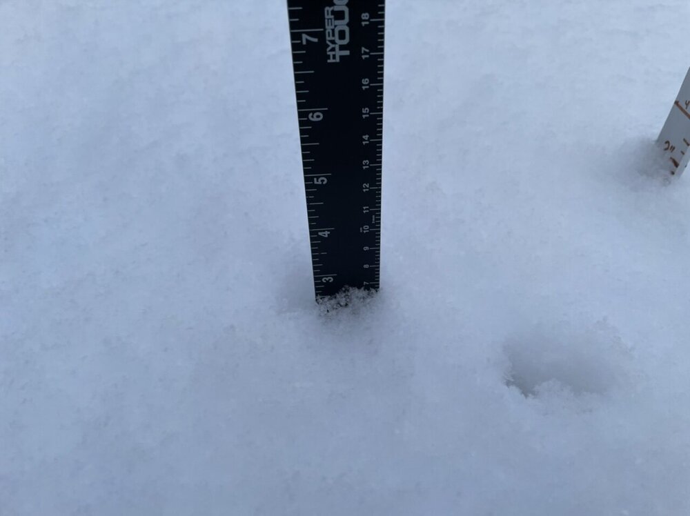
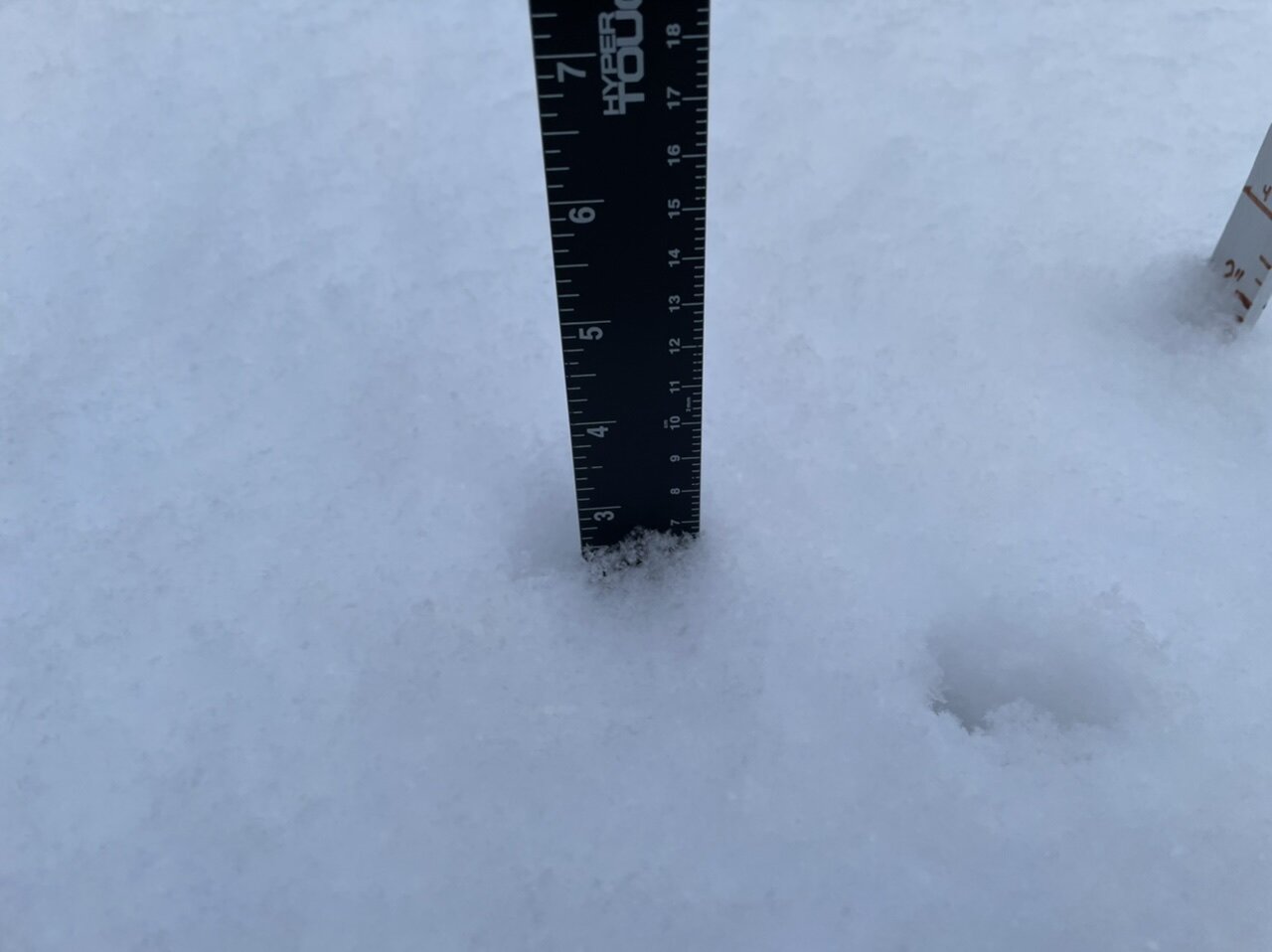
About 2.5” or so with light snow falling. Temp still between 27-28ºF. You can see how fluffy the snow is.
-
4
-
-
28ºF moderate snow. 1.7” now on the snowboard. 2” seems pretty attainable, I wonder if this can squeeze out 3” here. I think CTP should have issued advisories for at least the Laurel’s and maybe even a few of the central counties to match up with PBZ’s expansion of advisories they did overnight last night. If it’s a fluff bomb here at 1300’ it’s definitely one up at 2-3k feet in the Laurels. There have also been some issues on I-99 this afternoon, esp in Centre County.
-
1
-
-
27°F/25.5°F, light SW wind.
Light to Moderate rate currently after having a nice burst for a awhile. Over an inch.
-
3
-


Central PA - Winter 2021/2022
in Upstate New York/Pennsylvania
Posted
Here’s the NOHRSC snowfall for the season to date, which comes with a legend and numbers. Pretty sure this is an estimate derived from model analysis/satellite so the individual numbers at stations might not be what’s officially reported. It’s usually in the ballpark though.