

MAG5035
-
Posts
5,718 -
Joined
-
Last visited
Content Type
Profiles
Blogs
Forums
American Weather
Media Demo
Store
Gallery
Posts posted by MAG5035
-
-
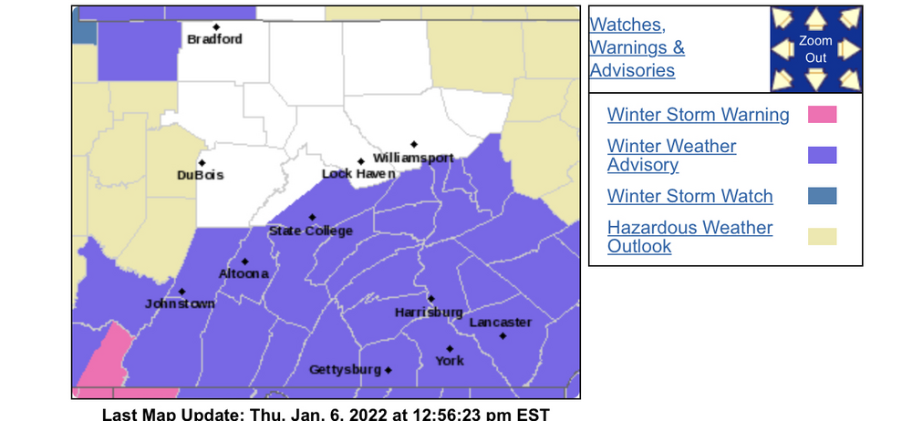
Advisories have been expanded deeper into central PA
-
 1
1
-
-
Where’s our new play by play guru @Cashtown_Coop? Haha
0z Euro
This has really come back around nicely for the subforum, with even our IPT folks in the mix for the couple inches now on Euro and some other guidance.
-
2
-
-
2 hours ago, MillvilleWx said:
For your viewing pleasure!
That was one thing that really stuck out to me this week regarding this system, the potential for nice ratios with a nice cold column. Your post really details that nicely
This really has went the classic snowstorm route in terms of forecasting. First in the mid-range everything sees it except the GFS, then the GFS finally sees it and everything goes south for a couple days. And now inside 48 hrs the QPF and northern edge has been coming right back up.
-
4
-
-
4 minutes ago, Bubbler86 said:
18Z HRRR ends with a weak wave riding into NC and its "replacement" starting to brew fairly far off the SC coast.
It does have the wave in similar fashion to the other guidance, fairly weak surface low reflection. I mean for the 48hr HRRR it’s nothing completely outlandish.

For the composite reflectivity queens hahaha

-
27 minutes ago, Itstrainingtime said:
Isn't it something? It's amazing what snow does to some people. This is what I was saying yesterday - man, I love snow but I'll be happy when others get it even if I don't. I got a lot more real life problems to deal with than getting pissy over it not snowing.
Some folks in that southern portion of that subforum region are having a case of this because of the snowstorm. From what I understand there are still a lot of people stranded on I-95 below DC in the Fredericksburg area (including VA US Sen Tim Kaine) as of at least earlier today and I believe the stretch between Dumfries and Ruther Glen (between Fredericksburg and Richmond) is still closed. Those double digit top end amounts the models zeroed in on the last couple days did end up coming to fruition and considering how fast it probably came down I couldn’t imagine trying to navigate that stretch of 95 during it.
https://www.foxnews.com/us/virginia-i-95-winter-storm-traffic-jam-latest-updates
https://www.cnn.com/2022/01/04/weather/winter-weather-tuesday/index.html
-
 2
2
-
-
Euro tightened northern extent up vs 18z. Looks pretty similar to the Canadian while the GFS finally has it and looks like it has the best northern extent of the 0z ops. Gotta love the mid-range haha. QPF overall really isn’t that impressive at the moment but we do have the wave on all guidance now. As I said before, we should have high ratios with this event in our area. Prob would only take 3-4 tenths to get a warning swath going (in other words just a modest bump in overall QPF)
0z vs 18z Euro (2+ does resume in New England but can only do out to 84 comparing with 18z 90hr)
-
1
-
-
31 minutes ago, Rd9108 said:
I'm not even a huge NFL fan anymore but watching him walk off gave me chills. It was something out of a movie.
Me too. I saw a Facebook friend post 2 tickets for sale several days ago for a really reasonable price and I should’ve jumped on it.
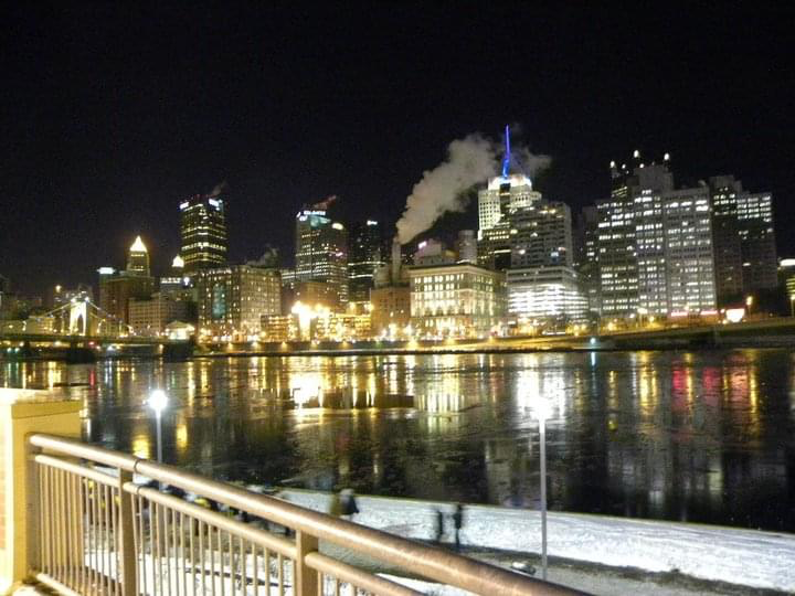
It’s been awhile since I’ve went and I’ve only ever been to 5 Steelers games (4-1 haha) but they were some of the great games. 2005 regular season Pit vs NE (ended with Vinatieri game winner), the 05-06 divisional round vs the Colts at Indy (still craziest game I ever saw in person), 06 regular season vs Chiefs, the 2007 MNF blowout vs Baltimore (one of Ben’s perfect games), and the last one seeing them punch their ticket to the Super Bowl vs the Jets in the 10-11 AFC title game. That was definitely the coldest one being in the single digits most of the game. I did get this picture of the city on the long walk back to the car.
-
2
-
-
Lol all this Miller A/B talk is fun but I’m sitting here wondering why that EC run popped a low on the coast so quickly way in front of the primary wave.
-
 1
1
-
-
8 minutes ago, losetoa6 said:
Nice sharp looking SW getting under us. Nice hit incoming ^
.thumb.png.28b857e25c6091e725db38a18b6439c9.png)
Big western ridge too. Boise, ID is the often referenced point for having the western ridge axis through for C-PA snowstorms and it sure looks like a case of one there. This is the amplification we needed for today’s storm.
-
2
-
-
12z Euro Ensemble >3” probs. Pretty decent, and dead center on PA swath wise.
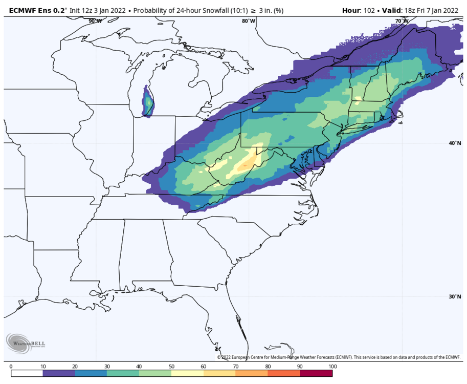
-
1
-
1
-
-
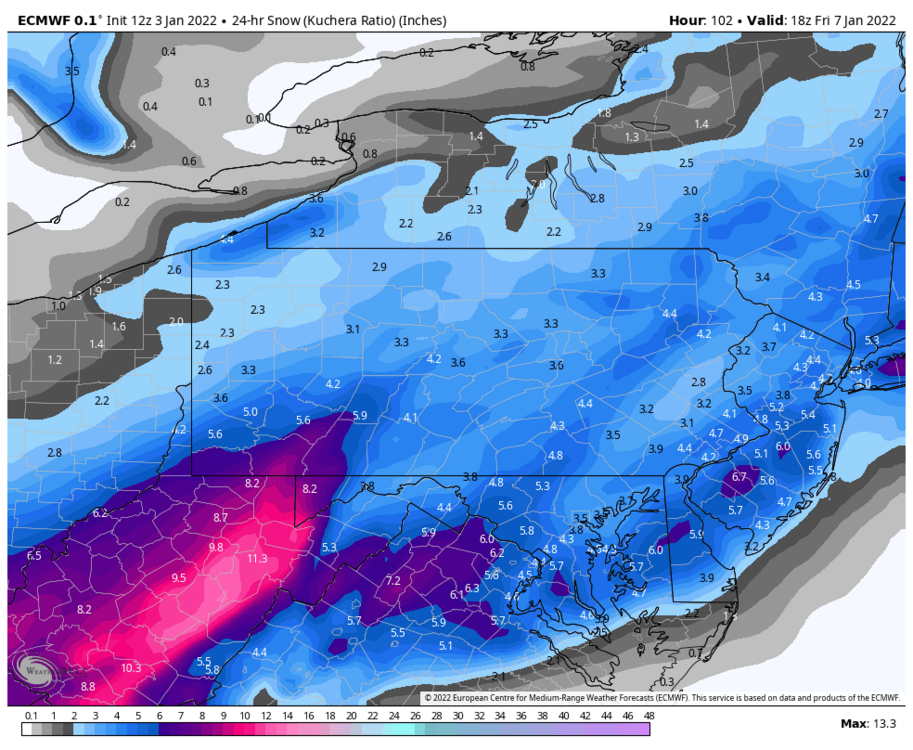
8 minutes ago, Bubbler86 said:
Yes, mine was 10:1 and I saw yours was Kuch. I usually just post the 10:1 maps when something is that far out but in this case I more posted it to say why I think paweather called it a MA special. He was looking at the Surface maps and the darker blues are down there along with the heavier snow on 10:1 terms. I think the important missing piece here is the chance for this to pop as you say. Outside the GFS no go scenario, the Euro scenario is probably worst case if the low does form...it could be better.
Euro didn’t really even have all that much QPF either. The 10:1 DC area vs LSV was more like a 4-6” vs 2-4” event. That’s another thing to keep an eye on is the QPF aspect. Last night’s Euro was one of the biggest QPF runs despite having decent but not heavy events on some of the other runs. I could see this going either way, being a run of the mill quick hitting wave of snow or a more significant widespread event that merits a NESIS ranking. I just don’t buy the GFS non-event, but yea I sure would feel alot better if it got on board soon lol. Still in the mid-range too, which always has these shenanigans. It’s not that far out though really being at D4. We’ll probably be able to have some hot NAM takes this evening.
-
15 minutes ago, Bubbler86 said:
I think looking at a snow map like this one tends to point toward the MA for the heavier snow once East of the Mountains. But I agree with your sentiment that its all fine right now.
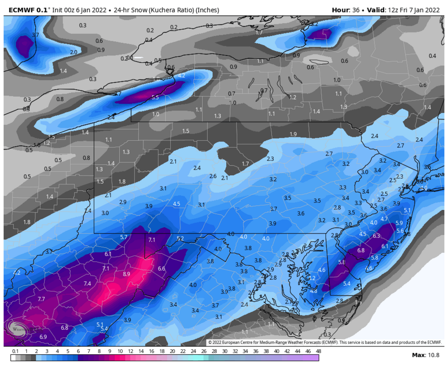
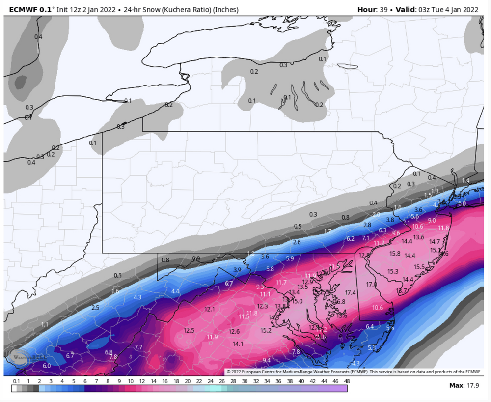
Yea that looks like the 10:1 map which shows a bit heavier QPF down there. I”m using Kuchera for this without really worrying about inflated totals here because if this event occurs in non-GFS fashion it is going to be a cold storm in PA and the column looks great for good ratios for us. Harrisburg has 4.3” on Kuchera with 0.29 QPF (just under 15:1). Just looking roughly at the maps at different levels, 850 temps are -6 to -8ºC (falling) and 700mb temps across PA are a degree or two either side of -15ºC (inside the ideal -10 to -20ºC range for the snow growth layer). So with that I would say a ratio like that in C-PA is completely reasonable. Not to mention climo for C-PA in January for snow ratios is roughly 12-13:1 and this looks like an actual January type snow event.
My personal take is the GFS is having trouble popping the wave with the cold airmass in place and presenting it’s tried and true SE bias of the last x number of years/decades. The set up and shortwave is there at 500mb like everything else and I really don’t see a huge difference other than maybe the GFS is somewhat less robust with the shortwave.. maybe. There’s a much better defined ridge out west for this than for today’s event, so with more amp in the pattern I really think something’s going to pop like what the Euro/Canadian and ensembles (even the GEFS to a degree) have been already been fairly solid on the last couple days. The immediately preceding shortwave over the Lakes that sets this up with the cold and etc probably takes the cutter option away and big question is placement of the best snowfall. Even if it did put the best precip in the 95 corridor again, this one should be more expansive with the shield.
-
2
-
-
Okay, I got maps loading now. C,mon guys.. you make it sound like PA got blanked out. What part of that suggests “Mid-Atlantic special”?
-
2
-
-
1 minute ago, Bubbler86 said:
Where is the euro pbp?
I can’t get anything on Weatherbell to load up model wise. Did the weenies crash it? Lol
-
Boy that’s a brutal cutoff looking at the cameras going up 270 from the beltway. Nothing on the ground in Frederick.
-
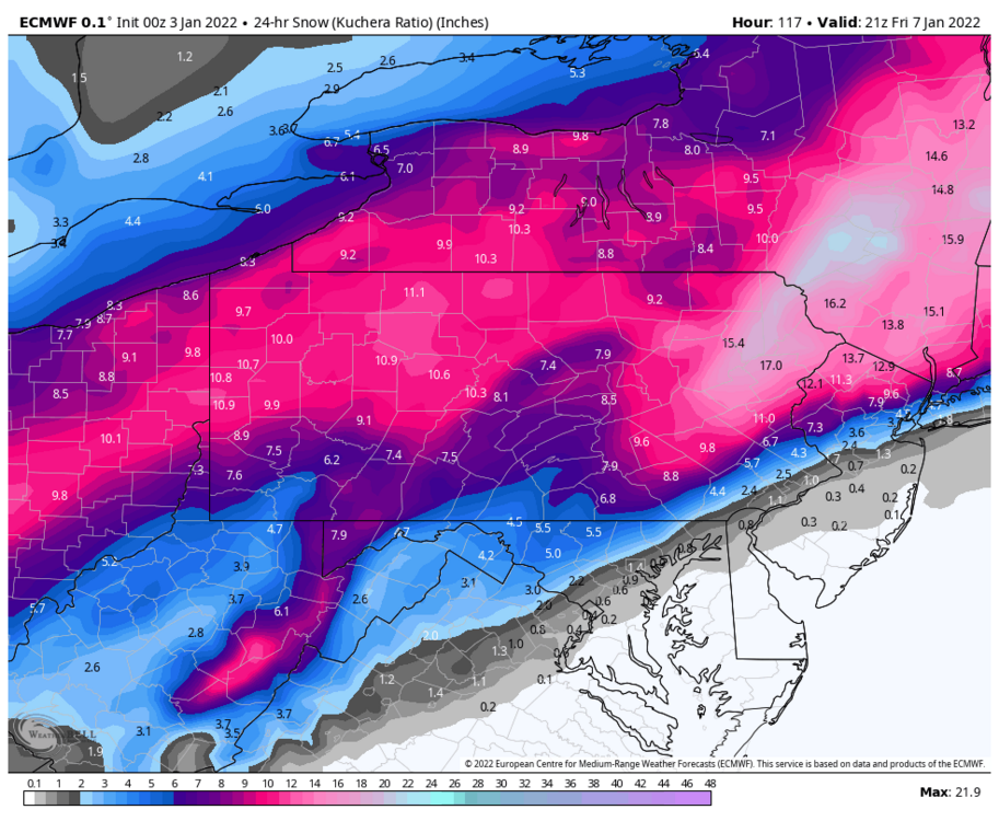
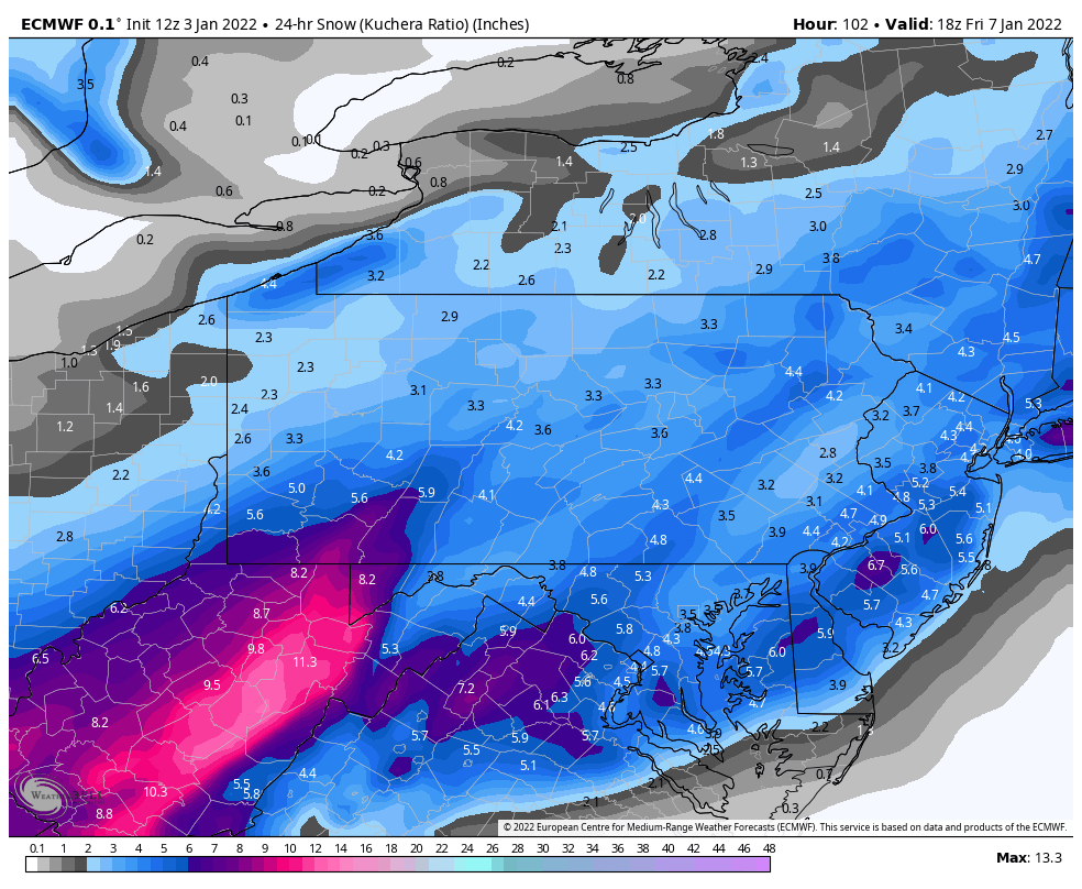
Best run yet of the Euro with the 1/7 storm, really upped the totals. Like I mentioned last night this event is going to be cold on the snowy side. Little mixing at all in PA, looked mostly relegated to far SE PA (Philly). Tennessee Valley-Delmarva transfer. I don’t understand why folks keep asking “where this storm has gone”. Good thing we’re not the Mid-Atlantic forum, someone would say go look for yourself lol.
**Edit to add on 0z Euro ensemble stuff as well. Also, I’m not saying the GFS op is wrong or anything, but again….it’s literally the only thing that doesn’t snow on us with this the last several runs. Even the 0z GEFS has half decent 1”+ probs for PA.

-
1
-
-
It is kinda brutal to watch this evolve. The surface low goes from GA through the interior Carolinas to near VA Beach which is often workable for a good portion of the subforum. It’s a great shortwave but a tight system and there’s not enough amp in the pattern to bring it up the coast some or northern branch interaction digging into it to draw a much broader precip shield.
-
0z NAM starting… gonna be the most important model run of our lives coming haha. I need to nail down how thick the cirrus deck is gonna be here tomorrow.
-
1
-
 2
2
-
-
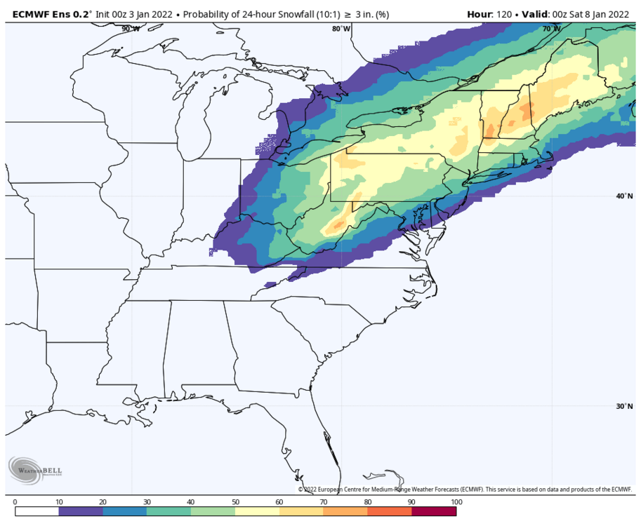
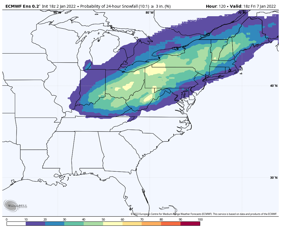
18z Euro ensemble >3” probs for the 1/7 storm. >1+ was more than 50% for pretty much our whole subforum. Still shows a bit of a focus toward the northwestern half of the state.

-
1
-
-
16 minutes ago, Bubbler86 said:
It's good stuff and spot on based on the current models. We have a low sitting off VA Beach and no snow in our hoods....dry air is the answer I would think. In combo with the weak push from the low. Low gets above VA Beach and LSV is in play.
Yea dry air is definitely an inhibitor in this boundary type setup with the cold pressing. Otherwise if the low does in fact track to VA Beach like the GFS especially has suggested, that still is typically an okay track for the southern half of the area (Delmarva is ideal for C-PA). I feel some accumulating snow would find a way just across the M/D if it did that. A lot of the short/near term guidance take the low pressure off at the OBX, which probably would result in accumulating staying below the M/D line.
-
45 minutes ago, Cashtown_Coop said:
Better for us.

Haha that partial post above the post with the snow map… I see two trends in that screen capture lol.
-
1
-
1
-
-
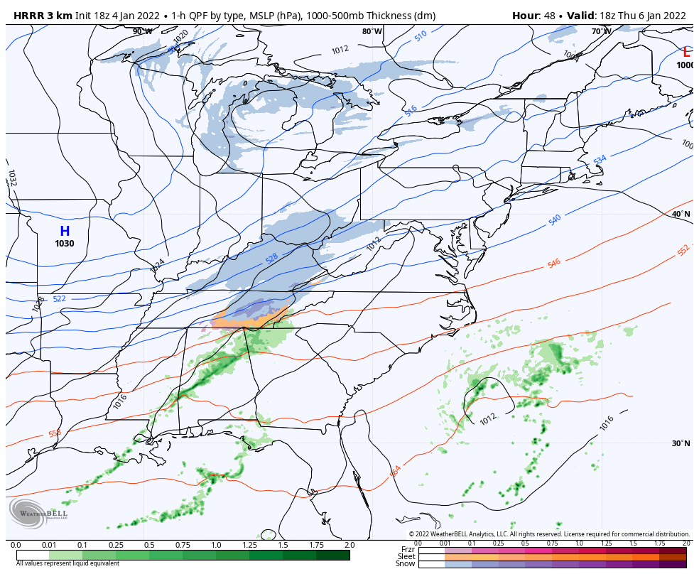
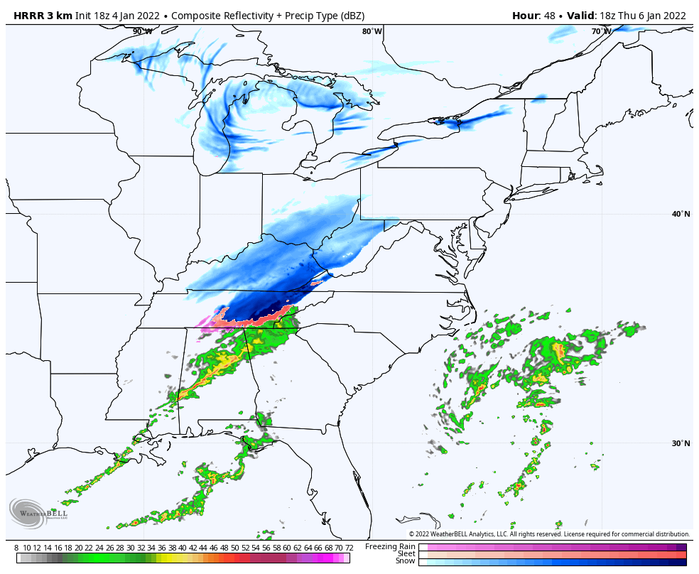
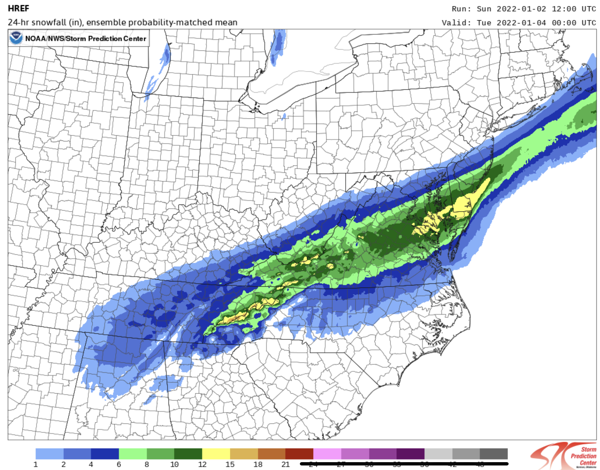
Speaking of short/near term models. Here’s the 12z HREF for posterity. I know CTP utilizes it and pretty sure it was mentioned in the AFD this morning (not being much help at the time).

It seems pretty clear across the model spectrum at this point that 8-12” or so is a pretty good possibility in the axis of heaviest snow. Gonna be important to keep an eye on surface low track. This model put this swath out with a surface low track hitting the coast at the OBX near Hatteras. GFS was a VA Beach track and Euro was pretty close to that too…big difference for the southern tier of our subforum.
-
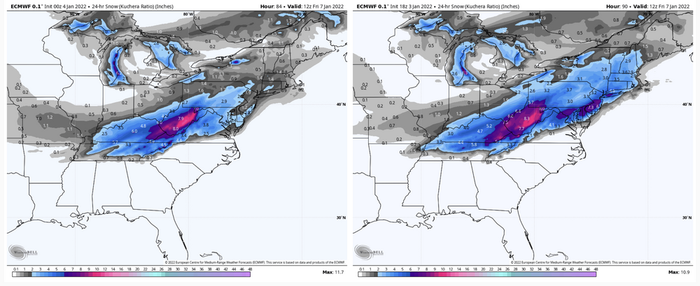
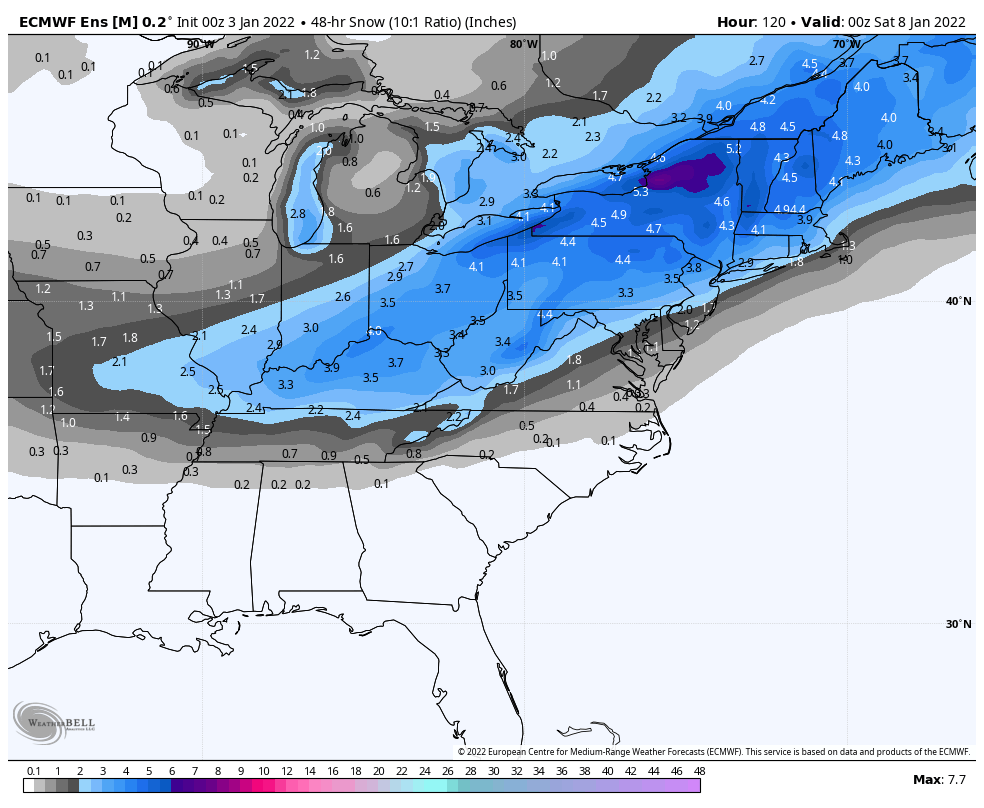
Yea this Euro run is a snow bomb. I know everyone likes to be nit picky and be like cut the snowfall amounts in half and ground temps and blah blah blah but none of that matters the first week of January (or April) with rates like that. DC has like 8 hours of 1”+ an hour and that’s applying 10:1. The column becomes cold during this with -6 to -8ºC all the way down to 925mb. This probably becomes greater than 10:1, hence why I’m presenting the Kuchera while I try not to shed a tear. That would get the 6” line into York and Lancaster.
-
1
-
-
43 minutes ago, Superstorm said:
I mentioned yesterday that our best chance was with the Monday event.
That late week only looked good on Euro. It appears the late week gets caught up in the fast flow.
.That late week system has looked good on everything that goes out that far and their ensembles not named the GFS op the last few runs, though the GEFS has looked like it’s started to support GFS op some with 6 and 12z today lessening it’s snow/QPF mean.
Don’t really think fast flow is the issue, I mean this thing coming up tomorrow is in the same fast flow regime. It looks like GFS may be deeper with the mid-week feature over the Great Lakes that reinforces our cold and possibly sets the table for that event (something I mentioned was probably going to be a key for that late week threat). Also might be somewhat faster with the shortwave that would cause the 1/7 event. So could be why that particular model has been squashing it.
-
1
-


.png.d57a86936d549e68b77cd20487689f35.png)


Central PA - Winter 2021/2022
in Upstate New York/Pennsylvania
Posted
30ºF and cloudy here. It’s got the look and feel outside.