

BlunderStorm
-
Posts
1,235 -
Joined
-
Last visited
Content Type
Profiles
Blogs
Forums
American Weather
Media Demo
Store
Gallery
Everything posted by BlunderStorm
-

Dandridge Dollop 12/24/20 Storm Thread (Winter Wonderland)
BlunderStorm replied to AMZ8990's topic in Tennessee Valley
One more Euro map for the heck of it.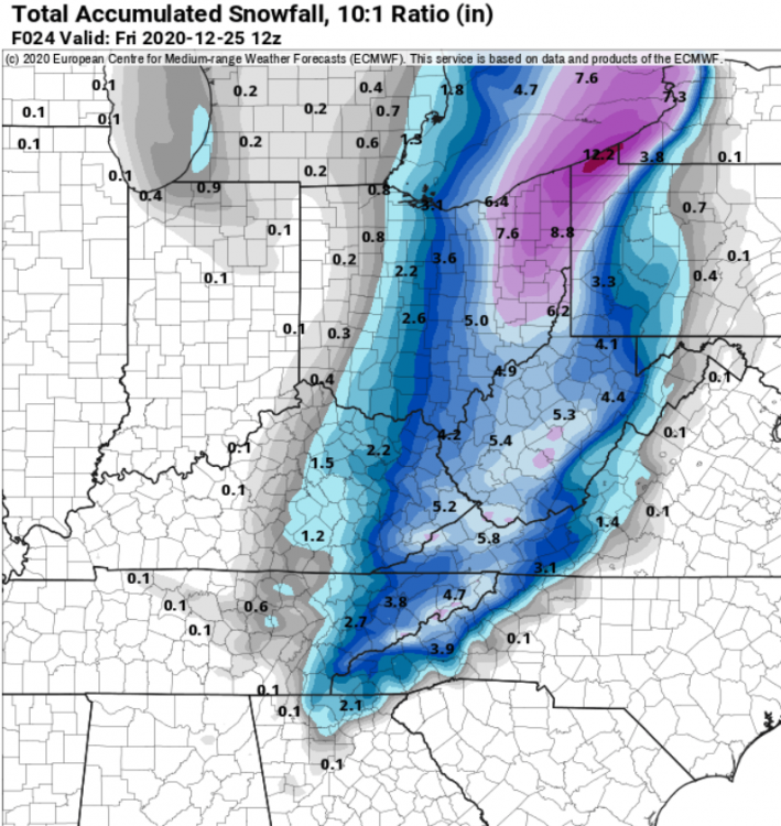
- 847 replies
-
- 1
-

-
- cold temperatures
- snow
- (and 8 more)
-
Dandridge Dollop 12/24/20 Storm Thread (Winter Wonderland)
BlunderStorm replied to AMZ8990's topic in Tennessee Valley
Getting down to the make it or break it part of the event for a lot of areas. Hoping that any moment now the radar will start filling back in towards Crossville and Chatty. -
Dandridge Dollop 12/24/20 Storm Thread (Winter Wonderland)
BlunderStorm replied to AMZ8990's topic in Tennessee Valley
According to the HRRR and RAP Banding redevelops in your area with the development of the leeside low in a couple hours. Aint over yet. Now... if the banding doesn't develop then the entire eastern valley is screwed...- 847 replies
-
- 1
-
-
- cold temperatures
- snow
- (and 8 more)
-
Dandridge Dollop 12/24/20 Storm Thread (Winter Wonderland)
BlunderStorm replied to AMZ8990's topic in Tennessee Valley
You're talkin to the front wearin’, arctic airmass wearin’, road freezin’, thundersnow dealin’, leeside low ridin’, jet stream flyin’ son of a gun!!
- 847 replies
-
- 1
-
-
- cold temperatures
- snow
- (and 8 more)
-
Dandridge Dollop 12/24/20 Storm Thread (Winter Wonderland)
BlunderStorm replied to AMZ8990's topic in Tennessee Valley
Rainfall starting here as of now. Those are some wicked winds coming from the south! Had a gust over 30mph. -
Fall/Winter Banter - Football, Basketball, Snowball?
BlunderStorm replied to John1122's topic in Tennessee Valley
Alternate Version of my reaction to the 12-24-20 0z Euro Kuchera map.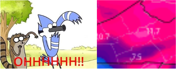
-
Dandridge Dollop 12/24/20 Storm Thread (Winter Wonderland)
BlunderStorm replied to AMZ8990's topic in Tennessee Valley
- 847 replies
-
- 2
-
-
- cold temperatures
- snow
- (and 8 more)
-
Dandridge Dollop 12/24/20 Storm Thread (Winter Wonderland)
BlunderStorm replied to AMZ8990's topic in Tennessee Valley
It's all NOWCAST from here folks! Best of luck to everyone!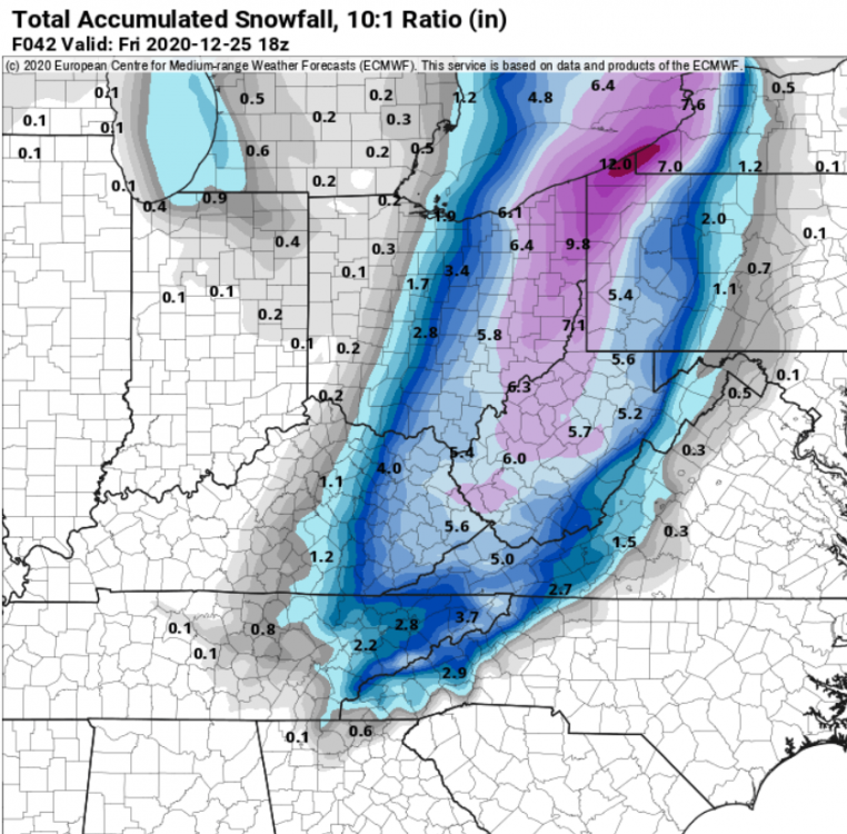
- 847 replies
-
- 2
-
-

-
- cold temperatures
- snow
- (and 8 more)
-
Dandridge Dollop 12/24/20 Storm Thread (Winter Wonderland)
BlunderStorm replied to AMZ8990's topic in Tennessee Valley
Upon initial glance the Euro seems like a marginal improvement. Pretty good imo. The leeside low being slightly deeper than 12z is likely the cause.- 847 replies
-
- 1
-
-
- cold temperatures
- snow
- (and 8 more)
-
Dandridge Dollop 12/24/20 Storm Thread (Winter Wonderland)
BlunderStorm replied to AMZ8990's topic in Tennessee Valley
Yes, it usually begins it's run at 12:50 so we should be wrapped up for 0z at 1:00.- 847 replies
-
- 2
-
-
-
- cold temperatures
- snow
- (and 8 more)
-
Dandridge Dollop 12/24/20 Storm Thread (Winter Wonderland)
BlunderStorm replied to AMZ8990's topic in Tennessee Valley
Yep. Not sure what it's ensemble members are smoking in the deep south though... -
Dandridge Dollop 12/24/20 Storm Thread (Winter Wonderland)
BlunderStorm replied to AMZ8990's topic in Tennessee Valley
- 847 replies
-
- 3
-

-
-
- cold temperatures
- snow
- (and 8 more)
-
Dandridge Dollop 12/24/20 Storm Thread (Winter Wonderland)
BlunderStorm replied to AMZ8990's topic in Tennessee Valley
The GFS is holding the line of significant snowfall and pushing it south and west.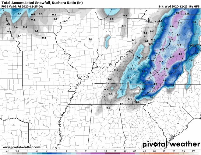
- 847 replies
-
- 2
-
-
- cold temperatures
- snow
- (and 8 more)
-
Dandridge Dollop 12/24/20 Storm Thread (Winter Wonderland)
BlunderStorm replied to AMZ8990's topic in Tennessee Valley
Not to mention the fact that snow aside with such a powerful front passing through you could easily get a flash freeze on bridges causing wrecks.- 847 replies
-
- 3
-
-
- cold temperatures
- snow
- (and 8 more)
-
Dandridge Dollop 12/24/20 Storm Thread (Winter Wonderland)
BlunderStorm replied to AMZ8990's topic in Tennessee Valley
If you squint hard enough and ignore your windows being busted I reckon that counts as snow... West TN cashing in after all!- 847 replies
-
- 2
-
-
-
- cold temperatures
- snow
- (and 8 more)
-
Dandridge Dollop 12/24/20 Storm Thread (Winter Wonderland)
BlunderStorm replied to AMZ8990's topic in Tennessee Valley
I'm rooting more so for a strengthening of the leeside low than it trending west, being probably the east most fella here haha. Better to expand the precip shield behind the front than shift it and delay it imo.- 847 replies
-
- 2
-
-
- cold temperatures
- snow
- (and 8 more)
-
Fall/Winter Banter - Football, Basketball, Snowball?
BlunderStorm replied to John1122's topic in Tennessee Valley
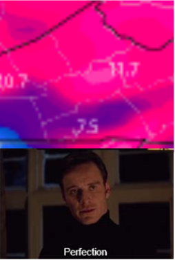
Non-Rushed Dandridge +3KM Version. -
Dandridge Dollop 12/24/20 Storm Thread (Winter Wonderland)
BlunderStorm replied to AMZ8990's topic in Tennessee Valley
NAM Rolling!- 847 replies
-
- 5
-
-
-
- cold temperatures
- snow
- (and 8 more)
-
Dandridge Dollop 12/24/20 Storm Thread (Winter Wonderland)
BlunderStorm replied to AMZ8990's topic in Tennessee Valley
These may be some words I regret but with how the meso models have been trending along with the consistency of the globals I'm gonna roll the dice and say if this storm busts... It's gonna bust the roof off the forecast.- 847 replies
-
- 2
-
-
- cold temperatures
- snow
- (and 8 more)
-
Dandridge Dollop 12/24/20 Storm Thread (Winter Wonderland)
BlunderStorm replied to AMZ8990's topic in Tennessee Valley
You'll probably want to leave in the early to mid morning just to be safe as it will probably rain heavily throughout the whole trip. I would recommend not being out any later than 3 PM. As you will be driving west towards the approaching front heading back. -
Dandridge Dollop 12/24/20 Storm Thread (Winter Wonderland)
BlunderStorm replied to AMZ8990's topic in Tennessee Valley
Any good trends this morning?- 847 replies
-
- 3
-
-
-
- cold temperatures
- snow
- (and 8 more)
-
Dandridge Dollop 12/24/20 Storm Thread (Winter Wonderland)
BlunderStorm replied to AMZ8990's topic in Tennessee Valley
Christmas morning. 06z RGEM vs 06z NAM- 847 replies
-
- 1
-
-
- cold temperatures
- snow
- (and 8 more)
-
Dandridge Dollop 12/24/20 Storm Thread (Winter Wonderland)
BlunderStorm replied to AMZ8990's topic in Tennessee Valley
One thing I noticed on the doomcast HRRR 0z is the division of the front into two waves that hit hours apart as the day progresses. How and why is beyond my understanding but one quick look at the NAM 3km in comparison doesn't show that present. Perhaps something to look out for. (Both screensnips taken at 15z) Check it out yourself on the models. EDIT: Adding to my confusion 6 hours prior and earlier looking at the presentation of the front with 2m temps it appears stronger and more progressive than the NAM 3km.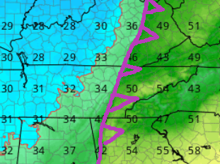
- 847 replies
-
- 3
-
-
- cold temperatures
- snow
- (and 8 more)
-
Dandridge Dollop 12/24/20 Storm Thread (Winter Wonderland)
BlunderStorm replied to AMZ8990's topic in Tennessee Valley
Interesting Update but you would think they would at least relent and lay down some winter weather advisories north and east of TRI.- 847 replies
-
- 1
-
-
- cold temperatures
- snow
- (and 8 more)
-
Dandridge Dollop 12/24/20 Storm Thread (Winter Wonderland)
BlunderStorm replied to AMZ8990's topic in Tennessee Valley
May have a few hours somewhere around the realm of 12-15 MPH sustained intermittently with maybe some gusts in the 20s. That's the vibe I got from the NAM and RGEM at least. Per usual the eastern valley alongside the base of the blue ridge is a little more impressive.- 847 replies
-
- 1
-
-
- cold temperatures
- snow
- (and 8 more)

