BlunderStorm
-
Posts
1,235 -
Joined
-
Last visited
Content Type
Profiles
Blogs
Forums
American Weather
Media Demo
Store
Gallery
Everything posted by BlunderStorm
-
27.6 and within the last 10 minutes precip finally started reaching the ground. Currently 100% Sleet. Curious how long this set-up holds.
-
Hours outta play up yonder but 32/27. Not hourglass shape but I'll take it with a smile. The real battle is above our heads.
-

Fall/Winter Banter - Football, Basketball, Snowball?
BlunderStorm replied to John1122's topic in Tennessee Valley
@BuCoVaWx ???
-
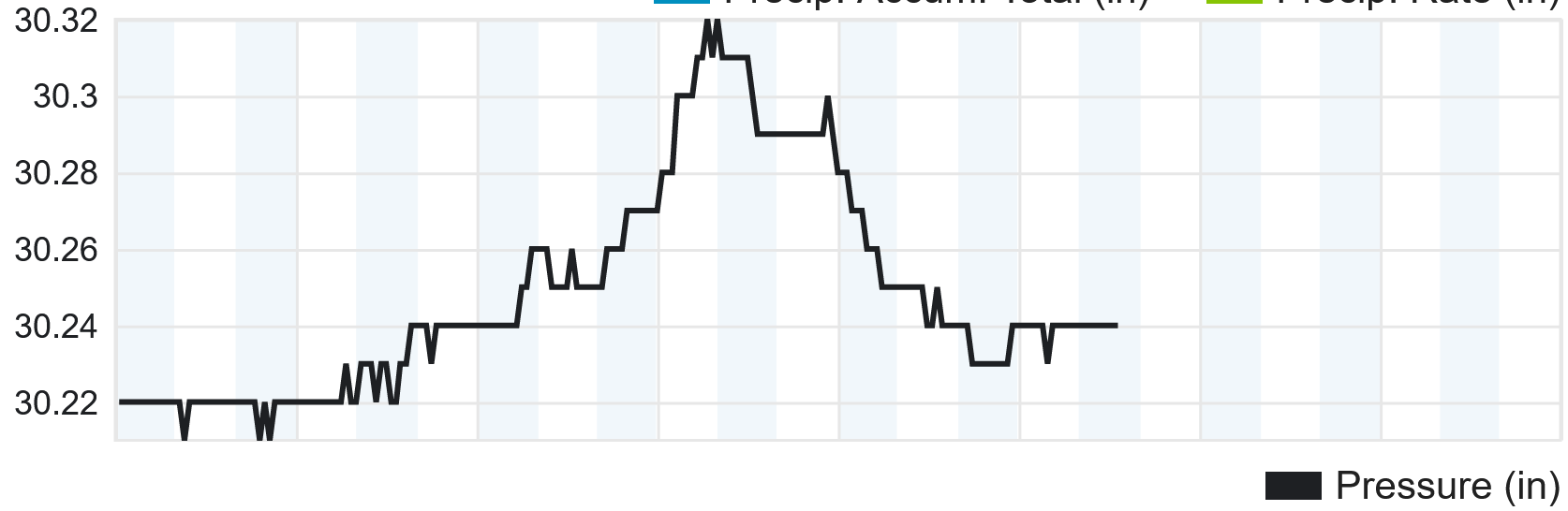
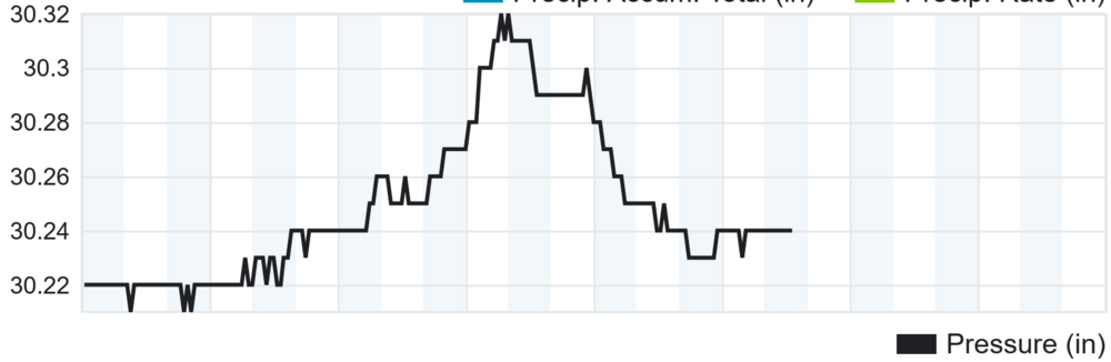
Neat! Just thought I would add my own pressure reading.
-
Anyone know if those super early radar returns south of Crossville are the real deal? On another note looks like the low is about 50 miles due east of Texarkana as of now.
-
SWVA folks might be able to hold on to the upper levels but I doubt it with current guidance especially south of the state line. Our best chance is on the back end with the TROWAL. Even then it's a pyrrhic victory for the far east of the sub forum leaving the plateau and west outta the picture. As it stands nothing in the tri-cities looks right. If I get 2" up my way I'm happy and if I get 4+ I'm ecstatic.
-
The "RDPS" on Pivotal is the RGEM. I didn't know for a long while too. https://www.pivotalweather.com/model.php?m=rdps&p=snku_acc&rh=2022011418&fh=78&r=us_ov&dpdt=&mc=
-
18z NAM 3km at 48 hours... How on Earth you screw up the upper air that much I don't know.

-
The extreme E to W downslope over the spine of the Apps with the latest run of the NAM and to a lesser extent the GFS reminds me of the Jan 2016 Blizzard. Though in the case of that the low transitioned to the coast by Charleston rather than running up to swva then shifting to the Outer banks.
-
Oof. but hey, the mid-state really cashes in.
-
Flurries are reaching the ground yet it has warmed to 37.
-
Just virga as of yet. The sky is a uniform overcast and it is 35.6. The DP is 26.
-
Currently 1.5 inches on the grass but the pavement isn't phased... Yet.
-
No kidding, it was like a light switch from swva to chatty.
-
33 and falling fast! The transition happened during the server outage. Currently raining half dollars. Worth the wait!
-
Now 34.5 and a gift basket of precipitation types.
-
Well, nothing too notable just yet but I did just notice the rain is starting to sound awfully clicky haha
-
Currently 37 in Honaker and the upper Clinch river valley. In a small dryslot now but it's looking like the fireworks are about to start.
-
Wow, just wow. Currently reporting a cool 70 here.
-
Hurricane Ida Forecasting Contest
BlunderStorm replied to WxWatcher007's topic in Tropical Headquarters
Maximum Sustained Wind Overall (mph): 135 Maximum Sustained Wind at Landfall (mph): 130 Pressure at Landfall (mb): 950 Landfall Location: 3 Miles south-west of Cocodrie, Louisiana -
Flakes on the 21st of April. It's the latest I can recall at least. Impressive!
-
T:34 DP:27 Can't wait to get into the action in a few hours.
-
It really is impressive!
-
45 at about 4 PM.
-
T:37 DP:29 up in SWVA. Cooling quickly and partly cloudy.