TPAwx
-
Posts
594 -
Joined
-
Last visited
Content Type
Profiles
Blogs
Forums
American Weather
Media Demo
Store
Gallery
Everything posted by TPAwx
-
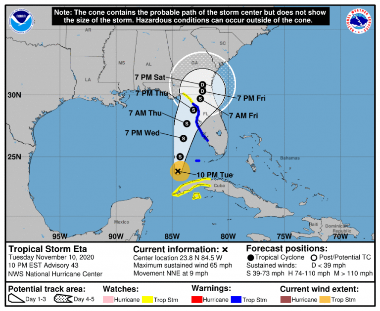
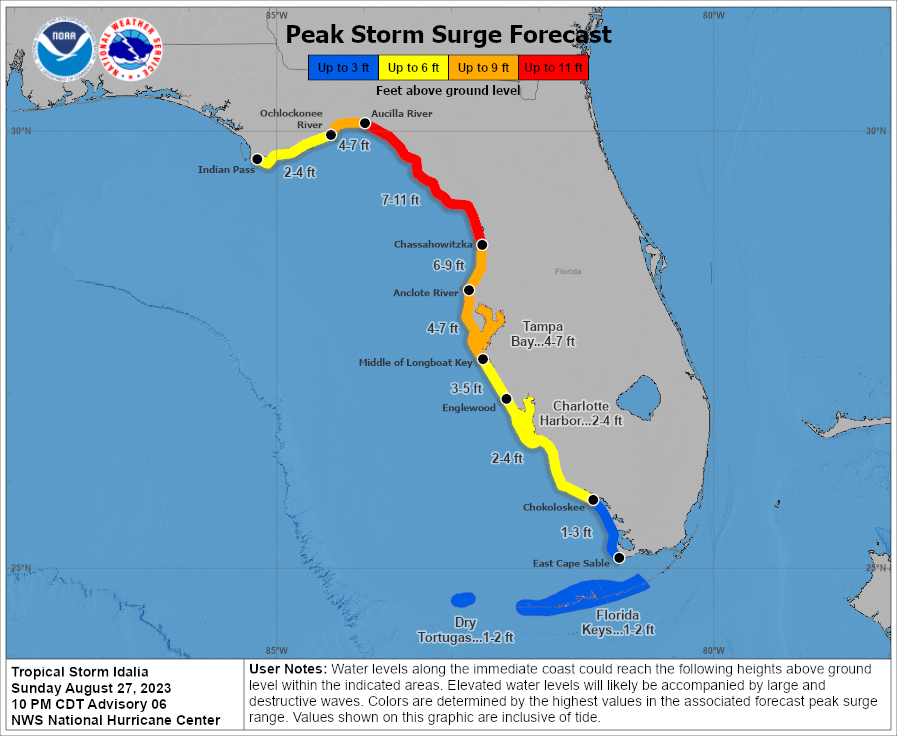
Had 4ft IMFY from TS Eta, on a not dissimilar track maybe a degree to the right of Idi’s current track. Of course Eta had a lot of energy built up. The 4-7 forecast for TB may end up on the lower range of possibilities.
-
Yes Ian evacs were issued for most TB coastal counties on 9/26. Really surprised Pinellas County hasn’t pulled the trigger yet, lots of folks at high risk even with current track. MacDill AFB just went mandatory so would expect Hills and Pinellas to follow soon for Zone A.
-
Euro remains to be seen, even with some westward movement on other guidance no reason for local TB region media mets and municipal officials to let up on messaging and urgency, esp for Zone A and B residents,
-
As 12z suite comes in, thinking about the ~50 n mi average track error at 48h
-
Up from last advisory
-
TS Eta's endgame track across Cedar Key in Nov 2020 gave us 4 ft along Bayshore.
-
Ready to roll out of Zone A but yeah this is going to surprise a lot of folks. We’ll see if the Tampa Bay No Majors in 102 years streak holds.
-
Interesting set up for TB region. Most likely a miss but if steering supports East and it picks up more heat could be problematic.
-
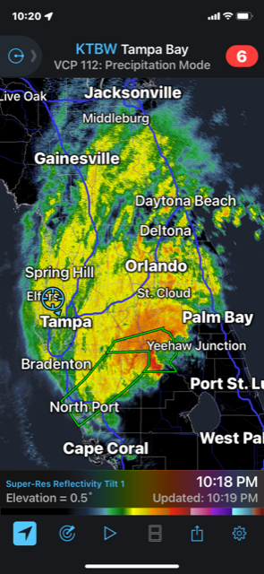
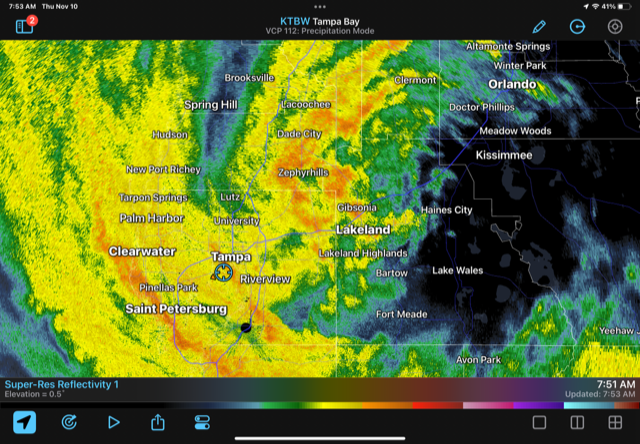
Hefty band passing thru. Max gust so far 53 mph
-
976mb reading on current pass
-
That’s a 5 mb drop. What the reasonable lid on deepening prior to FL landfall?
-
He’s also the resident SME on outer band forecasting and dynamics.
-
That track is just far enough offshore to throw some fetch up the bays. Could be some flooding on top of the full moon tides that catch people off guard here.
-
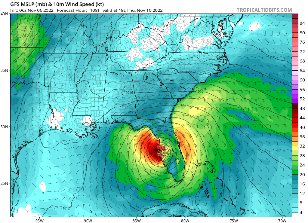
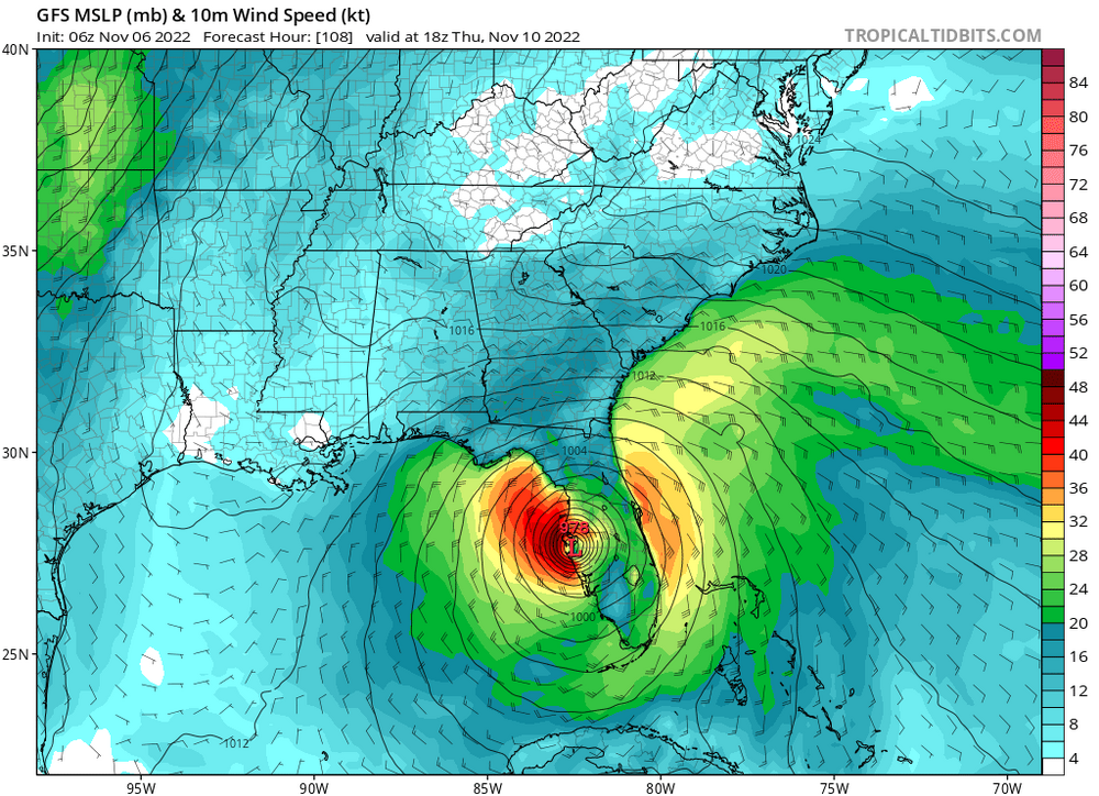
18z GFS a bit SW of 12z as the system heads across the peninsula.
-
992mb @ 7am EST Good to see the updated track staying well north of Ft Myers area and TB
-
GEFS taking this just south of TB on 18z run. Power outages and downed trees/vegetation likely the primary impacts here. Debris cleanup is mostly but not completely done from Ian. Suppose the solutions that take it offshore would bring fetch up the bays and could present some flooding issues for parts of the area.
-
GEFS has the system slightly southwest of the op run thus far.
-
-
Please maintain vigilance as the outer bands approach.
-
Gonna need to turn the TB force field back on, had put it on sleep for the season.
-
Julia | 85 mph 982 mb peak | EPAC Crossover #2
TPAwx replied to Iceresistance's topic in Tropical Headquarters
No threat to the US as this eventually goes into Central America, if it develops. -
Dry and sunny conditions here in the aftermath of Ian. Avg high around 85 for the next week with low humidity.
-
WRT to the next significant TC threat to Tampa Bay metro, sure there is a "cry wolf" variable but most people are able to understand imminent threats to life and property and will act accordingly, especially those most exposed or vulnerable. There is always a slice of the populace, in TB and everywhere, that is skeptical or jaded towards threats from natural forces and will consider it a badge of pride to resist calls to evacuate or even prepare. And there may be more people not in direct peril that reconsider leaving the next time. But there won't be a massive contingent of people refusing to evacuate the next time TB is in the cone a few days out from a significant TC.
-
Watching idiots on the seawall in St Augustine on TWC as waves and spray crash over them. JFC.
-
On the "fringe" of Ian has meant TS+ winds since afternoon and sideways rain for 4 hours and much more to come. No power at home in Tampa, so going to hold off on returning.