

TPAwx
-
Posts
594 -
Joined
-
Last visited
Content Type
Profiles
Blogs
Forums
American Weather
Media Demo
Store
Gallery
Everything posted by TPAwx
-
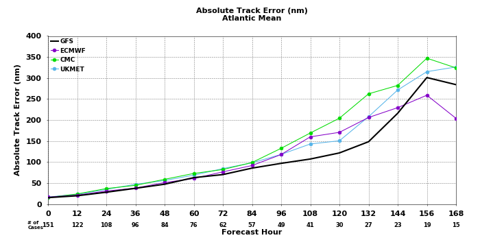
Late in the period, the guidance indicates the storm will begin to recurve toward Florida. As mentioned before, the track models are in general agreement with this scenario, however there is a large amount of cross-track spread at 72 hours and beyond. In fact, the east-west spread in the guidance at 96 hours is about 180 n mi, with the CTCI and ECMWF along the eastern side of the envelope, and the GFS, HWRF, and GFS ensemble mean along the western side. The overall guidance envelope has shifted slightly westward this cycle, and the NHC track has been nudged in that direction and lies just east of the various consensus aids. Given the spread in the guidance, and the still shifting dynamical models, additional adjustments to the track forecast may be needed in subsequent advisories. Users are reminded that the long-term average NHC 4- and 5-day track errors are around 150 and 200 n mi, respectively.
-
Didn’t realize Tampa city limits are 100 miles north of town
-
Along with an acknowledgement of increased track uncertainty late in the forecast period.
-
That GFS solution lays an atypically long duration S to SW fetch on TB and the coast. Lots of water to deal with even tho it stays offshore.
-
Always wise to get a jump on prep. I’ve seen enough from the 12z GFS to book a hotel in GA for next week as a contingency. Will most likely not be needed.
-
37 events over 175 years, 11 in the last 50 years. Reckon we all have subjective views on the meaning of frequency and rarity.
-
Interesting for sure. We’ve beaten the Tampa thing to death, but it’s pretty rare for a major to landfall anywhere in Florida.
-
It’s not the worst case scenario based on that track. Yes it would be a significant impact and highly disruptive. Trajectory needs to be mid to north Pinellas Country to maximize surge potential. And correct, Tampa will not be hit directly by a major hurricane next week.
-
lol
-
Yeah it’s not going to take 30 hours to cross the peninsula.
-
Unfortunately for those that marinate in such scenarios, the odds are near zero that it happens, ever. Of course a Cat 1 on the Hurricane Phoenix trajectory would cause billions in damage here, so a big hit doesn’t need to be a high end storm.
-
Wanting a TC or post tropical system with massive accumulated energy to visit YBY is a bit like the dog catching the car, FAFO, etc.
-
-
More like 100 miles N around Cedar Key but it’s just one of many TBD op run track simulations
-
Yeah nothing says Fall like a 101 heat index
-
TC development patterns and steering currents are unfavorable for frequent local impacts, this goes back at least 175 years in available records. Eroding TS Eta caused more impact IMBY and for many here than Irma, which set off panic for a week out. We really don’t want anything of significance to landfall near or a bit N of TB.
-
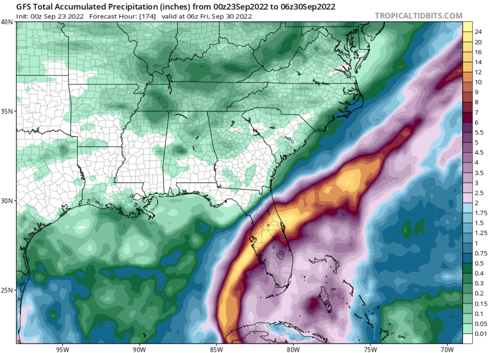
6z GFS says Farewell and Adieu to Tampa/St Pete area. Not far off from worst case track and surge scenario, albeit less intense. We’ll see lots of these super bad simulations jumping around the map over the coming days.
-
Thoughts and prayers as you contend with ongoing moderate showers and breezy conditions. Stay vigilant.
-
Horrific. Very detailed and engaging first person account of the Amazon warehouse on msnbc a few minutes ago. Should be on video later.
-
There’s a level of enthusiasm for weather and meteorology, and hurricane tracking, that’s understandable and a lifelong passion for many. And then there’s sociopathy. Helpful to understand the difference, and not claim exemption due to “muh weather forum.”
-
That’s fair, tho Memphis and Nashville have great food and music scenes.
-
You really don’t want that HMON solution up yonder.
-
it’s actually pretty funny that the admins allow a red tagger parody account.
-
Yeah science and data based forecasting by top expert professionals is totally overrated.


