TPAwx
-
Posts
594 -
Joined
-
Last visited
Content Type
Profiles
Blogs
Forums
American Weather
Media Demo
Store
Gallery
Everything posted by TPAwx
-
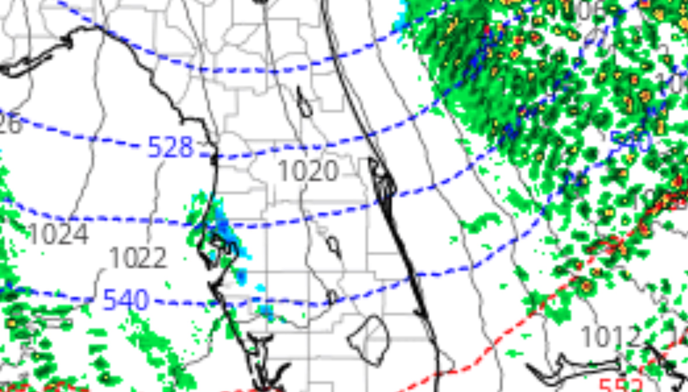
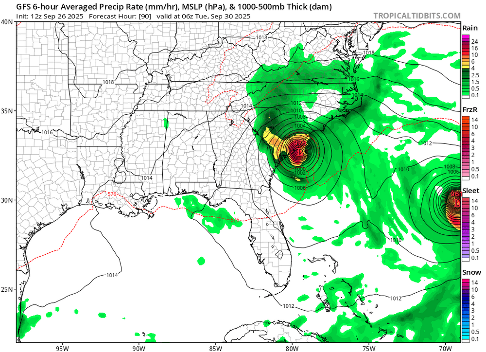
Expecting significant temp departures and strong onshore flow as main impacts. Extract from TB discussion highlights precip dynamics Last dusting of snow in TB was 1977. As has been mentioned with previous discussions, there will be a number of hazards associated with this sequence of events that run from a low probability of occurrence to a very high probability of occurrence. Starting with the highest likelihood of occurrence: - Extremely hazardous marine conditions will develop over the weekend and a Gale Watch is in effect for Saturday through Sunday morning, and this will likely be upgraded to a warning later today. Also, a few gusts to storm force will be possible. - The arctic air will also usher in the coldest temperatures of the year. An Extreme Cold Watch is in effect for all west central and southwest Florida with the exception of Pinellas, coastal Hillsborough, Coastal Manatee, Sarasota, Coastal Charlotte, and Lee counties. The criteria for an Extreme Cold Watch is for the potential of wind chill values of 10 degrees or less for Levy, Citrus, Sumter, and Hernando counties...and wind chill values of 20 degrees or less for Pasco, Pinellas, Hillsborough, Polk, Manatee, Sarasota, Manatee, Hardee, DeSoto, Highlands, Charlotte, and Lee counties. A Freeze Watch is also in effect for much of the region Saturday night into Sunday morning and Freeze Warnings will likely be needed for much of the forecast area both Saturday night and Sunday night. A hard freeze will be possible across the nature coast Saturday night and Sunday night with lows in the lower to mid 20s each night. Temperatures across the interior are expected to be in the mid to upper 20s both nights...with lower to mid 30s near the coast and across southwest Florida. Gusty northwest winds will create wind chills Saturday night in the single digits to teens across the nature coast. Wind chills are expected to be in the teens across the interior, and generally in the 20s elsewhere. The wind is expected to taper off Sunday night, with wind chills generally about 3 to 5 degrees below the ambient temperature. - Temperatures will run about 20 to 25 degrees below climatic normals Saturday night through Sunday night. Could see some record low temperatures set Saturday night/Sunday morning across the region...some low max temperature records set on Sunday...and some record low temperatures again Sunday night/Monday morning. - Along area beaches, very strong rip currents are expected to develop Saturday through Sunday. There is also a low to moderate probability of high surf. - The strong northwest winds may also create water levels along the coast from Citrus to northern Pinellas county to run 1 to 2 feet above astronomical normal tide levels Saturday and Saturday night. This is also in the low to moderate probability of occurrence. - The strong winds and CAA over the coastal waters will create a very unstable turbulent boundary layer. Residual low level moisture will likely allow an area of cold air strato-cu to develop over the eastern Gulf on Saturday and Saturday night. With these extreme conditions in place, it would be expected to see a few light showers or sprinkles to develop over the coastal waters...Gulf effect type light showers. The backside or northern extent of the cloud shield could see temperatures dropping into the mid to upper 30s Saturday evening and after midnight...which could allow the light rain showers to become light mixed snow/rain showers or light snow showers/flurries. Trajectories would indicate that the clouds may advect locally onshore...with the best chance of seeing frozen precipitation from Citrus to Pinellas/Hillsborough counties. This is a low probability event...but not out of the realm of possibility. It will be a race between whether temperatures can drop into the 30s before the drier air wins out and pushes any light shower activity south of the area. It`s common in scenarios like this that drizzle or very light rain gets reported as snow...when in fact surface temperatures don`t support that possibility.
- 1 reply
-
- 4
-

-
The “I bring the mojo” Jan 30-Feb 1 potential winter storm
TPAwx replied to lilj4425's topic in Southeastern States
Would be good for the sheer novelty and to isolate from the main event in the Carolinas. -
The “I bring the mojo” Jan 30-Feb 1 potential winter storm
TPAwx replied to lilj4425's topic in Southeastern States
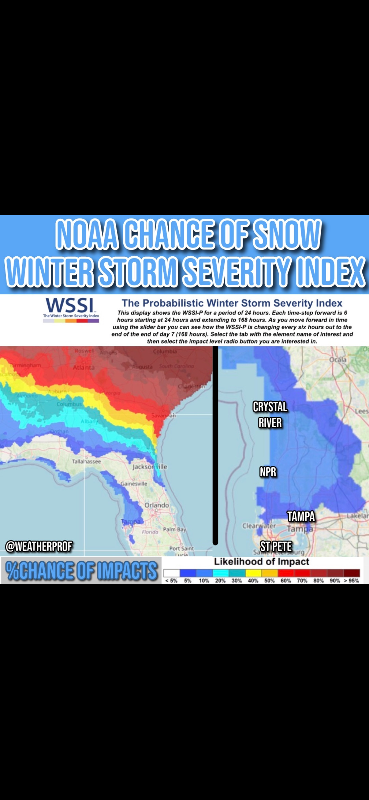
Very rare chance for Tampa Bay area to see flakes in the air overnight Saturday. Maybe even a dusting in some spots further up the Nature Coast. NAM 3K 2AM Sun lol.
-
The “I bring the mojo” Jan 30-Feb 1 potential winter storm
TPAwx replied to lilj4425's topic in Southeastern States
Unlikely but it’s a feasible set up. Last snowfall here was 1977.
-
Major Hurricane Melissa - 892mb - 185mph Jamaica landfall
TPAwx replied to GaWx's topic in Tropical Headquarters
9:00 AM EDT Tue Oct 28 Location: 17.6°N 78.1°W Moving: NNE at 7 mph Min pressure: 896 mb Max sustained: 180 mph -
Major Hurricane Melissa - 892mb - 185mph Jamaica landfall
TPAwx replied to GaWx's topic in Tropical Headquarters
2:00 PM EDT Mon Oct 27 Location: 16.5°N 78.3°W Moving: WNW at 3 mph Min pressure: 906 mb Max sustained: 175 mph -
Early AM Tuesday
-
0z GFS Op goes up the GOM from WC off TB 9/14, so la la land. GEFS appear to showing that dev thru mid run.
-
And 113 for peak heat index. Summers are getting unreasonable here.
-
40-year NOVA alum watching from afar. Great pics and looks like a nice winter event for most of you! All those winters up there trained me to never count on the high-end scenarios from any model run. 4+ is pretty good, even if a bummer after signals for much higher totals.
-
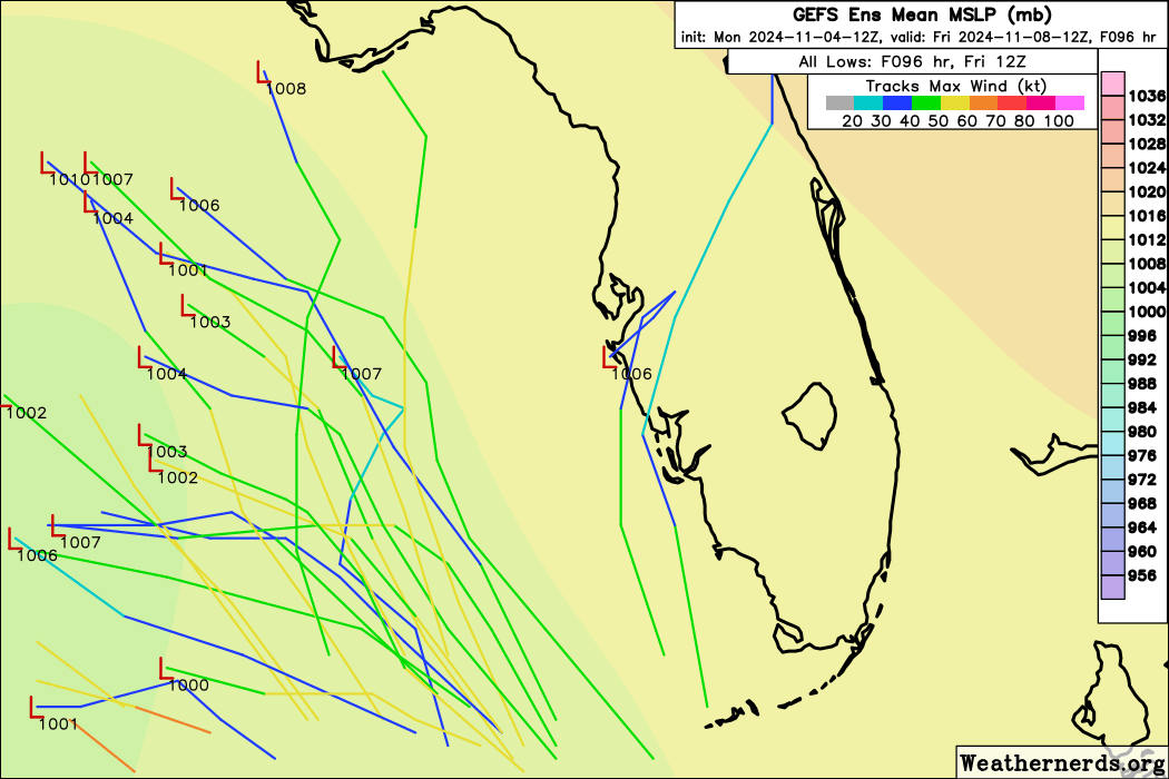
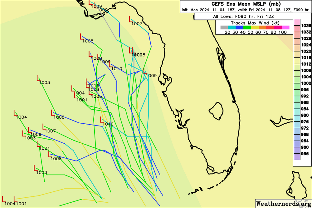
GEFS has two main clusters. Largest into Central America, other to NE tip of Yucatán or just East and across Gulf to far SW FL.
-
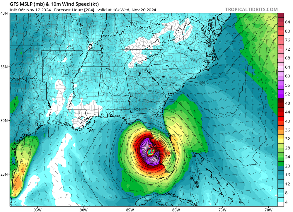
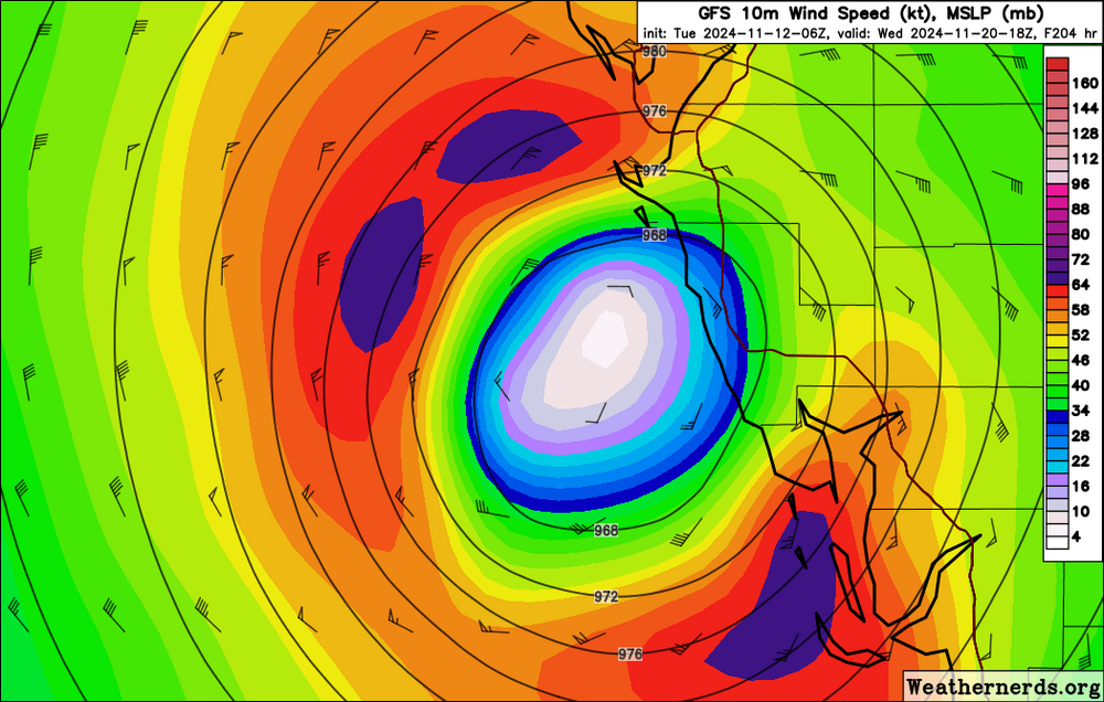
Well this GFS op goes to 922 before heading to the NE Yucatán. Assume this ends up between Ft Myers and Marco later in the run.
-
GEFS has a cluster moving over the Yucatán into the Gulf to the FL central West Coast, and a second moving over Western Cuba into South FL.
-
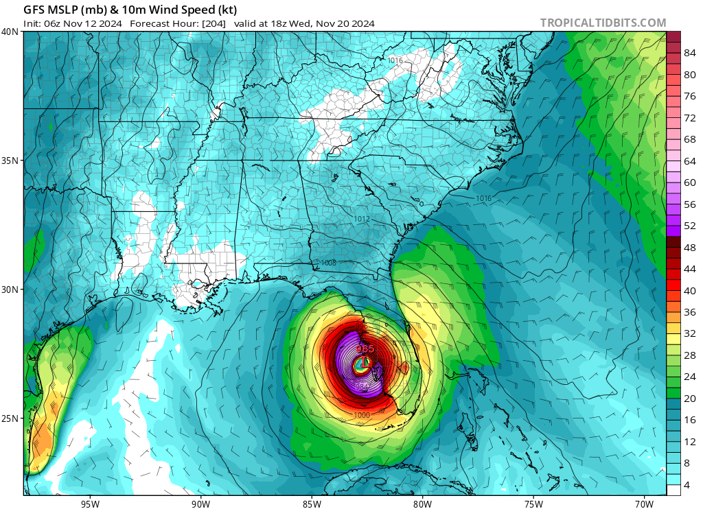
That’s fair, especially so if it was just one run in isolation. GFS is getting persistent with signaling a strong TC into the Gulf and landfalling on FL West Coast next week. 18z has a 2 or 3 landfalling just north of Crystal River next Wednesday.
-
Nothing to see here. Just a major landfalling on FL West Coast a week before Thanksgiving.
-
A few EPS members shift east but remainder are into central Gulf.
-
Just one run but some eastward clustering.

-
A few GEFS members go over west/central Cuba then cut across SE Florida and out to sea.
-
12z GFS op has a major in the Eastern Gulf at 300+. Obviously too far out at this point.
-
TPA peak wind gust was 85 with 12” total rainfall. 72% power outage rate in Hillsborough County as of last update. Daybreak will reveal scenes of trees down everywhere and damage to structures. Tons of standing water, we get that here from PM summer thunderstorms, let alone a foot of rain. Significant impact but manageable. Anything close to peak surge would have been an entirely different story this morning. We’ll see versions of that devastation down the coast. No idea of personal impacts. Lost power and feeds to the security cameras at 9 last night. Not expecting any structural flooding from the rain, but may have tree damage to the house.
-
-
+ Structual damage from downed trees and extended power outages.
-
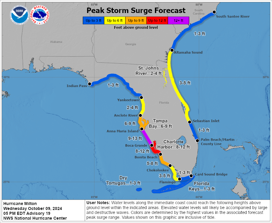
Unless Milton tugs due north in the next few hours the worst case surge scenario is off the table for Tampa. From 10-15 to 9-12 and now 6-9. High winds from the northern eyewall will do a number on the oaks and tree canopy. Lots of roofs and structural damage. Flash flooding from the heavy rainfall. Extended power outages.
-
Primary impacts for Tampa will likely be wind driven damage and flooding from excessive rainfall. Trees down on houses, extended power outages. Surge expectations are trending downward.
-
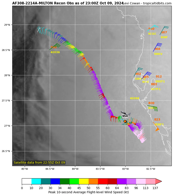
3 of 4 hurricane model landfalls clustered at Anna Maria Island/Holmes Beach. HAFS-A a bit south near Sarasota.