TPAwx
-
Posts
594 -
Joined
-
Last visited
Content Type
Profiles
Blogs
Forums
American Weather
Media Demo
Store
Gallery
Everything posted by TPAwx
-
Then don’t look at the HAFS-B. Gassed up the cars in South Tampa. Target and Publix lots were pretty light, assume panic sets in tomorrow unless a significant south shift.
-
GFS landfall appears to be between Cedar Key and Crystal River 960s Not as extreme for TB but still a high end surge event.
-
GFS looks a touch slower or maybe just a bit south thru 60h vs 12z
-
Wow certainly not. Hyperbole is overused these days but this setup continues to progress towards worst case for TB/Pinellas and Hillsborough Counties most specifically.
-
The pre could certainly complicate evacuation scenarios.
-
GFS is a devastating setup for TB. Shifts in track and intensity obviously crucial for whatever areas are S and E of landfall.
-
Knocked out the initial Publix run for water. As we are in Zone A/closest to water always proactive with planning, but most of our go-to inland hotel options are sold out already, probably due to folks displaced by Helene. Managed to book one night in different cities Tues and Wed.
-
-
Local mets doing a good job after the 6z runs in highlighting the potential. The supply situation is dicey in many parts of the areas. Water, toilet paper, cleaning supplies , etc all in short stock.
-
It's all across the TB area. Debris removal has been in progress, but the scale of the job is enormous.
-
That sucks, best of luck. We have multiple friends and neighbors that lost primary or second homes, and many others dealing with damage. Milton would literally defeat a lot of people here. Still developing so a range of outcomes are possible.
-
For this cycle all landfall north of TB. Big time surge set up.
-
GEFS tracks clustered between Sarasota to Crystal River.
-
Landfall appears closer to Homosassa/Crystal River. Still a significant problem for TB.
-
meant to drop this here
-
That run would be bad news Wild.
-
GFS coming in hot.
-
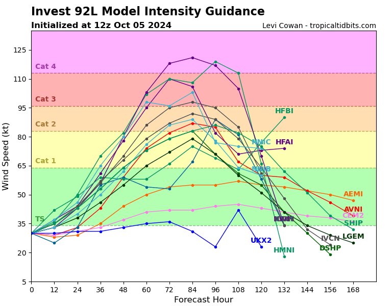
Some of the EPS members that track and landfall just north of TB suggest cat 2 or maybe cat 3. That trajectory and strength are concerning for the Bay area but still just scenarios at this point.
-
Verbatim the Euro op landfalls south of TB around Sarasota/Siesta Key midday Wednesday.
-
True, tho we still have the wide average track error at this stage. Point taken that the signal is there and the set up could support development. I'm certainly watching like a hawk. GEFS still running, most members pointed between St Pete and Ft Myers at this stage.
-
Well the 12z GFS op is grabbing my attention, at least until the next model run that loses the TC
-
Rough estimate of 25k homes/properties in the immediate TB with some level of damage or impact, ranging from minor to total loss. So yes people are preoccupied, and that’s just this region. Local outlets have been highlighting the tropical watch area and potential rain event, but 5-10 inches of rain over 7 days doesn’t raise an alarm for most people here. The op and ensembles are still too volatile to capture and dial in attention.
-
The final toll will be dreadfully high. 10 known fatalities in the TB region. 8 in Pinellas County, 2 in Hillsborough/Tampa.
-
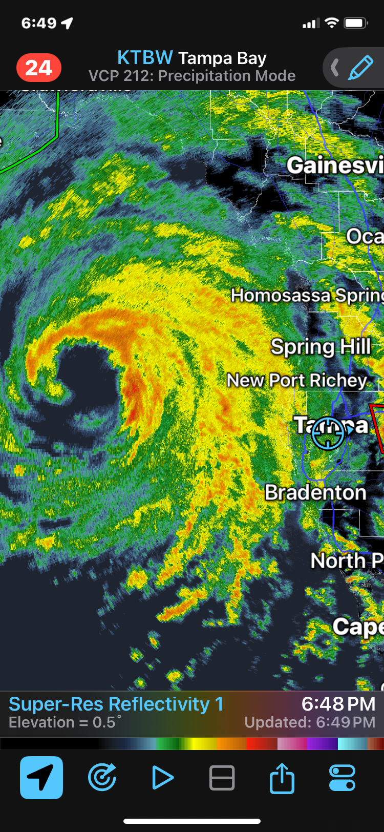
The flooding across a huge swath of Florida will be a big part of the story. We understood the surge forecast but it’s unprecedented in many areas. Just in from a survey of the hood in South Tampa, we flood easy but it was jaw dropping. And two hours until high tide with continued onshore flow. Heading out again after a band passes thru.
-
Some of the stiffest gusts of the day. Now the surge will really start to crank in and build towards early AM high tide. Should hit top end of the 5-8 forecast.