SENC
-
Posts
892 -
Joined
-
Last visited
Content Type
Profiles
Blogs
Forums
American Weather
Media Demo
Store
Gallery
Everything posted by SENC
-
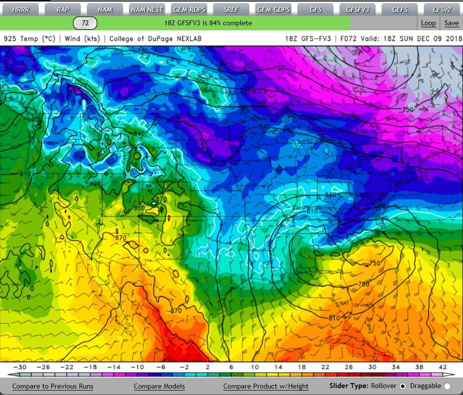
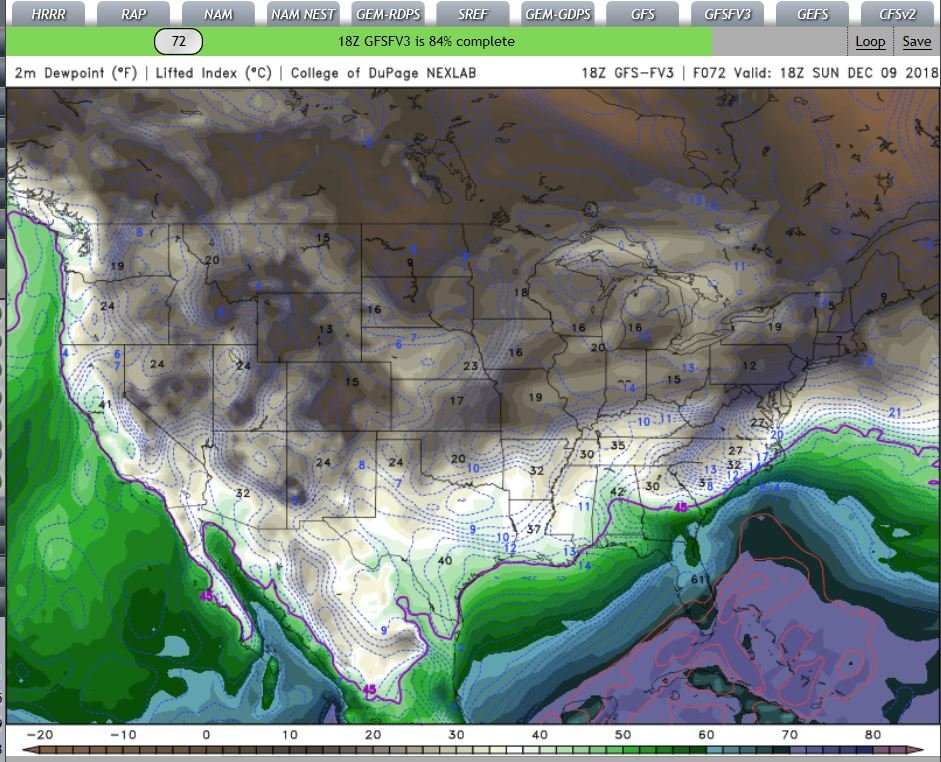
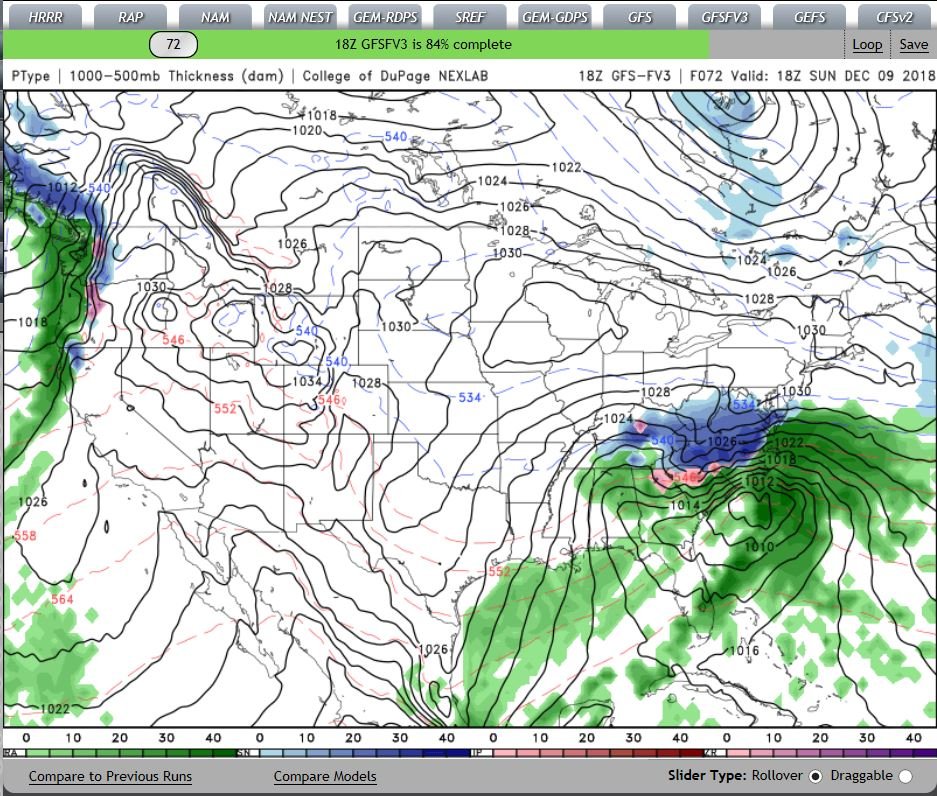
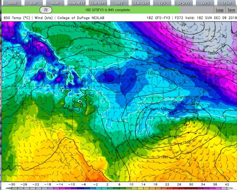
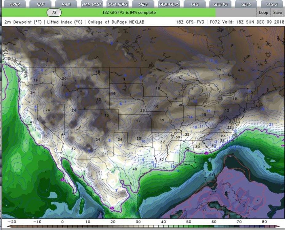
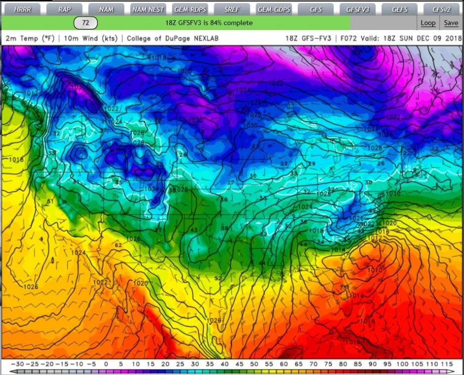
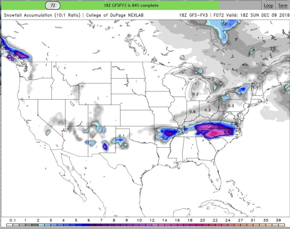
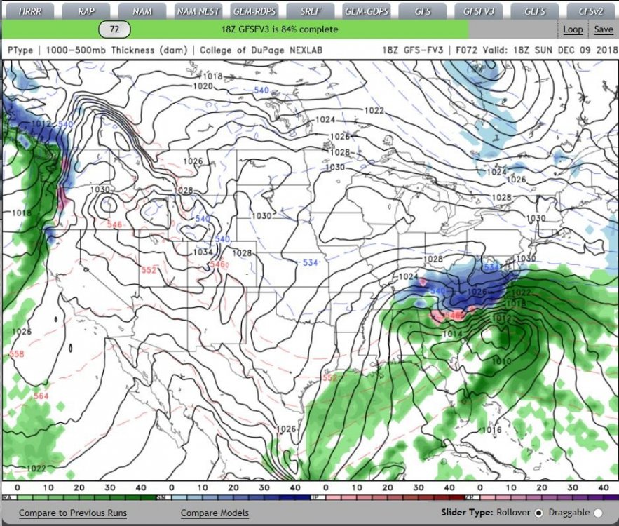
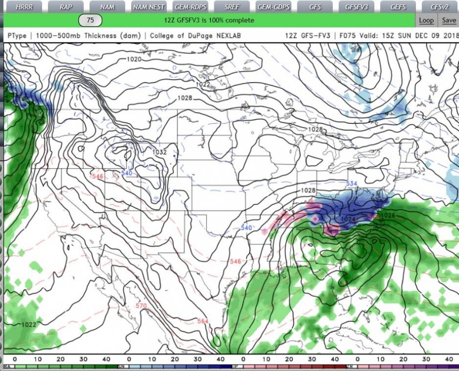
I HOPE the above Images give folks some Hope, I assume this is the "onset" of the Storm.. 72 Hours out.. I tried to get All the Relevant Images..
-
next 3
-
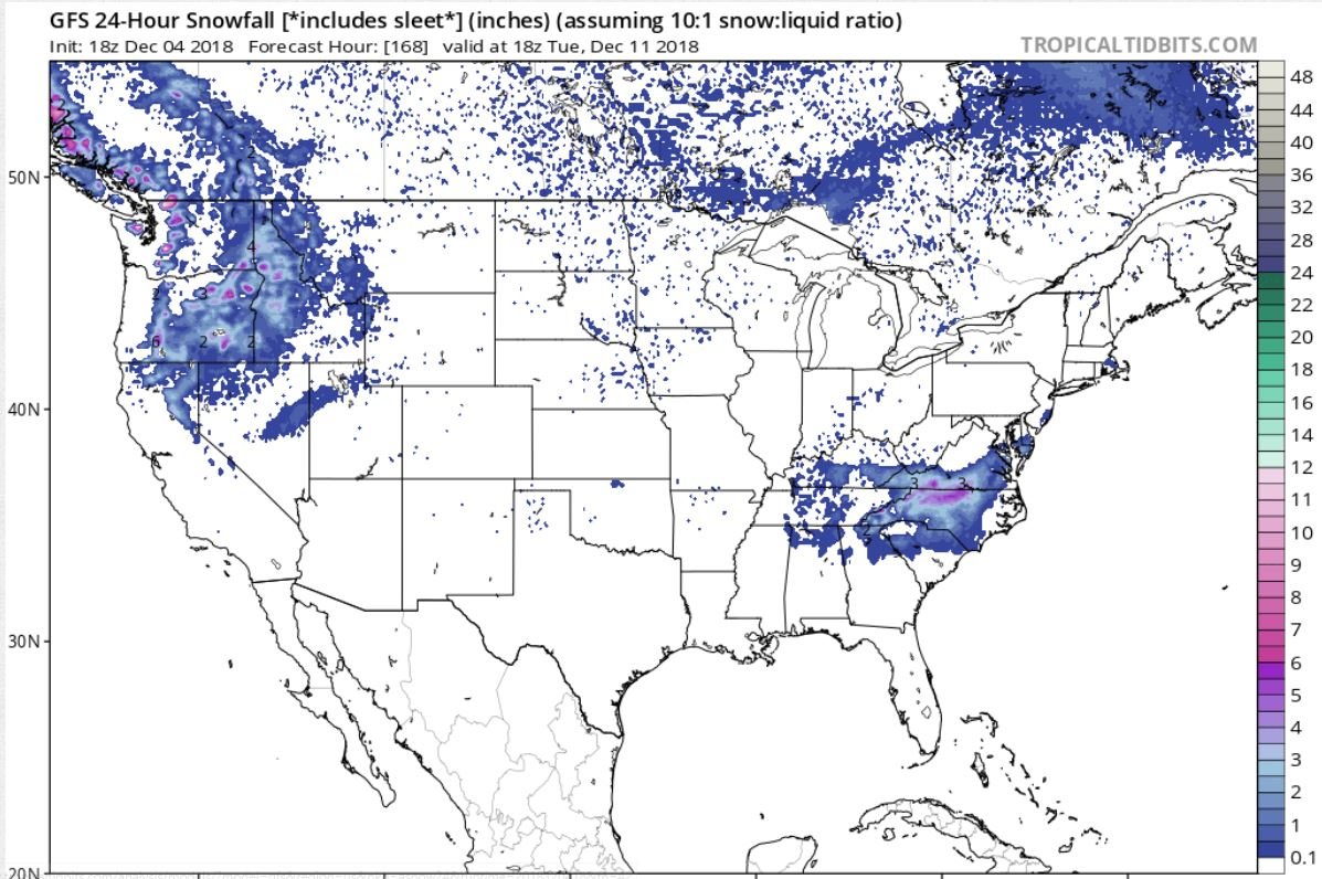
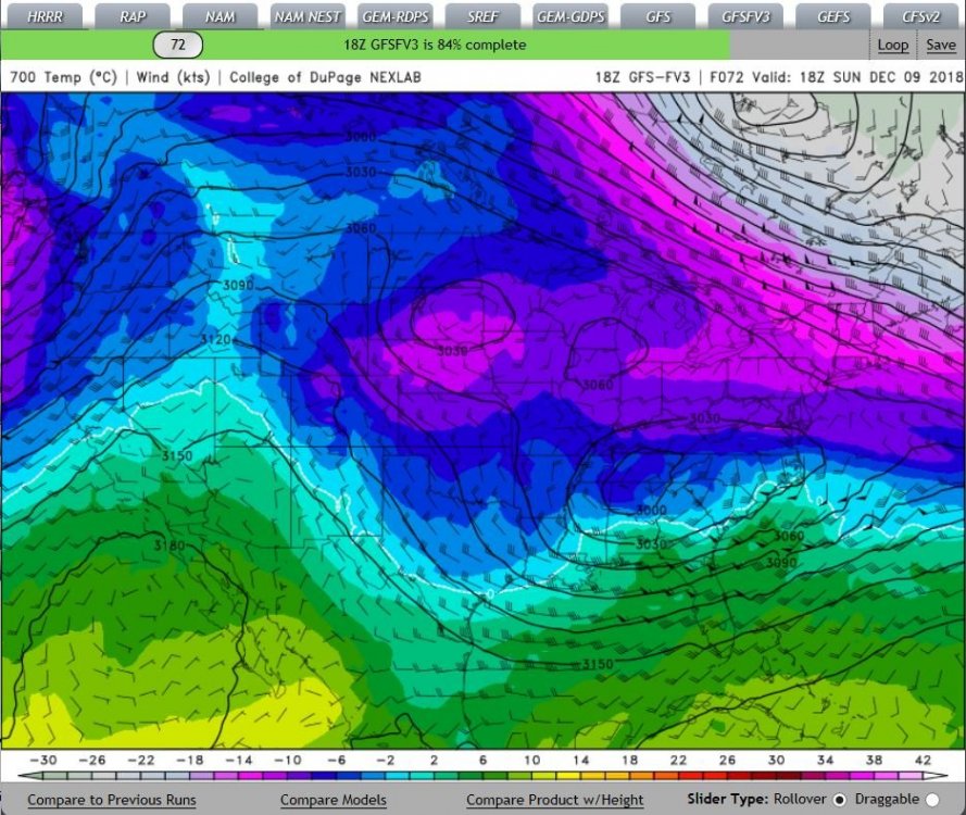
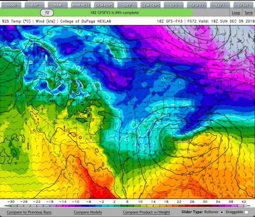
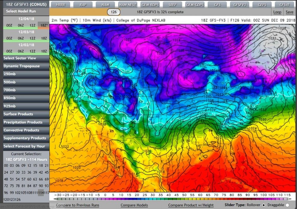
This will be a 2-part post Image heavy.. I hope thishelps.. 18Z GFSFV# run(ing).. Says 84% complete) I took it out to Hour 72 in all images..

-
So are we "Mostly" in agreement yet?.. Some need Sleds & Ski's .. While others, (South & East of the I-85) Will need either Life jackets, or a Ice-breaker, type of Noah's Ark for the upcoming event? @Orangeburgwx & I will need Life-Jackets AND A ARK.. Let me know If I need to pick you up "buddy", @Orangeburgwx, I'm prepared to go "goose" hunting.. I'll swing by & pick ya up in this..
-
I forgot the /SARC tag..
-
I read the Whole Blog.. Nice thinking Outside the Box, considering the "upstream" ramifactions on Our Local Weather.. Thoughts on this @griteater??
-
you need a Oculus Rift!
-
Maybe We can get a "BOMB-O-Genies" (Rubs Magic Lamp) yet still.. Me and @Orangeburgwx are "hopeful"..
-
Well this time around there will be Lotsa QPF to break ya'lls fall!

-
Thanks for this @Wow, shows quite a bit of "variables" in these Forecast(s),, Quite a complex System.. Lotsa "players" on the Field ATM.. Realistically, anything is still on the Table at "Gametime" ,, Will this be a "Run out the Clock" to the Last Moment in the "End-Zone"?? 4th & Goal w/ .01 on the clock? While down by 2 points? Until We see the LP position sets-up/transitions in the Gulf, or around New Orleans, into Florida, Anything is still quite possible? Including "Bomb-O-Genesis" Off the SE Coast A-la Jan 3~4 2018? (Yes; fantasy) I know but still,, it could somewhat be on the Table if the LP gets further south? Say off Jacksonville to Daytona Beach? Asking for a "friend"..
-
Looks "somewhat" better for Me & @orangeburgwx , on the backside, We "might" see "something"..
-
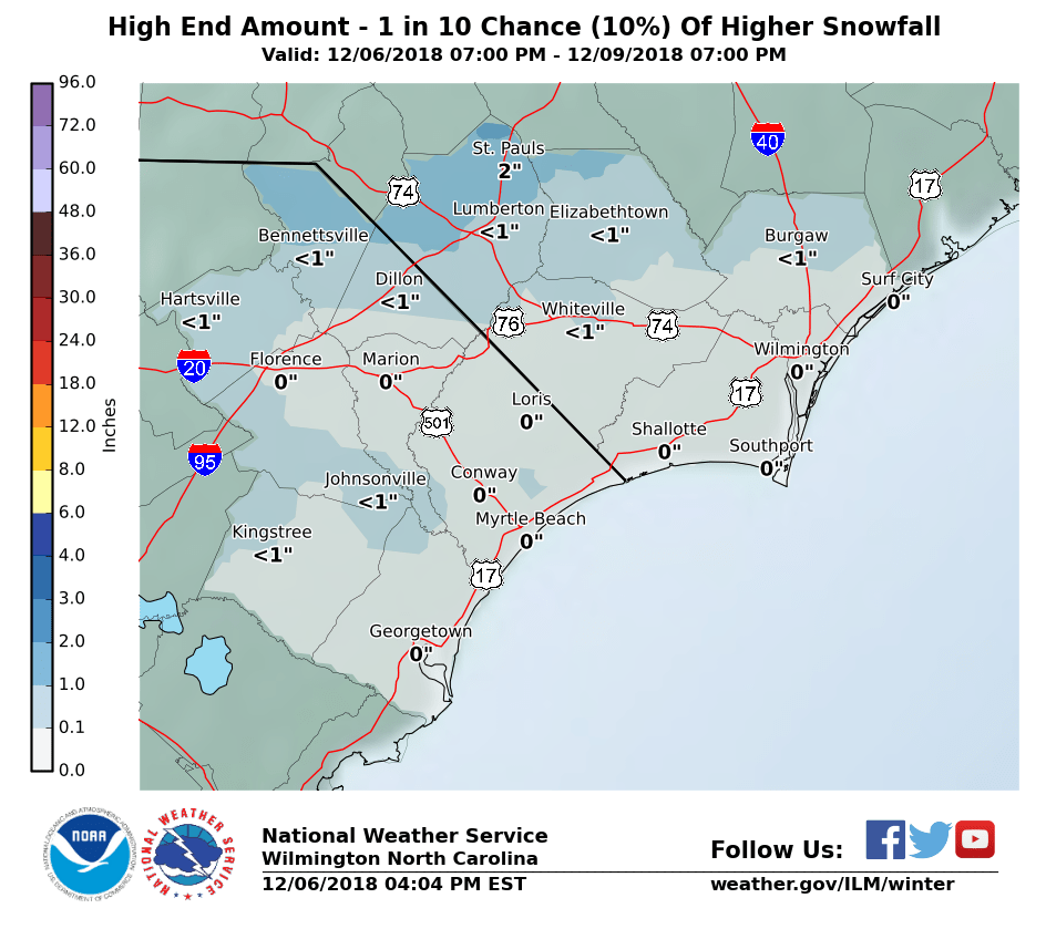
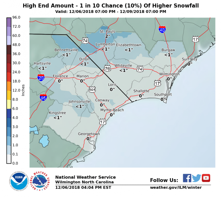
@Orangeburgwx, We have a 1 in 10 "chance"..
-
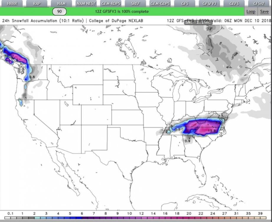
12Z GFSFV3 (Maps) Hours 24 hour(s) accumulation precip vs AT Hour 75 forecast (Hope this helps)..
-
He, (Wow),, said it not I mean again,, NOT *I* ,, did you hear this? @Orangeburgwx & @tramadoc??? (Not too raise our hopes or anything.. ).. but that's really, saying something.. when the MOD mentions this.. wasn't 89 a El Nina year? (edit for correction)
-
MORRRRRR SOUTH @downeastnc 125 miles!
-
Dear @SantaClause ,, Can I , (and some of Us southern folks), get a 75~125 mile shift SOUTH by SouthWest with the LP? We not asking for much..
-
2018/2019 Mountains and Foothills Fall/Winter Thread
SENC replied to Tyler Penland's topic in Southeastern States
Nice! While I had muh windeers open here at the Coast today, (airing out the house).. Like night & Day -
Regarding "Our" upcoming "Storm".. For those interested, like @tramadoc, this "storm very well could put WILM over 100" of precip for the year.. Looking for "backside Flurries" @Orangeburgwx for us, No accumulations then back to the 50's & 60"s.. (UNLESS).. MOR Suppression! KILM NWS AFD for those interested, this Disco could "help" with Forecasts upstate.. Storm system will affect the local area this weekend with a potential for periods of moderate to heavy rain Saturday through Sunday, and lingering through Monday. Right now we are looking for 2 to 3 inches total over the weekend, bringing our rainfall total only couple of inches shy of breaking the 100 inch mark for Wilm. High pressure will build down into the Carolinas from the north as potent low pressure system tracks across the Gulf Coast this weekend. Winds will increase through the low levels on Saturday, leading to increasing isentropic lift heading through the weekend with rain spreading northward into the Carolinas on Sat. Expect periods of potentially moderate to heavier rain Sat night into sun as the low lifts up along the southeast coast. Any mixed pcp should remain farther west and north in the cooler air through the weekend. The current track tracks the low right up along the southeast, remaining just offshore, bringing the center just off the Cape Fear coast Sun night. As it lifts off to the northeast Mon night, shortwave energy will dig down clouds and pcp will wrap around the back end of the system as it lifts off to the northeast Mon night. This will coincide with decent cold air advection and temps should be borderline mainly west of I-95 for some mixed pcp. Therefore some flurries or snow showers are not out of the question overnight Mon. Temps will be moderated by clouds and pcp through much of the period with overnight lows generally in the mid 30s to around 40 and day time highs in the 50s. The sharpest temp gradient should occur Sunday as the low tracks up the coast pulling shallow cool air down from the north inland and pushing warmer and moister air onto the coast. Temps may not reach past the 40s west of I-95 on sun, with temps closer to 60 along the coast. Clearing should occur through tues in deep cool and dry northerly flow on the back end of system. That said & posted, I wish all the Upstate Folks the Best of Luck, Post a lot of Pictures!
-
Is It ok to use this? for Useful analysis? (Is this page allowed)..?? My sincere Apologies if it isn't..
-
I'm finding this kinda hard, (FV3-GFS )(believing), that LP "jump" way off New Orleans into way up into Miss on the 114 panel.. Then WAAY off the coast on N.C. on the 120 panel..
-
excuse Me @Mods for attempted Humor, I'm feeling good tonight for everyones chances..

-
@Orangeburgwx, went from Jack stands to a 4 post lift! We got that Bait spread in the Propwash dern it!!
-
@Orangeburgwx & I are still "fishing" Nice Spread of Baits out, Trolling & wait & see, 25 degree dew(s),, Lower, south & deeper.. Otherwise I hope you Folks Up state get IceAgeSnow(s).. Enough to start a Glacier! As always We might have to "wait" on the backend here.. KILM says
-
@tramadoc, Here in the Wilm area We are at, (as of Dec 3rd) SINCE JAN 1 95.83 INCHES YTD ,,, NORMAL VALUES are 54.34" With "Departure from "Normal" is 41.49" inches This incoming Storm Should put Us (almost) over the 100" inches for YTD... If this is the New "normal",,,, Maybe,, I should consider growing RICE next year.. Think, (I looked this up),, Colon, Panama averages around 98 inches per year..
-
I think He meant this? Sorry couldn't resist..