SENC
-
Posts
892 -
Joined
-
Last visited
Content Type
Profiles
Blogs
Forums
American Weather
Media Demo
Store
Gallery
Everything posted by SENC
-
Present DATA.. Don't try to Silence someone presenting Hard Data.. See that ya'lls problem.. Trying to "Silence" someone whom offers different opposing views.. Or try to get them "banned".. Theres Religious cults/Goverments that tend to do such things..
-
You did NOT even read the links (DATA) presented, then call it Cherry-picked,, great , OR FAIL on peer Review.. It was over-hyped.. Making "excuses" on buildings that are NOT, or WERE NOT, "constructed" up to CURRENT building codes isn't Making excuses.. It's called facts.. I presented MY Data NOW present yours, or Shut ______..
-
Apparently @yoda did you look at the inserted picture? TRY reading the Highlighted parts..
-
Thank you, I assumed it was directed at me, My sincere Apologies..
-
Then present your DATA, so WE ALL can peer review BOTH Data sets and reach a Scientific conclusion? Instead of trading insults?
-
How about reading the links instead of insulting someone?
-
I'm not a troll.. was just "staying on Topic".. I had the wrong winder open, that I was typing in thus,, my mistake.. This is BANTER correct? So I'm posting in BANTER now, giving support & hard FACTS & DATA that only supports a CAT 1 Hurricane.. Yes, I'm not going along with ___________ .. I have different views that are supported with FACTS.. So ya'll want to insult & Ridicule Me.. When FACTS are staring you in the face.. That's all good, I got thick skin.. Though actual observed & recorded data doesn't LIE..
-
Have seen Ariel photos of Mexico beach. You completely wrong dude. You really need to be banned by mods. I have a scientifically different view(s), Not going along with Groupthink So BAN HIM! Burn Him at the Stake,, SILENCE! Just throw out "peer reviewed", Science, since it doesn't agree with your views & feelings.. Sheesh! Probably napping. Gramps gets cranky when he forgets his oatmeal. Don't agree? well,, insult & deflect... One Who disagrees with your views. Sounds some some , Pantyfa talk IMOP... The TV was, of course, showing everyone all the "horrible damage." Except it wasn't.As the TV news anchor was "breathlessly" reporting on how horrid it all was in the background were houses and other buildings standing tall, proud and undamaged -- they had their roofs, walls and windows all up and not one board in evidence on any of the windows either. Cat 4? My A** . HAD that been a Cat 4 every one of those ordinary stick-built houses would have been LEVELED and for those that were reinforced concrete (e.g. ICF) every single window and roof would have been trashed. They weren't. Oh sure, you can find the collapsed garage or half-built building that came down in dramatic fashion. It was half-built and not even half-strong! Again this was a 'strong" Cat 2 the Data I'm finding support My conclusion.. Michael has been hyped beyond what it really was. Thankfully, it appears from the real data that the storm was not a Cat 4 hurricane. This official NOAA Panama City coastal station, https://www.ndbc.noaa.gov/images/stations/pcbf1.jpg , https://uploads.disquscdn.com/images/c7773e46b15321267a4160187c5a46920b83be25bfc9a0799867ea0c4b3ecb12.png , recorded a maximum sustained wind speed of 53.0 knots, which is 61 mph, which isn’t even Cat 1 windspeed. Here are screen captures of the station data during the maximum recorded wind speeds: https://uploads.disquscdn.com/images/6e27cb15d7d36907f76c4f3065fd8d21c4f5fc84f6ad81a6c3781db63765284a.png Note the maximum 53.0 knots (61 mph) at 3:06 pm. The nearest NOAA buoy to the east of Panama City, APCF1, recorded a maximum sustained wind speed of 54.0 knots (62 mph), which is also not even a Cat 1 hurricane. Here is that station: https://www.ndbc.noaa.gov/station_page.php?station=apcf1 Here is a screen capture of the wind speeds recorded during Michael’s landfall: https://uploads.disquscdn.com/images/326b1c9af4e01c28f2e9cb993c8047d2c01da8b3b95a4ea26e9e73b39bd05ddd.png Note the maximum sustained winds of 54.0 knots (62 mph) at 1:06pm. Here is the closest NOAA station, SGOF1 , to the east of Panama CIty which is out in the Gulf, unaffected by land, https://www.ndbc.noaa.gov/station_page.php?station=sgof1 This wind speed measurement is at 35.1m above surface, which would measure higher windspeeds than the official 10m height. Here is a screen capture of the max wind speed history of station SGOF1: https://uploads.disquscdn.com/images/33c575eeac8f491f600fa4a3d2525aa130374cc28fdaee20ed7749a5f340ea9e.png Max sustained wind speed of 61 knots (70mph) between 11an and noon. Here is the wind speed history at a Panama City Beach weather station: https://uploads.disquscdn.com/images/490679e6111aad721b1ae3d686ef11958faccaef1a8c13f3703e58a5ed49c6a2.png Maximum wind speeds of between 70mph and 75mph. Here is another wind speed history at Panama City Beach: https://uploads.disquscdn.com/images/d0c67684db3570bc8b7c68734886635a93e0cbec4071a250fa50668bce83f6a2.png Maximum wind speed of 76.1mph, barely Cat 1. This actual data seems to indicate that Michael was hyped beyond what it really was. So where is the hard wind speed data confirming that Michael made landfall with Cat 4 windspeeds of greater than 130mph to 153mph??? Can anyone link to any hard wind speed data confirming Cat 4 windspeeds? Not just reports, but actual documented DATA? Oh wait.. NOAA claims 150 mph sustained winds,, but also reports gusts up to 119 mph. Doesn't seem credible. On its face Value People ( Storm Chasers / Reporters ) where driving around in the streets, some hiding behind building posts, and then came the assine comparison that the “Millibars” (Atmospheric Pressure) had become [ GREATER THAN ] Hurricane Andrew, all this while people are still driving around while others hiding behind buildings/posts, AND… No-Where, at anytime, Did I hear ANYONE DeclareANY Sustained winds greater than,,, wait for it... 105 mph Each & everyone of you seem to Forget the Majority of the construction there is 30+ years old.. Mobile Homes & Homes construct back then were & are built without HURRICANE STRAPS ,, that were enacted to the building codes after Andrew.. you know those lil metal plates that secure the Roof too the Walls? Yeah those.. The majority of the buildings & homes in reality were NOT up to current building codes ,,, That said.. I think it's about time for to sack and burn the Sacred Temple of Climate Religion, and gut the staffing of the NHC and NOAA among others, and put true scientists in place--not peer-reviewed, Algore approved pathological liars that we have at present. Guys that prove stuff through science. Without fudging the data. That are OK with being wrong, when they're proven wrong. A guy can hope, at least. Meanwhile, I'll get ready for winter. Turns out I don't mind the snow much. It doesn't mess us up anywhere near as bad as even a Cat 2. I have errands to do.. Ya'll have a God Blessed Day..


-
I can do the same.. Strong cat one before it rolled over MY HOME.. (I was 7 miles from landfall).. Florence dude..
-
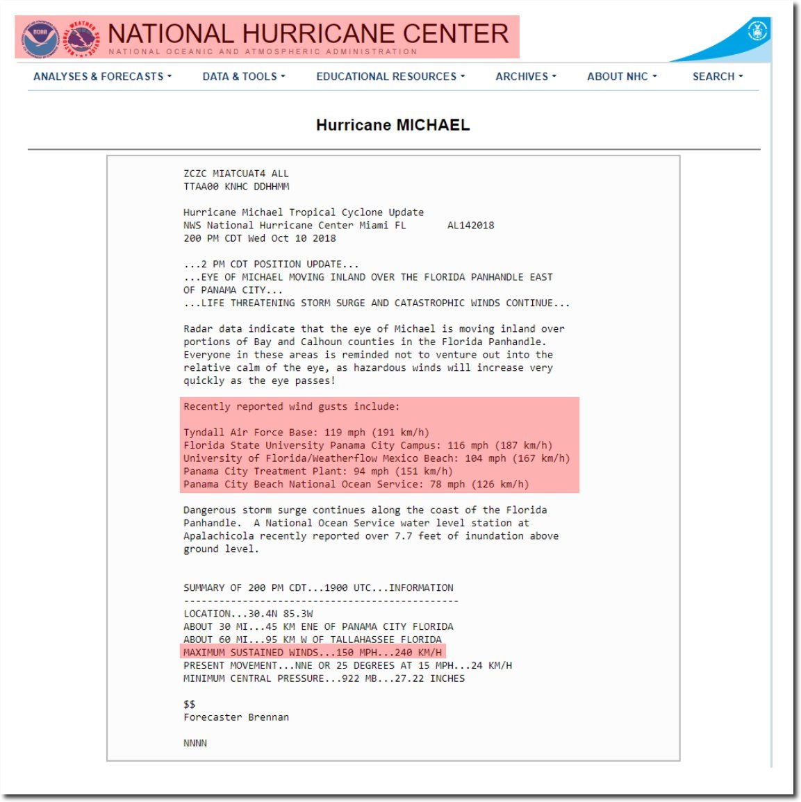
“Recently reported wind gusts include: Tyndall Air Force Base: 119 mph (191 km/h) Florida State University Panama City Campus: 116 mph (187 km/h) University of Florida/Weatherflow Mexico Beach: 104 mph (167 km/h)” The differences make sense, since Tyndall is right in the firing line, however in the summary: “MAXIMUM SUSTAINED WINDS…150 MPH” I guess that must be historical, somewhere out where it would affect only boats and seagulls. Incidentally the original link: https://tidesandcurrents.noaa.gov/met.html?id=8729210 Now reads maximum gusts of 76kn and sustained of a “terrifying” 42kn
-
The ilm County Warning Area will continue to remain in the favorable location for embedded quick tornadic spin-ups beginning prior to sunrise Thu and continuing until Michael's center pulls away to the NE by late Thu aftn or early evening. No major changes need for temps. coastal Flood Warning for Brunswick coast as strong on shore winds are expected to cause moderate flooding during high tide on thurs mid to late morning. The latest official NHC forecast brings the center of Michael across the inland County Warning Area in the 16-20z Thursday. With its approach, surf conditions will continue to deteriorate, with breaking waves likely to reach as high as 8 feet on Thursday. Therefore a high surf advisory has been raised and will remain in effect into Thursday night. For the remainder of today and tonight, guidance and radar trends indicate that shower activity will remain scattered in nature. However within those showers, the potential will exist for brief, very heavy rain, and a Flash Flood Watch remains in effect through 2 am Friday. As Michael accelerates to the northeast and approaches the eastern Carolinas, rainfall will expand in areal coverage from SW to NE beginning Thursday morning. The highest rainfall amounts are expected to occur west of the I-95 corridor, where 3-4" amounts will be common, but locally as high as 5-6". These amounts will trend lower further east, with an average of 0.75-1.0" along the immediate coast. Much drier air will wrap around the back end of Michael in deep northwest winds. Complete change in air mass as pcp water values will drop down to less than a half inch by daybreak Fri. Looking forward to fall temps!
-
Still 23 mph Sustained winds SSE here light rain, here in Carolina beach..
-
Honestly, I wish We could get @LakeEffectKing & @donsutherland1 to chime in their thoughts here.. I trust those 2 guys to give very UN~Biased, & honest answers.. (No guys I don't wanna have too drag ya'll into this debate).. Though.. that said.. What I seen & monitored via the Sea buoys Data sets , (NOT what the NHC said) discarding those.. Actual Marine conditions.. The "actual video(s) from "landfall" .. AND based on My own experience,, This was a Strong Cat 2.. Hurricane watcher & survivor on SENC Coast since 1969..
-
NO your "reading comprehension" skills are less than Steller.. I SAID you will not SEE DAMAGE, as portrayed in those pictures above.. For the "current" landfall se habla español.. A Cat 2 made landfall.. NOT a "Cat 4 or 5".. I explained Why you _______.. 8 & bait.. OBX Bound..
-
Don't be a grammar Nazi.. as long as I get my point across.. well,, your a youngin,, I can tell. ALL you youngins, that's what you do, attack, old school Folks.. guess it's the new way of thinking & ciphering I assume,, Anyway, you cannot give Me a answer.. those pics ARE from a Cat 3 & 4.. We'll NOT see that tomorrow, via *Ariel's* because WE ONLY got a strong Cat, 2.. That's it.. NHC isn't *GOD*.. They been "politized" ..
-
Do you know what you are even looking at? ( I think you are in your younger TEENS Myself) you have a lot to learn My friend.. These picture are about 17 years old..
-
I see, Slabs Will we on a over flight? I doubt it
-
Folks might want too imply.. Well look at the "roofs" flying off blah blah.... [/I] I have a answer too this.. Where "Michael" made "landfall" was in fact Historic .. NO Landfall from a "major" much less a Cat 1 or 2 in about 30 years.. Building codes were not in effect for those older homes, they lacked Hurricane straps.. Grandfathered in.. Plenty of Old Mobile Home parks, (For seniors) are/were still there.. Just my 2 cents.. Again this was no stronger than a cat 2, .. I Have a team put together this evening to prove it so.. Based on DATA..
-
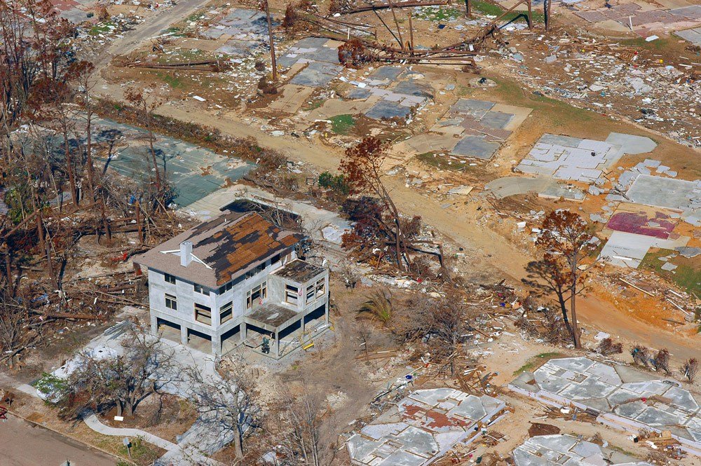
If this was even a "Cat 4 or even a Cat 3",, THIS is what We would be looking at.. I'm not seeing it here.. As far as Michael..
-
Well seeing how it got "deleted" here your Magical eyewall shot, (I cannot verify), looks legit to me..
-
LOL always.. Peace, roll up one & smoke it up for Me..
-
I'm finished.. just had to get the "above" off My chest.. thanks for listening.. Looking & searching for Fall.. and epic FALL FISHING
-
Smoke one 4 me
-
Strong Cat one.. I'm seeing the exact same damage.. (Yes I went through the eyewall of Florence), I reside 7 miles from landfall..
-
1.000,000.00 /SARC