SENC
-
Posts
892 -
Joined
-
Last visited
Content Type
Profiles
Blogs
Forums
American Weather
Media Demo
Store
Gallery
Everything posted by SENC
-
LOL WE said that in the first of JULY!
-
Ya''ll are "crying" over rain? you should check the stats for WILM,N.C. for the past month!
-
Monsoon continues.. That is all
-
Even though We are now trending LOWER in the Rain forecast Dept. Monsoon still continues. 15 out of the last 16 Days Wilmington & surrounding areas have received Significant rainfall.. As of the end of Tuesday, the final day of July, Wilmington has officially recorded 57.1 inches of rain in 2018. Average for the entire year is 57.6 inches, Current conditions & Obs Broken Clouds & Heavy Downpours 79/83 Current Temp 82f Humidity 85% Dew point 77.0 % Winds out of the South 0~3 mph Precipitation 1.05 inches
-
73/80 currently 80f Broken Clouds Winds South @ 0~5mph Humidity 89% Dew Point 76.3 % Pressure 30.11 inches 0.55 inches Rainfall today, as of 1:40 PM As of the end of Monday, July 30, Wilmington has officially recorded 55.9 inches of rain in 2018. Average for the entire year is 57.6 inches! At this rate, the Port City stands an excellent chance, sometime later this year, of breaking its all-time annual rainfall record of 83.7 inches - set all the way back in 1877! (NOTICE the RECORD DATE?) It was during the *Maunder Minimum* The National Weather Service continues a Flash Flood Watch for Brunswick, New Hanover, and Pender counties through midday Tuesday. With saturated grounds and the threshold for flooding so low, any spells of heavy rain may result in a poor-drainage or lowland flooding. Please stay alert! Most of the main-stem rivers are in their banks, but the National Weather Service maintains a Flood Advisory for the Northeast Cape Fear River at Burgaw. With the river hovering between 8.5 and 10 feet through at least the first weekend of August, flooding will continue in the River Bend and River Birch areas. TUESDAY FORECAST DETAILS: Another day: another deluge, at least for parts of the area, as tropical moisture feeds in from the south. Scattered showers and storms will present localized flooding, lightning, and wind issues. Otherwise, expect variably or mostly cloudy skies, light southerly breezes, and highs mainly in the middle 80s. LONG-RANGE FORECAST HIGHLIGHTS: Scattered flooding, lightning, and wind issues may continue, but as the Bermuda High builds westward toward the Carolinas, daily odds for showers and storms will tend to decrease: 50% Wednesday, 30 to 40% Thursday and Friday, and 20 to 30% this weekend. Daily highs: mainly 80s. Nightly lows: 70s.
-
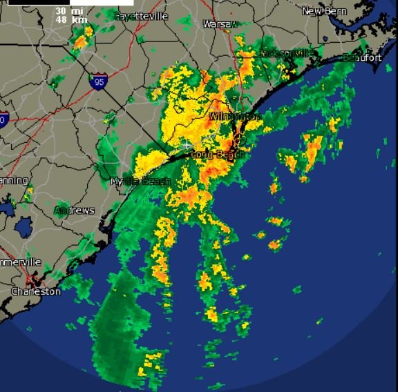
Here are some of the rainfall totals as of 8:30 PM. 7/30/2018From the National Weather Service Forecast Office - Wilmington, NCTHE FOLLOWING ARE UNOFFICIAL STORM TOTAL RAINFALL REPORTS OF GREATER THAN TWO INCHES FROM THE MAJOR RAIN EVENT THAT HAS BEEN AFFECTING THE AREA THE LAST TWO DAYS. AMOUNTS ARE FROM NWS OBSERVATIONS...FAA OBSERVATIONS...CO-OP OBSERVERS...COCORAHS SPOTTERS...AND THE PUBLIC. NORTH CAROLINA...BLADEN COUNTY...ELIZABETHTOWN 5.79BLADEN LAKES STATE FOREST 6.02ELIZABETHTOWN 6.2 NW 5.34BLADENBORO 2.0 NNW 4.95WM O HUSKE L D 4.72CAPE FEAR LD1 4.81BAY TREE LAKE 3.42...BRUNSWICK COUNTY...LELAND 5.7WSW 14.60SUNNY POINT MILITARY TRMNL 13.75SUNNY POINT 10.91BOLIVIA 10.44SUPPLY NATURE CONSERVATORY 9.92SUPPLY 8.49SUNSET BEACH 2.9 NNE 7.81BALD HEAD ISLAND - WEST BEACH 8.63TURNBULL CREEK 5.71OCEAN ISLE BEACH 5.31SUNSET BEACH 1.7 WNW 5.21LONGWOOD 4.34SUNSET BEACH 3 N 4.99...COLUMBUS COUNTY...WHITEVILLE 7 NORTH 8.99WHITEVILLE 6.3 NNW 7.84 WHITEVILLE 2 WEST 5.76WHITEVILLE 0.3 SE 4.78WHITEVILLE 7 NW 4.84WHITEVILLE 4.69WHITEVILLE 5S 4.32...NEW HANOVER COUNTY...WILMINGTON 18.09WILMINGTON 18.33WILMINGTON STATE PORT 16.00WILM - ALAMOSA PLACE 12.89OGDEN 13.76SILVER LAKE 1.3 NE 11.70WILMINGTON 7N 11.60WILMINGTON 7SE 10.80WILM - KINGS GRANT 11.17MONKEY JUNCTION 11.50 MASONBORO 14.60WILM - HALCYON FOREST 11.34BACK ISLAND 9.08WILM - MIDDLE SOUND LOOP ROAD 10.18WILM - COURTNEY PINES 9.50OGDEN 11.03MASONBORO ISLAND 6.89...PENDER COUNTY...BURGAW 4E 13.40BURGAW - EDGEWOOD 12.80 HOLLY SHELTER - BACK ISLAND 11.20MOORES CREEK NB 7.89SURF CITY 7.43ST. HELENA 8.03WATHA 7.41N TOPSAIL BEACH - MARKER 3 7.16...ROBESON COUNTY...RED SPRINGS 8.80 ST. PAULS 0.6 NW 7.65 LUMBERTON 5.12 LUMBERTON - FAYETTEVILLE RD 5.27 LUMBER RIVER SP 4.21 LUMBERTON 3SE 3.75 MAXTON 4.46 ...HORRY COUNTY...MYRTLE BEACH 5.3 W 8.18 MYRTLE BEACH 9.7 WSW 8.67 SOCASTEE 6.34 LORIS 5.60 LORIS - FARM AT FOX BAY 6.04 CRABTREE SWAMP 5.37 GALIVANTS FERRY 4.81 MB - CAROLINA FOREST 6.42 NICHOLS 4 EAST 5.78 NORTH MYRTLE BEACH 5.12 LORIS 4.57 CONWAY 2.70 http://www.wect.com/story/13241636/robb-template-rhe
-
Been Huffin & puffin to blow some of this off the Coast up ya'lls way! J/K..
-
Mini Ice Age? You brought this with you correct?
-
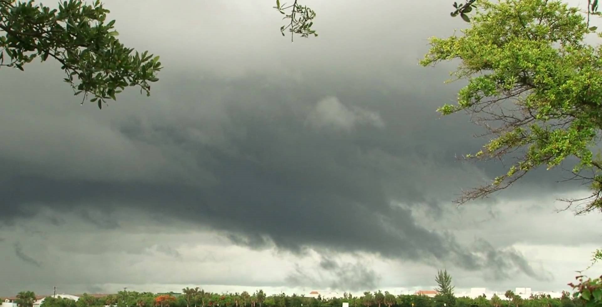
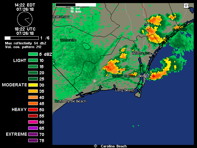
Since this Mornings Early report We have received TODAY, (I averaged this out between Weather Stations from the beach to the "Official readings" at the KILM Airport).. About 10 weather Stations around New Hanover Co.. Carolina/Wrightsville Beaches, and Neighborhoods, (including the State Port & UNCW), and between them & the Airport.. In addition too, what I reported Early this morning, which Is about 5" + inches, rain amounts included since yesterday Is around 3.0" +/- inches.... Today alone,, there's still a few hours to go until 12AM.. IMBY I got 3.27" today, AFTER My report Early this morning 2.20,, + 3.27(today) = 5.47" inches of Rain IMBY Since yesterday afternoon.. Around WILM Some MORE and SOME Less.. Broken clouds & STILL light rain in the area(s).. Peaks of "Sun" between the cloud deck(s).. Constant Thunder in the Distance.. If not overhead.. So... Current Obs.. 73/81 Currently 81.. Humidity 84% Dew point 75.4% Pressure 30.07 inches Winds. SSW 0~3 mph Water temp still at 83F Updated AFD... through sunset: numerous showers/tstms continue to fire across the interior late this afternoon ahead of the sea breeze. This activity will gradually move east, possibly reaching the interior coastal counties before weakening. Locally heavy rainfall and minor flooding remain the primary hazards along with gusty winds and cloud-to-ground lightning. While an isolated strong/severe wet microburst can not be completely ruled out, the overall risk for severe weather remains low. Tonight: low-level convergence will gradually shift back east into the Atlantic later this evening as sea breeze dissipates inland and winds pick up over the coastal waters. A rich, tropical environment (pwats over 2 inches) will remain in place so expect convection to reignite over the coastal waters by late evening and spread to the coast overnight as the low-level flow veers slightly. This slight veering would direct much of the heaviest rainfall back into the southeast North Carolina and possibly as far south as the grand strand early Tuesday. In fact, several of the various cams, including the h3r and high res arw, show a similar heavy rain signal to what occurred this morning where flash flooding was observed in the Carolina Beach area. Given the current wet antecedent conditions and that another heavy rain signal is observed in a number of the cams, a Flash Flood Watch has been issued for Pender, New Hanover, Brunswick and coastal Horry counties through noon Tuesday. Rainfall amounts of 1-3 inches will be possible in this area with localized amounts in excess of 4 inches. Oh MORE JOY
-
Lordy @Shaggy, even a "Mild" TS & were F***…..
-
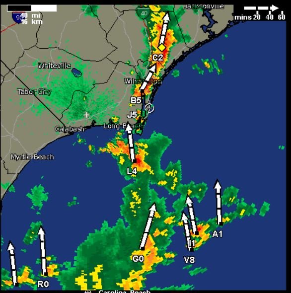
Flash Flood Warnings going up everywhere here, alerts on TV/Radio/Cell Phones.. Looks like these are going to be training T-Storms again.. Massive Heavy Downpour(s) ATM... After the 2" in the last 24 hours AND all the rain We had this Month... Send LifeBoats ASAP!
-
By the end of the week,, SENC should either be Dark Blue, or Violet..
-
Since yesterday Heavy Down pours with Thunder & light Showers have persisted since I posted yesterday.. 75/81 Humidity 93% Dewpoint 72.5% Pressure 30.09 Winds SSW @ 3mph Precipitation in the Last 24 hours, 2.10 inches 15.00" even Month to Date (for July) Average is 6.50 +/- Current conditions 74F Cloudy & light Rain Beach Water Temp 83F I thought I saw DownEast Floating SouthEast, by the pier on beach Cam awhile ago... In His Ark... this mornings AFD.. Oh Joy as of 300 am Monday...the synoptic pattern has not changed in the past 24 hours. High pressure entrenched over the Atlantic and a developing trough to the west. The 850 mb gradient tightens this morning and the models develop a 20 to 25 knot jet which will continue to pump the moisture into the region. This deep tropical moisture is reflected in the precipitable water with values between 2.0" and 2.5". Currently a strong short-wave trough is moving north along the coast and will shift north of the area during the morning. Other weaker waves are seen in the models but confidence with their timing is not high but with the instabilities of 1200 to 1600 j/kg, convection will continue to develop through the period.
-
MONSOON CONTUINUES Jesus I feel like I'm back in Panama during the RAINY SEASON Seriously! Have T-Storm(s) training on top of ILM since yesterday afternoon.. PLEASE send help to build ARK I'm betting Downeast is getting as much as I am,, current Radeer shows storm's "training" all the way to New Bern.. Not posting "totals yet.. Current Temp is 75F that is all.. gurgle gurgle…. (Hey I'm sporting GILLS! )
-
SHILOH, N.C. (AP) — Heavy rainfall in North Carolina has diversified the farm of one family, who found fish flopping in between their rows of soybeans.The Observer reports a video posted on Facebook by Pasquotank County officials shows foot-long fish swimming through the rows of soybeans. The video was filmed by Carolyn Jennings on Tuesday afternoon, and has been viewed around 76,000 times. The state has seen record-breaking rain in July, particularly around coastal areas that measured nearly a foot of rain since July 20. More than 16 inches of rain have been recorded this month at Cape Hatteras by the National Weather Service, breaking a 1949 record. Flooding from runoff has enabled fish to leave their native creeks and lakes. One family caught several off their back porch in Manteo. **Tailing Red Drum Folks! **
-
So ,, Monsoon Season thus continues? Synopsis... a front will remain west of the area through the weekend into early next week. As a result, humid and unstable conditions will continue with a chance of showers and thunderstorms each day. The coverage of storms will likely increase the first part of next week as upper level impulses move across the area. Flow through much of the column is from the SW, which is keeping pwats over 2 inches, highest near the coast, which combined with latest rap analyzed MLCAPE of 2500-3000 j/kg has allowed scattered tstms to develop across the area well into next week. Welcome to the SouthEastern States Rainy Season

-
Today... 82/74 Humidity 84% (finally had to break down & turn the AC on because of the Humidity, it was getting quite "thick"..) Dew point 76.3% Pressure steady at 30.03 inches Winds SSW are CALM, (even though We had several waterspouts in area waters yesterday & today!) Precipitation Today 0.35" inches and just under a Half inch total in the past 24 hours since I posted yesterday recorded.. Precipitation for the Month of JULY now stands at 12.93 While Monthly Historic average on this date is.. 6.27" and YTD Historic average is 30.55 respectively.. (going by ILM stats.) Beach water temp steady @ 83F Monsoon season continues until at Least through Thursday,,, NEXT WEEK? AFD Synopsis... a front will remain west of the area through the weekend into early next week. As a result, humid and unstable conditions will continue with a chance of showers and thunderstorms each day. The coverage of storms will likely increase the first part of next week as upper level impulses move across the area.(My edit; can it get more "increased?" than it is now? Reminds Me of ATL Side of Panama during the rainy season! ) pwats over 2 inches into next week which combined with latest rap analyzed MLCAPE of 2500-3000 j/kg has allowed scattered tstms to develop across the area into next week.. UUGGGHHH My Rice Paddies are doing great..
-
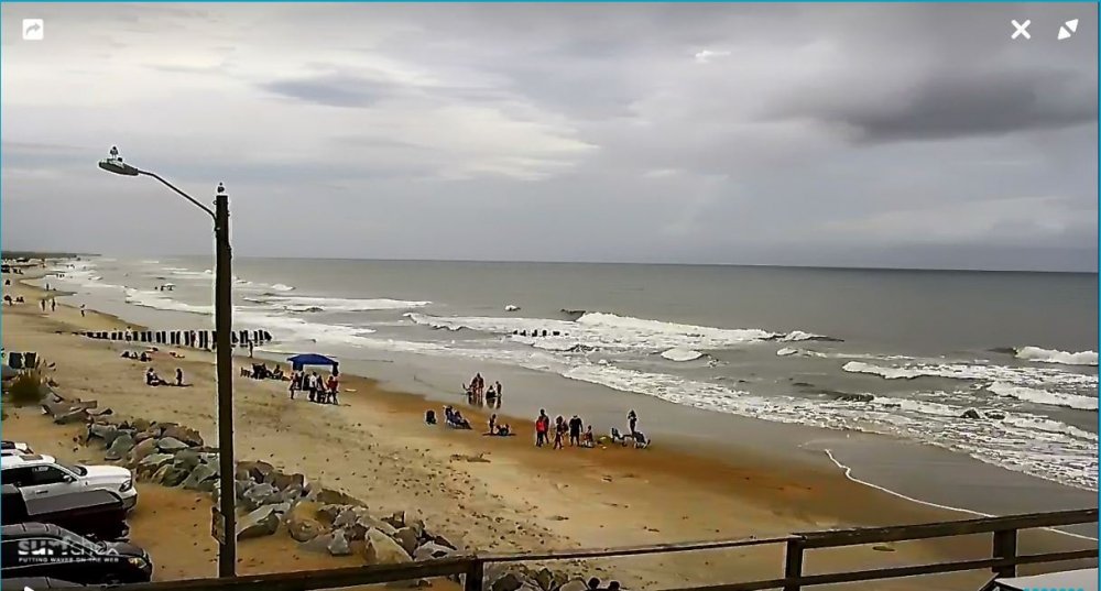
LifeGuards have "shutdown" Our beaches down south here also,,, DownEast.. We've had numerous WaterSpouts also spin up down this way too! (I'm sure ya'll have had your share up that way to!)
-
Pretty cool "RoadTrip" yesterday from Wilmington to RDU & back.. Raining T-storms here, and the futher inland one went, the Less clouds & rain there was.. (Except around the RDU Airport yesterday w/Rain & Fog on I-40) going back home Nice Day, partly Cloudy, as I approached the coast, the More "numerous" Showers & downpours became.. Then as I, cross the Pender Co. into New Hanover Co line coming into ILM, it was totally "socked-in" as We are STILL this way today.. OK.. that said... Current Obs.. Cloudy & area T-storms 82/74 (Currently 79) Humidity 85% Dewpoint 73.9% Pressure 30.02 inches Winds are SSE (but CALM Most of today) Beach Water Temps is at 83 Precipitation yesterday 1.20 inches Today .30 inches Precipitation for the Month of JULY 12.34 Average is, 5.94" YTD is 52.38 Here is a cool Gif I just got for My area(s) check-out the Seabreeze/outflows going on.. These Storms have been just setting/training on top of us all Day today From the AFD as of 3PM today as of 3 PM...well, despite being less active than much of the week, showers and thunderstorms have once again affected mostly coastal areas today, adding to impressive monthly and yearly rainfall totals. This activity has developed along the sea breeze and other outflow/residual boundaries, aided by 300mb diffluence as a jet lifts off to the NE, and shortwave energy thanks to weak impulses rotating within the flow.
-
KILM/NWS had this to say, in this Mornings AFD.. On a side note, the ilm ASOS has now surpassed 51 inches of rainfall for the year so far. Normally this amount is not reached until during November!!!
-
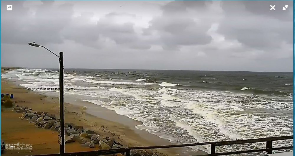
75/81 Humidity 88% Dew point 70.0 % Precipitation (For today).. is at 1.38" Pressure 29.98 inches Currently a LIGHT SHOW & heavy Rain Showers & Thunder Storms.. Todays Peak Wind Gust was 33.1mph Early this morning.. Current Winds Are SSE @ 10 MPH Rip current Risk is still |HIGH]
-
81/71 Humidity 90% Dew point 77.7 % Pressure 29.90 Scattered clouds/overcast Todays Peak Wind Gust 55 MPH Winds currently SSE @ 21 MPH Beach Water Temp 84 1.40" precipitation Early this Morning with a "lightshow"... Rip Current Risk HIGH
-
My "Rice Paddy" is doing great here on the Coast..
-
68/95 for yesterday, (July 21st).. Today, (thus far)… 12:25 AM on this Sunday July, 22nd, 2018 77/... Clear Skies Humidity 88% Dew point 75.6% pressure 29.83 inches Winds.. SSW @ 13 mph Beach Water temp is at 84F We got 1.05 inches of Precipitation on Thursday..
-
28? Tornado Reports? #Outbreak? Wow.. I read somewhere there was just a SLIGHT chance for #severe WX in those areas today?