

SENC
-
Posts
910 -
Joined
-
Last visited
Content Type
Profiles
Blogs
Forums
American Weather
Media Demo
Store
Gallery
Everything posted by SENC
-
Don't wait until the last minute.. Gas cans will be gone" AND" no gas to be had.. do it NOW..
-
I and DownEast,, Digress.. I'm sure He agree's I hope pulled he button on that genset. I started mine.. got gas cans at the ready ..
-
I'll try too answer this.. I purchased, a B & S "storm responder" from Sears.. 5K~6K watts.. Runs 11 hours on 5 gallons of gas.. (depending on the Load Cycle).. It is enough, I "TESTED" Loading on my home.. I was enough to power My computer/freezer/fridge/TV/ AND My AC/Heat pump.. (Barely all @ once).. I also had a Generac 6000 that could do same amount of "load" , but less hours run time.. Hooking one up... YOU CAN USE THE 120/240 "LINE OUTLET" TO Reverse plug per'se, into your DRYER outlet... making it a "inlet" into your home powering it. DOING SO MAKE SURE YOU TRIP YOUR MAIN BREAKER TO THE GRID!!!!!!! aS "YOUR POWER" will go to the nearest transformer turning your measly power into 7K +/- volts possibly causing death too line workers thinking those power lines were not "energized"... My house is "wired" for a Gen-set already.. All I have to do is trip My breaker & I'm set.. Generator runs in the detached garage.. Of course FOLLOW SAFTEY GUIDELINES, in other words Carbon monoxide poisoning.. Smaller portable generators (1000K ~ 3000K watts) are enough to power your fridge/freezer and maybe light & TV/Radio.. Though the extension cord outlets, (don't forget to buy those, AND long enough to have the generator OUTSIDE.. ) Edit too add, (about the transfer Switch on breaker panel),, I just cut the Main breaker.. I carry about 20 gallons of fuel, because I'm right on the main grid.. Generators are great to have in winter, In case of Ice Storms also.. Be sure (If you buy one) buy your gas cans NOW, you'll have mucho trouble finding some.. Plus I got a Boat tank that hold 30 gallons if I've got to use that too..
-
Cape Fear Lock
-
Well this is Interesting... Moreover, Arctic mid-summer temperatures, north of 80°N latitude, have dipped to near freezing over the past days. This is likely in large part linked to the cold North Atlantic sea surface temperatures we’ve been witnessing. All this suggests ocean cycles, and not CO2, are the real Arctic drivers. Snow and ice climbing past decade The cold polar temperatures are naturally having an impact on Arctic snow and ice. Japanese blogger Kirye tweeted here that Arctic sea ice volume is currently at the 4th highest level since 2003, thus defying the dire alarmist predictions of Arctic sea ice disappearing by now. ------------------------- 40-year veteran meteorologist Joe Bastardi at WeatherBell’s Saturday Summary shows how the Earth’s surface has cooled dramatically over the past three years and that Arctic sea ice is piling up. http://notrickszone.com/2018/07/15/global-sea-sea-surface-temperatures-have-seen-pretty-dramatic-turnaround-says-40-year-meteorologist/
-
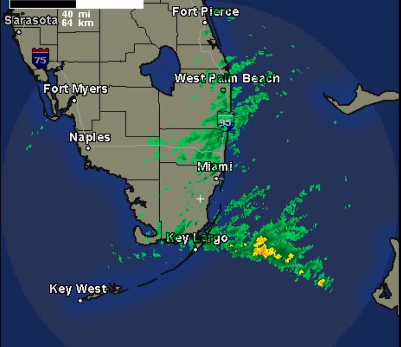
Like this? Convective T-Storms firing..
-
Har! Har! Har!!!!! OMG YOU are so friggin right!!!!!!! Congrats to those that got a "dusting of snow" especially,,, to those that got good amounts.. For all the others.. We down this way don't get hyped up at ALL.. As We hardly NEVER get snow, or Ice even. Our snow(s) always come as a pleasant surprise.. One GOOD thing is coming out of this, calling it Our silver lining.. At LEAST these Temps will kill the dern Skeeters off, here in the Low country until Spring.

