SENC
-
Posts
910 -
Joined
-
Last visited
Content Type
Profiles
Blogs
Forums
American Weather
Media Demo
Store
Gallery
Everything posted by SENC
-
@TARHEELPRORGRAMMER88,, Dear Sir, You & I have had these "discos" where you have been a "EEYORE",, (no disrespect intended), come on guy, It's a El Nino, lets bet against "Climo".. (You know I been dead on these past couple Winters for ILM).. We gotten "something".. That said Look at OUR OWN NWS forecast, (long Range), when they start mentioning P-Type Issues, This far out, We just need to cast the Right Bait too bring it in.. **The fact that there is split flow will lead to some interesting and highly uncertain weather in the east over the weekend. In classic form the southern branch will lead to cyclogenesis over the Gulf and then East Coast while the northern branch helps to keep cool air locked in place. This far south it just looks like a wet weekend though some p-type issues cannot be ruled out inland. Deep moisture will be off the coast according to most guidance but the lagging shortwave energy could be strong enough to wring out a few sprinkles (or flurries??). The GFS idea of a cutoff southern branch feature and a new coastal low is relatively new at least this far south. *** Sounds promising considering Our Storm is this far out.. YOU KNOW HOW Conservative OUR local NWS is! just mentioning "p-type" issues this far out! should be,, well,, use your own judgement.. I say,,Let it RUN! Mor Suppression! lets reeel this Sucka IN! To Our Weenies inland,, when ILM mentions "p-type" issues, your in the game! Either cold rain for us via WAA, or ("warm nose" issues) are Often our Downfall here in ILM because we are "on the Ocean", Or the LP placement is too close to the coast, though We can get the "backside" P-types most often..
-
Almost a match..
-
I'm right along With Orangeburg.. Thus; I Do Have Parachutes at the ready for everyone, when Cliffdiving commences .. (Lets hope it doesn't come to that).. Until then,, Lets TRY to reel this sucka in!
-
TY @Orangeburgwx , I do have a "rudimentary" understanding.. (sorry), The "Florence" example is what I was trying to get at.. TY for making it "clearer".. So We want "suppression" Alil more.. As in I'm not buying, (quite yet) what the further in time, panels are advertising.. The Low, pushing up that far into these "Highs".. Ideally, We would want this "Low" to cut down to say, Mid-Florida (following the Contours) .. then up the Coast..
-
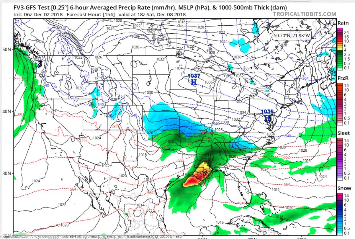
(I hope the picture is allowed).. My Apologies if it isn't.. Looks like Everyone starts out with Flakes.. though the next panel shows change-over to Mix/Rain.. Hopefully, More knowledgeable Mets can answer this.. How is this possible; the "Low" "BullDogs" (for the lack of a better term), into these pair of Strong highs? Shouldn't the Low track further South off the Coast? As Neither High budges AT ALL in the further panels.. .. 1037 & 1036 highs? This is What is referred to as a "Banana High"? I heard the term mention before, just trying to learn something here..
-
Observation, just came off the Beach, (Carolina Beach),, High tide @ 11:45 pm,, Strong steady ESE~SE Winds STEADY @ 20mph.. Beach is already beginning to experience some , (Higher than Normal High tide, pushed by Winds) overwash
-
yes, but you mean Carolina Beach..
-
I just that "alert" too on My phone.. (I'm in Wilmington)
-
Not really more like a "steady-State" IMOP.. Will be Fed from South to North By 86F Warm Gulf Stream Water(s) WHILE it sliding south-South West, In effect being "spoon fed", with Steady fresh Fuel... Say combined southward/SW motion and the 8-10 MPH Hot gulf stream waters, comin Northward.. Well Not much "upwelling" What-so-ever..
-
Yes I said this Late Last Week All Wrapped in a nice Box with a red Bow... The Box's name & contents were SHTF… I'm still bullish on a Wilmington/Cape Fear Landfall as I was last week... Though I wasn't expecting Flo to Stall and SET on top of Us though.. I wanted too "Share the Love" with Our inland Folks.. I had a few friends Leave Wilm today for Down south below Dirty Myrtle &Savannah GA , & Atlanta,Ga , I can only Imagine their Dismay to "bug out" only to be "followed", (if that comes to pass).. With that said... DT has some great commentary..
-
Ander420, Is in fact Quite Right If you seriously think about this. In todays Political Climate... With ALL the Major media News organization(s) HYPING up this Storm, OMG End of the World is coming… After being called out & caught-up in many________, ending up with Egg in their faces for the Past Two years... Time after time.. Screaming, now, LISTEN to US! We are "thinking for you, AND then Tell you WHAT to think & Do" (It's for the Children you know).. Gosh dern right the General Public at Large Will in fact Ignore ANY future Warnings.. Until it's to late... Look at Memes All over the net concerning, & making fun of Jim Cantore, when He shows up before & during a Major Weather event.. Then there WILL be the reasoning that yes, in fact, MSN & Media are "earning" the Moniker of Fake News.. With that said... Floyd dumped 19.50 +/- inches of Rain here in Wilm.. Ya'll remember what happened then.. I cannot Fathom 25~45 inches of rain with all the Development in the past 3~5 years in SENC.. Destruction would be on the Biblical Type scale.. Floyd AND Fran, times TWO...
-
Please FedEx Lumber to ME ASAP...
-
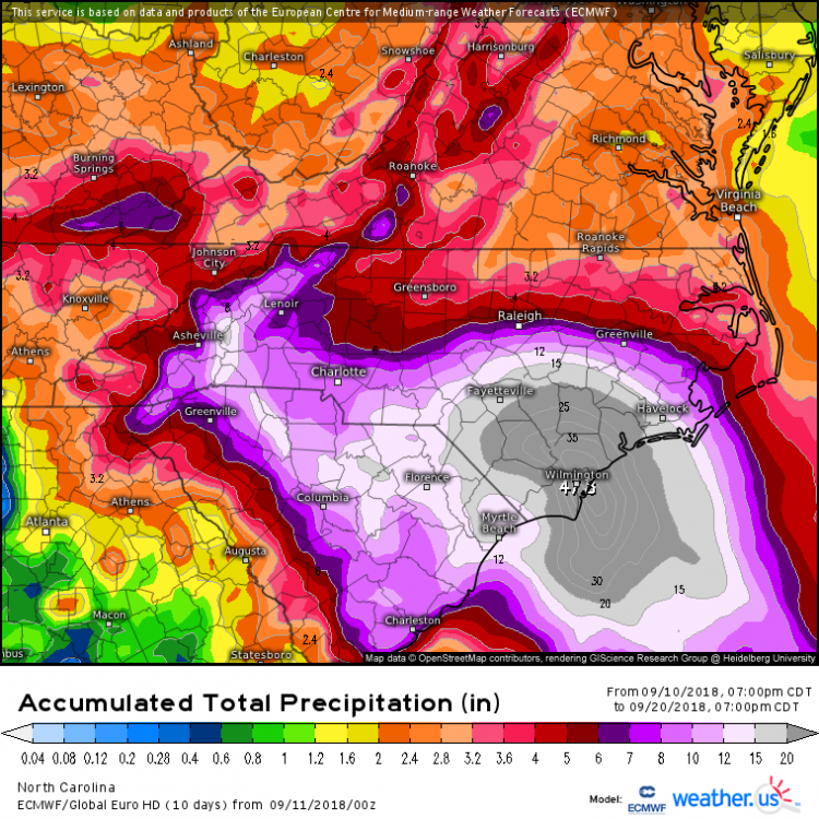
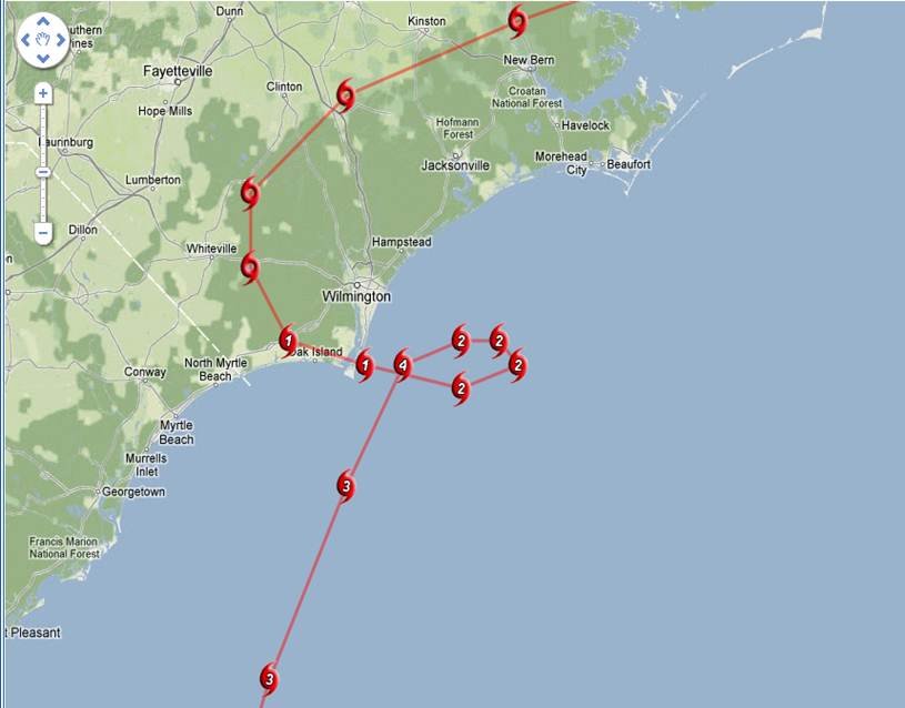
I know theres not a lot of "comparison" but...
-
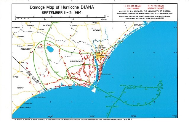
next..
-
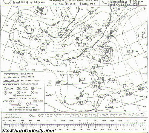
best I could finding" Diana" 1984
-
@DownEastnc you shooting doves yet? , get me a few crows while you're at it.. I think we'll all needa few
-
I said,, Cape fear Lock Since last week,, If not,, please bring My crow, I've got Wells BBQ
-
Never mind that 100 miles spread of cane force winds, It's going to be UGLY for ALL of us!
-
how can I say.. Ohh oo. Caving to the earlier Euro Tracks? break out the beer? Fire up the grille? Break out the CROW?
-
best I could find ATM.. https://journals.ametsoc.org/doi/10.1175/1520-0493(2001)129<1859%3ANSOTGO>2.0.CO%3B2 Looking for the atmospheric maps I'm coming up empty ATM.. Edit too add ALOT of Folks have even forgetting this one..
-
Dianne , 1984, If I recall
-
@Downeastnc remember this?
-
With-in 24 hours, We'll know about, 24 hours into landfall I'll try to get 'safely" as close as I can, record video.. (with-in reason & police).. I don't have a Wind aeromonitor , or barometric pressure gauge.. but I'll try to get good obs.. Are there "apps" for a smart phone,, android?
-
Thank you Sir, hope too post Obs & video..
-
Great too see some Long time posters show up..