

SENC
-
Posts
910 -
Joined
-
Last visited
Content Type
Profiles
Blogs
Forums
American Weather
Media Demo
Store
Gallery
Everything posted by SENC
-
best I could find ATM.. https://journals.ametsoc.org/doi/10.1175/1520-0493(2001)129<1859%3ANSOTGO>2.0.CO%3B2 Looking for the atmospheric maps I'm coming up empty ATM.. Edit too add ALOT of Folks have even forgetting this one..
-
Dianne , 1984, If I recall
-
@Downeastnc remember this?
-
With-in 24 hours, We'll know about, 24 hours into landfall I'll try to get 'safely" as close as I can, record video.. (with-in reason & police).. I don't have a Wind aeromonitor , or barometric pressure gauge.. but I'll try to get good obs.. Are there "apps" for a smart phone,, android?
-
Thank you Sir, hope too post Obs & video..
-
Great too see some Long time posters show up..
-
WOW that was wrong & you know it..
-
With the crazy QPF forecasted upstate.. Maybe I'm overthinking this... Though If I recall... Hugo & Floyd had "Officials" per se kinda worried about "Dam Failures, (Especially on South Carolina side of the NC/SC line).. Yes I'm including the Raleigh Triangle in My thoughts.. There are some pretty Large Lakes & Reservoirs up there, (Earthen Dams capped with Concrete).. With the CRAZY amount(s) of QPF forecasted, What is the consensus here of A VERY REAL possibility of one or more Large Dam Failures happening up there? Like Jordan Lake, Lake Wylee et al? I imagine lotsa "friends" downstream would be curious.. I mean those "amounts" are just Biblical… !!!
-
My call,, give Me crow with Well's BBQ Sauce.. Fran+Hugo+Floyd in a nice neat bow..
-
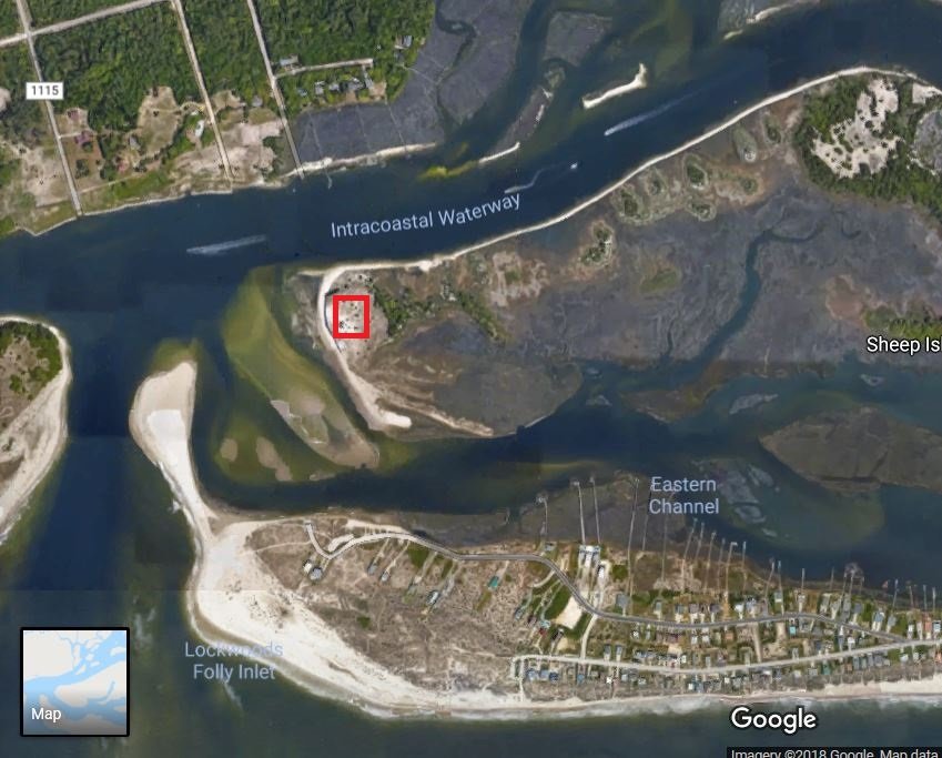
Sorry google is messing with Me,, this is the Spot, in red.. during Fran..
-
I recorded during Fran , on Sheep Island at 130 +/- before We had to "hunker down", and our instrument "crapped out" Cords.. You are forgetting Bald Head Island, Southport,, State Ports, and of course, Frying Pan Tower.. take those readings into consideration before posting, A lot more Station(s) are Accurately reporting recently.. With "Weather Stations"..
-
I resided on the beach @ landfall, took a trip to "sheep Island" during landfall, this one scares me..
-
Folks, & @downeastnc, honestly I've been through ALOT of canes.. This one Scares the be-Jesus outta me.. If it comes to a ILM (or close ) landfall..
-
OT, local report.. Chit Show has begun here in Wilm.. Botted Water GONE reports of gas Stations already running out.. I "managed" to get Gas, (about 40 hours "run-time") 20 gallons just as the station ran out.. Station "jacked" the price almost 25 cents while I was there "in-line".. I spent close to 80.00 in gas for My generator.. Then theres this report from the Carolina Beach Boat Ramp.. Meanwhile I'm watching a "parade" of boats leaving ILM.. """"Ok locals, I am hoping that most of us have common sense on here. My husband and I were taking our boat out of the water today, due to the impending storm, and I watch people arguing and fist-fighting at the boat ramp. Parking lot full of boaters, boaters 10 deep waiting in line to either put in or take out and tempers were high and fuming. A new boater backed down and then proceeded to wait on the boat to arrive. The new boater initiated the argument that continued for 30 good mins with several boaters. He was expecting everyone to move so his boat could come in. In the meantime, I counted 6 other boats docked and waiting for trailers to arrive so they could depart. Then my husband had pulled up and was about to back in when someone cut him off and zipped in. His boat was still coming in. I swear I just shook my head and said dear lord please get us out of the boat ramp safely without dying, because I know the storm you are sending will wash these fools away. Lesson, be kind and courteous and help out your fellow boater. Sheesh. CB police or whom ever the Public boat dock officials are need to monitor it over the next few days. People are nuts.""
-
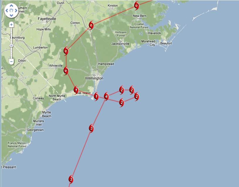
So who wants too chase? Brunswick/New hanover landfalls..
-
Then you don't remember the "Super storm of "93"? OMG that wasn't even a cane,, 80's F to snow with-in 10 miles! THAT was a Storm My friend!
-
I was wondering when someone would bring that up,, honestly..
-
Don't wait until the last minute.. Gas cans will be gone" AND" no gas to be had.. do it NOW..
-
I and DownEast,, Digress.. I'm sure He agree's I hope pulled he button on that genset. I started mine.. got gas cans at the ready ..
-
I'll try too answer this.. I purchased, a B & S "storm responder" from Sears.. 5K~6K watts.. Runs 11 hours on 5 gallons of gas.. (depending on the Load Cycle).. It is enough, I "TESTED" Loading on my home.. I was enough to power My computer/freezer/fridge/TV/ AND My AC/Heat pump.. (Barely all @ once).. I also had a Generac 6000 that could do same amount of "load" , but less hours run time.. Hooking one up... YOU CAN USE THE 120/240 "LINE OUTLET" TO Reverse plug per'se, into your DRYER outlet... making it a "inlet" into your home powering it. DOING SO MAKE SURE YOU TRIP YOUR MAIN BREAKER TO THE GRID!!!!!!! aS "YOUR POWER" will go to the nearest transformer turning your measly power into 7K +/- volts possibly causing death too line workers thinking those power lines were not "energized"... My house is "wired" for a Gen-set already.. All I have to do is trip My breaker & I'm set.. Generator runs in the detached garage.. Of course FOLLOW SAFTEY GUIDELINES, in other words Carbon monoxide poisoning.. Smaller portable generators (1000K ~ 3000K watts) are enough to power your fridge/freezer and maybe light & TV/Radio.. Though the extension cord outlets, (don't forget to buy those, AND long enough to have the generator OUTSIDE.. ) Edit too add, (about the transfer Switch on breaker panel),, I just cut the Main breaker.. I carry about 20 gallons of fuel, because I'm right on the main grid.. Generators are great to have in winter, In case of Ice Storms also.. Be sure (If you buy one) buy your gas cans NOW, you'll have mucho trouble finding some.. Plus I got a Boat tank that hold 30 gallons if I've got to use that too..
-
Cape Fear Lock
-
Well this is Interesting... Moreover, Arctic mid-summer temperatures, north of 80°N latitude, have dipped to near freezing over the past days. This is likely in large part linked to the cold North Atlantic sea surface temperatures we’ve been witnessing. All this suggests ocean cycles, and not CO2, are the real Arctic drivers. Snow and ice climbing past decade The cold polar temperatures are naturally having an impact on Arctic snow and ice. Japanese blogger Kirye tweeted here that Arctic sea ice volume is currently at the 4th highest level since 2003, thus defying the dire alarmist predictions of Arctic sea ice disappearing by now. ------------------------- 40-year veteran meteorologist Joe Bastardi at WeatherBell’s Saturday Summary shows how the Earth’s surface has cooled dramatically over the past three years and that Arctic sea ice is piling up. http://notrickszone.com/2018/07/15/global-sea-sea-surface-temperatures-have-seen-pretty-dramatic-turnaround-says-40-year-meteorologist/
-
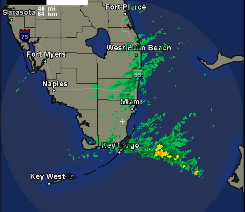
Like this? Convective T-Storms firing..
-
Har! Har! Har!!!!! OMG YOU are so friggin right!!!!!!! Congrats to those that got a "dusting of snow" especially,,, to those that got good amounts.. For all the others.. We down this way don't get hyped up at ALL.. As We hardly NEVER get snow, or Ice even. Our snow(s) always come as a pleasant surprise.. One GOOD thing is coming out of this, calling it Our silver lining.. At LEAST these Temps will kill the dern Skeeters off, here in the Low country until Spring.

