Blue Ridge
-
Posts
1,533 -
Joined
-
Last visited
Content Type
Profiles
Blogs
Forums
American Weather
Media Demo
Store
Gallery
Everything posted by Blue Ridge
-

Winter 'Tis the Season Banter Thread 2018-2019
Blue Ridge replied to Carvers Gap's topic in Tennessee Valley
define "real weather"... -
Winter 'Tis the Season Banter Thread 2018-2019
Blue Ridge replied to Carvers Gap's topic in Tennessee Valley
RE: Grant Williams, many mock drafts, which fall somewhere between crabgrass and 384 hr GFS on the usefulness scale, project him going in the low-20s and Schofield in the upper-20s. I could see a team like Portland, who seems to be perpetually short on depth at wing, using a pick on him. His jumper isn't bad; he has good form. He's 36% from three (9/25), which seems to be a result of utilization more than lack of ability. His body and game reminds me somewhat of Draymond Green at Michigan State. Compare Dray's senior season to Grant's current season; the numbers are eerily similar. (Data from Sports Reference CBB)
-
January 23-27th 2019 Short Term Winter Threats.
Blue Ridge replied to John1122's topic in Tennessee Valley
Based on the streamers showing up on KMRX, that's likely the case.
-
Rain/snow mix in town right now as the back edge approaches. ...annnnd it's gone.
- 355 replies
-
- 1
-

-
- observations
- measurements
- (and 15 more)
-
Bad day to forget my Kestrel handheld. Something evil just unloaded overhead. Roof shaking wind gusts. Easily 45+ MPH at low elevation.
-
January 2019 Medium/Long Range Pattern Discussion
Blue Ridge replied to John1122's topic in Tennessee Valley
Just for kicks and giggles... Average low in Fort Dodge, IA (approx. dead center of the -48 anomaly area on the Euro) is 8.2. -61 departure equates to -52.8. -
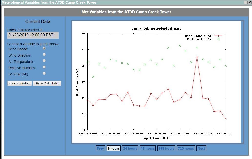
Peak gust appears to be around 37 m/s, with peak sustained wind of roughly 33 m/s. That's approx. 74 mph. Wind is whipping in Greeneville proper as well.

- 355 replies
-
- 2
-
-
- observations
- measurements
- (and 15 more)
-
The link to Camp Creek Tower observations, for those who would like to follow along: https://oculus.atdd.noaa.gov/campcreek/
-
Winter 'Tis the Season Banter Thread 2018-2019
Blue Ridge replied to Carvers Gap's topic in Tennessee Valley
Boston has dipped to #9, but LA is #2. Compare that to KC (#32) and New Orleans (#50). While we are on the subject: Knoxville is now #60, while the Tri-Cities have dipped to #102. Nashville is #27; Memphis #51; Chatt #83; Jackson #177. Back to football: the no-call DPI was atrocious, as was the roughing penalty on KC. I had no skin in the AFCCG, but was really pulling for the Saints. Count me out on Super Bowl viewing. -
January 2019 Medium/Long Range Pattern Discussion
Blue Ridge replied to John1122's topic in Tennessee Valley
Yes, I'll take one 1/27/98 redux, please. -
50+ DBZ over Bulls Gap right now. The back edge looks wild. Agreed. A slushy 1/2" has accumulated here.
- 355 replies
-
- 3
-
-
- observations
- measurements
- (and 15 more)
-
Good moderate burst of snow at the office currently. Huge flakes.
- 355 replies
-
- 1
-
-
- observations
- measurements
- (and 15 more)
-
January 2019 Medium/Long Range Pattern Discussion
Blue Ridge replied to John1122's topic in Tennessee Valley
I lived in Erwin at the time. Though I was young, I remember the storm vividly. My dad is 6'3" and snow depth topped his knees. I recall him measuring "over two feet" with a yardstick in the aftermath; IIRC, this was several hours after snow had ended. Bear in mind, my parents' home is at ~2000' but in a favored area just west of Unaka Mtn. That location is often the beneficiary of the "squeezing" that occurs during events with a proper trajectory. NW flow events were always fun as a kid. Some in Limestone Cove and Flag Pond (~3500'+) claim to this day they saw four feet from this storm. Just conjecture on my part, but they likely aren't exaggerating much, if any. -
A new record of 75 has been set at TRI as of 1425. TYS has thus far topped out at 73. Gusting to 38 MPH as of 1535.
- 355 replies
-
- 3
-

-
-
- observations
- measurements
- (and 15 more)
-
It's 15-20 minutes from my front door. We'll set up an AmWx TN Valley meet-up!
- 355 replies
-
- 1
-
-
- observations
- measurements
- (and 15 more)
-
Suddenly got dark outside. Impressive anvils for December. Looks like spring with clear blue skies east, dark gray west. No thunder audible or lightning visible, but I have a feeling we’ll be putting the “thunder in winter” anecdote to the test again...

- 355 replies
-
- 4
-
-
- observations
- measurements
- (and 15 more)
-
Incredible. Looks like KTRI bottomed out at 14°, while Abingdon dipped to 9°. Meanwhile, a PWS in Bristol, VA, recorded a low of 4.3°, while a PWS in Meadowview, VA recorded a low of 2.6°. Obvious cautions about relying on PWS data apply.
- 355 replies
-
- 2
-
-
- observations
- measurements
- (and 15 more)
-
Yes, not even my car under our carport was spared. Fortunately, that’s the only issue I encountered on my commute. (My office complex’s parking lot is a different story.)
-
Incredibly thick fog has developed within the last hour. Temp is hovering around freezing. This may spell trouble in the morning.
- 355 replies
-
- 2
-
-
- observations
- measurements
- (and 15 more)
-
Winter 'Tis the Season Banter Thread 2018-2019
Blue Ridge replied to Carvers Gap's topic in Tennessee Valley
@nrgjeff KU or Michigan should be #1, but my money is on Duke retaking the top spot. No questioning that the Dukie bias is real this year... -
My wife said the exact same thing, lol. I measured 2.5" of new snow here, and it's still coming down. Just enough to excuse working from home today!
-
Winter 'Tis the Season Banter Thread 2018-2019
Blue Ridge replied to Carvers Gap's topic in Tennessee Valley
Blunder and John, I share your disappointment in lack of snow. Purely from a scientific standpoint, this storm was fascinating, and I believe there are valuable lessons to be learned. From an amateur/hobbyist viewpoint, such lessons are invaluable in analyzing model output and filtering through the noise. In particular, the hi-res models scored a coup with the enhancement shown in Sullivan and Hawkins Counties and the shadow shown in southern Washington, Greene, and Carter counties. Our microclimates are simultaneously infuriating and enthralling. -
Winter 'Tis the Season Banter Thread 2018-2019
Blue Ridge replied to Carvers Gap's topic in Tennessee Valley
After watching UK’s loss to Seton Hall, I believe Auburn and UT to be the class of the SEC in 18/19. Point Guard U looked completely lost at the position yesterday. Of course, Florida will be tough as always, and Clanga will make some noise in conference play. Look out for LSU or Arkansas as a possible sleeper. -
Do we have anyone here from Mt Carmel? At 1145, MRX relayed a report from 1 WNW Mt Carmel of 11”. If this has ground truth, that same spot would be well over a foot by now.
-
Seeing photos from the northern part of the county and it’s a different world than here. Also seeing that there are several accidents along 81. I forget which model/run it was, but I made a comment about it wanting to wipe the 81 corridor off the map. As it turns out, that was somewhat accurate...lol.