

Blue Ridge
-
Posts
1,598 -
Joined
-
Last visited
Content Type
Profiles
Blogs
Forums
American Weather
Media Demo
Store
Gallery
Everything posted by Blue Ridge
-

Christmas Eve/Christmas 2020 Arctic Express Snow Obs.
Blue Ridge replied to John1122's topic in Tennessee Valley
Closing in on 5” here. Lighter band now, but much smaller flakes. . -
Christmas Eve/Christmas 2020 Arctic Express Snow Obs.
Blue Ridge replied to John1122's topic in Tennessee Valley
Classic MRX now-casting woes. . -
Christmas Eve/Christmas 2020 Arctic Express Snow Obs.
Blue Ridge replied to John1122's topic in Tennessee Valley
Just switched to nickel-size flakes. Timed out almost perfectly with CC transition line on radar. -
Dandridge Dollop 12/24/20 Storm Thread (Winter Wonderland)
Blue Ridge replied to AMZ8990's topic in Tennessee Valley
Chasing down the 45+ DBZ returns overhead. Unreal.- 847 replies
-
- 1
-

-
- cold temperatures
- snow
- (and 8 more)
-
Christmas Eve/Christmas 2020 Arctic Express Snow Obs.
Blue Ridge replied to John1122's topic in Tennessee Valley
Arctic front has arrived. Worst wind of the whole event just mixed down. I just watched a rocking chair take a ride across my patio. Edit: check out the waves visible in the velocity product! -
Christmas Eve/Christmas 2020 Arctic Express Snow Obs.
Blue Ridge replied to John1122's topic in Tennessee Valley
Damn near SSE at it’s current trajectory. -
Christmas Eve/Christmas 2020 Arctic Express Snow Obs.
Blue Ridge replied to John1122's topic in Tennessee Valley
Watching this cold advance in real-time through the Plateau will be interesting.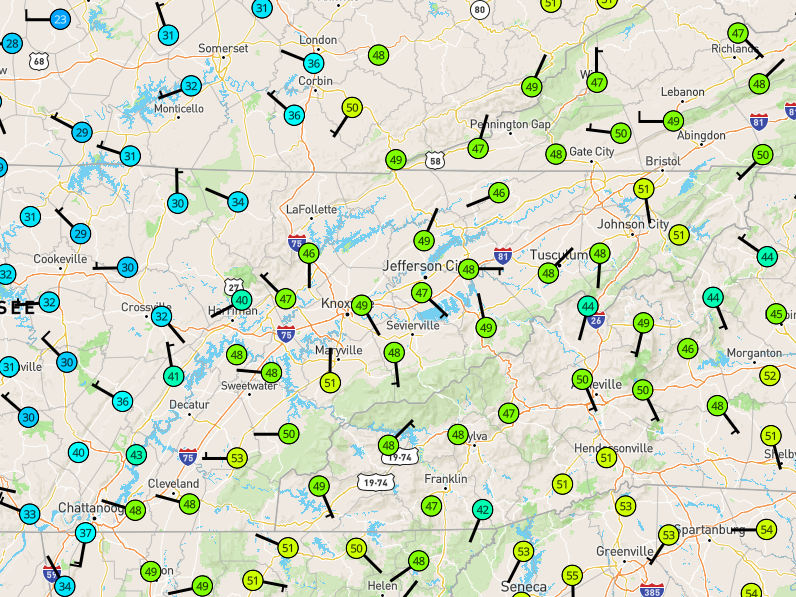
-
Dandridge Dollop 12/24/20 Storm Thread (Winter Wonderland)
Blue Ridge replied to AMZ8990's topic in Tennessee Valley
A note for all trying to predict MRX’s next move: The overnight AFD and update package usually hits around 0300. As with the afternoon suite, this is sometimes delayed during active weather. Highly unlikely we see any alteration to the warning/advisory package until then. -
Dandridge Dollop 12/24/20 Storm Thread (Winter Wonderland)
Blue Ridge replied to AMZ8990's topic in Tennessee Valley
From https://www.weather.gov/mrx/watchwarnadv: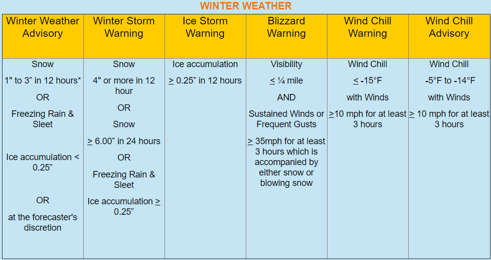
- 847 replies
-
- 3
-
-

-
- cold temperatures
- snow
- (and 8 more)
-
Dandridge Dollop 12/24/20 Storm Thread (Winter Wonderland)
Blue Ridge replied to AMZ8990's topic in Tennessee Valley
Santa came early... Edit to add: Map hasn't yet updated. Looks like they upgraded watch to warning and SPS to WWA except the furthest SW counties (incl. Hamilton). Edit 2: To recap: WSW for 2-4", locally higher depending on elevation; WWA for 1-3"; SPS remains for minimal accumulations and hazardous travel. Edit 3: Map just updated.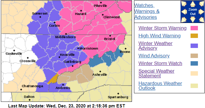
- 847 replies
-
- 5
-
-
- cold temperatures
- snow
- (and 8 more)
-
Dandridge Dollop 12/24/20 Storm Thread (Winter Wonderland)
Blue Ridge replied to AMZ8990's topic in Tennessee Valley
Adding to this for those unfamiliar or new: MRX generally issues its afternoon AFD, advisory/warning products, and forecast updates around 3:00 pm. For storms such as this, they do have a tendency to push a bit (I've seen as late as 4:00 pm).- 847 replies
-
- 2
-
-
- cold temperatures
- snow
- (and 8 more)
-
Dandridge Dollop 12/24/20 Storm Thread (Winter Wonderland)
Blue Ridge replied to AMZ8990's topic in Tennessee Valley
Also worth noting that GSP issued a Winter Storm Watch (2-5", wind gusts to 40 MPH) for Avery, Madison, Mitchell, and Yancey, NC. -
Dandridge Dollop 12/24/20 Storm Thread (Winter Wonderland)
Blue Ridge replied to AMZ8990's topic in Tennessee Valley
Charleston, WV (RLX)- 847 replies
-
- 1
-
-
- cold temperatures
- snow
- (and 8 more)
-
Dandridge Dollop 12/24/20 Storm Thread (Winter Wonderland)
Blue Ridge replied to AMZ8990's topic in Tennessee Valley
Still too early for WWAs. Even if they decide on warning-criteria for the mtns, a watch isn't likely until the overnight/AM at best. We won't see WWA or WSW products until tomorrow PM at best, and possibly not until the mid-evening update or overnight/AM.- 847 replies
-
- 1
-
-
- cold temperatures
- snow
- (and 8 more)
-
Dandridge Dollop 12/24/20 Storm Thread (Winter Wonderland)
Blue Ridge replied to AMZ8990's topic in Tennessee Valley
If you're taking requests from the peanut gallery... Dandridge Dollop or Dandridge Destroyer both have a nice ring.- 847 replies
-
- 3
-
-
- cold temperatures
- snow
- (and 8 more)
-
Dandridge Dollop 12/24/20 Storm Thread (Winter Wonderland)
Blue Ridge replied to AMZ8990's topic in Tennessee Valley
The 75 corridor, especially north, has been pretty consistently in the game with each model run. If a stronger, more amplified solution like the NAM presents comes to fruition, you're in a very good spot. Edit to add: I'll echo the caveat @Carvers Gap mentioned - microclimate oddities do apply...- 847 replies
-
- 2
-
-
- cold temperatures
- snow
- (and 8 more)
-
Dandridge Dollop 12/24/20 Storm Thread (Winter Wonderland)
Blue Ridge replied to AMZ8990's topic in Tennessee Valley
Not to mention, the heat island seems to follow the river through the valley a ways. You double dip on unfortunate circumstances. Yet, seems like we have a few storms a decade in which SWVA and Sullivan are crushed while anything south of the Sullco/Washco border are blanked.- 847 replies
-
- 5
-
-
- cold temperatures
- snow
- (and 8 more)
-
Dandridge Dollop 12/24/20 Storm Thread (Winter Wonderland)
Blue Ridge replied to AMZ8990's topic in Tennessee Valley
Hi, @bluegrassweather71! Welcome. @Carvers Gap hit the nail on the head. MRX are the kings/queens of hedging, but this is a situation in which it is certainly warranted. Given the high uncertainty, conservatism is warranted.- 847 replies
-
- 3
-
-
- cold temperatures
- snow
- (and 8 more)
-
Oak Moon Upslope/ Upper Low Storm Obs
Blue Ridge replied to Holston_River_Rambler's topic in Tennessee Valley
Nice little shower rotating through right now. Might be enough moisture out there to make sunset interesting tonight.- 300 replies
-
- 1
-
-
- upslope snow
- upper level disturbance
- (and 3 more)
-
Oak Moon Upslope/ Upper Low Storm Obs
Blue Ridge replied to Holston_River_Rambler's topic in Tennessee Valley
The best moisture and lift remained concentrated south and west of roughly this line: I’ve seen a few reports from Greene Co. and Washington Co. of 3” or better. Family in lower Unicoi Co. have damn near 4”. Meanwhile, Kingsport and Gray are lucky to have an inch, while friends in NW JC are reporting 1.5”. As odd as it looked, I believe MRX was right to exclude Johnson County from the WSW area.- 300 replies
-
- 3
-
-
- upslope snow
- upper level disturbance
- (and 3 more)
-
Oak Moon Upslope/ Upper Low Storm Obs
Blue Ridge replied to Holston_River_Rambler's topic in Tennessee Valley
6” on Roan Mtn [edit: specifies 3700’ - that’s not quite at the summit]- 300 replies
-
- 3
-
-
- upslope snow
- upper level disturbance
- (and 3 more)
-
Oak Moon Upslope/ Upper Low Storm Obs
Blue Ridge replied to Holston_River_Rambler's topic in Tennessee Valley
Interesting pulse rotating through right now...- 300 replies
-
- 2
-
-
- upslope snow
- upper level disturbance
- (and 3 more)
-
Oak Moon Upslope/ Upper Low Storm Obs
Blue Ridge replied to Holston_River_Rambler's topic in Tennessee Valley
A solid 2” event IMBY. Main roads are well treated, but side roads are fairly slick. Woke up at 0400 and it was absolutely ripping. Should have gotten outside for a measurement while it was fresh; judging solely on appearance, I’m guessing a bit was lost. Like Holston mentioned above, the grass has that splotchy look already.- 300 replies
-
- 1
-
-
- upslope snow
- upper level disturbance
- (and 3 more)
-
Oak Moon Upslope/ Upper Low Storm Obs
Blue Ridge replied to Holston_River_Rambler's topic in Tennessee Valley
From the 9:00 PM AFD update: Further east in the Valley, the system looks to have slightlyover-performed as a few locations have reported 1.0-1.5 inches. You don’t say.- 300 replies
-
- 4
-

-
-
- upslope snow
- upper level disturbance
- (and 3 more)
-
Oak Moon Upslope/ Upper Low Storm Obs
Blue Ridge replied to Holston_River_Rambler's topic in Tennessee Valley
Ripping for the last hour. Went from nada to half an inch.- 300 replies
-
- 3
-
-
- upslope snow
- upper level disturbance
- (and 3 more)