

Blue Ridge
-
Posts
1,598 -
Joined
-
Last visited
Content Type
Profiles
Blogs
Forums
American Weather
Media Demo
Store
Gallery
Everything posted by Blue Ridge
-

TN valley heavy rain/flooding week of whenever
Blue Ridge replied to janetjanet998's topic in Tennessee Valley
Easy, dude. @janetjanet998 has been instrumental in flood coverage since this risk first presented itself. Also, we don't "stick to areas" here. The warning you referred to is an areal flood warning. Not the same as a Flash Flood Warning, and certainly not given the same priority. FFWs trigger EAS. -
TN valley heavy rain/flooding week of whenever
Blue Ridge replied to janetjanet998's topic in Tennessee Valley
Two notes, FWIW. 1) There appears to be westerly forcing pushing some of the training cells in middle TN more eastward. This is visible on KHTX. Watch the push around the 50nmi band. Pure conjecture without the aid of a sounding: flow aloft may be more from the west than south, pushing the higher-topped convection east while flow in the lower levels pushes more north. Just a thought. https://weather.cod.edu/satrad/nexrad/index.php?type=HTX-N0Q-0-6 2) Not sure I see much opportunity for clearing across the moderate risk area. That said, that's some nice convection moving into the Arklatex... https://weather.cod.edu/satrad/exper/?parms=regional-southeast-truecolor-24-1-100-1&checked=map&colorbar=undefined -
TN valley heavy rain/flooding week of whenever
Blue Ridge replied to janetjanet998's topic in Tennessee Valley
Can't say I've seen an area go from no FFW to a PDS Flash Flood Emergency in one fell swoop. -
TN valley heavy rain/flooding week of whenever
Blue Ridge replied to janetjanet998's topic in Tennessee Valley
...FLASH FLOOD EMERGENCY FOR KNOXVILLE TENNESSEE AND GREATER KNOX COUNTY... The National Weather Service in Morristown has issued a * Flash Flood Warning for... Knox County in east Tennessee... * Until 130 PM EST. * At 1036 AM EST, emergency management reported heavy rain across the warned area. Up to 3 inches of rain have already fallen over the last 3 to 4 hours with an additional 1 to 2 inches possible over the next 2 hours. Flash flooding is already occurring. This is a FLASH FLOOD EMERGENCY for Knoxville. This is a PARTICULARLY DANGEROUS SITUATION. SEEK HIGHER GROUND NOW! -
TN valley heavy rain/flooding week of whenever
Blue Ridge replied to janetjanet998's topic in Tennessee Valley
After missing out on all but drizzle yesterday, I woke up to 1.63" and a rushing stream in my front yard. I don't so much as have a ditch line. -
TN valley heavy rain/flooding week of whenever
Blue Ridge replied to janetjanet998's topic in Tennessee Valley
PRELIMINARY LOCAL STORM REPORT...SUMMARY NATIONAL WEATHER SERVICE MORRISTOWN TN 346 PM EST WED FEB 20 2019 ..TIME... ...EVENT... ...CITY LOCATION... ...LAT.LON... ..DATE... ....MAG.... ..COUNTY LOCATION..ST.. ...SOURCE.... ..REMARKS.. 0700 AM NON-TSTM WND GST COVE MOUNTAIN 35.71N 83.59W 02/20/2019 M87 MPH SEVIER TN MESONET 0630 AM NON-TSTM WND GST CAMP CREEK 36.09N 82.77W 02/20/2019 M81 MPH GREENE TN MESONET CORRECTS PREVIOUS NON-TSTM WND GST REPORT FROM CAMP CREEK. MEASURED GUST AT THE NOAA/ATDD TOWER. EARLIER REPORTED GUST WAS ERRONEOUS. AFTER QUALITY CONTROL OF THE RAW DATA 81 MPH WAS CONFIRMED TO BE THE CORRECT WIND SPEED. 0659 AM NON-TSTM WND GST 4 SE CEDAR CREEK 35.98N 82.84W 02/20/2019 M51 MPH GREENE TN MESONET MESONET STATION PGVT1, NOLICHUCKY (4 SE CEDAR CREEK). 0327 AM NON-TSTM WND GST 1 SE SIGNAL MOUNTAIN 35.12N 85.33W 02/20/2019 M49 MPH HAMILTON TN MESONET MESONET STATION C9567, SIGNAL MOUNTAIN. 1000 AM NON-TSTM WND GST 4 WSW ROAN MOUNTAIN 36.17N 82.15W 02/20/2019 M47 MPH CARTER TN MESONET MESONET STATION D5724, 4 WSW ROAN MOUNTAIN. 0106 AM NON-TSTM WND GST 5 SE POWELLS CROSSROADS 35.13N 85.43W 02/20/2019 M43 MPH MARION TN MESONET MESONET STATION PCFT1, PRENTICE COOPER SF. 0905 AM NON-TSTM WND GST 1 WNW UNICOI 36.20N 82.37W 02/20/2019 M43 MPH UNICOI TN MESONET MESONET STATION UNIT1, WATAUGA (1 WNW UNICOI). -
TN valley heavy rain/flooding week of whenever
Blue Ridge replied to janetjanet998's topic in Tennessee Valley
Just hit ~110 again. I believe it may be legit. If so, that's incredible. -
TN valley heavy rain/flooding week of whenever
Blue Ridge replied to janetjanet998's topic in Tennessee Valley
For those playing along at home, 1 m/s = 2.237 mph. Alternatively, use this handy calculator. Ignoring the high outliers, it looks like Camp Creek is consistently flirting with 40 m/s - nearly 90 mph. (FYI - if that 54 m/s observation is verified, that's ~121 mph.) @Math/Met Thoughts?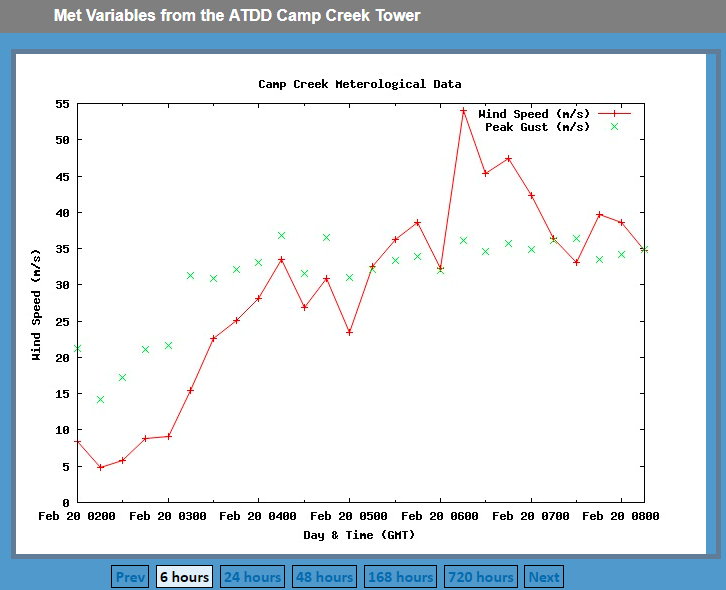
-
TN valley heavy rain/flooding week of whenever
Blue Ridge replied to janetjanet998's topic in Tennessee Valley
The latest from MRX: -
...A TORNADO WARNING REMAINS IN EFFECT UNTIL 830 PM CST FOR SOUTHWESTERN DAVIDSON...NORTHWESTERN WILLIAMSON AND SOUTH CENTRAL CHEATHAM COUNTIES... At 812 PM CST, a severe thunderstorm capable of producing a tornado was located over Pegram, or 14 miles south of Ashland City, moving east at 40 mph. HAZARD...Tornado. SOURCE...Radar indicated rotation. IMPACT...Flying debris will be dangerous to those caught without shelter. Mobile homes will be damaged or destroyed. Damage to roofs, windows, and vehicles will occur. Tree damage is likely. This tornadic thunderstorm will remain over mainly rural areas of southwestern Davidson, northwestern Williamson and south central Cheatham Counties. This includes Interstate 40 between mile markers 182 and 197.
-
The GFS has continually flirted with severe since Jax mentioned it above - less so than the 12z Euro, mercy. Fitting, as we are almost to the 11 year anniversary of the Super Tuesday outbreak.
-
Looks like the GFS has backed off a bit for now. Way too early to tell obviously. <banter>I'm all too happy to throw in the towel on winter early if that would net an active spring, but I won't hold my breath.</banter>
-
It was felt in East Tennessee as well. It was enough to shake the walls much like a strong wind gust.
-
Devastating tornado strikes Joplin, Missouri
Blue Ridge replied to Hoosier's topic in Weather Forecasting and Discussion
I typically lurk the severe weather threads outside of the SE, but I wanted to pop by to say I'm glad JoMo is safe and well. Amazing stories are being told here. I'm certainly bookmarking this thread for future reference.

